
Feed aggregator
Chronic fatigue syndrome seems to have a very strong genetic element
ESA's XMM-Newton Examines Comet 3I/ATLAS Prior to Closest Earth Passage Friday
Everyone’s favorite interstellar comet posed for one more portrait recently. The European Space Agency’s XMM-Newton mission nabbed 3I/ATLAS on December 3rd from about 283 million kilometers distant. This comes as the comet is set to make its closest passage versus Earth this coming Friday, on December 19th.
New Landsat Science Team Announced
The U.S. Geological Survey, in cooperation with NASA, has named the new Landsat Science Team that will support the world’s longest-running Earth observation mission for a planned 2026-2030 term.
The team brings together experts from universities, private industry, and federal and international agencies to help the U.S. Geological Survey (USGS) and NASA ensure Landsat continues delivering trusted, publicly available data that supports disaster response, agricultural management, water resources, land stewardship, and national security.
The Landsat Science Team supports the USGS and NASA in maintaining scientific integrity, data quality, and mission continuity across the Landsat program. Their work informs mission planning and development and helps maximize the value of the Landsat archive through improved data products, expanded applications and strategic insight that helps the Landsat program continue to serve the public effectively.
The Landsat Science Team will provide collective analysis and advice on a range of priority issues as defined by the USGS and NASA. In addition, each team member will lead research on a variety of topical areas deemed to be of interest to the Landsat program.
Research areas include atmospheric correction and calibration methods to ensure consistent reflectance across the Landsat archive. Team members will also look at improving data processing pipelines and interoperability with international satellite systems to support integrated Earth observations. Several studies are focused on land-surface processes, including crop condition, evapotranspiration, soil and residue detection, and non-photosynthetic vegetation, which support agricultural monitoring and conservation.
Water cycle and aquatic focused research includes inland and coastal water-quality mapping, harmful algal bloom detection, and refined snow cover characterization. Additional studies address fire monitoring, volcanic activity, and geothermal systems. Other work is centered on developing tools that help translate Landsat data into actionable products for science, management, and policy.
Atmospheric Correction and Calibration
Pathfinding the steps to ensure global analysis ready consistent reflectance from the Landsat MSS to Landsat Next era
- Dr. David Roy (PI), Michigan State University
- Dr. Hankui K. Zhang, South Dakota State University
- Dr. Lin Yan, Michigan State University
Fully probabilistic atmospheric correction for Landsat
- Dr. Nimrod Carmon (PI), University of California, Los Angeles
- Dr. Gregory Okin, University of California, Los Angeles
Maintenance and Refinement of the Land Surface Reflectance Code (LaSRC) for Landsat and Sentinel 2
- Dr. Eric Vermote (PI), NASA Goddard Space Flight Center
Towards a harmonized atmospheric correction for EnMAP, CHIME, Landsat archive, and Landsat Next observables
- Dr. Raquel De Los Reyes (PI), The German Aerospace Center (DLR)
Interoperability and Data Processing
Synergistic data processing pipelines for Landsat and European satellite missions
- Dr. David Frantz (PI), Trier University
- Dr. Patrick Hostert, Humboldt University of Berlin
- Dr. Sebastian van der Linden, University of Greifswald
- Dr. Dirk Pflugmacher, Humboldt University of Berlin
- Dr. Cornelius Senf, Technical University of Munich
Stronger together – next generation interoperability for Landsat and Copernicus
- Dr. Peter Strobl (PI), European Commission
Maximizing the impact of interoperable Landsat Analysis-Ready Surface Reflectance for Operational Land, Water and Antarctic Monitoring
- Medhavy Thankappan (PI), Geoscience Australia
- Dr. Kimberlee Baldry, Geoscience Australia
- Dr. Courtney Bright, Commonwealth Scientific and Industrial Research Organisation (CSIRO)
Agriculture, Vegetation, and Land Surface Processes
Developing non-photosynthetic vegetation cover capabilities for Landsat Next
- Dr. Phillip Dennison (Co-PI), University of Utah
- Dr Michael Campbell (Co-PI), University of Utah
Improving and synergizing Landsat evapotranspiration and albedo using multi-satellite observations
- Dr. Yun Yang (PI), Cornell University
- Dr. Zhuosen Wang, University of Maryland
OpenET: Supporting US sustainable water management with Landsat
- Dr. Forrest Melton (PI), NASA Earth Science Division
From leaf to Landsat: A multi-scale approach to developing information for agricultural management from Landsat Next
- Dr. Kyle Kipper (PI), USDA Agriculture Research Service
- Dr. Martha Anderson, USDA Agriculture Research Service
Measuring Agricultural Conservation Land Cover with Next Generation Earth Observation: Detecting Green Vegetation, Crop Residue, and Soil in the Context of Surface Moisture Variability
- Dr. Dean Hively (PI), USGS Lower Mississippi Water Science Center
Tracking Crop Growth and Condition in Near Real-time Using Harmonized Landsat and Sentinel-2 Data
- Dr. Feng Gao (PI), USDA Agriculture Research Service
Water, Snow, and Aquatic Systems
Harmonizing inland and coastal water quality monitoring from the Landsat Program: Harmful algal blooms
- Dr. Ryan O’Shea (PI), Science Systems and Applications, Inc
Next generation snow cover mapping and establishment of a long-term ground validation site
- Dr. Edward Bair (PI), Leidos, Inc.
Fire and Disturbance
Advancing fire monitoring with Landsat Next and Canada’s WildFireSat
- Dr. Morgan Crowley (PI), Canadian Forest Service
Volcanoes and Geothermal Systems
Characterizing/monitoring active volcanoes and geothermal systems with Landsat
- Dr. Greg Vaughan (PI), USGS Astrogeology Science Center
Science Applications and User Engagement
From pixels to products to policy: Creating and sharing information to advance science and applications with Landsat
- Dr. Mike Wulder (PI), Canadian Forest Service
Winds, waves, and ice near a remote town on the Chukchi Peninsula have sculpted a…
Article
16 hours ago
4 min read Maintaining the Gold Standard: The Future of Landsat Calibration and Validation
The NASA CalVal team spent 2025 improving their calibration techniques, strengthening collaboration, and sharing their…
Article
1 day ago
3 min read What’s Next for HLS
In 2025, the Harmonized Landsat and Sentinel-2 (HLS) program established itself as a cornerstone for…
Article
1 day ago
NASA Langley Research Center: 2025 Year in Review
The future of flight, space exploration, and science starts at NASA’s Langley Research Center in Hampton, Virginia, where we have been advancing innovation for more than 100 years. Join us as we look back at NASA Langley’s achievements in 2025 that continued our storied legacy of pushing the boundaries of what is possible.
Langley Researchers Explore MARVL-ous Technology for Future Trips to Mars Modular Assembled Radiators for Nuclear Electric Propulsion Vehicles, or MARVL, aims to take a critical element of nuclear electric propulsion, its heat dissipation system, and divide it into smaller components that can be assembled robotically and autonomously in space. This is an artist’s rendering of what the fully assembled system might look like.NASA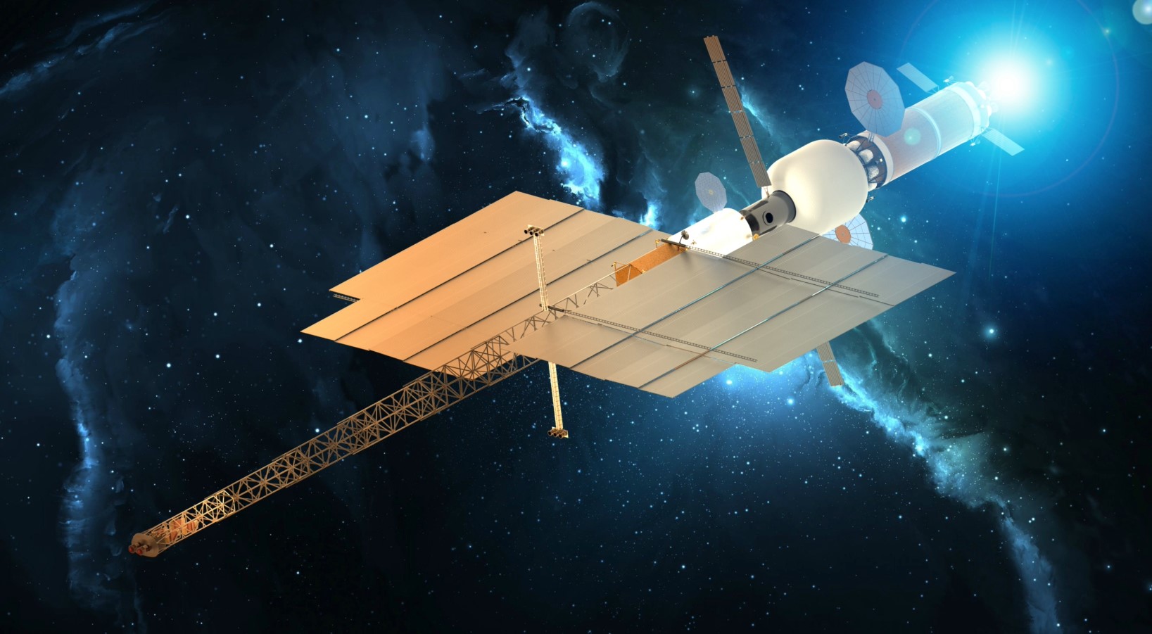
As NASA returns astronauts to the Moon through the agency’s Artemis campaign in advance of human exploration of Mars, researchers at Langley are exploring technology that could significantly reduce travel time to the Red Planet. Modular Assembled Radiators for Nuclear Electric Propulsion Vehicles, or MARVL, would use robots for in-space assembly of elements needed to enable nuclear electric propulsion of future spacecraft, which could transform travel to deep space.
NASA Cameras Catch First-of-its-Kind Moon Close-upThe Moon was ready for its close-up in March, when cameras developed by a Langley team captured first-of-its-kind imagery of a lunar lander’s engine plumes interacting with the Moon’s surface during Firefly Aerospace’s Blue Ghost Mission 1. Information gathered from images like this is critical in helping NASA prepare for future crewed and uncrewed lunar landings.
Stellar Event Offers NASA Rare Look at Uranus This rendering demonstrates what is happening during a stellar occultation and illustrates an example of the light curve data graph recorded by scientists that enables them to gather atmospheric measurements, like temperature and pressure, from Uranus as the amount of starlight changes when the planet eclipses the star.NASA/Langley Research Center Advanced Concepts LaboratoryIn April, planetary scientists at Langley led an international team of astronomers during a cosmic alignment three decades in the making: a rare opportunity to study Uranus. The one-hour event gave them a glimpse into the planet’s atmosphere, information that could enable future Uranus exploration efforts.
NASA Instrument Measures Wind for Improved Weather Forecasts This visualization shows AWP 3D measurements gathered on Oct. 15, 2024, as NASA’s G-III aircraft flew along the East Coast of the U.S. and across the Great Lakes region. Laser light that returns to AWP as backscatter from aerosol particles and clouds allows for measurement of wind direction, speed, and aerosol concentration as seen in the separation of data layers. NASA Scientific Visualization StudioSevere or extreme weather can strike in a moment’s notice, and having the tools to accurately predict weather events can help save lives and property. Scientists at Langley have developed and are testing an instrument that uses laser technology to gather precise wind measurements, data that is a crucial element for accurate weather forecasting.
Langley Researchers Develop New Technique to Test Long, Flexible Booms Researchers look at a bend that occurred in the 94-foot triangular, rollable and collapsible boom during an off-axis compression test.NASA/David C. Bowman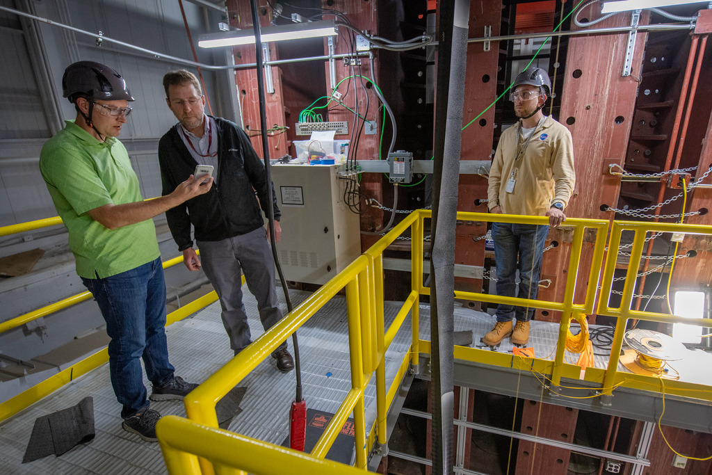
Gravity can create issues when testing materials for space, but Langley researchers have found a way to successfully use gravity and height when testing long composite booms. Testing these composite booms is important because they could support space exploration in a variety of ways, including being used to build structures that could support humans living and working on the Moon.
NASA Imaging Team Supports Missions to Advance Space Exploration, Science A rendering of a space capsule from The Exploration Company re-entering Earth’s atmosphere.Image courtesy of The Exploration Company
A Langley team that specializes in capturing imagery-based engineering datasets from spacecraft during launch and reentry continued its work in 2025, including support of a European aerospace company’s test flight in June. Not only does the team support a variety of missions to advance the agency’s work, but they also collaborate with the private sector as NASA works to open space to more science, people, and opportunities.
NASA Instrument Uses Moonlight for Improved Space Measurements An artist’s rendering of NASA’s Arcstone instrument on-orbit gathering measurements of lunar reflectance.Blue Canyon Technologies
One of the most challenging tasks in remote sensing from space is achieving required instrument calibration on-orbit. Langley scientists are addressing the challenge head on through the Arcstone mission, an instrument that launched in June and aims to establish the Moon as a cost-efficient, high-accuracy calibration reference. Once established, the new standard can be applied to past, present, and future spaceborne sensors and satellite constellations. Arcstone uses a spectrometer, a scientific instrument that measures and analyzes light, to measure lunar spectral reflectance.
NASA Mission Continues Monitoring Air We Breathe By measuring nitrogen dioxide (NO2) and formaldehyde (HCHO), TEMPO can derive the presence of near-surface ozone. On Aug. 2, 2024 over Houston, TEMPO observed exceptionally high ozone levels in the area. On the left, NO2 builds up in the atmosphere over the city and over the Houston Ship Channel. On the right, formaldehyde levels are seen reaching a peak in the early afternoon. Formaldehyde is largely formed through the oxidation of hydrocarbons, an ingredient of ozone production, such as those that can be emitted by petrochemical facilities found in the Houston Ship Channel. NASA’s Scientific Visualization StudioThe success of NASA’s Tropospheric Emissions: Monitoring of Pollution mission, or TEMPO, earned the mission an extension, meaning the work to monitor Earth’s air quality from 22,000 miles above the ground will continue through at least September 2026. The Langley-led mission launched in 2023 and is NASA’s first to use a spectrometer, a scientific instrument that measures and analyzes light, to gather hourly air quality data continuously over North America during daytime hours. The data gathered is distributed freely to the public, giving air quality forecasters, scientists, researchers, and your next-door neighbor access to quality information about the air we breathe down to the neighborhood level.
NASA Tests New, Innovative Tech to Enable Faster Launches at Lower Costs The fully assembled and tested Athena EPIC satellite which incorporates eight HISats mounted on a mock-up of a SpaceX provided launch pedestal which will hold Athena during launch.NovaWurks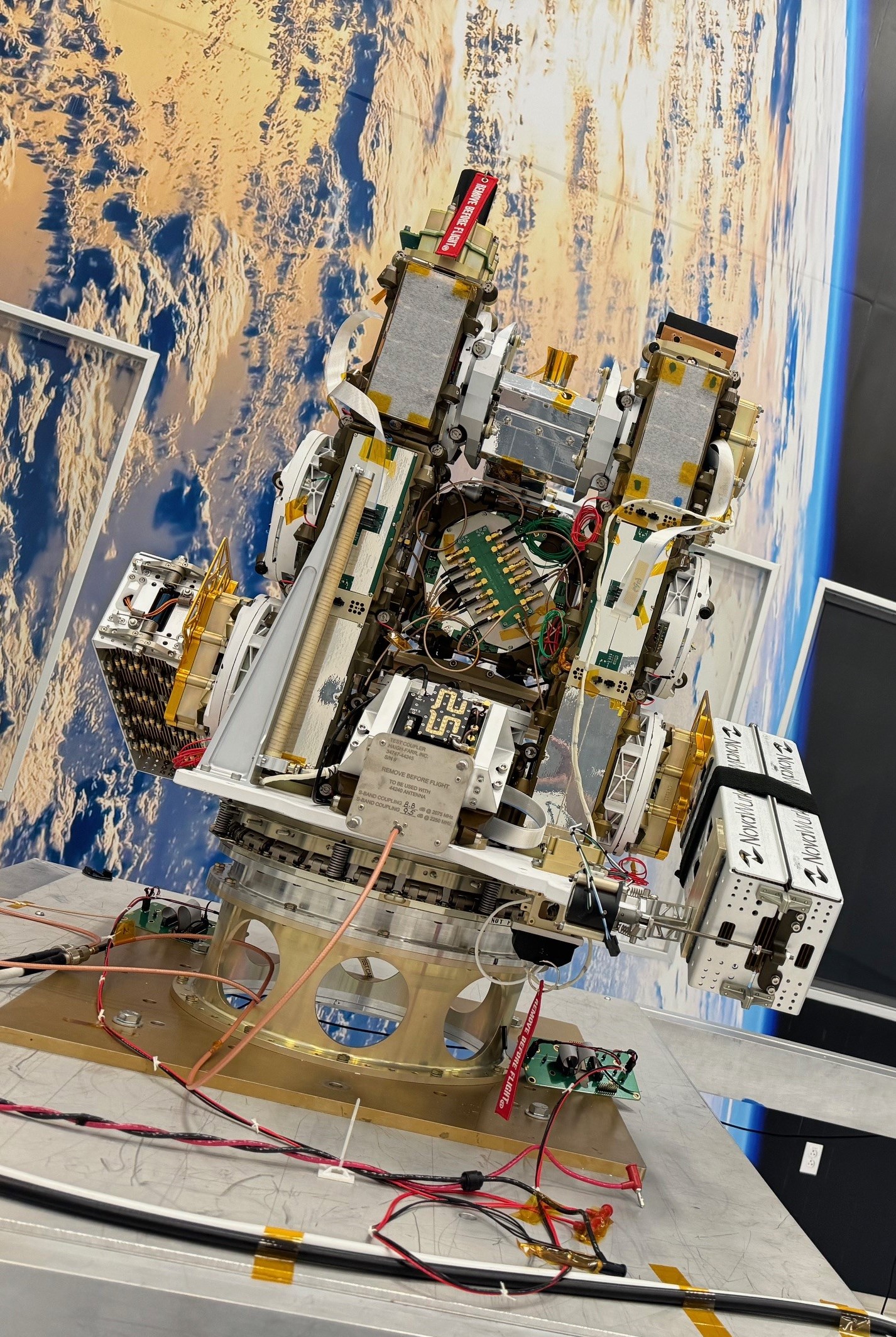
NASA’s Athena Economical Payload Integration Cost mission, or Athena EPIC, launched in July with the goal to shape a future path to launch that saves taxpayers money and expedites access to space. Athena EPIC was the first NASA-led mission led to utilize HISat technology, small satellites engineered to aggregate, share resources, and conform to different sizes and shapes. Langley’s scientists designed and built the Athena sensor with spare parts from NASA’s CERES (Clouds and the Earth’s Radiant Energy System) mission to gather top of atmosphere measurements. Athena EPIC demonstrates a novel way to launch Earth-observing instruments into orbit quicker and more economically.
Drop Test at Langley Offers Research, Data for Potential Air Taxi DesignsThe future of air travel includes the safe integration of drones and air taxis into our airspace for passenger transport, cargo delivery, and public service capabilities. That is why NASA is investigating and testing potential air taxi materials and designs to help the aviation industry better understand how those materials behave under impact. Data collected from a drop test at Langley’s Landing and Impact Research Facility in June will help in the development of safety regulations for advanced air mobility aircraft, leading to safer designs.
Langley Wind Tunnel Tests Help Support Advanced Air Mobility Aircraft Development NASA researcher Norman W. Schaeffler adjusts a propellor, which is part of a 7-foot wing model that was recently tested at NASA’s Langley Research Center in Hampton, Virginia. In May and June, NASA researchers tested the wing in the 14-by-22-Foot Subsonic Wind Tunnel to collect data on critical propeller-wing interactions. The lessons learned will be shared with the public to support advanced air mobility aircraft development.NASA/Mark Knopp
NASA advanced the future of air taxis and autonomous cargo drones by testing a 7-foot wing model in Langley’s 14-by-22-Foot Subsonic Wind Tunnel. This effort produced data on critical propeller-wing interactions, as well as data relevant to cruise, hover, and transition conditions for advanced air mobility aircraft. The results will help validate next-generation design tools and accelerate safe, reliable development across the advanced air mobility industry.
NASA Tests Air Taxi Tech for Future Aircraft Development The Research Aircraft for electric Vertical takeoff and landing Enabling techNologies Subscale Wind Tunnel and Flight Test undergoes a free flight test on the City Environment Range Testing for Autonomous Integrated Navigation range at NASA’s Langley Research Center in Hampton, Virginia on April 22, 2025.NASA/Rob Lorkiewicz
The lack of publicly available engineering and flight data to help address technical barriers in the design and development of new electric vertical takeoff and landing (eVTOL) aircraft is a challenge for researchers and engineers. That is why Langley researchers are using a research aircraft that provides real-world data, obtained through wind tunnel and flight tests, to help fill the information gap and check the accuracy of computer models for flight dynamics and controls. Making this data available to all is a key step in transforming the way we fly and safely integrating new aircraft into our nation’s airspace.
NASA Material Flies High for Study of Long-Term Effects of Space Robert Mosher, HIAD materials and processing lead at NASA Langley, holds up a piece of f webbing material, known as Zylon, which comprise the straps of the HIAD.NASA/Joe Atkinson
A material from NASA Langley is riding high as it orbits the Earth aboard a United States Space Force test vehicle, giving researchers a better understanding of how the material responds to long-duration exposure to the harsh vacuum of space. The strap material is a part of a Langley-developed aeroshell to protect spacecraft re-entering Earth’s atmosphere or to ensure their safe landing on other celestial bodies, such as Mars. Understanding how extended exposure to space affects the material is important as NASA prepares to send humans beyond the Moon.
NASA Flights Study Impacts of Space Weather on Travelers Frozen and rocky terrain in the Polar region observed from above Nuuk, Greenland during NASA’s SWXRAD science flights.NASA/Guillaume Gronoff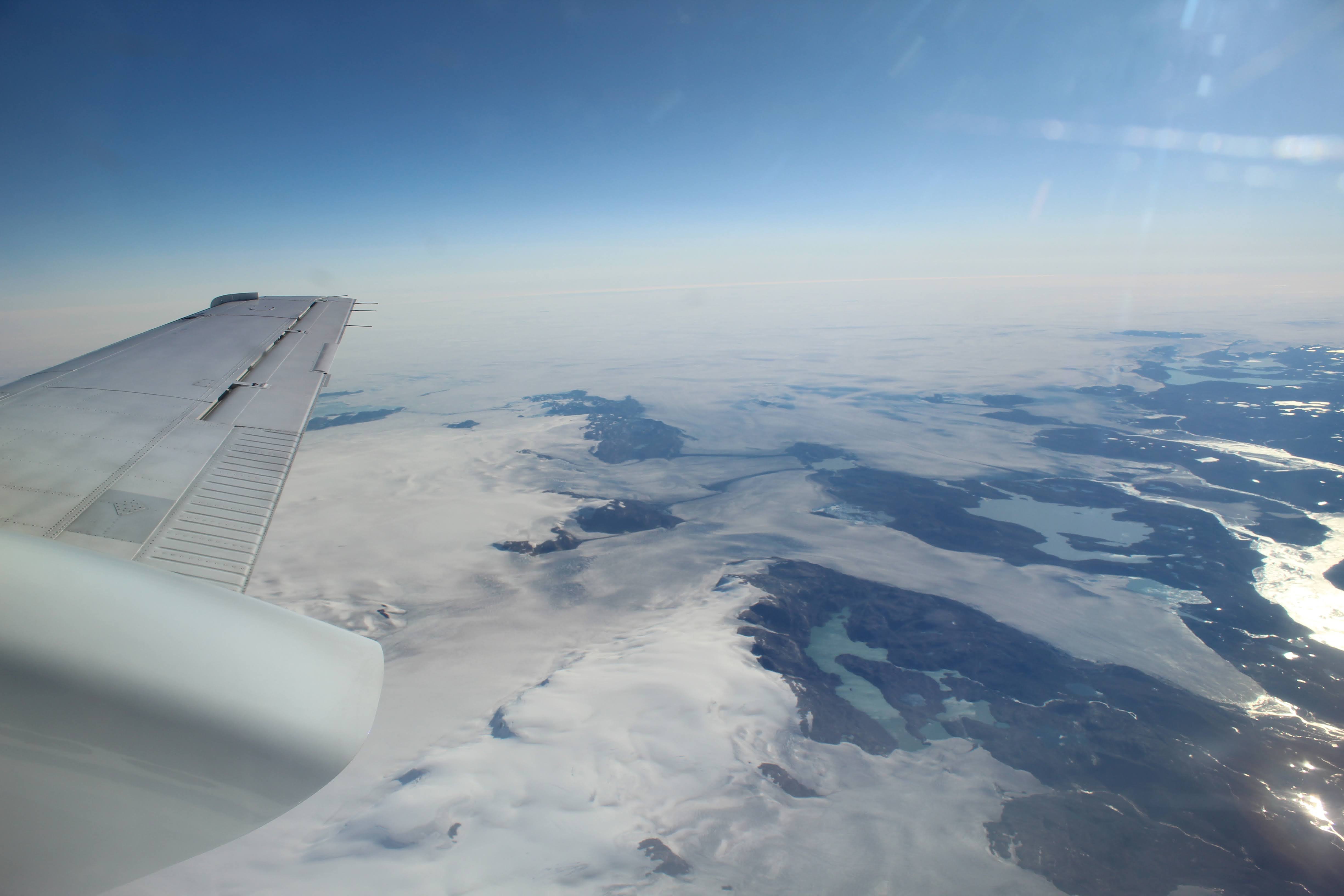
Data gathered during a Langley-led airborne science campaign late this summer could help protect air travelers on Earth and future space travelers to the Moon, Mars, and beyond from the health risks associated with radiation exposure. NASA’s Space Weather Aviation Radiation (SWXRAD) aircraft flight campaign took place in Greenland and measured the radiation dose level to air travelers from cosmic radiation. Researchers are using the information to enhance a modeling system that offers real-time global maps of the hazardous radiation in the atmosphere and creates exposure predictions for aircraft and spacecraft.
NASA’s Dragonfly Completes Wind Tunnel Tests at Langley Set up and testing of Dragonfly model in the Transonic Dynamics TunnelNASA/David C. Bowman
As NASA returns astronauts to the Moon through the Artemis campaign in preparation for human exploration of Mars, the agency also has its sights set on Saturn, specifically Saturn’s moon Titan. NASA’s Dragonfly, a car-sized rotorcraft set to launch no earlier than 2028, will explore Titan and try to discover how life began. This fall, engineers placed a full-scale test model representing half of the Dragonfly lander in Langley’s Transonic Dynamics Tunnel to evaluate how its rotor system performed in Titan-like conditions. The data will be integral in developing the rotorcraft’s flight plans and navigation software as it investigates multiple landing sites on Titan.
NASA Offers Science, Technology, and Expertise During Disaster Response True color imagery of Hurricane Milton on Oct. 7, 2024, from the NOAA-21 satellite. NASA / NOAA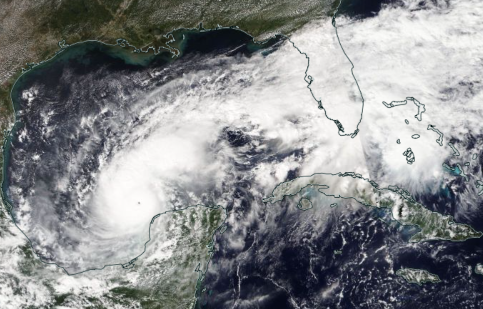
In response to severe weather that impacted more than 10 states in November, the NASA Disasters Response Coordination System (DRCS) activated to support national partners. The DRCS is headquartered at Langley. NASA worked closely with the National Weather Service and the Federal Emergency Management Agency serving the central and southeastern U.S. to provide satellite data and expertise that help communities better prepare, respond, and recover.
NASA’s X-59 Takes FlightIn October, NASA’s Quesst mission celebrated a major milestone – the X-59 quiet supersonic one-of-a-kind research aircraft flew for the first time, a historic moment for aviation. The hard work, talent, and innovation of NASA engineers and project team members, including many based at NASA Langley, made this achievement possible. One of the notable traits of the X-59 is the eXternal Vision System (XVS) which allows the test pilots to safely maneuver the skies without a forward-facing window. This unique supersonic design feature was developed and tested at NASA Langley.
The X-59’s first flight was a major step toward quiet supersonic flight over land, which could revolutionize air travel.
What a Blast! Langley Begins Plume-Surface Interaction Tests Views of the 60-foot vacuum sphere in the which the plume-surface interaction testing is happening.NASA/Joe Atkinson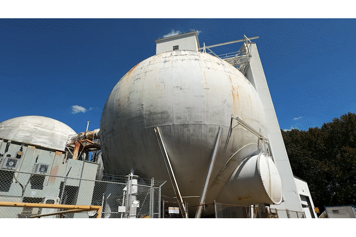
A team at NASA Langley is firing engine plumes into simulated lunar soil because as the United States returns to the Moon, both through NASA’s Artemis campaign and the commercialization of space, researchers need to understand the hazards that may occur when a lander’s engines blast away at the lunar dust, soil, and rocks.
Langley Inspires Through Community Engagement, Educational Opportunities NASA Langley highlights its Cirrus Design SR22 during Air Power Over Hampton Roads STEM Day. NASA/Angelique Herring
Langley connected with communities across Virginia and beyond to share the center’s work and impact, and inspire the next generation of explorers, scientists, and researchers. Thousands of spectators enjoyed hands-on activities and exhibits during the Air Power over Hampton Roads air show at Joint Base Langley-Eustis in Hampton, Virginia, where NASA Langley’s aviation past, present, and future were on full display. More than 2,300 students from across the nation eagerly participated in Langley’s 2025 Student Art Contest, and shared their artistic spin on the theme, “Our Wonder Changes the World.” Langley and Embry-Riddle Aeronautical University announced an agreement in September that will leverage Langley’s aerospace expertise and Embry-Riddle’s specialized educational programs and research to drive innovation in aerospace, research, education, and technology, while simultaneously developing a highly skilled workforce for the future of space exploration and advanced air mobility.
Langley looks forward to another year of successes and advancements in 2026, as we continue to make the seemingly impossible, possible.
Share Details Last Updated Dec 17, 2025 Related Terms Explore More 2 min read NextSTEP-3 B: Moon to Mars Architecture Studies Article 2 days ago 6 min read Retirement Article 1 week ago 2 min read NASA Demonstrates Safer Skies for Future Urban Air Travel Article 1 week agoA Siberian Snowman in Billings
- Earth
- Earth Observatory
- Image of the Day
- EO Explorer
- Topics
- More Content
- About
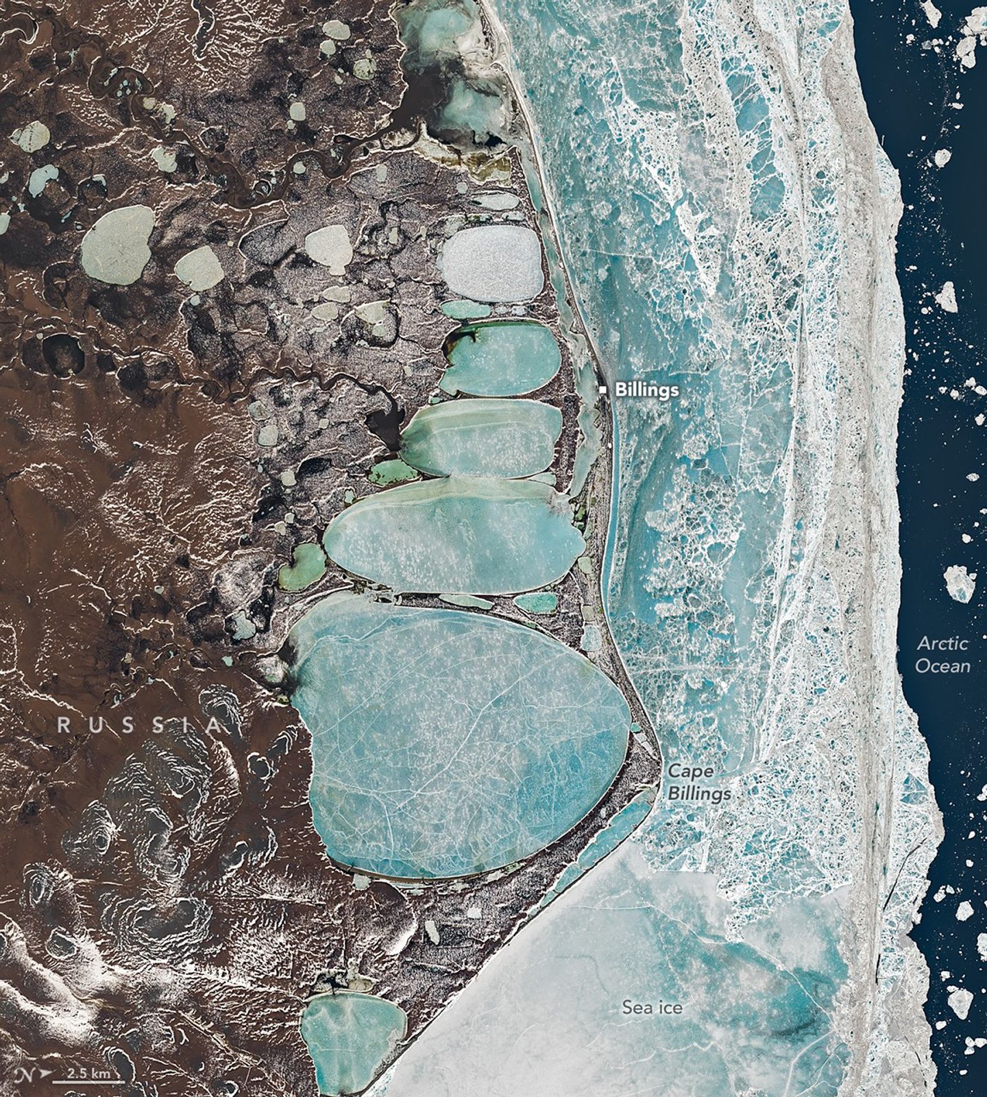
Icons of winter are sometimes found in unexpected places. In one striking example, a series of oval lagoons in a remote part of Siberia forms the shape of a towering snowman when viewed from above.
This image, centered on the remote village of Billings and nearby Cape Billings on Russia’s Chukchi Peninsula, was captured by the OLI (Operational Land Imager) aboard Landsat 8 on June 16, 2025. Established in the 1930s as a port and supply point for the Soviet Union, the village sits on a narrow sandspit that separates the Arctic Ocean from a series of connected coastal inshore lagoons.
The elongated, oval lagoons are frozen over and flanked by sea ice. Though June is one of the warmest months in Billings, ice cover is routine even then. Mean daily minimum temperatures are just minus 0.6 degrees Celsius (30.9 degrees Fahrenheit) in June, according to meteorological data.
Though the shape may seem engineered, it is natural and the product of geological processes common in the far north. The ground in this part of Siberia is frozen most of the year and pockmarked with spear-shaped ice wedges buried under the surface. Summer melting causes overlying soil to slump, leaving shallow depressions that fill with meltwater and form thermokarst lakes. Once created, consistency in the direction of the winds and waves likely aligned and elongated the lakes into the shapes seen in the image. The thin ridges separating the lakes may represent the edges of different ice wedges below the surface.
The first reference to humans building snowmen dates back to the Middle Ages, according to the book The History of the Snowman. While three spherical segments are the most common form, other variants dominate in certain areas. In Japan, snowmen typically have just two segments and are rarely given arms. This five-segmented snowman-shaped series of lakes spans about 22 kilometers (14 miles) from top to bottom, making it roughly 600 times longer than the actual snowwoman that held the Guinness record for being the world’s tallest snowperson in 2025.
Snowmen are not the only winter icons tied to this remote landscape. For early expeditions to the Russian Arctic, reindeer offered one of the most reliable modes of transportation. That includes expeditions by the town’s namesake, Commodore Joseph Billings, a British-born naval officer who enlisted in the Russian navy and led a surveying expedition to find a Northeast Passage between 1790 and 1794.
Although the hundred-plus members of the expedition did not reach Cape Billings, they explored much of the Chukchi Peninsula, producing some of the first accurate maps and further confirming that Asia and North America were separated by a strait. In the winter months, when their ships were beset by ice, the explorers moved to temporary camps on land and instead surveyed the region with reindeer-drawn wooden sleds, according to historical accounts. Winters, in fact, offered the best conditions for exploration because the peninsula’s many rivers and lakes turned into solid surfaces that were easy to traverse in comparison to the muddy bogs that open up in the summer.
Indigenous Chukchi people living on the peninsula at the time routinely used reindeer to haul both people and cargo. A pair of reindeer can comfortably haul hundreds of pounds for several hours a day. In addition to their impressive endurance in cold temperatures, reindeer largely feed themselves by digging through snow and grazing on lichens, something that neither sled dogs nor horses can do.
Historical documents indicate that the Billings expedition enlisted Chukchi people to manage and care for the reindeer they used, with some accounts suggesting that the explorers used dozens of reindeer at times. While reindeer were mainly used to haul sleds, Chukchi people likely rode them as well.
Non-Chukchi members of the expedition reportedly experimented with riding reindeer, though their experiments did not always go smoothly. Billings’ secretary and translator Martin Sauer reported using a saddle without stirrups or a bridle and falling “nearly 20 times” after about three hours of travel in his account of the expedition. Not only that, he added, but the saddle “at first, causes astonishing pain to the thighs.”
NASA Earth Observatory image by Michala Garrison, using Landsat data from the U.S. Geological Survey. Story by Adam Voiland.
References & Resources- Alekseev, A.I. (1966) Joseph Billings. The Geographical Journal, 132(2), 233-238.
- Arctic Portal Chukchi. Accessed December 16, 2025.
- Astronomy (2019, January 2) Ultima Thule emerges as contact binary, “cosmic snowman,” in new spacecraft images. Accessed December 16, 2025.
- Chlenov, M. (2006) The “Uelenski Language” and its Position Among Native Languages of the Chukchi Peninsula. Alaska Journal of Anthropology, 4(1-2), 74-91.
- Dokuchaev, A., et al. (2022) The First Scientific Expeditions to the Bering Strait and to the Russian Colonies in America. Arctic and North, 48, 179-208.
- Eckstein, B., via Internet Archive (2007) The history of the snowman. Simon & Schuster: New York. Accessed December 16, 2025.
- Hobden, H. Yakutia in the 18th century – The Great Scientific Expeditions – Part Two. Accessed December 16, 2025.
- Klokov, K.B. (2023) Geographical variability and cultural diversity of reindeer pastoralism in northern Russia: delimitation of areas with different types of reindeer husbandry. Pastoralism, 13, 15.
- Krylenko, V. (2017) Estuaries and Lagoons of the Russian Arctic Seas. Estuaries of the World, Springer: Cham, 13-15.
- NASA (2012) Views of the Snowman. Accessed December 16, 2025.
- Obscure Histories (2022, December 20) The Snowman: A brief history of a winter entertainment. Accessed December 16, 2025.
- Radio Free Europe (2015, March 10) The Village At The End Of The Earth. Accessed December 16, 2025.
- Sauer, M., via Internet Archive (1802) An account of a geographical and astronomical expedition to the northern parts of Russia. Strahan: London. Accessed December 16, 2025.
- Zonn, I., et al. (2016) Shores of the Chukchi Sea. The Eastern Arctic Seas Encyclopedia, 298-301.
JPEG (9.74 MB)
You may also be interested in:
Stay up-to-date with the latest content from NASA as we explore the universe and discover more about our home planet.
Arctic Sea Ice Ties for 10th-Lowest on Record
3 min read
Satellite data show that Arctic sea ice likely reached its annual minimum extent on September 10, 2025.
ArticleAntarctic Sea Ice Saw Its Third-Lowest Maximum
2 min read
Sea ice around the southernmost continent hit one of its lowest seasonal highs since the start of the satellite record.
ArticleGreenland Ice Sheet Gets a Refresh
3 min read
A moderately intense season of surface melting left part of the ice sheet dirty gray in summer 2025, but snowfall…
Article1
2
3
4
Next
Keep Exploring Discover More from NASA Earth Science Subscribe to Earth Observatory Newsletters
Subscribe to the Earth Observatory and get the Earth in your inbox.
Earth Observatory Image of the Day
NASA’s Earth Observatory brings you the Earth, every day, with in-depth stories and stunning imagery.
Explore Earth Science
Earth Science Data