
Feed aggregator
What Time Is It on Mars?
Precisely calibrating clocks on Mars is harder than you’d think, because of some extremely esoteric physics
AI as the New Empire? Karen Hao Explains the Hidden Costs of OpenAI’s Ambitions
Journalist Karen Hao unpacks the rise of AI “empires,” their ideological roots, and the hidden environmental and societal costs of OpenAI’s quest for artificial general intelligence.
This Week's Sky at a Glance, December 12 – 21
Big Jupiter now rises in the east-southeast less than an hour after dark. It's high in sharp telescopic viewing by about 10 p.m.
The post This Week's Sky at a Glance, December 12 – 21 appeared first on Sky & Telescope.
Earth from Space: Pariacaca Mountain Range, Peru
Qubits break quantum limit to encode information for longer
Qubits break quantum limit to encode information for longer
Pacific Moisture Drenches the U.S. Northwest
- Earth
- Earth Observatory
- Image of the Day
- EO Explorer
- Topics
- More Content
- About
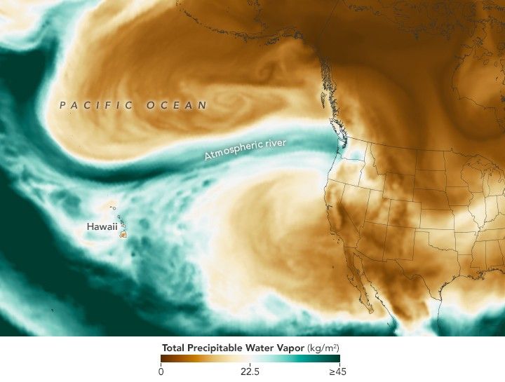
Waves of heavy rainfall in early December 2025 spurred landslides and flooding in parts of the Pacific Northwest. The deluge was the result of a potent atmospheric river that took aim at the region starting around December 7.
Atmospheric rivers are long, narrow bands of moisture that move like rivers in the sky, transporting water vapor from the tropics toward the poles. They occur around the planet, most often in autumn and winter, with the U.S. West Coast typically affected by moist air that originates near Hawaii. In this event, however, some of the moisture arrived from even farther away, originating roughly 7,000 miles (11,000 kilometers) across the Pacific from near the Philippines.
This map shows the total precipitable water vapor in the atmosphere at 11:30 p.m. Pacific Time on December 10. It is derived from NASA’s GEOS (Goddard Earth Observing System) and uses satellite data and models of physical processes to approximate what is happening in the atmosphere.
Precipitable water vapor represents the amount of water contained in a column of air, assuming all the water vapor condensed into liquid. The map’s green areas indicate the highest amounts of moisture. Note that not all precipitable water vapor falls as rain; at least some remains in the atmosphere. Nor is it a cap on how much rain can fall, since rainfall can increase as more moisture flows into a column of air. Still, it serves as a useful indicator of areas where excessive rainfall is likely.
According to the National Weather Service, preliminary ground-based measurements showed that several locations in western Washington received more than 10 inches (250 millimeters) of rain over a 72-hour period ending on the morning of December 11. Seattle-Tacoma International Airport set a daily rainfall record on December 10, with 1.6 inches (40 millimeters).
River flooding was ongoing on December 11, with the Skagit River and Snohomish River seeing record or near-record flood levels that day. Floodwater and mudslides have closed numerous roadways, including the eastbound lanes of I-90 out of western Washington.
NASA’s Disasters Response Coordination System has been activated to support the ongoing response efforts by the Washington State Emergency Operations Center. The team will be posting maps and data products on its open-access mapping portal as new information becomes available.
NASA Earth Observatory images by Lauren Dauphin, using GEOS data from the Global Modeling and Assimilation Office at NASA GSFC. Story by Kathryn Hansen.
References & Resources- Cliff Mass Weather Blog (2025, December 8) The Torrent Has Begun: The Philippine Connection. Accessed December 11, 2025.
- National Water Center, via X (2025, December 10) Key Messages for Pacific Northwest Flooding. Accessed December 11, 2025.
- National Weather Service (2025, December 11) Miscellaneous Hydrological Data. Accessed December 11, 2025.
- NOAA (2025, February 21) What are atmospheric rivers? Accessed December 11, 2025.
- USA Today (2025, December 11) Catastrophic flooding sparks evacuations in Washington state. See forecast. Accessed December 11, 2025.
- The Washington Post (2025, December 8) A 7,000-mile atmospheric river is stretching from Philippines to the U.S. Accessed December 11, 2025.
JPEG (1.55 MB)
You may also be interested in:
Stay up-to-date with the latest content from NASA as we explore the universe and discover more about our home planet.
Iraq Reservoirs Plunge to Low Levels
5 min read
A multi-year drought has put extra strain on farmers and water managers in the Middle Eastern country.
ArticleDrought Parches the Yakima River Basin
4 min read
Farmers are facing the burden of dwindling reservoir water in this productive agricultural region of Washington state.
ArticleReservoirs Dwindle in South Texas
3 min read
Drought in the Nueces River basin is reducing reservoir levels, leaving residents and industry in the Corpus Christi area facing…
Article1
2
3
4
Next
Keep Exploring Discover More from NASA Earth Science Subscribe to Earth Observatory Newsletters
Subscribe to the Earth Observatory and get the Earth in your inbox.
Earth Observatory Image of the Day
NASA’s Earth Observatory brings you the Earth, every day, with in-depth stories and stunning imagery.
Explore Earth Science
Earth Science Data
Pacific Moisture Drenches the U.S. Northwest
- Earth
- Earth Observatory
- Image of the Day
- EO Explorer
- Topics
- More Content
- About
Waves of heavy rainfall in early December 2025 spurred landslides and flooding in parts of the Pacific Northwest. The deluge was the result of a potent atmospheric river that took aim at the region starting around December 7.
Atmospheric rivers are long, narrow bands of moisture that move like rivers in the sky, transporting water vapor from the tropics toward the poles. They occur around the planet, most often in autumn and winter, with the U.S. West Coast typically affected by moist air that originates near Hawaii. In this event, however, some of the moisture arrived from even farther away, originating roughly 7,000 miles (11,000 kilometers) across the Pacific from near the Philippines.
This map shows the total precipitable water vapor in the atmosphere at 11:30 p.m. Pacific Time on December 10. It is derived from NASA’s GEOS (Goddard Earth Observing System) and uses satellite data and models of physical processes to approximate what is happening in the atmosphere.
Precipitable water vapor represents the amount of water contained in a column of air, assuming all the water vapor condensed into liquid. The map’s green areas indicate the highest amounts of moisture. Note that not all precipitable water vapor falls as rain; at least some remains in the atmosphere. Nor is it a cap on how much rain can fall, since rainfall can increase as more moisture flows into a column of air. Still, it serves as a useful indicator of areas where excessive rainfall is likely.
According to the National Weather Service, preliminary ground-based measurements showed that several locations in western Washington received more than 10 inches (250 millimeters) of rain over a 72-hour period ending on the morning of December 11. Seattle-Tacoma International Airport set a daily rainfall record on December 10, with 1.6 inches (40 millimeters).
River flooding was ongoing on December 11, with the Skagit River and Snohomish River seeing record or near-record flood levels that day. Floodwater and mudslides have closed numerous roadways, including the eastbound lanes of I-90 out of western Washington.
NASA’s Disasters Response Coordination System has been activated to support the ongoing response efforts by the Washington State Emergency Operations Center. The team will be posting maps and data products on its open-access mapping portal as new information becomes available.
NASA Earth Observatory images by Lauren Dauphin, using GEOS data from the Global Modeling and Assimilation Office at NASA GSFC. Story by Kathryn Hansen.
References & Resources- Cliff Mass Weather Blog (2025, December 8) The Torrent Has Begun: The Philippine Connection. Accessed December 11, 2025.
- National Water Center, via X (2025, December 10) Key Messages for Pacific Northwest Flooding. Accessed December 11, 2025.
- National Weather Service (2025, December 11) Miscellaneous Hydrological Data. Accessed December 11, 2025.
- NOAA (2025, February 21) What are atmospheric rivers? Accessed December 11, 2025.
- USA Today (2025, December 11) Catastrophic flooding sparks evacuations in Washington state. See forecast. Accessed December 11, 2025.
- The Washington Post (2025, December 8) A 7,000-mile atmospheric river is stretching from Philippines to the U.S. Accessed December 11, 2025.
JPEG (1.55 MB)
You may also be interested in:
Stay up-to-date with the latest content from NASA as we explore the universe and discover more about our home planet.
Iraq Reservoirs Plunge to Low Levels
5 min read
A multi-year drought has put extra strain on farmers and water managers in the Middle Eastern country.
ArticleDrought Parches the Yakima River Basin
4 min read
Farmers are facing the burden of dwindling reservoir water in this productive agricultural region of Washington state.
ArticleReservoirs Dwindle in South Texas
3 min read
Drought in the Nueces River basin is reducing reservoir levels, leaving residents and industry in the Corpus Christi area facing…
Article1
2
3
4
Next
Keep Exploring Discover More from NASA Earth Science Subscribe to Earth Observatory Newsletters
Subscribe to the Earth Observatory and get the Earth in your inbox.
Earth Observatory Image of the Day
NASA’s Earth Observatory brings you the Earth, every day, with in-depth stories and stunning imagery.
Explore Earth Science
Earth Science Data
Lake-Star Analog for Europa’s Manannán Spider
What geological features on Earth can be used to better understand unique geological features on Jupiter’s icy moon, Europa? This is what a recent study published in The Planetary Science Journal hopes to address as a team of researchers investigated potential Earth analogs for studying a unique geological feature on Europa scientists identified almost 30 years ago. This study has the potential help scientists gain insights into Europa’s unique geological features, some of which scientists hypothesize are caused by the moon’s internal liquid water ocean.
New antibiotic could stave off drug-resistant gonorrhoea
New antibiotic could stave off drug-resistant gonorrhoea
Did Life Begin in Prebiotic Surface Gels?
Surface-bound gels may have provided the structure and chemistry necessary for life to take root on Earth. These findings could also have implications in the search for life beyond Earth.
NASA Selects Two Heliophysics Missions for Continued Development
NASA has selected one small explorer mission concept to advance toward flight design and another for an extended period of concept development.
NASA’s Science Mission Directorate Science Management Council selected CINEMA (Cross-scale Investigation of Earth’s Magnetotail and Aurora) to enter Phase B of development, which includes planning and design for flight and mission operations. The principal investigator for the CINEMA mission concept is Robyn Millan from Dartmouth College in Hanover, New Hampshire.
The proposed CINEMA mission aims to advance our understanding of how plasma energy flows into the Earth’s magnetosphere. This highly dynamic convective flow is unpredictable — sometimes steady and sometimes explosive — driving phenomena like fast plasma jets, global electrical current systems, and spectacular auroral displays.
“The CINEMA mission will help us to research magnetic convection in Earth’s magnetosphere — a critical piece of the puzzle in understanding why some space weather events are so influential, such as causing magnificent aurora displays and impacts to ground- and space-based infrastructure, and others seem to fizzle out,” said Joe Westlake, director of the Heliophysics Division at NASA Headquarters in Washington. “Using multiple, multi-point measurements to improve predictions of these impacts on humans and technology across the solar system is a key strategy for the future of heliophysics research.”
The CINEMA mission’s constellation of nine small satellites will investigate the convective mystery using a combination of instruments — an energetic particle detector, an auroral imager, and a magnetometer — on each spacecraft in a polar low Earth orbit. By relating the energetic particles observed in this orbit to simultaneous auroral images and local magnetic field measurements, CINEMA aims to connect energetic activity in Earth’s large-scale magnetic structure to the visible signatures like aurora that we see in the ionosphere. The mission has been awarded approximately $28 million to enter Phase B. The total cost of the mission, not including launch, will not exceed $182.8 million. Phase B will last 10 months, and if selected, the mission would launch no earlier than 2030.
NASA also selected the proposed CMEx (Chromospheric Magnetism Explorer) mission for an extended Phase A study. This extended phase is for the mission to assess and refine their design for potential future consideration. The principal investigator for the CMEx mission concept study is Holly Gilbert from the National Center for Atmospheric Research in Boulder, Colorado. The cost of the extended Phase A, which will last 12 months, is $2 million.
The CMEx concept is a proposed single-spacecraft mission that would use proven UV spectropolarimetric instrumentation that has been demonstrated during NASA’s CLASP (Chromospheric Layer Spectropolarimeter) sub-orbital sounding rocket flight. Using this heritage hardware, CMEx would be able to diagnose lower layers of the Sun’s chromosphere to understand the origin of solar eruptions and determine the magnetic sources of the solar wind.
The proposed missions completed a one-year early concept study in response to the 2022 Heliophysics Explorers Program Small-class Explorer (SMEX) Announcement of Opportunity.
“Space is becoming increasingly more important and plays a role in just about everything we do,” said Asal Naseri, acting associate flight director for heliophysics at NASA Headquarters. “These mission concepts, if advanced to flight, will improve our ability to predict solar events that could harm satellites that we rely on every day and mitigate danger to astronauts near Earth, at the Moon, or Mars.”
To learn more about NASA heliophysics missions, visit:
https://science.nasa.gov/heliophysics
-end-
Abbey Interrante / Karen Fox
Headquarters, Washington
301-201-0124 / 202-358-1600
abbey.a.interrante@nasa.gov / karen.c.fox@nasa.gov
COVID Vaccines Slashed Kids’ ER Visits by 76 Percent, Study Finds
A report published by the CDC reaffirms the effectiveness of COVID vaccines at preventing severe disease in children
Webb’s First Look at TRAPPIST-1e Hints at a Titan-like Atmosphere
Observations from the James Webb Space Telescope suggest the planet might have a nitrogen-and-methane atmosphere — but more data are needed to rule out a bare rock scenario.
The post Webb’s First Look at TRAPPIST-1e Hints at a Titan-like Atmosphere appeared first on Sky & Telescope.
A New Five-Year Survey Of The Magellanic Clouds Will Answer Some Questions About Our Neighbours
The Leibniz Institute for Astrophysics Potsdam (AIP) is forming a new research group that will focus solely on the Large and Small Magellanic Clouds. The pair of irregular dwarf galaxies are satellites of the Milky Way, and are natural, nearby laboratories for studying how galaxies form and evolve. The research group will make heavy use of the spectroscopic 4MOST survey from the VISTA telescope.
U.S. Approves First Device to Treat Depression with Brain Stimulation at Home
The FDA has approved a device that aims to treat depression by sending electric current into a part of the brain known to regulate mood