
Feed aggregator
ESA Open Days 2025
ESA Open Days 2025
Your chance to meet the European Space Agency
Repeated Heat Waves Can Age You as Much as Smoking or Drinking
A new long-term study suggests that the more heat waves people are exposed to, the more their body’s aging process accelerates
Reaching Out
This image released on Aug. 20, 2025, combines new radio data from the Australia Telescope Compact Array with X-ray data from NASA’s Chandra X-ray Observatory. Chandra first released an image of this pulsar and its surrounding hand-shaped nebula in 2009. The new data provides a fresh view of this exploded star and its environment, which could help scientists understand its peculiar properties and shape.
Image credit: X-ray: NASA/CXC/Univ. of Hong Kong/S. Zhang et al.; Radio: ATNF/CSIRO/ATCA; H-alpha: UK STFC/Royal Observatory Edinburgh; Image Processing: NASA/CXC/SAO/N. Wolk
Exoplanets engulfed in steam are taking center stage in the search for life in our galaxy
Inside the revolutionary idea that we can negotiate with cancer
Inside the revolutionary idea that we can negotiate with cancer
Relive SpaceX's nighttime launch of the X-37B space plane with these dazzling photos
Weird X-ray Flashes Lose Some of Their Mystery
Some fast X-ray transients — quick flashes of energetic radiation — may come from massive stars collapsing and exploding at the same time.
The post Weird X-ray Flashes Lose Some of Their Mystery appeared first on Sky & Telescope.
JWST gets a closer look at interstellar comet 3I/ATLAS
JWST gets a closer look at interstellar comet 3I/ATLAS
James Webb Space Telescope takes 1st look at interstellar comet 3I/ATLAS with unexpected results
NASA Test Deploys Roman Space Telescope Solar Panels, ‘Visor’
On Aug. 7 and 8, NASA’s Nancy Grace Roman Space Telescope team assessed the observatory’s solar panels and a visor-like sunshade called the deployable aperture cover — two components that will be stowed for launch and unfold in space. Engineers confirmed their successful operation during a closely monitored sequence in simulated space-like conditions. On the first day, Roman’s four outer solar panels were deployed one at a time, each unfolding over 30 seconds with 30-second pauses between them. The visor followed in a separate test the next day. These assessments help ensure Roman will perform as expected in space. Roman is slated to launch no later than May 2027, with the team working toward a potential early launch as soon as fall 2026.
Click here to learn more about Roman Share Details Last Updated Aug 26, 2025 EditorAshley BalzerContactAshley Balzerashley.m.balzer@nasa.gov Related TermsNASA Stennis Provides Ideal Setting for Range Operations
Think of NASA’s Stennis Space Center, and one likely thinks of rocket propulsion testing. The site has a long history of testing to support the nation’s space efforts, including the current Artemis program to send astronauts to the Moon to prepare for future human exploration of Mars.
However, NASA Stennis also is working to become a key supporter of more terrestrial exploration. Indeed, in terms of unmanned range operations, NASA Stennis has it all – layers of restricted airspace, a closed canal system, and acres upon acres of protected terrain.
Field TestU.S. Naval Research Laboratory personnel conduct a field experiment involving an unmanned aerial system at NASA Stennis in March 2024. (NASA/Danny Nowlin)NASA/Danny Nowlin Marine OperationU.S. Naval Research laboratory personnel conduct tests on The Blue Boat made by Blue Robotics, an unmanned surface vessel, at NOAA’s National Data Buoy Center basin at NASA Stennis on Dec. 19, 2024.NASA/Danny Nowlin Bird’s-Eye ViewAn unmanned aerial system provides a bird’s-eye view of an RS-25 on Feb. 22, 2024, on the Fred Haise Test Stand at NASA Stennis. NASAThe NASA site near Bay St. Louis, Mississippi, is an ideal location for all types of air, marine, and ground testing, said Range Operations Manager Jason Peterson. “My job is to understand the customer, and their requirements and limitations, to help them succeed,” he added. “What makes NASA Stennis unique is our federally protected area for users to operate.”
The need to learn about unmanned systems, such as drones or underwater vehicles, in a safe environment is growing as technology advances. Think of it like learning to drive a car in a parking lot before hitting the road.
NASA Stennis has already begun leveraging these capabilities. In 2024, the center established an agreement with Skydweller Aero Inc. to utilize restricted airspace for flight testing of autonomous, solar-powered aircraft. This first-of-its-kind agreement paves the way for future collaborations as NASA Stennis expands its customer-based operations beyond onsite tenants.
An unmanned aerial system provides a panoramic view of the NASA Stennis test complex and canal system. NASA Look to the Sky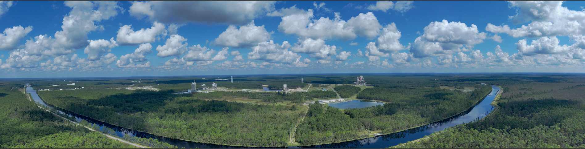
NASA Stennis has its own protected airspace, similar to how airports control the skies around them. The Federal Aviation Administration (FAA) first established this restricted airspace in 1966 and expanded it in 2016 to support both NASA missions and U.S. Department of Defense operations.
NASA Stennis is one of only two non-military restricted airspaces in the nation. It operates two main airspace zones – a propulsion testing area extending from ground level up to 12,000 feet for safely testing rocket engines without interfering with regular air traffic, and an aircraft operations zone covering 100 square miles up to 6,000 feet, with 15 dedicated acres for drone launch and recovery.
NASA Stennis staff provide comprehensive support including safety reviews, coordination between aircraft operators and FAA air traffic controllers, and constant communication with range safety personnel to ensure all operations are conducted safely.
Marine OperationsThe centerpiece of the NASA Stennis marine range is its extensive 7.5-mile canal system, protected by a lock-and-dam system that connects to Pearl River tributaries. This network accommodates various marine platforms including traditional watercraft, autonomous underwater vehicles, remotely operated vehicles, unmanned surface vessels, and aerial drones requiring water landing capabilities.
The controlled environment provides protection from adverse weather and interference, making it ideal for testing sensitive or proprietary technologies. The facility is particularly valuable for emerging technologies in autonomous systems, sensor integration, and multi-domain operations where air, surface, and underwater platforms operate in coordination.
Ground LevelNASA Stennis facilities are located on 13,800 acres of fenced-in property, surrounded by an additional 125,000 acres of protected land known as the acoustical buffer zone. This area was established primarily through permanent lease to allow testing of large rocket hardware without disturbing area residents and is closely monitored without permanent habitable structures.
“The location helps reduce hazards to the public when testing new technology,” Peterson said. “With supporting infrastructure for office space, storage, or manufacturing, this makes NASA Stennis a great place to test, train, operate, and even manufacture.”
The NASA Stennis federal city already hosts more than 50 federal, state, academic, public, and private aerospace, technology, and research organizations, with room for more. All tenants share operating costs while pursuing individual missions.
‘Open for Business’NASA Stennis leaders are keenly aware of the opportunity such unique capabilities afford. The center’s 2024-2028 strategic plan states NASA Stennis will leverage these unique capabilities to support testing and operation of uncrewed systems.
Leaders are working to identify opportunities to maximize site capabilities and develop an effective business model. “NASA Stennis is open for business, and we want to provide a user-friendly range for operators to test vehicles by creating an environment that is safe, cost-effective, and focused on mission success,” Peterson said.
For information about range operations at NASA’s Stennis Space Center, visit:
Range and Airspace Operations – NASA
For information about Stennis Space Center, visit:
https://www.nasa.gov/stennis
NASA Stennis Provides Ideal Setting for Range Operations
Think of NASA’s Stennis Space Center, and one likely thinks of rocket propulsion testing. The site has a long history of testing to support the nation’s space efforts, including the current Artemis program to send astronauts to the Moon to prepare for future human exploration of Mars.
However, NASA Stennis also is working to become a key supporter of more terrestrial exploration. Indeed, in terms of unmanned range operations, NASA Stennis has it all – layers of restricted airspace, a closed canal system, and acres upon acres of protected terrain.
Field TestU.S. Naval Research Laboratory personnel conduct a field experiment involving an unmanned aerial system at NASA Stennis in March 2024. (NASA/Danny Nowlin)NASA/Danny Nowlin Marine OperationU.S. Naval Research laboratory personnel conduct tests on The Blue Boat made by Blue Robotics, an unmanned surface vessel, at NOAA’s National Data Buoy Center basin at NASA Stennis on Dec. 19, 2024.NASA/Danny Nowlin Bird’s-Eye ViewAn unmanned aerial system provides a bird’s-eye view of an RS-25 on Feb. 22, 2024, on the Fred Haise Test Stand at NASA Stennis. NASAThe NASA site near Bay St. Louis, Mississippi, is an ideal location for all types of air, marine, and ground testing, said Range Operations Manager Jason Peterson. “My job is to understand the customer, and their requirements and limitations, to help them succeed,” he added. “What makes NASA Stennis unique is our federally protected area for users to operate.”
The need to learn about unmanned systems, such as drones or underwater vehicles, in a safe environment is growing as technology advances. Think of it like learning to drive a car in a parking lot before hitting the road.
NASA Stennis has already begun leveraging these capabilities. In 2024, the center established an agreement with Skydweller Aero Inc. to utilize restricted airspace for flight testing of autonomous, solar-powered aircraft. This first-of-its-kind agreement paves the way for future collaborations as NASA Stennis expands its customer-based operations beyond onsite tenants.
An unmanned aerial system provides a panoramic view of the NASA Stennis test complex and canal system. NASA Look to the SkyNASA Stennis has its own protected airspace, similar to how airports control the skies around them. The Federal Aviation Administration (FAA) first established this restricted airspace in 1966 and expanded it in 2016 to support both NASA missions and U.S. Department of Defense operations.
NASA Stennis is one of only two non-military restricted airspaces in the nation. It operates two main airspace zones – a propulsion testing area extending from ground level up to 12,000 feet for safely testing rocket engines without interfering with regular air traffic, and an aircraft operations zone covering 100 square miles up to 6,000 feet, with 15 dedicated acres for drone launch and recovery.
NASA Stennis staff provide comprehensive support including safety reviews, coordination between aircraft operators and FAA air traffic controllers, and constant communication with range safety personnel to ensure all operations are conducted safely.
Marine OperationsThe centerpiece of the NASA Stennis marine range is its extensive 7.5-mile canal system, protected by a lock-and-dam system that connects to Pearl River tributaries. This network accommodates various marine platforms including traditional watercraft, autonomous underwater vehicles, remotely operated vehicles, unmanned surface vessels, and aerial drones requiring water landing capabilities.
The controlled environment provides protection from adverse weather and interference, making it ideal for testing sensitive or proprietary technologies. The facility is particularly valuable for emerging technologies in autonomous systems, sensor integration, and multi-domain operations where air, surface, and underwater platforms operate in coordination.
Ground LevelNASA Stennis facilities are located on 13,800 acres of fenced-in property, surrounded by an additional 125,000 acres of protected land known as the acoustical buffer zone. This area was established primarily through permanent lease to allow testing of large rocket hardware without disturbing area residents and is closely monitored without permanent habitable structures.
“The location helps reduce hazards to the public when testing new technology,” Peterson said. “With supporting infrastructure for office space, storage, or manufacturing, this makes NASA Stennis a great place to test, train, operate, and even manufacture.”
The NASA Stennis federal city already hosts more than 50 federal, state, academic, public, and private aerospace, technology, and research organizations, with room for more. All tenants share operating costs while pursuing individual missions.
‘Open for Business’NASA Stennis leaders are keenly aware of the opportunity such unique capabilities afford. The center’s 2024-2028 strategic plan states NASA Stennis will leverage these unique capabilities to support testing and operation of uncrewed systems.
Leaders are working to identify opportunities to maximize site capabilities and develop an effective business model. “NASA Stennis is open for business, and we want to provide a user-friendly range for operators to test vehicles by creating an environment that is safe, cost-effective, and focused on mission success,” Peterson said.
For information about range operations at NASA’s Stennis Space Center, visit:
Range and Airspace Operations – NASA
For information about Stennis Space Center, visit:
https://www.nasa.gov/stennis
NASA Test Deploys Roman Space Telescope Solar Panels, ‘Visor’
On Aug. 7 and 8, NASA’s Nancy Grace Roman Space Telescope team assessed the observatory’s solar panels and a visor-like sunshade called the deployable aperture cover — two components that will be stowed for launch and unfold in space. Engineers confirmed their successful operation during a closely monitored sequence in simulated space-like conditions. On the first day, Roman’s four outer solar panels were deployed one at a time, each unfolding over 30 seconds with 30-second pauses between them. The visor followed in a separate test the next day. These assessments help ensure Roman will perform as expected in space. Roman is slated to launch no later than May 2027, with the team working toward a potential early launch as soon as fall 2026.
Click here to learn more about Roman Share Details Last Updated Aug 26, 2025 EditorAshley BalzerContactAshley Balzerashley.m.balzer@nasa.gov Related TermsWorld's most powerful solar telescope sees incredible coronal loops on the sun (image)
How Many Planets Orbit Our Nearest Neighboring Star?
Fresh results from near-infrared instruments foretell a bright future for finding life elsewhere in the Milky Way
ISS astronaut captures Egypt's glittering Nile River at night | Space photo of the day for Aug. 26, 2025
Microplastics Could Be Creating Dangerous Antibiotic-Resistant Bacteria
Microplastics are seemingly everywhere—and now growing research suggests they could be breeding grounds for drug-resistant bacteria