
NASA - Breaking News
Réunion Island Lava Reaches the Sea
- Earth
- Earth Observatory
- Image of the Day
- EO Explorer
- Topics
- More Content
- About
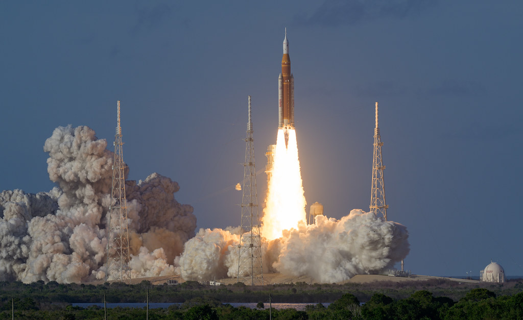
Liftoff! NASA Launches Astronauts on Historic Artemis Moon Mission
Spurred by American ingenuity, astronauts on NASA’s Artemis II mission are in flight, preparing for the first crewed lunar flyby in more than 50 years.
NASA’s SLS (Space Launch System) rocket lifted off from Launch Pad 39B at the agency’s Kennedy Space Center in Florida at 6:35 p.m. EDT Wednesday, sending four astronauts aboard the Orion spacecraft on a planned test flight around the Moon and back.
“Today’s launch marks a defining moment for our nation and for all who believe in exploration. Artemis II builds on the vision set by President Donald J. Trump, returning humanity to the Moon for the first time in more than 50 years and opening the next chapter of lunar exploration beyond Apollo. Aboard Orion are four remarkable explorers preparing for the first crewed flight of this rocket and spacecraft, a true test mission that will carry them farther and faster than any humans in a generation,” said NASA Administrator Jared Isaacman. “Artemis II is the start of something bigger than any one mission. It marks our return to the Moon, not just to visit, but to eventually stay on our Moon Base, and lays the foundation for the next giant leaps ahead.”
The successful launch is the beginning of an approximately 10-day mission for NASA astronauts Reid Wiseman, Victor Glover, Christina Koch, and CSA (Canadian Space Agency) astronaut Jeremy Hansen. As the first crewed mission of NASA’s Artemis program, among its objectives, the flight will demonstrate life support systems for the first time with crew and lay the foundation for an enduring presence on the Moon ahead of future missions to Mars.
After reaching space, Orion deployed its solar array wings, enabling the spacecraft to receive energy from the Sun, while the crew and engineers on the ground immediately began transitioning the spacecraft from launch to flight operations to start checking out key systems.
“Artemis II is a test flight, and the test has just begun. The team that built this vehicle, repaired it, and prepared it for flight has given our crew the machine they need to go prove what it can do,” said NASA Associate Administrator Amit Kshatriya. “Over the next 10 days, Reid, Victor, Christina, and Jeremy will put Orion through its paces so the crews who follow them can go to the Moon’s surface with confidence. We are one mission into a long campaign, and the work ahead of us is greater than the work behind us.”
About 49 minutes into the test flight, the SLS rocket’s upper stage fired to put Orion into an elliptical orbit around Earth. A second planned burn by the stage will propel Orion, which the crew named “Integrity,” into a high Earth orbit extending about 46,000 miles beyond Earth. After the burn, Orion will separate from the stage, flying free on its own.
In several hours, a ring on the rocket’s upper stage, which will be a safe distance away from the spacecraft, will deploy four CubeSats – small satellites from Argentina’s Comisión Nacional de Actividades Espaciales, German Aerospace Center, Korea AeroSpace Administration, and Saudi Space Agency – to perform scientific investigations and technology demonstrations.
The spacecraft will remain in high Earth orbit for about a day, where the crew will conduct a manual pilot demonstration to test Orion’s handling capabilities. The astronauts, with Mission Control Center teams at NASA’s Johnson Space Center in Houston, will continue checking spacecraft systems.
If all systems remain healthy, mission controllers will give Orion’s European-built service module a command to conduct the translunar injection burn on Thursday, April 2. This move is an approximately six-minute firing to send the spacecraft on a trajectory that will simultaneously carry crew around the Moon, while also harnessing lunar gravity to slingshot them back to Earth.
During a planned multi-hour lunar flyby on Monday, April 6, the astronauts will take photographs and provide observations of the Moon’s surface as the first people to lay eyes on some areas of the far side. Although the lunar far side will only be partially illuminated during the flyby, the conditions should create shadows that stretch across the surface, enhancing relief and revealing depth, ridges, slopes and crater rims that are often difficult to detect under full illumination. Crew observations and other human health scientific investigations during the mission, such as AVATAR, will inform science during future Moon missions.
Following a successful lunar flyby, the astronauts will return to Earth and splash down in the Pacific Ocean.
As part of Golden Age of innovation and exploration, NASA will send Artemis astronauts on increasingly difficult missions to explore more of the Moon for scientific discovery, economic benefits, and to build on our foundation for the first crewed missions to Mars.
Follow the latest mission progress, including more images from the test flight, visit:
https://www.nasa.gov/mission/artemis-ii/
-end-
Bethany Stevens / Rachel Kraft
Headquarters, Washington
202-358-1100
bethany.c.stevens@nasa.gov / rachel.h.kraft@nasa.gov
March of the Harmattan
- Earth
- Earth Observatory
- Image of the Day
- EO Explorer
- Topics
- More Content
- About
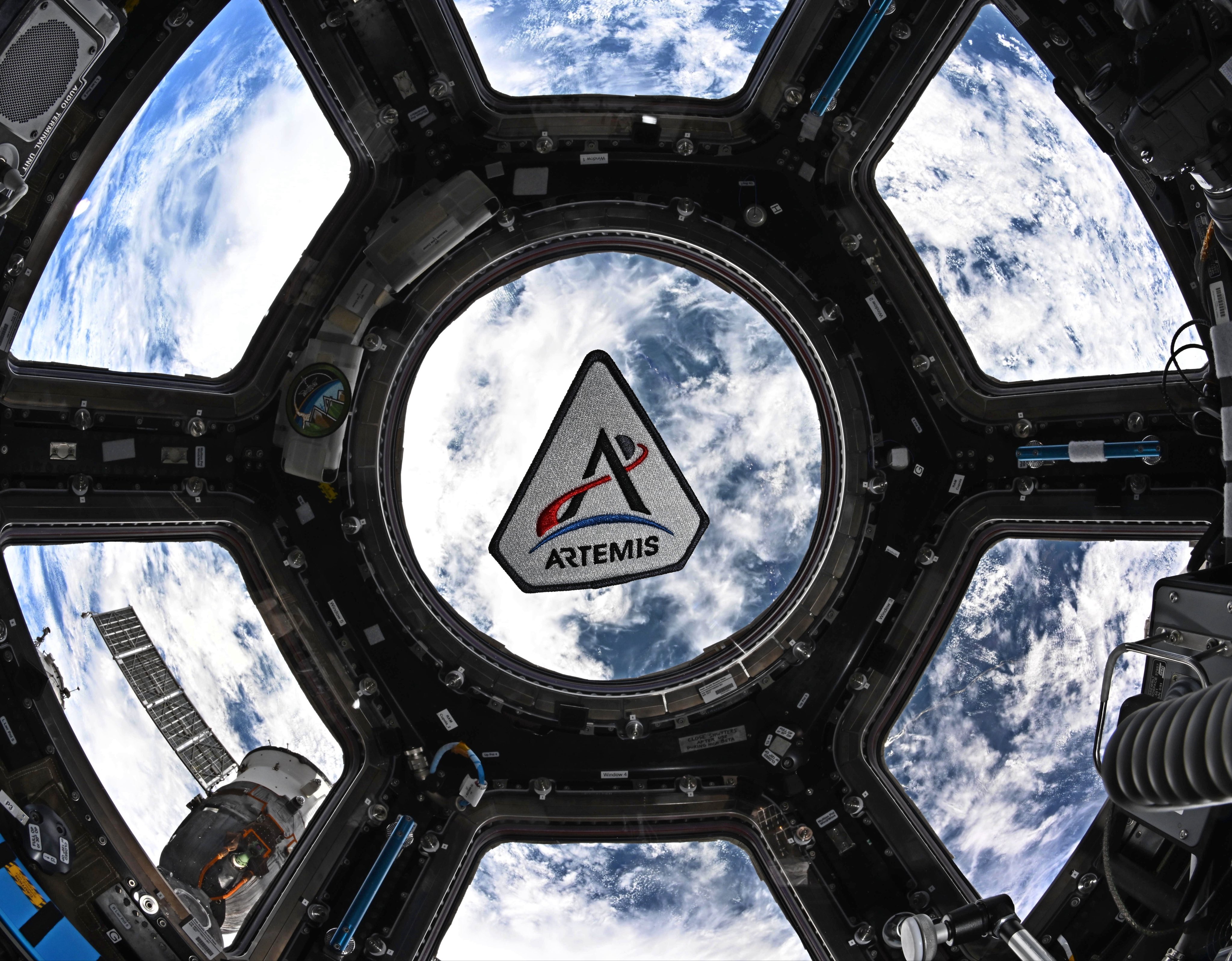
Godspeed, Artemis II!
NASA astronaut Jessica Meir took this photo of an Artemis program patch floating in the International Space Station’s cupola. She posted it on X on March 30, 2026, with the following caption: “Our work on the @Space_Station has provided the foundation to explore further, preparing us to return humans to the Moon this week. Stay tuned as we enter the @NASAArtemis era! Expedition 74 will certainly be keeping a close watch. Godspeed, Artemis II!”
Image credit: NASA/Jessica Meir
Landsat Reveals Reservoir Changes and Bathymetry
- Landsat Home
- Missions
- News
- Data
- Benefits
- Outreach
- Multimedia
- About
- Search
Communities worldwide rely on reservoirs for drinking water, hydroelectric power, irrigation, and more. These critical freshwater resources are affected by seasonal and long-term changes; water levels in reservoirs can dip during hot summer months or due to prolonged drought, or can flood after a particularly strong storm. Despite their importance, there are key gaps in our knowledge of reservoir structure and dynamics. Two recent papers use Landsat data to help fill in those gaps.
Researchers from the University of Southampton used Landsat data to identify where water advanced or retreated from 1984 to 2022, creating the first global dataset pinpointing the exact year of permanent surface water changes—such as when a reservoir formed or a stream dried up. The study can track changes in streams as narrow as 30m and lakes as small as 900m2. In a separate study, Texas A&M University researchers used Landsat data to build a global bathymetry dataset called ‘3D-LAKES’ that enables water managers to estimate reservoir storage capacity.
To view this video please enable JavaScript, and consider upgrading to a web browser that
supports HTML5 video
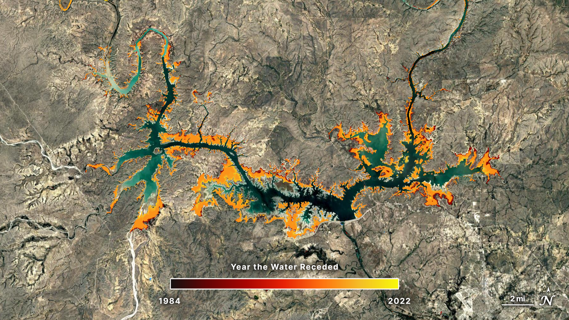
The above animation shows the Amistad Reservoir on the border of Texas and Mexico. It uses a natural-color Landsat image from 1985 overlaid onto a Copernicus Digital Elevation Model (DEM) and bathymetric data from the 3D-LAKES dataset. Vertical relief is exaggerated by a factor of four to emphasize topographic features and landforms. The reservoir is jointly managed by the U.S. and Mexico through the International Boundary and Water Commission (IBWC) for flood control, recreation, and hydroelectric power. Despite its importance to the two countries, the reservoir is slowly shrinking. The surface water transitions dataset shows the water levels retreating in recent decades, with significant recessions between 2012 and 2016. The 3D-LAKES dataset reveals the underwater shape of the reservoir. Together, these datasets complement the in situ water level and conditions data collected throughout the year.
Tracking Surface Water TransitionsHuman communities both shape and are shaped by water. We divert rivers, build reservoirs, and construct artificial islands, while natural forces—storms, meandering rivers, and rising seas—reshape our waterways and coastlines. With satellite data as an important tool to study ecosystem dynamics, researchers have begun to build a more comprehensive global understanding of where water is and how it shifts over time. In their water transitions study, the University of Southampton team focused specifically on permanent changes in lakes, rivers, coastlines, and other water bodies worldwide.
Looking at long-term changes in surface water can help scientists understand drivers of change, said Gustavo Willy Nagel, lead researcher on the paper. Knowing when a lake began receding helps water managers investigate whether drought, irrigation, or other forces caused the decline.
Running from July 31, 1985 to November 10, 2025, this animation shows that the Amistad Reservoir levels fluctuate with the seasons but slowly decline. The time series is composed of images from Landsats 5, 7, 8, and 9. Ross Walter/NASAScientists, policymakers, and water managers can explore the interactive dataset that Nagel and his team created to visualize changes close to home as well as stark global impacts such as the drying of the Aral Sea, the lakes created by melting glaciers in Tibet, and the building of the Palm Islands in Dubai.
Assessing long-term changes in surface water presents a key challenge, as surface water is extremely dynamic. Seasonal fluctuations and climatic forces mean that rivers, lakes, and coastlines are changing all the time. To identify permanent water changes while excluding seasonal fluctuations, the researchers ran two algorithms. The first detected whether the water body was advancing or retreating over the study period using the Modified Normalized Difference Water Index (mNDWI), which uses the shortwave-infrared (SWIR) instead of the near-infrared (NIR) band. The second algorithm used the Green_Red Normalized Difference Water Index (grNDWI)—an index proposed by the research team—to identify the precise year that the water body transitioned. A change was considered “permanent” if it did not revert to its previous condition during the study period of 1984 to 2022.
“The dataset is showing, for every location on the planet, areas where water advanced or retracted and the year of that change,” said Nagel.
This screenshot from the Water Change Time Detection tool on Google Earth Engine shows the Amistad Reservoir receding over time. Red and orange represent areas where water receded, whereas blue represents areas where water advanced. Major recessions occurred between 2012 and 2016. Ross Walter/NASA Visualizing Lakes in 3DLandsat can help us monitor surface water. But what about what’s under the surface?
In a study published in Scientific Data in October 2025, researchers from Texas A&M University fused Landsat and ICESat-2 data to create bathymetry maps for half a million global lakes and reservoirs. The research team, led by Huilin Gao, used Landsat imagery to calculate the surface area of water bodies, delineate where water meets land, and track how water extent changes over time. Then, they combined laser altimetry from the ICESat-2 satellite to infer the underwater bathymetry of water bodies. With these measurements, the scientists refined area-elevation relationships, a key metric for understanding how water storage changes with water level.
This screenshot from the 3D-LAKES dataset shows bathymetry in the Amistad Reservoir. Green represents shallow waters while purple represents deeper waters. Comparing this screenshot to the results from the water change detection tool, it appears that the areas where water receded align with the shallower portions of the reservoir. Ross Walter/NASAThe resultant dataset, dubbed 3D-LAKES, is static, as bathymetry does not tend to change significantly year to year. “This dataset can support many applications, from monitoring water storage to refining hydrological models,” said Chi-Hsiang Huang, the study’s lead author.
3D-LAKES can be used in combination with Landsat-based maps—like the surface transition research or the popular Global Surface Water dataset—to help water resource managers assess the volume of water held in a reservoir or lake. This allows them to evaluate flood risk, map habitat, or calculate how much water is available during a particularly dry season. Researchers can also track changing water volume over time, helping understand long-term trends in water storage.
Measuring underwater topography has historically been expensive and impractical at global scales. The 3D-LAKES dataset now provides researchers and managers with crucial bathymetric data for lakes and reservoirs worldwide. “With this new dataset, we can achieve a more comprehensive understanding of the impacts of lakes and reservoirs on regional climatology, water security, and ecosystem services,” said Gao. Both studies provide water and land managers with unprecedented tools for resource management and planning—from the Amistad Reservoir to the Australian Outback to the Brazilian Amazon.
Explore More
Landsat Reveals Reservoir Changes and Bathymetry
5 min read
In two recent studies, researchers used Landsat data to fill key gaps in our knowledge of reservoir structure and dynamics.
Mar 31, 2026 ArticleSeeing Blue During Schirmacher’s Summer Melt Season
5 min read
A network of meltwater lakes and drainage channels made an Antarctic ice shelf known for its blue ice areas even…
Mar 30, 2026 ArticleSatellite Spots a Spawn
3 min read
The activity of herring around Vancouver Island in British Columbia brightened coastal waters enough to be detectable from space.
Mar 27, 2026 Article1
2
3
…
301
Next
Fires Tear Through Nebraska Grasslands
- Earth
- Earth Observatory
- Image of the Day
- EO Explorer
- Topics
- More Content
- About
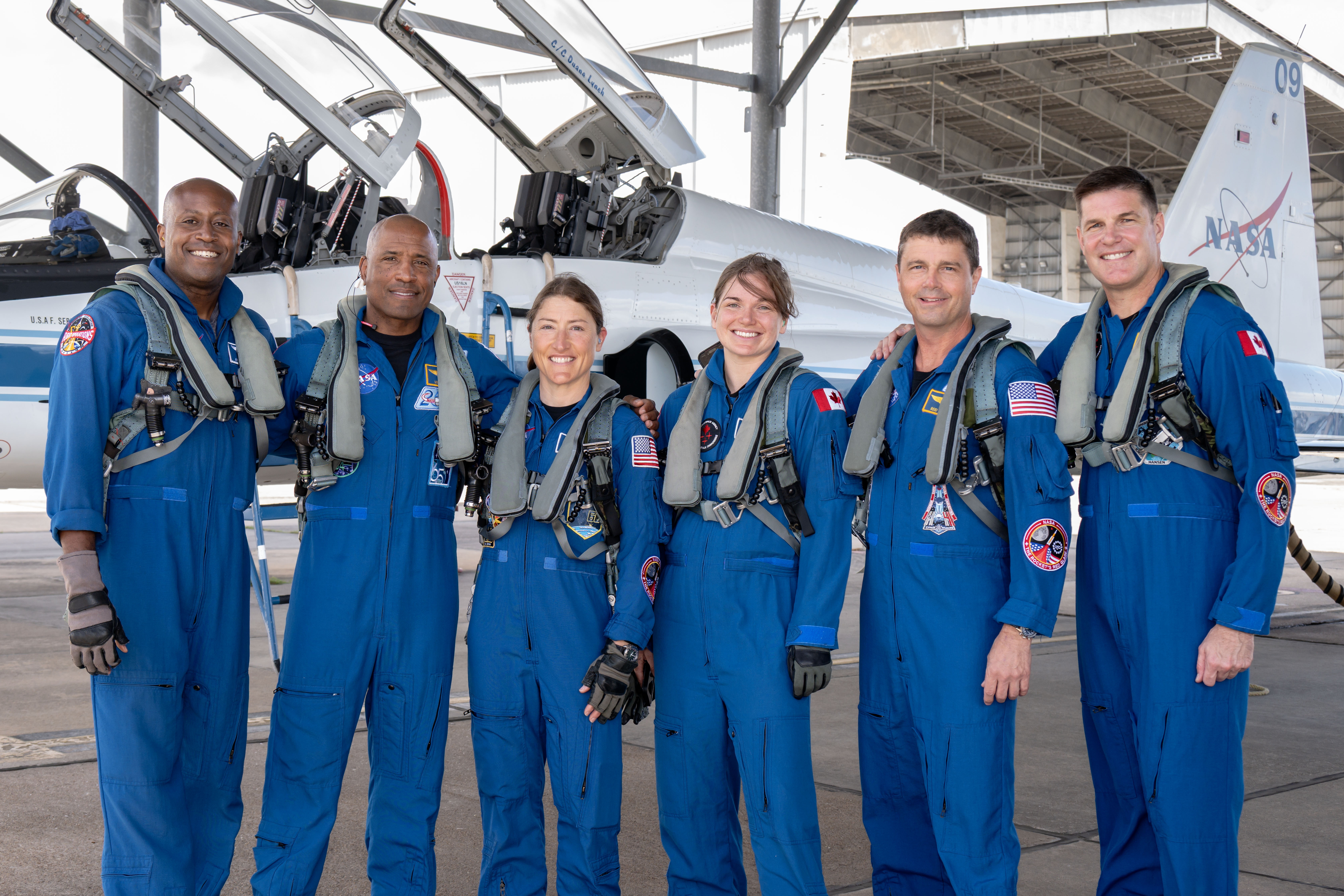
Sendoff for Artemis II Crew
From left to right, NASA astronauts Andre Douglas, Victor Glover, and Christina Koch, CSA (Canadian Space Agency) astronauts Jenni Gibbons, NASA astronaut Reid Wiseman, and CSA astronaut Jeremy Hansen pose for a photo before the Artemis II crew proceed to a media event on March 27, 2026. Douglas and Gibbons are the backup crew members for the mission; they would join the crew if a NASA or CSA astronaut, respectively, is unable to take part in the flight.
Artemis II is NASA’s first crewed mission under the Artemis program and will launch from the agency’s Kennedy Space Center in Florida. It will send Wiseman, Glover, Koch, and Hansen on an approximately 10-day journey around the Moon. Among other objectives, the agency will test the Orion spacecraft’s life support systems for the first time with people and lay the groundwork for future crewed Artemis missions.
Image credit: NASA/Josh Valcarcel
Seeing Blue During Schirmacher’s Summer Melt Season
- Earth
- Earth Observatory
- Image of the Day
- EO Explorer
- Topics
- More Content
- About
I Am Artemis: Erik Richards
0:00 / 0:00
Your browser does not support the audio element.For Erik Richards, supporting NASA’s first crewed Artemis mission to the Moon and back is the culmination of a career spent helping spacecraft communicate with Earth.
Like many kids who grew up at the height of the Space Shuttle Program, Richards dreamed of spaceflight — a dream that eventually took him from the remote McMurdo Station in Antarctica to NASA’s Goddard Space Flight Center in Greenbelt, Maryland.
I’ve spent my entire career moving across NASA’s network. At its core, it's an organization of people and interactions. I always say it’s not what you know, but who you know that makes the network go. There are so many opportunities to learn.Erik Richards
NASA Near Space Network Mission Manager
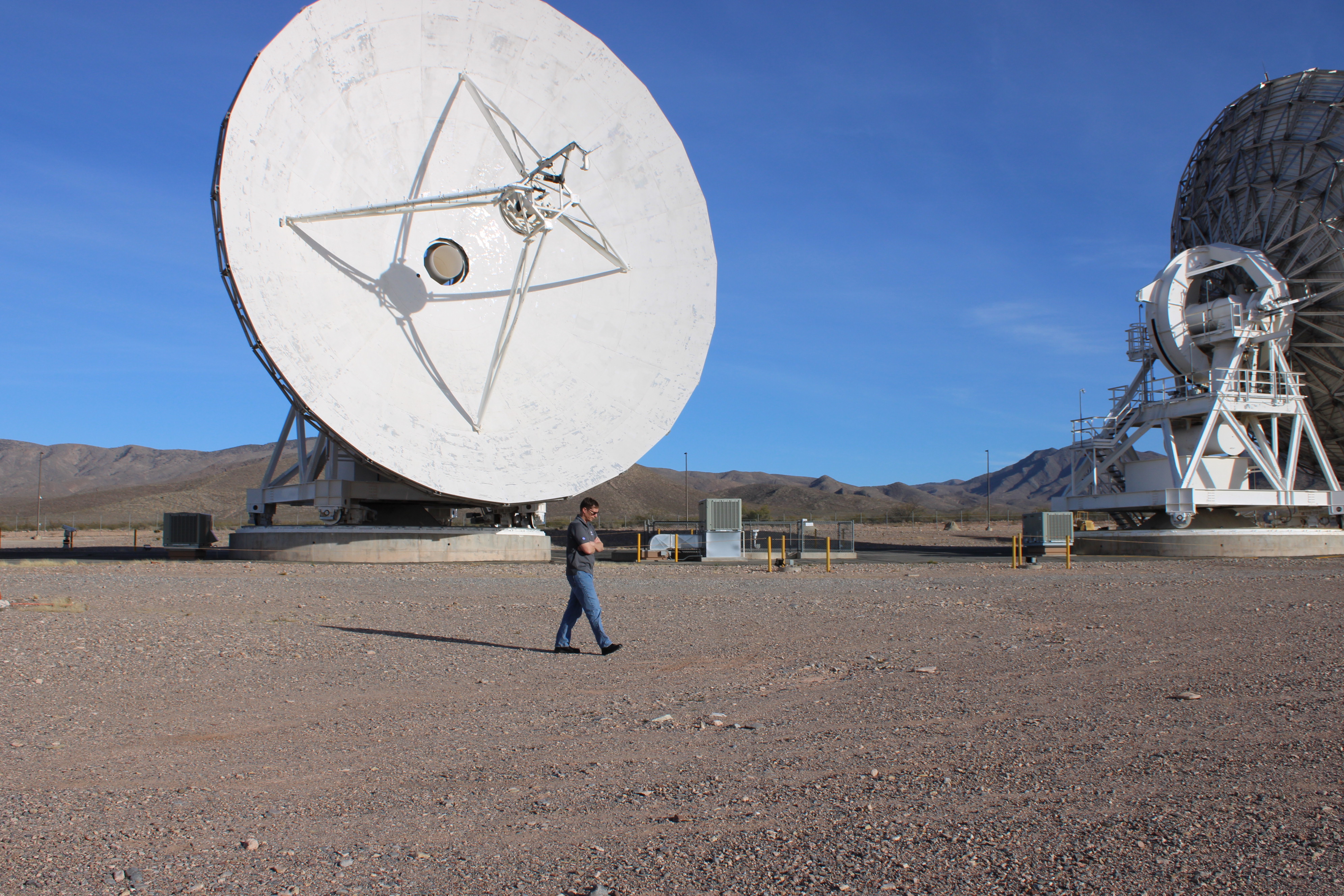
Most recently, his work has taken him to the agency’s White Sands Complex in New Mexico — and into a key role in America’s return to the Moon. As mission manager for NASA’s Near Space Network, Richards ensures the Artemis II crew and Orion spacecraft can communicate with Earth during liftoff and early orbit, through re-entry and splashdown.
Erik Richards at the White Sands Complex. The largest White Sands antennas are 18 meters (59 feet) in diameter.The Near Space Network consists of an interconnected web of relay satellites and more than 40 government and commercial ground stations stretching from Bermuda to South Africa. Together with NASA’s Deep Space Network, this global infrastructure is critical to keeping the Orion spacecraft and its four astronauts connected to mission control throughout their roughly 10-day mission.
It’s Richards’ job to keep the many pieces of the Near Space Network operating in sync across multiple missions. He compares the system to a telephone network on Earth: invisible when everything works, critical when it doesn’t. Without communications, there’s no contact with home.
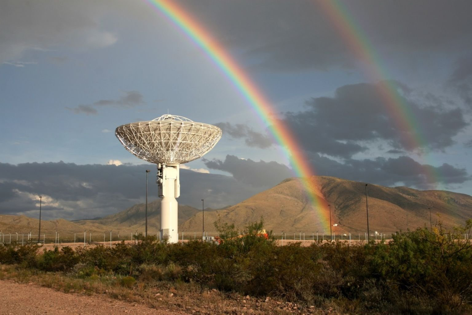
A Near Space Network antenna at the White Sands Ground Terminal. The Near Space Network is supporting the Artemis II mission during liftoff, early orbit, re-entry, and splashdown.NASAWorking with the Deep Space Network, Artemis II will rely on the Near Space Network for navigation, real-time voice communications, data transfer, and situational awareness. For Richards and the teams supporting NASA’s networks, having crew aboard makes their work more essential than ever.
Richards’ professional journey across the Near Space Network has been key to coordinating communications across the Artemis’ three flight segments, dozens of ground stations, and hundreds of people supporting humanity’s return to the Moon.
Artemis isn’t just one spacecraft. It’s multiple elements working together across every mission phase, each with its own communications demands. My role is making sure communications succeed for the rocket, the Orion spacecraft, and ultimately the crew.Erik Richards
NASA Near Space Network Mission Manager
In the months leading up to launch, Richards has supported extensive testing, requirements development, and readiness operations to prepare the network. During the mission, he will be on console, monitoring data flow and coordinating support across NASA and its partner sites worldwide.
The support Richards and his team provide Artemis II will carry forward to Artemis III and NASA’s goal of a sustained human presence on the lunar surface. For Richards, being part of that progression — from shuttle to the Moon and eventually Mars — connects him to his childhood love of spaceflight.
“The most exciting part about the Artemis campaign is being part of something greater,” said Richards. “You don’t have to be an astronaut to contribute to the future of human exploration.”
About the AuthorKorine PowersLead Writer and Communications StrategistKorine Powers, Ph.D. is a writer for NASA's SCaN (Space Communications and Navigation) Program office and covers emerging technologies, commercialization efforts, exploration activities, and more.
Share Details Last Updated Mar 27, 2026 EditorJimi RussellContactKorine Powerskorine.powers@nasa.govLocationGoddard Space Flight Center Related Terms Explore More 4 min read NASA Selects Participants to Track Artemis II Mission Article 2 months ago 5 min read Networks Keeping NASA’s Artemis II Mission Connected Article 2 months ago 4 min read NASA’s Orion Artemis II Optical Communications System (O2O) Article 3 years ago Keep Exploring Discover More Topics From NASAArtemis
Near Space Network
Communicating with Missions
Laser Communications
NASA Selects Intuitive Machines to Deliver Artemis Science, Tech to Moon
6 min read
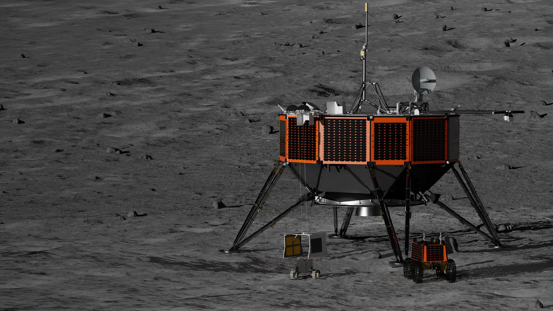
Preparations for Next Moonwalk Simulations Underway (and Underwater) A rendering of the Intuitive Machines larger cargo class lunar lander is pictured above with the Honeybee Robotics lunar rover (lower right) and the Australian Space Agency’s Roo-Ver lunar rover (lower left).Intuitive MachinesNASA has awarded Intuitive Machines of Houston, $180.4 million to deliver NASA-funded science and technology to the lunar surface as part of the agency’s CLPS (Commercial Lunar Payload Services) initiative and Artemis program. This lunar delivery, which includes seven payloads — five of them NASA’s — is expected to increase understanding of the chemical composition and structure of regolith, as well as the radiation environment in and around the South Pole region. This science will continue to build a sustainable human presence by future Artemis missions.
“NASA continues to progress lunar science and exploration by enabling commercial lunar landings,” said Joel Kearns, deputy associate administrator for exploration, Science Mission Directorate, at NASA Headquarters in Washington. “These science and technology investigations aim to support long-term sustainability and contribute to a deeper understanding of the lunar surface, test technologies, and prepare for future human missions at the South Pole.”
Intuitive Machines is responsible for delivering end-to-end payload services to the lunar surface, targeted to land at the Moon’s South Pole region in 2030. This is the fifth CLPS contract for the company, which has delivered payloads to the Moon twice with their IM-1 and IM-2 missions.
“As NASA prepares to send humans and more robotic missions to the Moon, regular CLPS deliveries will provide a better understanding of the exploration environment, accelerating progress toward establishing a long-term human presence on the Moon, setting the stage for eventual human missions to Mars,” said Adam Schlesinger, manager of the CLPS initiative at NASA’s Johnson Space Center in Houston.
The rovers and instruments, totaling 165 pounds (75 kilograms) in collective mass include:
- Stereo Cameras for Lunar Plume Surface Studies (SCALPSS) will use enhanced stereo imaging photogrammetry, active illumination, and ejecta impact detection sensors to capture the impact of the engine exhaust plume on lunar regolith as the lander descends on the Moon’s surface. This payload flew on both Intuitive Machines’ IM-1 and Firefly Aerospace’s Blue Ghost Mission 1 and captured first of its kind imagery. The high-resolution stereo images will aid in creating models to predict lunar regolith erosion and ejecta characteristics, which is important as bigger, heavier spacecraft and hardware are delivered to the Moon near each other.
Lead organization: NASA’s Langley Research Center in Hampton, Virginia - Near-Infrared Volatiles Spectrometer System (NIRVSS) will observe light emitted or reflected by the lunar soil to help identify its composition. NIRVSS is designed to detect minerals and various types of ices that may be present. NIRVSS will also take high resolution images of the lunar soil and composition variability, which could help inform how ices interact with the lunar soil. The instrument successfully powered on and collected data while in flight on Astrobotic’s Peregrine Mission One in 2024. NIRVSS aims to measure the surface temperature at fine scales, which may help determine where ice can exist or remain stable.
Lead organization: NASA’s Ames Research Center in California’s Silicon Valley - Mass Spectrometer for Observing Lunar Operations (MSolo) will characterize the makeup of volatiles (things that easily evaporate) in the environment around the lander following touchdown. The mass spectrometer demonstrated its gas analysis capabilities in lunar conditions during Intuitive Machines’ IM-2 mission in 2025. MSolo measures low molecular weight volatiles, which can be used as resources on the lunar surface.
Lead organization: NASA’s Kennedy Space Center in Florida - Lunar Vehicle Radiation Dosimeter system (LVRaD), a suite of four radiation detectors, is designed to quantify the radiation environment on the lunar surface and assess its potential impacts of radiation on biology and the human body in preparation for future human-related activities on the Moon. Additional sensors will investigate volatiles and geological resources that will help us plan for long-term exploration, as well as gain insights into the Moon’s formation and solar system evolution.
Lead organization: Korea Astronomy and Space Science Institute - Multifunctional Nanosensor Platform (MNP) is a highly compact and sensitive chemical analysis instrument designed to advance understanding of the lunar environment. It will investigate how exhaust plumes from a lander’s engines interact with the lunar regolith by measuring volatile compounds over time and at varying distances from the landing site. These measurements will provide critical data to better understand plume-surface interactions and their effects, informing the design of safer, more sustainable landing systems and surface operations, directly supporting NASA’s broader lunar exploration objectives. To enable these measurements, the MNP instrument will be integrated into the Australian Space Agency’s rover (“Roo-ver”), a foundation services technology demonstration. The rover will showcase Australia’s robotics capabilities, with the ability to traverse complex terrain and operate with limited human intervention. In doing so, Roo-ver will validate key mobility and autonomy technologies in the lunar environment while serving as the enabling platform for MNP’s scientific objectives.
Lead organization for MNP: NASA’ Goddard Space Flight Center in Greenbelt, Maryland
Lead organization for Roover: Australian Space Agency
- NASA’s Laser Retroreflector Array (LRA) is a small device that reflects laser beams transmitted by Moon orbiters or landing spacecraft to help them determine their orbit position or navigate to the surface. Made of eight quartz corner-cube prisms set into a dome-shaped aluminum frame, the array is passive, meaning it requires no power or maintenance. One LRA payload has already been delivered through CLPS to the surface of the Moon. These arrays will continue to be used to build a network of permanent location markers on the Moon for future exploration.
Lead development organization: NASA’s Goddard Space Flight Center - “Sanctuary on the Moon” is a lunar time capsule of 24 synthetic sapphire discs containing a curated archive of human civilization. The discs highlight over 100 billion micropixels of data including the history of science, technology, mathematics, architecture, culture, paleontology, art, literature, music, and the human genome. Sanctuary was developed in France.
Lead organization: Grapevine Productions
Through NASA’s CLPS initiative, lunar landing and surface operations services are purchased from American companies. By sending science and technology to the Moon, we continue to learn how to prepare for human exploration that could eventually take us to Mars.
For more information about CLPS and Artemis:
-end-
Tiffany Blake
Headquarters, Washington
202-358-2546
tiffany.n.blake@nasa.gov
Kenna Pell / Ivry Artis
Johnson Space Center, Houston
281-483-5111
kenna.m.pell@nasa.gov / ivry.w.artis@nasa.gov
NASA’s Environment and Energy “Blue Marble” Awards Categories
2 min read
Preparations for Next Moonwalk Simulations Underway (and Underwater) The famous Blue Marble image taken by Apollo 17 astronauts on their way to the Moon in 1972 Category I: NASA Environmental Quality AwardRecognizes excellence in environmental management and planning, including stewardship of natural and cultural resources. This category highlights achievements in compliance, conservation, remediation, communication, and environmental information management, and the development of strong stakeholder partnerships.
Category II: NASA Award for Excellence in Project or Program ExecutionHonors efforts that reduce cost, time, or level of effort while achieving and maintaining compliance for projects or programs that directly support NASA’s mission. This category emphasizes operational efficiency, innovation, performance, and sustained compliance.
Category III: NASA Excellence in Energy and Water Management AwardAcknowledges significant achievements in energy efficiency, water conservation, and renewable energy integration. This award highlights projects that demonstrate measurable improvements in resource management and sustainable practices across NASA facilities and operations.
Category IV: NASA Excellence in Site Remediation AwardRecognizes innovation in site remediation technologies, stakeholder engagement, exposure risk reduction, beneficial reuse, and expedited remediation efforts. This category celebrates projects that successfully address environmental challenges while maintaining safety and compliance.
Category V: NASA Environmental Management Division Director’s Environment and Energy AwardSelected by the director of the Environmental Management Divsion, this award honors exceptional leadership in advancing environmentally responsible mission success. It is reserved for individuals or teams demonstrating outstanding vision and commitment to environmental stewardship across NASA’s programs.
Share Details Last Updated Mar 27, 2026 Related Terms Explore More 2 min read NextSTEP-3 E: Network Extension for User Continuity and Sustainability (NEXUS) Ka-Band Backward-Compatible Relay Article 5 days ago 7 min read NASA Releases Artemis II Moon Mission Launch Countdown Article 6 days ago 3 min read NASA Ames Experts Available for Artemis II Flight Test Interviews Article 7 days ago Keep Exploring Discover Related TopicsMissions
Humans in Space
Climate Change
Solar System
NISAR’s View of Mount Rainier
NASA/JPL-Caltech Photojournal Navigation Downloads PIA26672-NISAR’s View of Mount Rainier
JPEG (2.05 MB)
Description
This image captured by U.S.-Indian Earth satellite NISAR on Nov. 10, 2025, shows Washington’s Mount Rainier. The image is cropped from a much larger swath spanning the Pacific Northwest on a cloudy day; NISAR’s L-band SAR instrument is able to peer through the clouds at the surface below.
In Pacific Northwest imagery from the NASA-ISRO Synthetic Aperture Radar mission, some areas are dotted in magenta due to radar signals strongly reflecting off flat surfaces like roads and buildings, combined with the orientation of those surfaces relative to the satellite’s ground track. The yellow can be produced by a range of different factors, including land cover, moisture, and surface geometry. Yellow-green in the imagery generally indicates vegetation, such as the forests and wetlands covering the region.
Relatively smooth surfaces, including water and — as is most likely the case in this image — vegetation-free clearings on the mountaintop, appear dark blue. Near the foot of the mountain are patches of purple squares cut into the lighter green vegetation. Their precise right angles show that they’re clearly man-made; they’re likely the effect of forests being thinned or possibly vegetation growing back after having been thinned in the past.
A joint mission developed by NASA and the Indian Space Research Organisation (ISRO), NISAR launched in July 2025 from Satish Dhawan Space Centre on India’s southeastern coast. Managed by Caltech, JPL leads the U.S. component of the project and provided the satellite’s L-band SAR and antenna reflector. ISRO provided NISAR’s spacecraft bus and its S-band SAR..)
The NISAR satellite is the first to carry two SAR instruments at different wavelengths and will monitor Earth’s land and ice surfaces twice every 12 days, collecting data using the spacecraft’s giant drum-shaped reflector, which measures 39 feet (12 meters) wide — the largest radar antenna reflector NASA has ever sent into space.
To learn more about NISAR, visit:
https://science.nasa.gov/mission/nisar/
Keep Exploring Discover More Topics From Photojournal
Photojournal
Search Photojournal
Photojournal’s Latest Content
Feedback
Downloads PIA26672-NISAR’s View of Mount Rainier
JPEG (2.05 MB)
NISAR Views Mount St. Helens
NASA/JPL-Caltech Photojournal Navigation Downloads NISAR Views Mount St. Helens
JPEG (13.62 MB)
Description
This image captured by U.S.-Indian Earth satellite NISAR on Nov. 10, 2025, shows Washington’s Mount St. Helens. The image is cropped from a much larger swath spanning the Pacific Northwest on a cloudy day; NISAR’s L-band SAR instrument is able to peer through the clouds at the surface below.
In Pacific Northwest imagery from the NASA-ISRO Synthetic Aperture Radar mission, some areas are dotted in magenta due to radar signals strongly reflecting off flat surfaces like roads and buildings, combined with the orientation of those surfaces relative to the satellite’s ground track. The yellow can be produced by a range of different factors, including land cover, moisture, and surface geometry. Yellow-green in the imagery generally indicates vegetation, such as the forests and wetlands covering the region.
Relatively smooth surfaces, including water and — as is most likely the case in this image — vegetation-free clearings on the mountaintop, appear dark blue. Near the foot of the mountain are patches of purple squares cut into the lighter green vegetation. Their precise right angles show that they’re clearly man-made; they’re likely the effect of forests being thinned or possibly vegetation growing back after having been thinned in the past.
A joint mission developed by NASA and the Indian Space Research Organisation (ISRO), NISAR launched in July 2025 from Satish Dhawan Space Centre on India’s southeastern coast. Managed by Caltech, JPL leads the U.S. component of the project and provided the satellite’s L-band SAR and antenna reflector. ISRO provided NISAR’s spacecraft bus and its S-band SAR.
The NISAR satellite is the first to carry two SAR instruments at different wavelengths and will monitor Earth’s land and ice surfaces twice every 12 days, collecting data using the spacecraft’s giant drum-shaped reflector, which measures 39 feet (12 meters) wide — the largest radar antenna reflector NASA has ever sent into space. To learn more about NISAR, visit:
To learn more about NISAR, visit:
https://science.nasa.gov/mission/nisar/
Keep Exploring Discover More Topics From Photojournal
Photojournal
Search Photojournal
Photojournal’s Latest Content
Feedback
Downloads NISAR Views Mount St. Helens
JPEG (13.62 MB)
NASA Tech and Science Bound for Low Earth Orbit on Commercial Launch
6 min read
Preparations for Next Moonwalk Simulations Underway (and Underwater) Official insignia of the National Aeronautics and Space Administration. NASATechnology and science demonstrations, supported by various NASA industry collaborations and agency developments, are set to launch to low Earth orbit aboard a SpaceX Falcon 9 rocket as part of the company’s Transporter-16 commercial rideshare mission. These demonstrations will test thermal protection systems, advance in-space communications, deepen our understanding of Earth’s atmosphere, and foster capabilities for NASA’s exploration, innovation, and research goals.
The 57-minute launch window opens at 6:20 a.m. EDT (3:20 a.m. PDT) on Monday, March 30, from Space Launch Complex 4 East at Vandenberg Space Force Base in California. SpaceX will provide live coverage of the launch on its website and at @SpaceX on X, beginning about 15 minutes prior to liftoff.
Making big impacts with small satellitesSeveral demonstrations aboard this mission leverage small spacecraft technology to maximize flexibility, delivering greater value to the agency and its partners at a lower cost.
The AEPEX (Atmosphere Effects of Precipitation through Energetic X-rays) CubeSat will study how high-energy particles from Earth’s radiation belts transfer energy into the upper atmosphere through a process known as energetic particle precipitation. Currently, limited monitoring capabilities make it difficult to observe this phenomenon across large regions of Earth. The AEPEX CubeSat, supported by NASA’s CubeSat Launch Initiative and integrated on the mission via Exotrail, aims to address this by imaging the X-rays produced during precipitation events, enabling scientists to study and map the process. A better understanding of this activity could improve space weather forecasting, which has direct implications for radio communications, satellites, and other critical technologies.
As part of the MagQuest challenge, CubeSats will demonstrate novel solutions for measuring Earth’s magnetic field to inform the World Magnetic Model, which supports national security, commercial aviation, and everyday mobile devices. Launched in 2019 through NASA’s Center of Excellence for Collaborative Innovation, the agency supported the National Geospatial-Intelligence Agency in releasing the MagQuest challenge, which culminated in the development of three CubeSats built by three teams that advanced to the final phase of the competition. With testing done at NASA’s Goddard Space Flight Center in Greenbelt, Maryland, and additional support from the National Oceanic and Atmospheric Administration (NOAA), this competition exemplifies successful cross-cutting agency collaboration.
Aboard the TechEdSat23 CubeSat, integrated via Maverick Space Systems, NASA will test three key technologies: a radiation sensor called Radiation Shielding Efficacy Testbed funded by NASA’s Small Spacecraft and Distributed Systems (SSDS) office, a miniaturized NOAA Data Collection System radio, and a device called an exo-brake for rapid deorbiting of spacecraft. These technologies will advance critical capabilities for radiation shielding, satellite communications, and space weather monitoring to better equip small spacecraft for operations in low Earth orbit and deep space while acting as a test bed for potential larger scale applications.
The R5-S10 (Realizing Rapid, Reduced-cost high-Risk Research project Spacecraft 10) CubeSat, also supported by the SSDS office, will demonstrate technologies designed to expand the capabilities of small spacecraft in low Earth orbit. Deploying from the Vigoride orbital service vehicle operated by Momentus Space, the R5-S10 CubeSat will test proximity operations and formation flying techniques that allow spacecraft to safely operate at close distances, capabilities that could support future in-space inspection and servicing missions. The R5-S10 CubeSat will also carry a co-aligned event camera and star tracker proving a novel, high dynamic range, and high-rate tolerant star tracker, advancing technology to help spacecraft determine their orientation in space.
Enabling Wi-Fi in spaceAfter deployment from the Vigoride orbital service vehicle, the R5-S10 CubeSat will transfer data from its various demonstrations via Wi-Fi to an in-space router developed by the Solstar Space Company. In partnership with Momentus, Solstar’s in-space Wi-Fi router enables the R5-S10 CubeSat data to be downlinked through the Vigoride orbital service vehicle and eventually transferred to NASA’s Johnson Space Center in Houston. Solstar advanced its Wi-Fi technology for in-space use through suborbital testing with NASA’s Flight Opportunities program which is managed at NASA’s Armstrong Flight Research Center in Edwards, California.
Powering in-space logisticsAlso hosted aboard the Vigoride orbital service vehicle is a power processing system from CisLunar Industries. The company’s Electric Power Intelligent Conversion technology is designed to transform power ranging from 1 to 100 kilowatts with greater than 95% efficiency in smaller, lighter designs than the current state-of-the-art. This holds the potential to advance technology for in-space servicing, assembly, and manufacturing while serving government and commercial markets for dynamic space operations, including electric, dual-mode, and other forms of electric propulsion. The demo also is the first hosted orbital flight test for NASA’s Flight Opportunities program.
Advancing thermal protection technologyNASA also will launch technology on this flight to gather data about hypersonic atmospheric entry using sensors on a capsule from Varda Space Industries. As the latest in a series of flight tests, Varda’s W-6 capsule heat shield is equipped with a pair of instrumented tiles, made at NASA’s Ames Research Center in California’s Silicon Valley, that will collect data about the heat and pressure experienced as the capsule returns to Earth. The sensors also will capture performance data about the heat shield, which is made of C-PICA (Conformal Phenolic Impregnated Carbon Ablator), a material originally developed at NASA Ames that provides stronger, more efficient, and less expensive thermal protection, maximizing the safety and affordability of capsules returning to Earth.
By flying alongside commercial innovations, NASA continues leveraging cost-effective rideshare opportunities to accelerate technology development, innovations, and scientific discovery.
NASA’s Space Technology Mission Directorate manages the agency’s Small Spacecraft and Distributed Systems office, Flight Opportunities program, and the Center of Excellence for Collaborative Innovation. NASA’s CubeSat Launch Initiative is managed by the agency’s Launch Services program based at NASA’s Kennedy Space Center in Florida.
Facebook logo @NASATechnology @NASA_Technology Keep Exploring Discover More Topics From NASASpace Technology Mission Directorate
Flight Opportunities
Get Involved
Centers and Facilities
Share Details Last Updated Mar 27, 2026 EditorLoura Hall Related TermsNASA Names Scientists to Support Lunar South Pole Science
NASA has selected 10 participating scientists to help shape a science plan for astronauts to complete on the lunar surface under the Artemis program – including deploying scientific instruments, making critical observations of the landing site, and collecting Moon rocks.
“Congratulations to the scientists selected to participate in this important Artemis lunar surface science team,” said Joel Kearns, deputy associate administrator for exploration, Science Mission Directorate, NASA Headquarters in Washington. “The selected scientists will bring a wealth of expertise to this team to ensure we are supporting crews on the Moon to achieve the missions’ science objectives. Exploring the lunar surface and executing the U.S.’s science objectives is a major step toward sustained operations at the Moon and preparation for human exploration of Mars.”
The selected scientists are:
- Kristen Bennett, Northern Arizona University in Flagstaff
- Aleksandra Gawronska, The Catholic University of America in Washington
- Timothy Glotch, State University of New York, Stony Brook
- Paul Hayne, University of Colorado, Boulder
- Erica Jawin, Smithsonian Institution in Washington
- Jeannette Luna, Tennessee Technological University in Cookeville
- Sabrina Martinez, NASA’s Johnson Space Center in Houston
- Jamie Molaro, Planetary Science Institute in Tucson, Arizona
- Hanna Sizemore, Planetary Science Institute
- Catherine Weitz, Planetary Science Institute
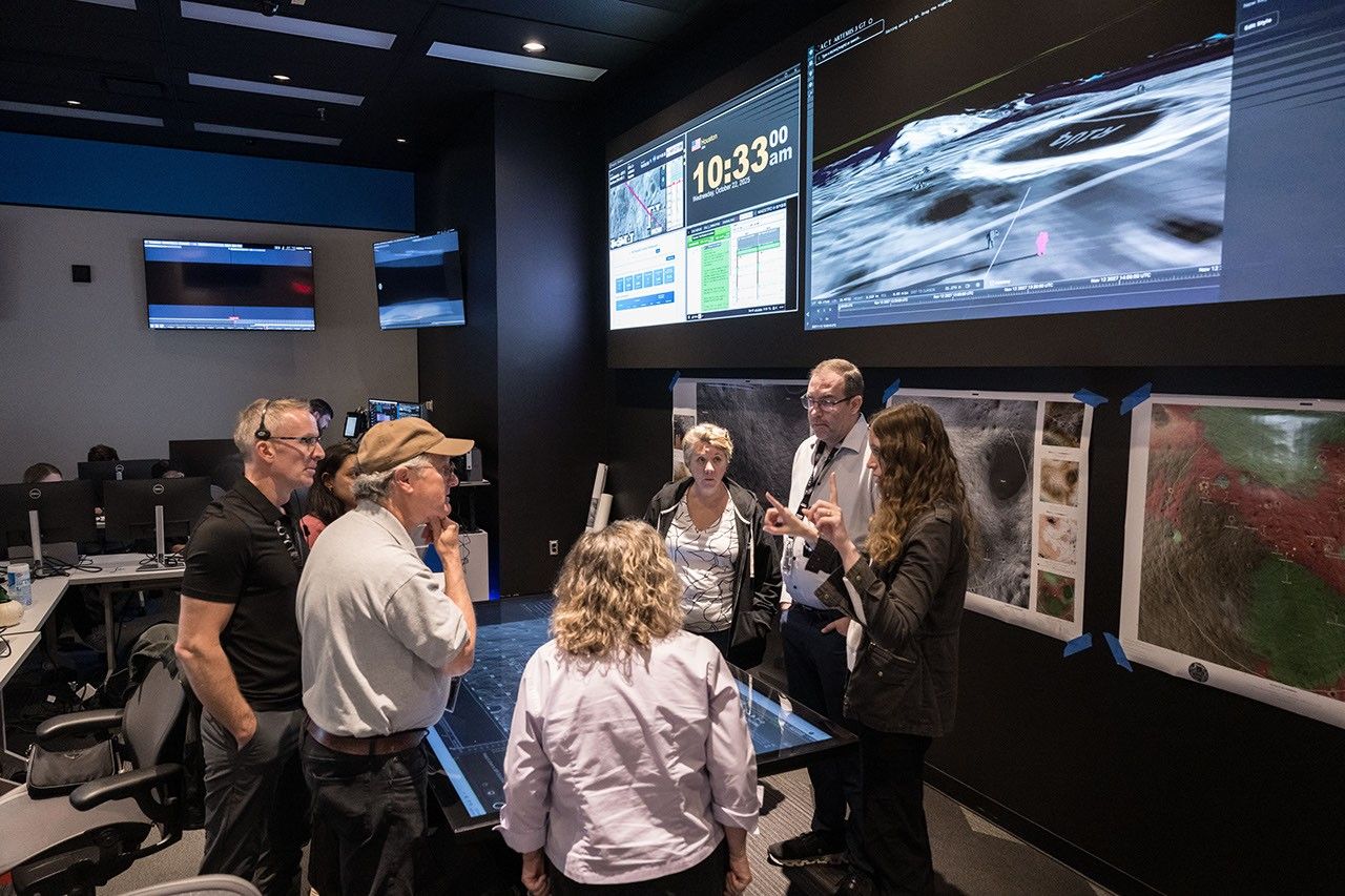
The participating scientists will join the first Artemis lunar surface science team, led by Noah Petro, project scientist, at NASA’s Goddard Space Flight Center in Greenbelt, Maryland, and Padi Boyd, deputy project scientist, at NASA Headquarters. In this role, they will support the inaugural Artemis geology team, led by Brett Denevi of the Johns Hopkins University Applied Physics Laboratory in Laurel, Maryland. The larger team also includes deployed instrument teams and the Artemis internal science team.
Members of NASA’s Artemis geology team discuss science objectives during a mission simulation at NASA’s Johnson Space Center on Oct. 22, 2025. Credits: NASA/Robert Markowitz“Artemis is enabling the kind of scientific work that will reshape our understanding of the Moon and open the door to discoveries we’ve only imagined,” said Lakiesha Hawkins, acting deputy associate administrator, Exploration Systems Development Mission Directorate at NASA Headquarters. “The work these scientists will contribute before, during, and after the mission will help us make the most of every step astronauts take on the lunar surface and ensure we’re learning as much as possible from this new era of human exploration.”
During the mission, astronauts will land near the Moon’s South Pole, a landscape of extremes with dark craters that contain may contain ice and mountain peaks in near-constant illumination. The scientific research during the first crewed Artemis lunar landing mission will provide critical data to support further exploration while digging deeper into questions that have intrigued scientists since the Apollo era – such as the impact history of the Moon or the locations of shallow ice deposits. In addition, the processes that the science team develops and tests during the first Artemis landed lunar mission will provide the framework for science operations during increasingly difficult missions to explore more of the Moon’s surface and subsurface.
The selected participants will engage in pre-mission planning, science mission operations, and work preparing the post-mission reports to address these questions.
Through Artemis, NASA will address high priority science questions in a Golden Age of exploration and discovery, focusing on those best accomplished by human explorers on and around the Moon and by using the unique attributes of the lunar environment. The Artemis missions will send astronauts to explore the Moon for scientific discovery, economic benefits, and build the foundation for the first crewed missions to Mars.
For more information on Artemis, visit:
Alise Fisher / Molly Wasser
Headquarters, Washington
202-358-1600
alise.m.fisher@nasa.gov / molly.l.wasser@nasa.gov
I Am Artemis: Michael Guzman
Listen to this audio excerpt from Michael Guzman, Artemis II main propulsion systems engineer:
0:00 / 0:00
Your browser does not support the audio element.A clue to what Mike Guzman, main propulsion systems engineer at NASA’s Kennedy Space Center in Florida, loves most can be found in the signature of his work email: a complex string of equations for rocket thrust, specific impulse, and the physics behind cooling liquid oxygen with helium bubbles.
I'm a huge nerd. I love math, science, and physics. Even in my free time, I'll find myself watching physics lectures.MiKE Guzman
Artemis II main propulsion systems engineer
Born in New York to a family from the Dominican Republic, Guzman moved to Florida where he earned a bachelor’s degree in mechanical engineering at Florida International University and a master’s degree in space systems from the Florida Institute of Technology. His path to NASA Kennedy began after being handpicked for a summer internship in 2013, an opportunity that would ultimately change the course of his career.
During his internship, Guzman was inspired to build his own rocket. He purchased a textbook and began building a model rocket in his free time. The drive and passion he put into the project did not go unnoticed. Just three days after the model rocket launched, he was offered a job and has worked for America’s space agency ever since.
Mike Guzman, main propulsion systems engineer, participates in a wet dress rehearsal for the Artemis II mission on Monday, Feb. 2, 2026, inside Firing Room 1 at the Rocco A. Petrone Launch Control Center at NASA’s Kennedy Space Center in Florida. The wet dress rehearsal allows the Artemis II launch team to run through operations to load propellant, conduct a full launch countdown, demonstrate the ability to recycle the countdown clock, and drain the tanks to practice timelines and procedures for launch. NASA/Kim ShiflettGuzman began his work with a model rocket, and now, as part of Exploration Ground Systems, is part of the team launching the rocket that will carry astronauts around the Moon for the first time in more than 50 years: the SLS (Space Launch System) rocket for Artemis II.
Guzman joined the propulsion team in 2019. Early in his role, he focused on hydrogen systems at Launch Pad 39B, including the large liquid hydrogen sphere at the pad and the piping that delivers propellant to the rocket. Today, he works on the main propulsion system inside the rocket itself, a role that will put him in the firing room for the Artemis II test flight, at the center of launch operations.
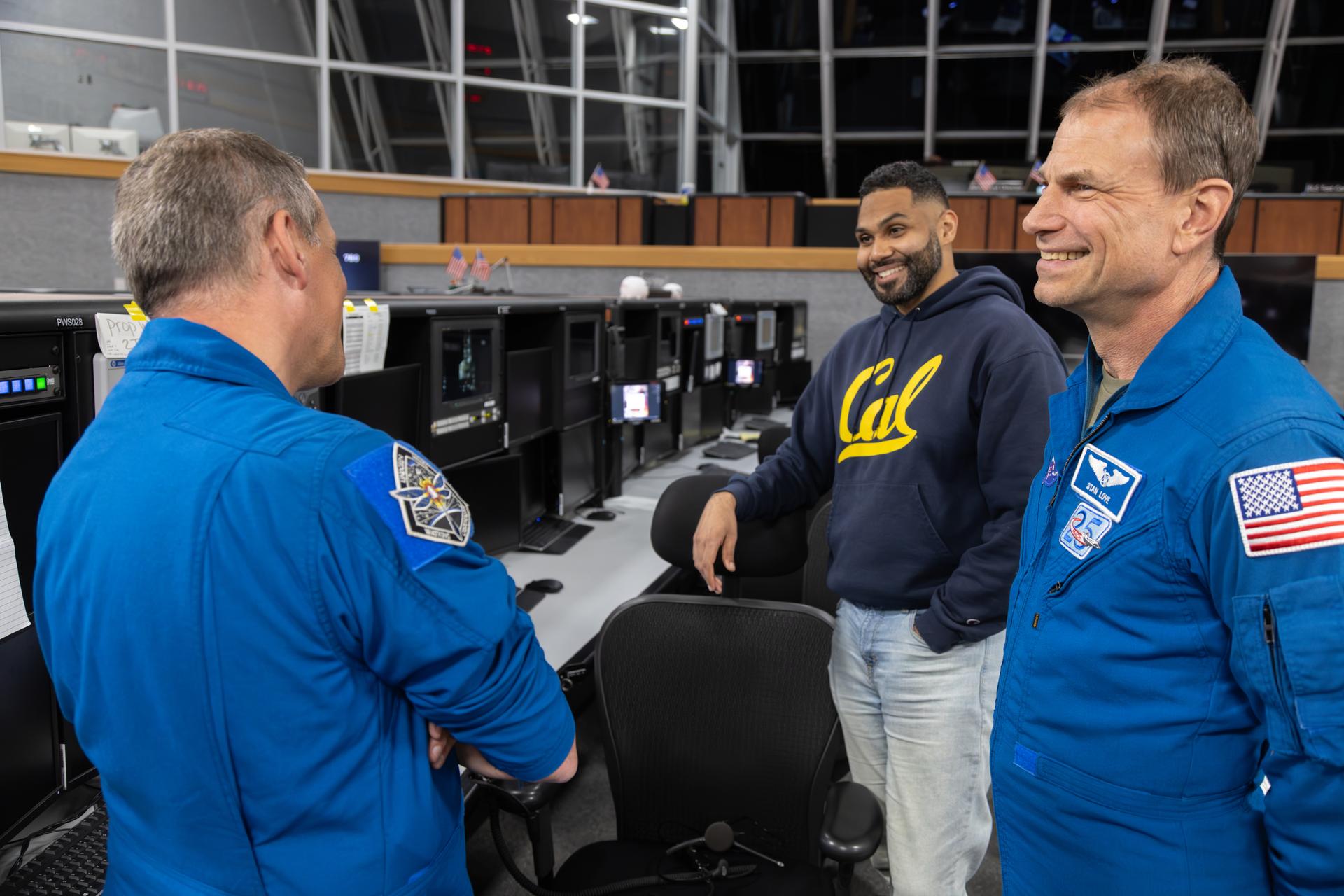
From left, NASA astronauts Bob Hines and Stan Love talk with Mike Guzman, Artemis launch team member, inside Firing Room 1 of the Rocco A. Petrone Launch Control Center during the Artemis II rollout of the SLS (Space Launch System) rocket and Orion spacecraft from the Vehicle Assembly Building to Launch Complex 39B at NASA’s Kennedy Space Center in Florida on Friday, March, 20, 2026. NASA/Amber Jean NotvestAt the heart of Guzman’s work is the “brain book,” a comprehensive binder that contains every drawing, requirement, procedure, and launch commit criteria an engineer might need. It’s a roadmap for efficiency. By studying it in advance, Guzman and his colleagues know exactly where to find what they need and how to respond to unexpected issues.
The key to a successful launch relies on teamwork. On launch day, hundreds of engineers come together in the firing room to monitor every system on the spacecraft. Each console operator’s actions influence the others’, creating a constant interplay where observation, communication, and anticipation are key to mission success.
It has to be a team sport. We’re all sitting in different parts of a whole, that ‘one whole’ being the spacecraft. We all have to work together. We all must have a sense of what the other individuals are doing and what their roles are, because at the end of the day, it’s all interconnected.MiKE Guzman
Artemis II main propulsion systems engineer
For Guzman, Artemis II represents the culmination of years of preparation, study, and collaboration.
“It’s not something that happens every day, and it’s not something that you get to be a part of every day,” Guzman said. “To see it finally happen, it’s going to be incredible.”
About the AuthorGabriella BattenfieldStrategic Communications Intern Share Details Last Updated Mar 27, 2026 Related Terms Explore More 3 min read I Am Artemis: Erik Richards Article 3 days ago 6 min read NASA Selects Intuitive Machines to Deliver Artemis Science, Tech to Moon Article 3 days ago 6 min read NASA Tech and Science Bound for Low Earth Orbit on Commercial Launch Article 3 days ago Keep Exploring Discover More Topics From NASAMissions
Humans in Space
Climate Change
Solar System
NextSTEP-3 E: Network Extension for User Continuity and Sustainability (NEXUS) Ka-Band Backward-Compatible Relay
Synopsis | 03/23/26
https://sam.gov/workspace/contract/opp/e33cd0cc61064a6497a55fca8e9b30c6/view
NASA intends to release a BAA under Next Space Technologies for Exploration Partnerships (NextSTEP-3), Appendix E, for Project NEXUS, Ka-band Backward- Compatible Relay. As the aging Tracking and Data Relay Satellite System (TDRS) declines, NASA’s objective is to acquire an end-to-end Ka-band relay service, including space, ground, launch, integration, and operations elements, that is backward compatible with legacy TDRS users for a minimum of fifteen years. This capability is needed to support select on-orbit missions that cannot feasibly modify flight hardware or transition to non-compatible commercial services. To reduce growing continuity risk in the 2029- 2031 timeframe, industry is asked to develop and demonstrate this end-to-end capability. The BAA will be a phased competitive Research and Development (R&D) acquisition. NASA anticipates multiple initial Firm-Fixed-Price (FFP) awards with progressive downselects based on demonstrated performance, technical credibility, and commercial viability. NASA does not anticipate being the sole commercial customer and anticipates proposed solutions to be supported by a broader commercial business case beyond NASA.
NASA seeks to accelerate maturation of commercially viable capabilities through competitive research demonstrations to support transition to future operational services, while preserving full and open competition for those services. All proposed satellite orbit solutions are acceptable notwithstanding that the proposed solutions will be expected to include all elements necessary for industry to develop, deliver and sustain the end-to-end relay service capability, including, but not limited to: Space segment, associated launch services, as applicable, ground and network infrastructure, and service operations and maintenance. Accordingly, NASA may use knowledge gained through this BAA, including demonstration results, technical data, and operational insight, to inform future acquisition strategies for operational services.
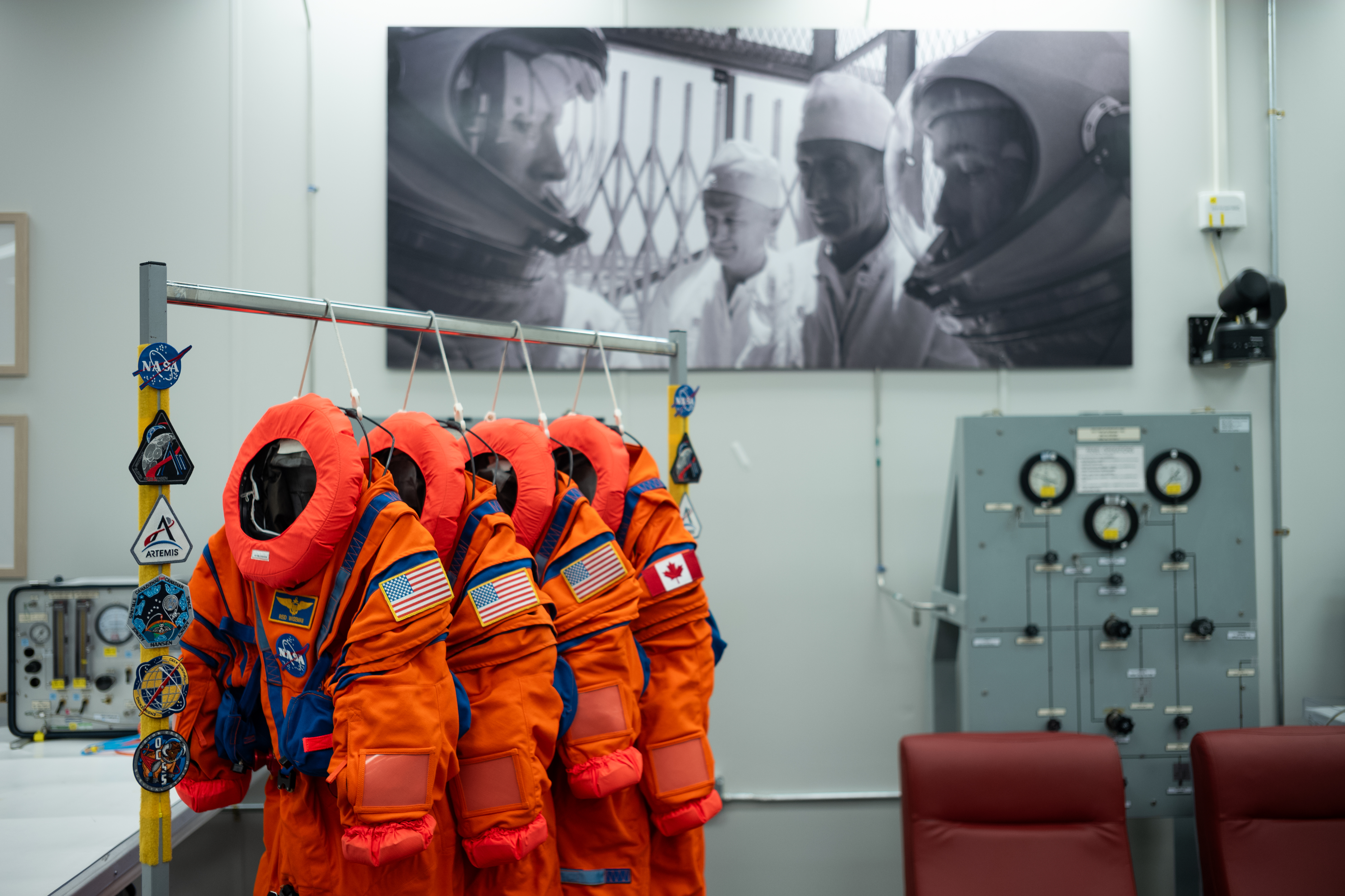
Artemis II Crew’s Suits
The Orion Crew Survival System suits that Commander Reid Wiseman, Pilot Victor Glover, and Mission Specialist Christina Koch from NASA, and Mission Specialist Jeremy Hansen from the CSA (Canadian Space Agency) will wear on the Artemis II test flight are seen in the suit-up room of the Neil A. Armstrong Operations and Checkout Building, Saturday, Jan. 17, 2026, at NASA’s Kennedy Space Center in Florida.
The Artemis II test flight will be NASA’s first mission with crew aboard the SLS (Space Launch System) rocket and Orion spacecraft. Through Artemis, NASA will send astronauts to explore the Moon for scientific discovery, economic benefits, and to build the foundation for the first crewed missions to Mars.
Image credit: NASA/Joel Kowsky
Satellite Spots a Spawn
- Earth
- Earth Observatory
- Image of the Day
- EO Explorer
- Topics
- More Content
- About
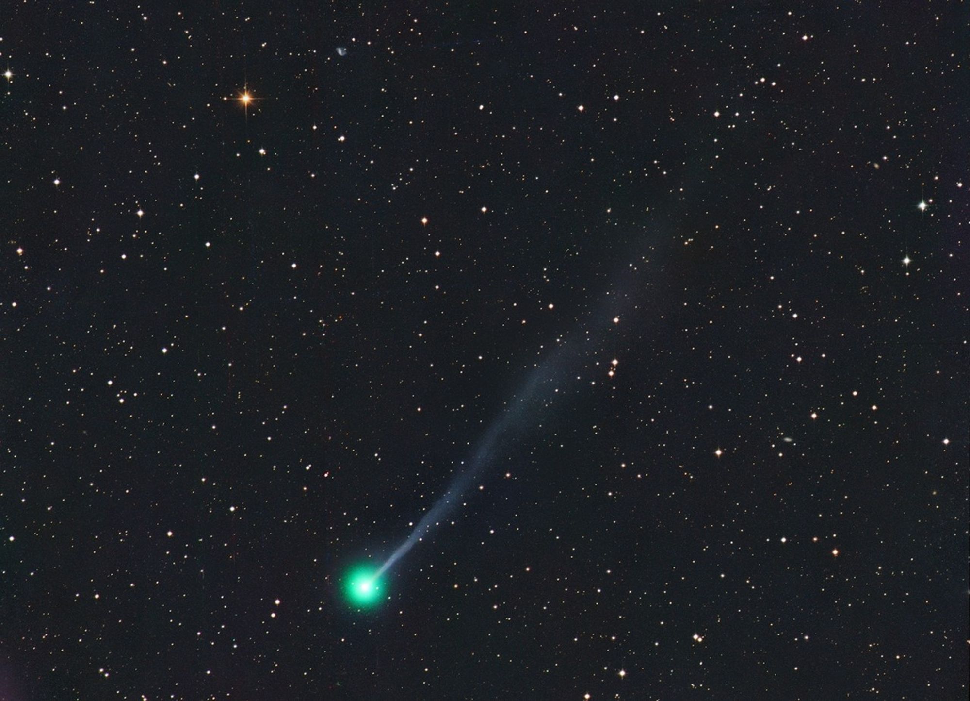
What’s Up: April 2026 Skywatching Tips from NASA
Mercury shines at its brightest for the year, the Lyrid meteor shower peaks, and a bright new comet makes an appearance in April’s night sky.
Skywatching Highlights- April 3: Mercury at greatest elongation
- April 17: Best chance to see Comet C/2025 R3
- April 21 to 22: Lyrid meteor shower peak
- April 27: Comet C/2025 R3 makes closest approach to Earth
Mercury shines extra bright, the Lyrid meteor shower peaks, and a comet soars into view. That’s What’s Up this April.
On April 3rd, Mercury will be at its most visible all year. On this date, the planet will be at its greatest elongation, or its furthest distance from the Sun, as we see it from Earth, making it easier to see the often hard-to spot-planet.
To find Mercury, look east before the Sun begins to rise. The planet will be very low on the horizon, just above Mars.
The Lyrid meteor shower peaks April 21st to 22nd. This meteor shower comes from debris left behind by Comet Thatcher.
When this debris hits and then burns up in our atmosphere, we see the “shooting stars” of a meteor shower.
To experience the peak of the April Lyrids, look to the east starting at around 10 p.m. on April 21st and through the night into April 22nd. The meteor shower takes place nearby the star Vega, the fifth brightest star in the night sky, which can be found in the constellation Lyra, the Harp.
April 17th might be your best chance to see the Comet C/2025 R3, which some think could be the brightest comet of the year. This comet will make its closest approach to Earth on April 27th, coming within 44 million miles of our planet.
Experts estimate that the comet will likely reach magnitude eight, which means you would need access to a telescope or binoculars to see it. The comet will be visible in the eastern sky in the constellations Pegasus and above Pisces. You’ll be able to spot the comet in the predawn hours from mid-April through the end of April in the Northern Hemisphere, and in the evenings in early May for viewers in the Southern Hemisphere.
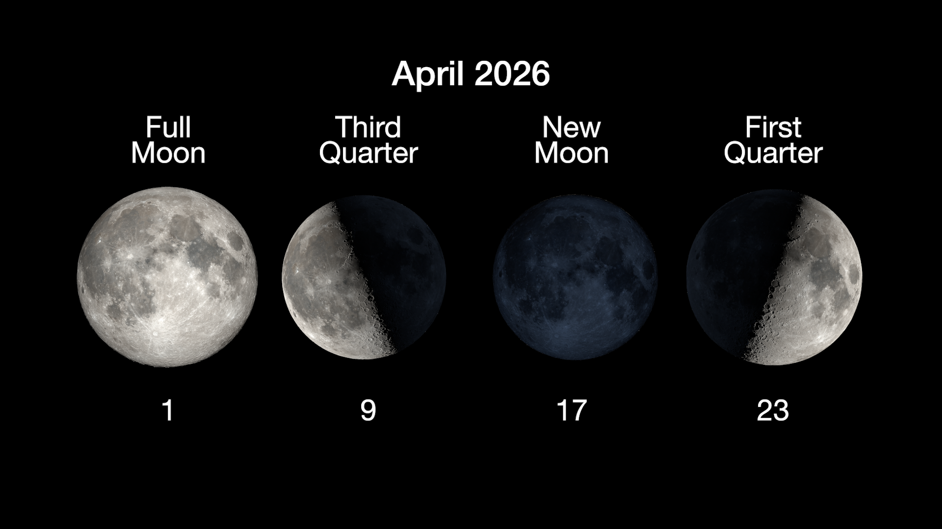
Here are the phases of the Moon for April. You can stay up to date on all of NASA’s missions exploring the solar system and beyond, at science.nasa.gov. I’m Chelsea Gohd from NASA’s Jet Propulsion Laboratory and that’s What’s Up for this month.
Keep Exploring Discover More Topics From NASA
What’s Up
Skywatching
Galaxies
Stars
