
NASA - Breaking News
An Agricultural Mosaic in Taiwan
- Earth
- Earth Observatory
- Image of the Day
- EO Explorer
- Topics
- More Content
- About
Johnson Leaders Honored by National Space Club & Foundation
The National Space Club & Foundation announced its annual award recipients March 13, 2026, in Washington, D.C.
Two dedicated leaders from NASA’s Johnson Space Center were recognized for their contributions to human spaceflight.
Orion Program Manager Howard Hu receives the Norman L. Baker Astronautics Engineer Award. National Space Club & FoundationOrion Program Manager Howard Hu received the Norman L. Baker Astronautics Engineer Award for sustained technical contributions to multiple human spaceflight efforts.
Hu leads the design, development, production, and operations of Orion, NASA’s spacecraft for Artemis missions to the Moon. He has held several leadership roles within the Orion program, including deputy program manager, a manager of the Avionics, Power, and Software Office, and deputy manager of the Vehicle Integration Office. Hu has supported Orion since its inception, beginning as the Vehicle System Performance and Analysis lead.
On April 1, 2026, Artemis II launched on a 10-day voyage around the Moon, marking the first crewed flight of the Orion spacecraft. NASA astronauts Reid Wiseman, Victor Glover, and Christina Koch, and CSA (Canadian Space Agency) astronaut Jeremy Hansen splashed down safely inside Orion April 10 in the Pacific Ocean off the coast of San Diego. At their farthest point, the crew and spacecraft traveled 252,756 miles from Earth, setting a new record for the greatest distance traveled by humans in space.
The mission successfully proved the capability of Orion’s critical systems such as life support with humans aboard. Data from Artemis II will help refine mission operations and further evaluate Orion’s performance in deep space, supporting future Artemis missions.
NASA and its partners are now shifting their focus to Artemis III, which will test integrated operations between Orion and the human landing system in lunar orbit and advance plans to return astronauts to the Moon.
Before joining Orion, Hu served in multiple technical and leadership roles at Johnson, including chief engineer for exploration in the Aeroscience and Flight Mechanics Division, project manager and co-developer of shuttle abort flight management software for the Space Shuttle Cockpit Avionics Upgrades Program, and deputy guidance, navigation, and control system manager for the International Space Station program.
International Space Station Program Manager Dana Weigel receives the Eagle Manned Mission Award. National Space Club & FoundationInternational Space Station Program Manager Dana Weigel received the Eagle Manned Mission Award. She leads development, integration, and operations for the International Space Station. The space station celebrated a historic milestone on Nov. 2, 2025, marking 25 years of continuous human habitation. The orbiting laboratory remains a critical testbed for future commercial destinations in low Earth orbit and for deep space exploration, supporting Artemis missions and future human missions to Mars.
Weigel has held several leadership roles within the program, including deputy chief of the Flight Director Office, where she led the Extravehicular Activity Recovery Team following a major in-flight spacewalk anomaly. She also served as a NASA flight director for STS-123 and led the agency’s geosynchronous Earth orbit satellite servicing habitat study.
NASA’s Johnson Space Center Director Vanessa Wyche attends the 69th Annual Robert H. Goddard Memorial Dinner with her husband George Wyche Jr. National Space Club & FoundationSelected by panels of experts across industry, government, and academia, the awards reflect achievements that advance aerospace and national interests. Honorees were recognized at the 69th Annual Robert H. Goddard Memorial Dinner at the Washington Hilton.
“Dana Weigel and Howard Hu’s contributions to human space exploration, through their leadership and roles within the agency, are paramount,” said Johnson Director Vanessa Wyche. “It was a privilege to be there in person to celebrate and champion them as they were recognized for the lasting impact of their work. Congratulations to Dana, Howard, and all the award recipients on this well-deserved recognition.”
Hu and Weigel’s service exemplifies the leadership and technical excellence that continue to advance U.S. human space exploration.
Explore More 3 min read NASA Welcomes Jordan as 63rd Artemis Accords Signatory Article 13 hours ago 4 min read Liquid Lifeline: NASA Tech Could Create IV Fluid In Space Article 14 hours ago 3 min read Belts of Green in the Washington SuburbsAlong the northeast side of the Capital Beltway in Maryland, green spaces weave through the…
Article 2 days agoNASA Shares SpaceX Crew-13 Assignments for Space Station Mission
As part of NASA’s SpaceX Crew-13 mission, four crew members from three space agencies will launch no earlier than mid-September to the International Space Station for a long-duration science expedition.
NASA astronauts Jessica Watkins and Luke Delaney will serve as spacecraft commander and pilot, respectively. They will be joined by CSA (Canadian Space Agency) astronaut Joshua Kutryk and Roscosmos cosmonaut Sergey Teteryatnikov, who will serve as mission specialists. After arriving at the orbiting laboratory, Crew-13 will become members of the space station’s Expedition 75.
This flight is the 13th crew rotation with SpaceX to the space station as part of NASA’s Commercial Crew Program. NASA is advancing the launch date of Crew-13 from November to help increase the frequency of U.S. crew rotation missions to the space station. The crew will conduct scientific investigations and technology demonstrations to help prepare humans for future exploration missions to the Moon and Mars, and benefit people on Earth.
This will be the second flight to the space station for Watkins, who was selected as a NASA astronaut in 2017. Watkins grew up in Lafayette, Colorado, and earned an undergraduate degree in geological and environmental sciences from Stanford University, as well as a doctorate in geology from the University of California, Los Angeles. As a geologist, she studied the Martian surface and was a member of the Curiosity rover science team at NASA’s Jet Propulsion Laboratory in Southern California. Watkins first launched to the space station as a crew member aboard NASA’s SpaceX Crew-4 mission, spending a total of 170 days in space across Expeditions 67/68 in 2022. She will be the first NASA astronaut to launch aboard a SpaceX Dragon spacecraft twice.
Selected as a NASA astronaut in 2021, Delaney earned a bachelor’s degree in mechanical engineering at the University of North Florida and a master’s degree in aerospace engineering at the Naval Postgraduate School. The Florida native is a distinguished naval aviator who participated in exercises throughout the Asia Pacific region and conducted missions in support of Operation Enduring Freedom. As a test pilot, Delaney evaluated developmental aircraft systems and served as a test pilot instructor. He also worked as a research pilot at NASA’s Langley Research Center in Hampton, Virginia, where he supported airborne science missions. This is the first spaceflight for Delaney.
The Crew-13 mission also is the first spaceflight for Kutryk. Prior to his selection as a CSA astronaut in 2017, he served as a CF-18 fighter pilot, flying missions in support of Canada’s NATO, U.N., and North American Aerospace Defense Command commitments. A native of Fort Saskatchewan, Alberta, Kutryk also worked as an experimental and operational test pilot at the Aerospace Engineering Test Establishment in Cold Lake, Alberta. Kutryk received a bachelor’s degree in mechanical engineering from the Royal Military College of Canada in Kingston, Ontario, and he is a distinguished graduate of the United States Air Force Test Pilot school in Edwards, California. He has master’s degrees in space studies, flight test engineering, and defense studies.
Crew-13 will be Teteryatnikov’s first trip to the orbiting laboratory. He graduated from the Naval Academy, St. Petersburg, Russia, in 2011 as an engineer specializing in ship power plant operations. Before his selection as a test cosmonaut, Teteryatnikov served in various naval engineering roles, including undersea vessels and specialized engine room operations. He was selected for the Gagarin Research and Test Cosmonaut Training Center Cosmonaut Corps in 2021 and has served as a test cosmonaut since 2023.
For more than 25 years, people have lived and worked continuously aboard the International Space Station, advancing scientific knowledge and making research breakthroughs that aren’t possible on Earth. The space station helps NASA understand and overcome the challenges of human spaceflight, expand commercial opportunities in low Earth orbit, and build on the foundation for long-duration missions to the Moon, as part of the Artemis program, and to Mars.
Learn more about International Space Station research and operations at:
-end-
Joshua Finch / Jimi Russell
Headquarters, Washington
202-358-1100
joshua.a.finch@nasa.gov / james.j.russell@nasa.gov
Anna Schneider / Mary Pfister
Johnson Space Center, Houston
281-483-5111
anna.c.schneider@nasa.gov / mary.m.pfister@nasa.gov
NASA Kennedy Prepares Facility for Roman Space Telescope Arrival
Preparations are underway for launch of NASA’s Nancy Grace Roman Space Telescope as soon as early September on a SpaceX Falcon Heavy rocket from Launch Complex 39A at NASA’s Kennedy Space Center in Florida. The Roman space telescope will provide deep, panoramic views of the cosmos, generating never-before-seen pictures that will revolutionize our understanding of the universe. Before Roman arrives at the launch pad, however, the telescope will complete final inspections, checkouts, and fueling at NASA Kennedy’s Payload Hazardous Servicing Facility (PHSF).
The 40-year-old facility is a dedicated dual-use complex for clean room and hazardous material operations, where numerous spacecraft have undergone final prelaunch processing including receiving, integration, testing, and encapsulation ahead of liftoff. NASA’s Launch Services Program, based at NASA Kennedy, manages the launch service for the Roman mission.
To prepare for Roman’s arrival, the program oversaw several upgrades to the PHSF. This included replacing its air-shower system, a small entry chamber that blasts high-velocity HEPA-filtered air onto people and equipment before they enter a clean room.
“Roman is a very sensitive spacecraft. NASA is always pushing the boundaries of how precise our instruments can be, and the result of that is they need to be very well cared for while they’re being processed at the PHSF,” said Ryan Boehmer, launch site integration manager with the Launch Services Program at NASA Kennedy. “One of the biggest sources of contamination for a spacecraft is people.”
The PHSF is a clean work area, so the facility must be free of any contamination that could negatively impact the Roman spacecraft. Technicians must dress in a protective suit before using the air shower, which sprays air to reduce any particles carried on clothing or equipment and keeps the spacecraft’s environment in the facility as clean and contamination-free as possible.
Dust, debris, or even a piece of hair can interfere with a spacecraft and its instruments as it gathers crucial science data in orbit. The facility is certified to the International Organization for Standardization (ISO) ISO class 8 clean room standards but can exceed that with augmentation. The team is planning to use a HEPA filtration wall to achieve ISO class 7 standards required for Roman.
This image shows the recently upgraded air showers which blast high-velocity HEPA-filtered air onto people before they enter a clean room at NASA’s Payload Hazardous Servicing Facility at the agency’s Kennedy Space Center in Florida on Friday, Feb. 27, 2026. NASA/Kim ShiflettAnother PHSF upgrade is its HVAC system, which is far more advanced than a typical residential system. The goal of this upgrade is to replace the facility’s chiller coils to ensure the airlock and clean room remain climate-controlled with backups available if one fails. Additional updates include the compressed-air system’s pressure tank, air dryer, and regulator panel to supply clean, reliable compressed air to slide hardware around the floor – like an air hockey table but on a much larger scale. Massive volumes of filtered air circulate through the facility to prevent outside contaminants from entering the building.
“Another consideration we have is keeping both the spacecraft and people working on it at comfortable temperatures during processing, especially given Florida’s hot and humid environment,” said Genevieve Futch, Launch Services Program mission manager for Roman at NASA Kennedy. “Throughout processing, teams are powering on spacecraft for testing, which can generate heat. All the technicians in the clean room wear significant amounts of protective garments that trap heat, so we rely on the PHSF’s HVAC to reliably maintain the facility’s environment. We don’t want to overheat either the hardware or our team.”
Inside, the temperature is kept around 70° F with a maximum relative humidity of 60% and minimum humidity requirement of 30%. Too much humidity can lead to corrosion, while too little can create static electricity. The team constantly monitors the conditions to ensure the spacecraft’s safety.
Workers also repainted the facility’s 15-ton bridge crane, which is used to lift spacecraft hardware, but not for aesthetic reasons. The new paint helps prevent any paint chips from becoming foreign object debris, commonly referred to as FOD. All the teams working on Roman aim to mitigate even microscopic particles from contaminating the spacecraft. Paint chips are larger and heavier than some of the smallest contaminants, but they could still become airborne debris that can settle on hardware, causing mechanical interference and degrading performance. Removing all potential sources of contamination is part of the launch site planning and reflects the attention to detail required to launch a spacecraft.
Roman will undergo several prelaunch operations, including thermal protection closeout, cleaning, solar array work, and loading hydrazine propellant. The PHSF is one of the very few facilities where spacecraft undergo both hazardous fueling operations and delicate contamination control procedures.
Continuing legacyThe PHSF began operations in 1986 during the Space Shuttle Program, where it supported processing for several major shuttle payloads, including missions supporting NASA’s Hubble Space Telescope. Since 1998, the Launch Services Program has managed 16 launches processed at the PHSF, beginning with the program’s first mission, NASA’s Deep Space 1. Other missions include Mars 2020 Perseverance Rover, NASA’s Europa Clipper spacecraft, and soon to be Roman.
September 1998In the Payload Hazardous Servicing Facility, workers maneuver Deep Space 1 into place to attach the solar panels.NASA April 2009Crew members conduct equipment and procedure familiarization on parts of the payload in the Payload Hazardous Servicing Facility in preparation for their mission to service NASA’s Hubble Space Telescope. NASA/Kim Shiflett January 2020Mars 2020 lift activities in Payload Hazardous Servicing Facility.NASA/Kim Shiflett August 2024Technicians tested deploying a set of massive solar arrays measuring about 46.5 feet (14.2 meters) long and about 13.5 feet (4.1 meters) high for NASA’s Europa Clipper spacecraft inside the agency’s Payload Hazardous Servicing Facility. NASA/Kim Shiflett“We have the responsibility for ensuring the highest practical probability of launch success for these incredibly sophisticated and delicate spacecrafts,” said Boehmer. “We’re a common thread combining the capabilities of commercial rockets with NASA’s scientific spacecraft, and we have experience supporting the processing of everything from space telescopes to Mars rovers to deep space probes in this building.”
Roman will work in collaboration with NASA’s James Webb Space Telescope and Hubble. It is a survey mission with a field of view 100 times larger than Webb and up to 200 times larger than Hubble. Roman’s wide view will help answer essential questions about dark energy, exoplanets, and astrophysics, while Webb can follow up on rare objects Roman discovers, looking at them in greater detail.
“I think it’s human nature to wonder about what is out there in space,” said Boehmer. “I believe when we start getting images from Roman and see more of the universe than ever before, people will connect to that feeling of wonder.”
NASA Welcomes Jordan as 63rd Artemis Accords Signatory
The Hashemite Kingdom of Jordan signed the Artemis Accords Thursday during a ceremony hosted by NASA at the agency’s headquarters in Washington, becoming the latest nation to commit to responsible space exploration to benefit humanity.
“It is my privilege to welcome Jordan as the newest signatory to the Artemis Accords,” said NASA Administrator Jared Isaacman. “By signing the accords today, Jordan brings valuable perspective and capabilities that will help expand the Golden Age of exploration for all mankind. They join at a pivotal moment, as we take the accords principles and put them into practice with humanity’s return to the Moon. Through Artemis, we’re going back to the lunar surface, with contributions from our international partners, to build a Moon Base and to stay.”
Ambassador Dina Kawar of Jordan signed the accords on behalf of the country. U.S. Department of State Acting Principal Deputy Assistant Secretary for Oceans and International Environmental and Scientific Affairs Ruth Perry also participated in the ceremony.
“Jordan has more engineers per capita than almost any country in the world,” said Kawar. “Through the National Council for Future Technologies, His Royal Highness Crown Prince Al Hussein is ensuring that talent has a direction, transforming Jordan into a regional and global technology hub across AI, digital infrastructure, advanced manufacturing, and now space. Today’s signing is proof that this ambition has no ceiling. We invite our American partners to build what comes next with us.”
In 2018, Jordan launched the JY1 satellite, a CubeSat developed by university students. The CubeSat transmitted images and audio from orbit after its launch on a SpaceX Falcon 9 rocket from Vandenberg Space Force Base in California. Jordan’s growing interest in space includes a privately operated analog research facility in Wadi Rum, where the Jordan Space Research Initiative conducted its PETRA1 and PETRA2 missions in 2024 and 2025 to advance human spaceflight and planetary research for real-world benefits on Earth.
In 2020, during the first Trump Administration, the United States, led by NASA and the State Department, joined with seven other founding nations to establish the Artemis Accords, responding to the growing interest in lunar activities by both governments and private companies. The accords introduced the first set of practical principles aimed at enhancing the safety and coordination between like-minded nations as they explore the Moon, Mars, and beyond.
Signing the Artemis Accords means committing to explore peaceably and transparently, to render aid to those in need, to enable access to scientific data that all of humanity can learn from, to ensure activities do not interfere with those of others, and to preserve historically significant sites and artifacts by developing best practices for space exploration for the benefit of all.
More countries are expected to sign the Artemis Accords in the months and years ahead, as NASA continues its work to establish a safe, peaceful, and prosperous future in space.
Learn more about the Artemis Accords at:
https://www.nasa.gov/artemis-accords
Share Details Last Updated Apr 23, 2026 EditorJennifer M. DoorenLocationNASA Headquarters Related TermsLiquid Lifeline: NASA Tech Could Create IV Fluid In Space
4 min read
Preparations for Next Moonwalk Simulations Underway (and Underwater) IVGEN Mini hardware is installed in a replica of the International Space Station’s Life Sciences Glovebox at NASA’s Marshall Space Flight Center in Huntsville, Alabama, in November 2025. The system operates by filtering drinking water on the International Space Station to produce medical-grade IV fluid for use when treating inflight medical conditions.Credit: NASAOn every crewed mission, NASA packs pouches of a potentially life-saving liquid in its cargo, known as IV (or intravenous) fluid. A simple mix of sodium chloride and purified water, it can treat up to 30% of medical conditions in flight, resolving things like dehydration, burns, and more.
Crewed missions beyond low Earth orbit into deep space could last up to three years and may require IV fluid for crew health. However, current IV fluid shelf life is limited to 16 months. To avoid the complications of stocking a perishable supply of prepacked IV fluid, experts at NASA’s Glenn Research Center in Cleveland have created a technology that can transform water into IV fluid on demand. They now are preparing to test the latest, lightweight version of the system aboard the International Space Station.
The system, known as IntraVenous Fluid GENeration Miniaturized (IVGEN Mini), flew to the station on April 11 aboard NASA’s Northrop Grumman Commercial Resupply Services 24 mission along with other supplies, experiments, and hardware. IVGEN Mini will produce IV fluid during demonstrations this spring and fall to verify that the design works as intended in space.
The system operates by adding space station drinking water to a large supply bag. The bag is connected to IVGEN Mini, which filters the water to remove any particulates and mineral ions. The processed water flows into an output bag that contains premeasured sodium chloride, and the measured combination of both creates sterile, medical-grade IV fluid.
Technicians conduct prelaunch operations on the Northrop Grumman Cygnus XL spacecraft’s pressurized cargo module on Monday, Feb. 23, 2026, inside the Space Systems Processing Facility at NASA’s Kennedy Space Center in Florida. The Cygnus capsule carried supplies, food, and scientific experiments – including IVGEN Mini – for crew members at the International Space Station as part of the company’s 24th cargo resupply mission for NASA on April 11, 2026.Credit: NASA/Kim Shiflett“Following launch, we have tentative operations planned for May,” said Courtney Schkurko, engineering project manager at NASA Glenn. “The crew aboard the International Space Station will operate IVGEN Mini over the course of two days, and 10 liters of fluid will be generated. Those liters will then be prepared to return to Earth and analyzed to make sure the fluid that was generated in flight meets requirements and is safe to use.”
The IVGEN Mini system is the second iteration of this technology, originally called IVGEN, which was demonstrated aboard the space station in 2010. The original was much larger because it included additional sensing equipment to prove that the system worked as intended. Following the successful demonstration, the team created a miniaturized version.
“With IVGEN Mini, we’ve reduced the system’s size and weight,” Schkurko said. “The previous system used gaseous nitrogen to pump fluid through the system. Now, we have pumps that are miniaturized, which allow us to optimize our designs and refine the filtering process.”
In addition to solving the limited shelf life concerns of prepackaged IV fluid, IVGEN Mini also lightens cargo loads. During a deep space mission where crews may spend years in space, cargo must be as lightweight as possible. With IVGEN Mini, NASA won’t need to pack an abundance of IV fluid — it can be produced as needed if supplies run low.
“On a mission to Mars, if you needed to fly 100 liters of IV fluid, those 100 one-liter bags will take up a large amount of space, while IVGEN Mini takes up much less,” Schkurko said. “It’s that trade between packing IV fluid bags that are likely to expire during the mission or taking a small device and making it as you go. The latter means it will always be within expiration period, it will be available to the crew, and it’s one less risk we have to worry about.”
The IVGEN Mini development team poses for a photo in November 2024. The team consists of members from NASA’s Glenn Research Center in Cleveland; Sierra Lobo, Inc.; and NASA’s Johnson Space Center in Houston.Credit: NASARequirements for IVGEN Mini were based on what medical events could occur during a deep space mission, how much fluid it would take to treat those events, and how quickly the fluid can flow through the system. The current system can produce 1.2 liters of IV fluid per hour, which meets these needs. The team also is adhering to United States Pharmacopeia standards, which ensure the system and the fluid it produces meet required pH values and salinity tolerances, and do not contain bacteria, organic carbon, or particulates. Although IVGEN Mini testing will take place aboard the space station, none of the fluid produced will be administered to the crew.
The IVGEN Mini team is currently planning for shelf-life testing of IV fluid produced by the system as a next phase of this technology. The system is managed by NASA’s Mars Campaign Office as one of the many technologies developed to enable human exploration on the Moon and Mars.
For more information on future innovations for crewed missions to Mars, visit:
https://www.nasa.gov/exploration-systems-development-mission-directorate
Share Details Last Updated Apr 23, 2026 EditorHeather RoeContactShauntina LillyLocationGlenn Research Center Related Terms Explore More 4 min read Johnson Leaders Honored by National Space Club & Foundation Article 7 hours ago 5 min read NASA Kennedy Prepares Facility for Roman Space Telescope Arrival Article 10 hours ago 4 min read NASA Releases Powerful LAVA Software to US Aerospace Industry Article 14 hours ago Keep Exploring Discover Related TopicsMissions
Humans in Space
Climate Change
Solar System
NASA Releases Powerful LAVA Software to US Aerospace Industry
4 min read
Preparations for Next Moonwalk Simulations Underway (and Underwater) This simulation of the Artemis I launch generated by NASA’s Launch, Ascent, and Vehicle Aerodynamics (LAVA) framework shows how the Space Launch System rocket’s exhaust plumes interact with the air, water, and the launchpad. Colors on surfaces indicate pressure levels — red for high pressure and blue for low pressure. Teal contours illustrate where water is present.NASA/Chris DeGrendele, Nguyen Ly, François Cadieux, Michael Barad, Emre Sozer, Jared Duensing, Timothy SandstromFor years, NASA engineers have turned to a tool called the Launch, Ascent, and Vehicle Aerodynamics (LAVA) framework to solve airflow challenges that could mean the difference between mission success or failure. When engineers need to know how a spacecraft will navigate re-entry or whether a new aircraft wing design will create enough lift, they turn to LAVA.
NASA recently released this tool to the aerospace community.
LAVA is a computational fluid dynamics software package NASA developed to advance critical aerospace missions, harnessing the agency’s collective expertise. It helps predict how air moves around rockets, aircraft, and spacecraft with stunning accuracy.
The same computational tools simulating Mars landers, predicting launch environments, and optimizing aircraft for efficiency is now available to U.S. researchers, companies, and innovators.
“This isn’t only about releasing software; it’s about accelerating innovation,” said Jared Duensing, LAVA team lead at NASA’s Ames Research Center in California’s Silicon Valley. “When university researchers can run more complex simulations and when small companies can optimize designs with NASA-grade precision, we’re not only sharing tools, we’re unleashing potential.”
This video shows a simulation of the SLS (Space Launch System) rocket using NASA’s Launch Ascent and Vehicle Aerodynamics solver. For the Artemis II test flight, a pair of six-foot-long strakes were added to the core stage of SLS that will smooth vibrations induced by airflow during ascent. The green and yellow colors on the rocket’s surface show how the airflow scrapes against the rocket’s skin. The white and gray areas show changes in air density between the boosters and core stage, with the brightest regions marking shock waves. The strakes reduce vibrations and improve the safety of the integrated vehicle.NASA/Gerrit-Daniel Stich, François Cadieux, Michael Barad, Jared Duensing, Timothy Sandstrom, Derek DalleBig questions, fast answers
NASA has been using computational tools for years to predict how air will move around new aircraft or simulate the thunderous acoustic environment of a rocket launch.
Imagine watching your favorite show on a slow flip-phone versus loading it on a lightning-fast network in crystal-clear 4K high definition. That’s the kind of transformation LAVA brings to aerospace simulations. Complex problems that once took days or weeks now run in hours.
The LAVA software also is compatible with computer hardware employing specialized microprocessors known as graphics processing units (GPUs), which can run many tasks at the same time and reduce power consumption when compared to systems using traditional, more general-purpose central processing units. For traditionally costly simulation methods needed for NASA’s most complex aerospace applications, LAVA has yielded stand-out efficiency on NASA’s flagship GPU-based supercomputer, Cabeus.
But the real breakthrough is how LAVA makes the seemingly impossible routine. Aerospace engineers rely on “scale-resolving simulations” to capture high-fidelity renderings of phenomena that can have profound effects on missions, including pressure waves, turbulent swirls, and acoustic signatures. Those were once resource- and time-consuming. Now, LAVA runs them on modest computing resources, making them readily available and easy to produce, even for novice users.
This video shows a simulation of the flow over a scaled Common Research Model wing using NASA’s Launch Ascent and Vehicle Aerodynamics solver. This video highlights the large region of separated flow on the upper surface of the wing that forms due to the leading-edge ice. Particle tracers are injected near the leading-edge ice and advected downstream. Particles are colored by streamwise velocity, where red indicates lower velocity, and the increasingly lighter blue indicates higher velocity (with white indicating very high velocity).NASA/David Craig Penner, Jeffrey Housman, Timothy A. SandstromAt NASA, engineers have put those capabilities into action to help launch and land spacecraft on the Moon and Mars while driving innovation for the next-generation aircraft. When NASA needed to understand supersonic parachute deployment for Mars missions – something you can’t easily test in Earth’s atmosphere – LAVA provided critical insights.
When engineers had to predict how ice formations would affect aircraft performance, LAVA delivered answers on conditions that are critical for flight safety.
To help astronauts launch safely on Artemis missions, LAVA simulated the launch of Artemis I, enabling engineers to understand the Space Launch System flight environment in detail. Releasing the software means that industry will be able to harness those same capabilities, potentially applying them toward everything from large supersonic airliners to smaller delivery drones and air taxis.
The Launch, Ascent, and Vehicle Aerodynamics (LAVA) team at NASA Ames is developing the capability to simulate supersonic parachute inflation by coupling several physics modules together. It couples computational fluid dynamics for the motion of the air as well as structural dynamics and contact mechanics for the deformation of the parachute. The capability could help reduce risk for upcoming interplanetary missions with atmospheric entry like Dragonfly (Titan) and DaVinci (Venus). The video shows snapshots from the fluid-structure interaction simulation of the third Advanced Supersonic Parachute Inflation Research Experiment (ASPIRE) flight test (SR03) used to validate the approach and develop best practices.NASA/Francois Cadieux, Michael Barad, Timothy SandstromThree approaches, one framework
Most computational fluid dynamics software forces engineers to pick one approach, like being handed a hammer when you need an entire toolbox. The LAVA framework offers three options for generating meshes, or grids of connected dots used to predict the behavior of fluids (including air) in a simulation.
This allows users to switch between the meshes depending on a specific problem or use multiple mesh types to compare predictions. They also can use LAVA alongside other tools for analysis and optimization to improve designs.
Among many other NASA programs and projects, the work on LAVA was supported through NASA’s Transformational Tools and Technologies project, which works to develop new computational tools to help predict aircraft performance. The project is part of NASA’s Transformative Aeronautics Concepts Program under its Aeronautics Research Mission Directorate.
Ready to dive deeper into LAVA? Visit the NASA software catalog for access information and learn more about the tool’s computational capabilities through this seminar about LAVA.
Share Details Last Updated Apr 23, 2026 Related Terms Explore More 4 min read Johnson Leaders Honored by National Space Club & Foundation Article 7 hours ago 4 min read Liquid Lifeline: NASA Tech Could Create IV Fluid In Space Article 14 hours ago 3 min read NASA’s 777 Aircraft Returns Home with Science Flights on the Horizon Article 1 day ago Keep Exploring Discover More Topics From NASAAeronautics
Ames Research Center
Exploration Systems Development Mission Directorate
Space Technology Mission Directorate
NASA’s Chandra Finds Young Stars Dim Quickly
These images, released on April 14, 2026, show two open star clusters, Trumpler 3 (left) and NGC 2353 (right). They represent a recent study from NASA’s Chandra X-ray Observatory that shows how young Sun-like stars are dimmer in X-rays than previously thought.
This latest study looked at eight clusters of stars between the ages of 45 million and 750 million years old. The researchers found that Sun-like stars in these clusters unleashed only about a quarter to a third of the X-rays they expected. This quieting of young stars is a benefit for the prospects for life on orbiting planets around these stars — not a threat.
Learn more about what this finding means.
Image credit: X-ray: NASA/CXC/Penn State Univ/K. Getman; Optical/IR: PanSTARRS; Image Processing: NASA/CXC/SAO/N. Wolk
Smoke Shrouds Northern Thailand
- Earth
- Earth Observatory
- Image of the Day
- EO Explorer
- Topics
- More Content
- About
NASA SBIR/STTR Phase I and II BAA, 2026 Appendix A and B are now live! Offers due May 21, 2026, 5:00PM EDT
https://www.nasa.gov/sbir_sttr/nasa-sbir-sttr-program-program-year-2026-information-hub
NASA’s 777 Aircraft Returns Home with Science Flights on the Horizon
NASA’s Boeing 777 has returned to the agency’s fleet after undergoing heavy structural modifications as it transforms from a giant passenger plane into the agency’s next-generation airborne science laboratory. After a check flight and a three-hour transit from Waco, the aircraft returned to NASA’s Langley Research Center in Hampton, Virginia, on April 22.
Since January 2025, the aircraft has been in Texas receiving hardware and structural upgrades to prepare for science operations. The modifications include installing dedicated research stations and extensive wiring. This allows payload systems to communicate with sensors such as lidar and infrared imaging spectrometers during flights. Cabin windows were enlarged and open portals installed at the bottom of the fuselage to mount remote-sensing instruments.
Widened windows along the NASA 777 will serve as viewports for a variety of scientific instrument sensors. Modifications on the belly of the aircraft at the L3Harris facility in Waco require extensive support to ensure aircraft alignment during reassembly. Credit: L3Harris“Airborne missions at NASA use cutting-edge instruments to explore and understand our home planet,” said Derek Rutovic, program manager for the Airborne Science Program at NASA Headquarters in Washington. “The 777 will be the largest airborne research laboratory in our fleet, collecting data to improve life on our home planet and extend our knowledge of the Earth system as a whole.”
Acquired in 2022 to succeed NASA’s retired DC-8 aircraft, the 777 will expand the agency’s airborne research capacity. It can accommodate 50 to 100 operators and carry 75,000 pounds of equipment for flights lasting up to 18 hours.
“NASA’s DC-8 was an incredible workhorse for Earth science for nearly 40 years,” said Kirsten Boogaard, the NASA 777 program manager at NASA Langley and former deputy program manager of NASA’s DC-8. “Being part of that team, I got to see the impact up close. I’m excited for what the 777 will bring. It gives us the ability to bring together more partners, more educational opportunities, and more instruments. That will make a real difference in the data we collect moving forward.”
L3Harris installs viewports in the 777 aircraft cargo bay that will house advanced scientific instruments.Credit: L3HarrisThe aircraft’s inaugural science mission, slated to deploy in January 2027, will investigate high-impact winter weather events, such as severe cold air outbreaks, wind, snow and ice storms, and hazardous seas. Known as the North American Upstream Feature-Resolving and Tropopause Uncertainty Reconnaissance Experiment (NURTURE), the mission will collect detailed atmospheric observations across a vast region spanning North America, Europe, Greenland, and the Arctic and North Atlantic Oceans.
Temporary fasteners are utilized to map out hole patterns through four layers of reinforcement. Nearly 35,000 precision holes are drilled into the belly of the aircraft. Credit: L3Harris“We’ve been completing the engineering design and analysis to install the NURTURE payload into the aircraft in parallel with the portal modification,” Rutovic said. “We’re excited to get the airplane back home to NASA and on the road to its first mission.”
The NASA 777’s major structural modification was performed by L3Harris Technologies in partnership with Yulista Holding, LLC. Research station and wiring upgrades in the cabin are being performed by NASA and HII. NASA’s Airborne Science Program is responsible for providing aircraft systems that further science and advance the use of satellite data and is part of the Science Mission Directorate’s Earth Science Division.
To learn more about NASA’s airborne science missions, visit:
https://airbornescience.nasa.gov
Explore More 4 min read An Agricultural Mosaic in TaiwanDiversity reigns across the farmland of Yunlin County in southwestern Taiwan—a region that produces an…
Article 3 hours ago 4 min read Liquid Lifeline: NASA Tech Could Create IV Fluid In Space Article 14 hours ago 4 min read NASA Releases Powerful LAVA Software to US Aerospace Industry Article 14 hours agoNASA Targets Early September for Roman Space Telescope Launch
NASA’s Nancy Grace Roman Space Telescope team now is targeting as soon as early September 2026 for launch, ahead of the agency’s commitment to flight no later than May 2027.
“Roman’s accelerated development is a true success story of what we can achieve when public investment, institutional expertise, and private enterprise come together to take on the near-impossible missions that change the world,” said NASA Administrator Jared Isaacman, who announced the update at a news conference on April 21 at the agency’s Goddard Space Flight Center in Greenbelt, Maryland.
Roman will pair a large field of view with crisp infrared vision to survey deep, vast swaths of sky. While the mission was designed with dark energy, dark matter, and exoplanets in mind, Roman’s unprecedented observational capability will offer practically limitless opportunities for astronomers to explore all kinds of cosmic topics.
By the end of its five-year primary mission, Roman is expected to amass a 20,000-terabyte data archive. Scientists can draw on it to identify and study 100,000 exoplanets, hundreds of millions of galaxies, billions of stars, and rare objects and phenomena — including some that astronomers have never witnessed before.
Roman will launch on a SpaceX Falcon Heavy rocket from Launch Complex 39A at NASA’s Kennedy Space Center in Florida. NASA and SpaceX will share more information about a specific launch date, and the agency will continue to share updates concerning prelaunch preparations as new information becomes available.
The Nancy Grace Roman Space Telescope is managed at NASA’s Goddard Space Flight Center, with participation by NASA’s Jet Propulsion Laboratory and Caltech/IPAC in Southern California, the Space Telescope Science Institute (STScI) in Baltimore, and scientists from various research institutions.
To learn more about the Roman mission, visit:
Media contact:
Claire Andreoli
NASA’s Goddard Space Flight Center, Greenbelt, Md.
301-286-1940
NASA Astronaut Anil Menon to Discuss Upcoming Launch, Mission
NASA will host a news conference at 1:45 p.m. EDT Wednesday, April 29, from the agency’s Johnson Space Center in Houston to preview astronaut Anil Menon’s upcoming mission to the International Space Station.
Watch the news conference live on NASA’s YouTube channel. Learn how to watch NASA content through a variety of online platforms, including social media.
Following the news conference, individual interviews with Menon will begin at 3 p.m.
United States-based media interested in attending the news conference in person must contact the NASA Johnson newsroom at jsccommu@mail.nasa.gov by 5 p.m. Monday, April 27. U.S. and international media interested in participating by phone must contact NASA Johnson by 9:45 a.m. Thursday, April 23. A copy of NASA’s media accreditation policy is available online.
Requests for interviews with Menon should be submitted by 5 p.m., April 27. In-person interviews are limited to U.S. media. International media may request to conduct interviews virtually.
The Soyuz MS-29 mission, targeted to launch Tuesday, July 14, will carry Menon and his crewmates, Roscosmos cosmonauts Pyotr Dubrov and Anna Kikina, to the International Space Station for an eight-month stay as part of Expeditions 74/75. It will be Menon’s first spaceflight.
Selected as a NASA astronaut in 2021, Menon graduated with the 23rd astronaut class in 2024. After completing initial astronaut candidate training, he began preparing for his first space station flight assignment.
Menon was born and raised in Minneapolis and is an emergency medicine physician, mechanical engineer, and lieutenant colonel in the United States Air Force. He holds a bachelor’s degree in neurobiology from Harvard University in Cambridge, Massachusetts. He also earned a master’s degree in mechanical engineering and a medical degree from Stanford University in Palo Alto, California. Menon completed his emergency medicine and aerospace medicine residency at Stanford and the University of Texas Medical Branch in Galveston, respectively.
Menon still actively practices emergency medicine at Memorial Hermann’s Texas Medical Center and teaches residents at the University of Texas’ residency program. For NASA, Menon also has served as an expedition flight surgeon for the agency’s crew members aboard the space station. Previously, Menon worked at SpaceX and served as the company’s first flight surgeon, helping to launch the first crewed Dragon spacecraft on NASA’s SpaceX Demo-2 mission in 2020 and building its medical organization to support humans on future missions.
For more than 25 years, people have lived and worked continuously aboard the International Space Station, advancing scientific knowledge and making research breakthroughs that are not possible on Earth. The station is a testbed for NASA to understand and overcome the challenges of long-duration spaceflight, expand commercial opportunities in low Earth orbit, and prepare for deep space missions to the Moon as part of the Artemis program in preparation for future human missions to Mars.
Learn more about the International Space Station at:
-end-
Joshua Finch / Jimi Russell
Headquarters, Washington
202-358-1100
joshua.a.finch@nasa.gov / james.j.russell@nasa.gov
Anna Schneider / Shaneequa Vereen
Johnson Space Center, Houston
281-483-5111
anna.c.schneider@nasa.gov / shaneequa.y.vereen@nasa.gov
Night and (Earth) Day
This image, released in celebration of Earth Day, shows the terminator – the line between night and day – on Earth. The Artemis II astronauts captured this view on April 2, 2026, during their journey to the Moon.
NASA science improves life on Earth every day. The agency provides insights on our home planet that can only be gathered from space to help put actionable satellite information in the hands of decision-makers. In addition, NASA’s observations of Earth and the technologies the agency develops provide the foundation needed to explore and sustain human life on the Moon, Mars, and beyond.
Download this year’s Earth Day poster.
Image credit: NASA
Advancing Earth Observation at NASA Since Release of Earthrise Photo
- Earth
- Explore
- Science at Work
- Multimedia
- Data
- For Researchers
- About Us
6 min read
Advancing Earth Observation at NASA Since Release of Earthrise Photo A crescent Earth captured through the windows of the Orion spacecraft by the Artemis II crew, shortly after they set a new record for the farthest humans have ever traveled from the planet as they flew around the far side of the Moon. NASAWhen NASA’s Apollo 8 crew rounded the far side of the Moon in 1968 and astronaut Bill Anders snapped a picture of Earth peeking above the gray horizon, the image became a symbol of hope in challenging times. The photograph, Earthrise, as it came to be called, helped inspire the first Earth Day celebration two years later.
This year, the astronauts of the Artemis II mission captured their own poignant images of home. The newly released photo shows Earth on April 6, as the crew traveled farther than any humans before them.
“On Earth Day, we are reminded of the extraordinary responsibility we share to understand our planet,” said NASA Administrator Jared Isaacman. “NASA’s Earth science missions continue to deliver critical data that strengthen communities, support industries like agriculture, and help the nation anticipate and respond to wildfires, droughts, flooding, and other natural hazards. Together with our Earth science partners, NASA is committed to deepening our understanding of Earth.”
Left: Earthrise on Dec. 24, 1968, memorialized by the Apollo 8 crew in Kodak Ektachrome color film. Right: A crescent Earth hovers just above the lunar surface, minutes before Earthset. This photo was captured on April 6, by the Artemis II crewmembers through the windows of the Orion spacecraft shortly before they flew behind the Moon and journeyed farther from Earth than any other humans have traveled. NASAFrom cameras pressed against spacecraft windows to the most powerful radar ever flown, imaging technology has taken giant leaps since 1968, but the drive to understand our home in the cosmos has remained.
“Our four Artemis II astronauts — Reid, Victor, Christina and Jeremy — took humanity on a journey that showed us just how special and bright our Earth is, even from the dark side of the Moon, that is especially worth celebrating on Earth Day,” said Nicky Fox, associate administrator of the Science Mission Directorate at NASA Headquarters in Washington. “Seeing the incredible images of our blue marble planet over time from Apollo 8’s Earthrise to Artemis II’s Earthset, it is not only a symbolic moment of beauty, but like the other images captured during the lunar flyby, Earthset is brimming with incredible science in high definition that will help inform our future Artemis missions on the Moon.”
Here’s a look at how NASA’s view of Earth has advanced since that early image of the planet.
Sea level to soaring A photograph of the greater New Orleans area, including Lake Pontchartrain and its nearly 24-mile causeway, taken by the Apollo 7 crew (left) in 1968. Right: an image created using recent NASA-ISRO Synthetic Aperture Radar (NISAR) data. The various colors indicate wetlands, city streets, and other kinds of land cover, which reflect radar signals differently. NASA/JPL-CaltechIn 1968, during their 120th revolution around the planet, the Apollo 7 astronauts snapped a photo of New Orleans, visible amid the green wetlands and tan sediment of the Mississippi River Delta, some 95 nautical miles below. Today, space-based radar is revealing how the earth beneath our feet is rising, sinking and sliding.
Launched in July 2025 by NASA and the Indian Space Research Organisation (ISRO), NISAR’s (NASA-ISRO Synthetic Aperture Radar) L-band and S-band SAR instruments can penetrate clouds and tree canopies to reveal details of Earth’s surface and observe changes. That’s actionable information for communities, including low-lying cities at risk of losing ground due to rising seas and subsiding land.
The NISAR mission continues a long legacy of Earth-observing satellites. Around the globe, from ice to deserts, NASA’s satellite record has chronicled changes to the human and natural world for decades. See how the recently launched PACE (Plankton, Aerosol, Cloud, and Ocean Ecosystem) satellite captured the Mississippi River Delta swirling with marine life.
“The Artemis photos shared with all of humanity the breathtaking beauty of our home planet, as it can only be seen from space,” said Karen St. Germain, division director, NASA Earth Science Division. “NASA’s fleet of Earth science satellites provide additional dimensions to this beauty, by teaching us how our planet supports the vibrant and dynamic forms of life we see on Earth. This data and discovery help us deliver actionable science so we can continue to thrive on our ever-changing planet.”
Reaching new heights The lofty Himalaya as seen by a Mercury astronaut from his capsule(left) and the Spaceborne Imaging Radar-C/X-band Synthetic Aperture Radar (SIR-C/X-SAR) aboard the space shuttle Endeavour in 1994. Mount Everest is the bright spike right of center in the space shuttle image. NASA/JPLThe Himalaya Mountains have captivated astronauts since the early days of the Space Age. Equipped with a handheld 70mm Hasselblad camera, L. Gordon Cooper photographed Mount Everest and its towering neighbors in 1963 while orbiting the planet 22 times alone in his Mercury-Atlas 9 capsule.
By the early 1990s, scientists were tracing the peaks and valleys of the range in spectacular detail using radar aboard the space shuttle. More recently, other space missions and instruments such as ASTER (Advanced Spaceborne Thermal Emission and Reflection Radiometer) and Landsat have aided high-altitude exploration. They’ve helped scientists pinpoint the location of a deadly avalanche on Mount Everest, and track changing plant life across some of the most remote slopes on the planet.
Eye of storm Left: Hurricane Gladys as seen by the Apollo 7 astronauts. Right: NASA’s GPM Core Observatory flew over the center of Super Typhoon Sinlaku on April 12, 2026, providing a detailed look into the structure and intensity of the precipitation. NASA’s Scientific Visualization StudioLiftoff of Artemis II on April 1, came exactly 66 years to the day after another milestone launch. The world’s first successful weather satellite — TIROS-1 — sported a pair of television cameras and magnetic tape machines when it rocketed into low Earth orbit in 1960. It provided weather forecasters images of cloud cover from space that improved storm forecasting.
Satellite data complemented the unique photographs captured by Apollo astronauts, who documented hurricanes, thunderheads, and other storm systems roiling beneath their feet. The work continues to this day. Next year, a new generation of radars will take flight as part of the INCUS (Investigation of Convective Updrafts) mission. The three small satellites, flying in tight formation, will help determine why, when, and where severe tropical thunderstorms, heavy precipitation, and clouds occur.
See how a water-watching satellite tracked another kind of natural hazard — a tsunami — speeding across the Pacific Ocean in the wake of a massive earthquake off Russia last July.
Frozen fringes Left: This photograph captured from SkyLab, NASA’s first experimental space station, helped scientists in the early 1970s survey rugged winter terrain in Eastern Canada. Right: the eastern edge of the Antarctic Peninsula and Drygalski Glacier are pictured from a research aircraft in 2017. NASA/Nathan KurtzThe images above capture two spectacular icescapes a world apart.
The snapshot on the left, taken by a crewmember on the SkyLab space station in 1974, shows plumes of brash ice near Belle Isle off Newfoundland. On the right, new sea ice forms along the coast of Antarctica in an aerial photograph taken during Operation Ice Bridge, NASA’s longest-running airborne mission to observe ice in the North and South polar regions. The findings from that mission, along with satellite laser data, have helped scientists track changes to polar ice sheets since 2003.
In the Arctic, satellites are continually observing how far sea ice retreats season by season and year over year, recording a decades-long trend of less ice cover. On the other side of the globe, in Antarctica, NASA’s MODIS (Moderate Resolution Imaging Spectroradiometer) instrument recently captured the start of summer in full color.
Night, day The Strait of Gibraltar, where the Atlantic Ocean meets the Mediterranean Sea, photographed from the Gemini-5 spacecraft in 1965 (left) and by crew members on the International Space Station in 2014 (right). Astronauts must regularly change out the space station’s cameras because the radiation in space can damage them. NASA/Alex GerstPicturing Earth as a blue marble tells only part of our story. Earth at night also teaches us a lot about humanity. Sensors orbiting our planet can resolve light sources down to the scale of a toll booth on a dark highway. By tracking night light illumination, scientists, policymakers and industry can map urban growth, electricity use, and economic activity across the planet.
Compare, for example, the Apollo 11 crew’s view of a shrouded Earth on the day that Neil Armstrong and Buzz Aldrin landed on the Moon in 1969, and this new data visualization based on more than 1 million satellite observations taken every night for nine years.
Left: Apollo 11 command module pilot Michael Collins’ view of Earth on July 20, 1969. Right: a high-resolution visualization created using data from the Visible Infrared Imaging Radiometer Suite (VIIRS) sensors. NASA/Michala Garrison For NASA Earth ObservatoryTo explore thousands of more photographs, visualizations, videos, and diagrams shared by NASA throughout its history, visit:
Images.nasa.gov
Cropping and contrast on some images in this story have been adjusted.
-Sally Younger
About the Author Sally YoungerShare
Details Last Updated Apr 22, 2026 Related Terms Explore More 3 min read Belts of Green in the Washington SuburbsAlong the northeast side of the Capital Beltway in Maryland, green spaces weave through the…
Article
11 hours ago
1 min read New NASA Views of Earth, From (S)PACE
NASA has a fleet of satellites in orbit, gathering data around the clock, to explore…
Article
18 hours ago
4 min read A School of Mud Volcano Islands in Azerbaijan
The tadpole-shaped islands along the Absheron Peninsula were born by explosive mud volcano eruptions and…
Article
1 day ago
Keep Exploring Discover More Topics From NASA Earth
Your home. Our Mission. And the one planet that NASA studies more than any other.
Earth Observatory
NASA’s Earth Observatory brings you the Earth, every day: images, stories, and discoveries about the environment, Earth systems, and climate.
Explore Earth Science
Earth Science in Action
NASA’s unique vantage point helps us inform solutions to enhance decision-making, improve livelihoods, and protect our planet.
Belts of Green in the Washington Suburbs
- Earth
- Earth Observatory
- Image of the Day
- EO Explorer
- Topics
- More Content
- About
Artemis II Mission Milestones: An Image and Video Recap
On April 1, 2026, Artemis II launched on a nearly 10-day voyage around the Moon, marking the first crewed flight of NASA’s Orion spacecraft. NASA astronauts Reid Wiseman, Victor Glover, and Christina Koch, along with CSA (Canadian Space Agency) astronaut Jeremy Hansen, splashed down on April 10 in the Pacific Ocean off the coast of San Diego.
At their farthest point, the crew traveled 252,756 miles from Earth, setting a record for the greatest distance humans have traveled in space and observing the lunar surface like never before.
Under Artemis, NASA will send astronauts on increasingly complex missions to explore the Moon for scientific discovery, economic benefit, and to prepare for future human missions to Mars.
Relive exciting mission moments through the videos and images shared below.
Pre-Launch Preparation The Artemis II crew and backup crew members NASA astronaut Andre Douglas and CSA (Canadian Space Agency) astronaut Jenni Gibbons trek across the Icelandic landscape during their field geology training.NASA/Robert MarkowitzTo prepare for lunar exploration, the Artemis II crew trained in Iceland’s volcanic terrain.
They practiced navigation and field geology skills in challenging conditions while working as a team. The astronauts collected rock samples using tools like hammers, scoops, and chisels, and provided feedback to instructors to refine future Artemis training sites.
Orion Crew Survival System (OCSS) suit long-duration fit check with Artemis II Commander Reid Wiseman. NASA/Josh Valcarcel NASA/Josh ValcarcelThe crew trained extensively in NASA’s Orion Crew Survival System (OCSS), the bright orange spacesuit worn inside the Orion spacecraft during launch and re-entry.
Each suit is custom-fitted and includes systems for air, water, food, and waste management. In emergencies, it can sustain life for up to six days.
The crew practiced suit operations in simulated weightlessness and pressurized environments to confirm performance for deep space travel.
During the mission, the crew reflected on what the Moon means to them personally and professionally, sharing thoughts shaped by years of training and preparation.
Launch NASA’s SLS (Space Launch System) rocket carrying the Orion spacecraft with NASA astronauts Reid Wiseman, Victor Glover, and Christina Koch, along with CSA (Canadian Space Agency) astronaut Jeremy Hansen launched April 1, 2026, from Launch Complex 39B at NASA’s Kennedy Space Center in Florida. NASA/Bill Ingalls NASA/Keegan BarberLaunch of NASA’s Artemis II: Moon Rocket Camera Views
Enjoy launch views from cameras affixed to the SLS (Space Launch System) rocket. These cameras, developed by NASA, are called the Flight Imaging Launch Monitoring Real-time System (FILMRS). They survive some of the harshest environments of the avionics on the vehicle.
Mission to the MoonFlight Day Highlights
Flight Day 1This black and white image of Earth was captured by the optical navigation sensor on the exterior of the Orion spacecraft on the first day of the Artemis II mission, as the quartet inside were traveling farther than any humans have ventured in more than 50 years.NASA Flight Day 2A view of Earth taken by an Artemis II astronaut from one of the Orion spacecraft’s four windows after completing the translunar injection burn.NASA Flight Day 3View of a crescent Earth from the Orion spacecraft. NASA Flight Day 4Artemis II Mission Specialist Christina Koch is seen through a window of the Orion spacecraft while on her way to the Moon. This selfie-style photo was taken using a camera on the end of one of Orion’s solar array wings. Koch is holding “Rise”, the zero gravity indicator that launched with the crew after being selected from more than 2,600 original designs that were submitted from countries around the world. A zero gravity indicator is a small plush item that typically rides with a crew to visually indicate when they are in space. “Rise” was inspired by the iconic Earthrise moment from the Apollo 8 mission.NASA Flight Day 5A view of the nearside of the Moon, the side we always see from Earth. Some of the far side is visible, as well, on the left edge, just beyond the black patch that is Orientale basin, a nearly 600-mile-wide crater that straddles the Moon’s near and far sides and is partly visible from Earth. The dark areas in the center and right side of the disk are ancient lava flows, which are unique to the near side of the Moon. The white dot at the bottom of the disk, with white rays shooting out from it, is Tycho crater, one of the younger craters on the Moon at 108 million years old.NASA Flight Day 6Earth sets at 5:41 p.m. CDT, April 6, 2026, over the Moon’s curved limb in this photo captured by the Artemis II crew during their journey around the far side of the Moon. Orientale Basin is perched on the edge of the visible lunar surface. Hertzsprung Basin appears as two subtle concentric rings, which are interrupted by Vavilov, a younger crater superimposed over the older structure. The lines of indentations are secondary crater chains formed by ejecta from the massive impact that created Orientale. The dark portion of Earth is experiencing nighttime. On Earth’s day side, swirling clouds are visible over the Australia and Oceania region.NASA Flight Day 6Echoing the iconic Earthrise photo captured by the Apollo 8 astronauts in 1968, during the lunar flyby, the Artemis II crew captured a shot of Earthset as they passed behind the Moon’s far side.NASA Flight Day 6Seen from behind the Moon during Artemis II, the Moon and Earth align in the same frame, each partially illuminated by the Sun. The Moon’s surface appears in sharp detail in the foreground, while Earth sits much farther away, smaller and softly lit in the background. A faint reflection in the spacecraft window is also visible, subtly overlaying the scene. Though their phases differ, both are shaped by the same sunlight, revealing the geometry of the Sun–Earth–Moon system from deep space.NASA Flight Day 6The Moon, backlit by the Sun during a solar eclipse, is photographed by NASA’s Orion spacecraft on April 6, 2026, during the Artemis II mission. Orion is visible in the foreground on the left. Earth is reflecting sunlight at the left edge of the Moon, which is slightly brighter than the rest of the disk. The bright spot visible just below the Moon’s bottom right edge is Saturn. Beyond that, the bright spot at the right edge of the image is Mars.NASA Flight Day 6 Solar array wing-mounted cameras capture close-up images of NASA’s Orion spacecraft during a routine external inspection. At the time this photo was taken at 7:27 a.m. CDT, April 7, the crew was in a sleep period ahead of their seventh day into the mission.NASA Flight Day 7A stunning snapshot in time. The Artemis II crew captured this breathtaking photo of our galaxy, the Milky Way. The Milky Way’s elegant spiral structure is dominated by just two arms wrapping off the ends of a central bar of stars. Spanning more than 100,000 light-years, Earth is located along one of the galaxy’s spiral arms, about halfway from the center.NASA Flight Day 7 The Artemis II crew – (clockwise from left) Mission Specialist Christina Koch, Mission Specialist Jeremy Hansen, Commander Reid Wiseman, and Pilot Victor Glover – pause for a group photo with their zero gravity indicator “Rise,” inside the Orion spacecraft on their way home.NASA Flight Day 10On April 10, 2026, NASA’s Artemis II crew members are hoisted into a U.S. Navy MH-60 helicopter after successfully splashing down in the Pacific Ocean following their nearly 10-day mission around the Moon.NASA/James Blair Flight Day 10On April 10, 2026, NASA’s Artemis II crew members are hoisted into a U.S. Navy MH-60 helicopter after successfully splashing down in the Pacific Ocean following their nearly 10-day mission around the Moon.NASA/James BlairReturn to Earth
After splashdown in the Pacific Ocean, NASA and U.S. Navy teams recovered the Orion spacecraft and crew.
Recovery teams secured the capsule, opened the hatch, and assisted the astronauts out. The crew was then flown by helicopter to the Navy recovery ship, while Orion was brought aboard for transport back to shore.
More Mission Moments NASA astronaut and Artemis II Mission Specialist Christina Koch peers out of one of the Orion spacecraft’s main cabin windows, looking back at Earth, as the crew travels toward the Moon.NASAView more imagery on the Artemis II Multimedia Resource Page.
Go/No-Go: NASA’s Space Toilet Explained
The Universal Waste Management System, or space toilet, is a critical onboard system.
During the mission, the crew worked through operational issues to maintain performance in microgravity.
Space-to-Space Call: NASA’s Artemis II Astronauts and the International Space Station
Members of the International Space Station Expedition 74 (left) and Artemis II (right) crews are seen at once on the screens inside the International Space Station flight control room in the Mission Control Center at NASA’s Johnson Space Center in Houston. NASA/Robert MarkowitzA historic first took place during the mission: a direct call between a deep space crew and astronauts aboard the International Space Station.
Artemis II connected with Expedition 74 astronauts Chris Williams, Jack Hathaway, Jessica Meir, and ESA (European Space Agency) astronaut Sophie Adenot, marking the first ship-to-ship communication of its kind.
The Artemis II crew uses eclipse viewers, identical to what NASA produced for the 2023 annular eclipse and 2024 total solar eclipse, to protect their eyes at key moments during the solar eclipse they experienced during their lunar flyby. This was the first use of eclipse glasses at the Moon to safely view a solar eclipse.NASAArtemis II brought the crew to 252,756 miles from Earth at its farthest point and covered a total of 694,481 miles.
The lunar flyby set a new human distance record, surpassing Apollo 13’s 1970 record. The crew observed the Moon from closer range than any humans before them during a crewed mission.
Moon Joy, Courtesy of NASA’s Artemis II Astronauts
The Artemis II crew – (clockwise from left) Mission Specialist Christina Koch, Mission Specialist Jeremy Hansen, Commander Reid Wiseman, and Pilot Victor Glover – pause for a group photo with their zero gravity indicator “Rise,” inside the Orion spacecraft on their way home.NASAWith years of training and thousands of experts behind the mission, one unexpected outcome stood out: Moon joy.
It captured the emotional weight of seeing the Moon up close and the significance of returning humans to deep space.
Watch the official NASA broadcast as the Artemis II crew splashes down in the Pacific Ocean.
NASA’s Orion capsule descends under its main parachutes over the Pacific Ocean following a successful Artemis II mission, April 10, 2026.NASA/Josh Valcarcel NASA’s Artemis II crew shared remarks with friends, family, and colleagues after they landed at Ellington Airport on April 11, 2026.NASA/Helen Arase VargasThe Artemis II astronauts returned to Ellington Airport in Houston following their historic mission around the Moon.
Artemis II Crew News Conference
The crew shared reflections on their journey, the challenges of deep space flight, and what comes next for Artemis.
The Artemis II mission marks a major step forward in human exploration.
The mission demonstrated deep space crew operations, tested Orion systems with astronauts aboard, and set the stage for future lunar missions.
We are just getting started.
The Next Steps in Lunar Exploration As the Artemis II crew flew over the terminator, the astronauts described this boundary between day and night as “anything but a straight line.” Crater rims along the terminator stand out as “islands” in the night. Giant chains of craters emanating from the 3.7-billion-year-old Orientale Basin can be seen scouring the surface, stretching almost to the terminator. This tells a geologic story: these crater chains produced by the Orientale impact event mar the surface of the relatively flat Hertzsprung Basin (center of this image), which means that Hertzsprung Basin must be even older than Orientale.NASANASA is preparing for future missions to the Moon’s South Pole.
Work continues on next-generation spacesuits, lunar tools, and rovers at Johnson and its supporting training facilities. Listen as Apollo and Artemis astronauts, as well as subject matter experts, discuss the challenges of exploring the Moon in preparation for Mars
Future Artemis missions will face challenges including harsh lighting conditions, lunar dust, and extreme temperatures as NASA builds toward sustained exploration of the Moon and eventual human missions to Mars.
Explore More 1 min read NASA SBIR/STTR Phase I and II BAA, 2026 Appendix A and B are now live! Offers due May 21, 2026, 5:00PM EDT Article 13 hours ago 3 min read NASA’s 777 Aircraft Returns Home with Science Flights on the Horizon Article 15 hours ago 5 min read NASA at SXSW: Johnson Director Vanessa Wyche on Why Artemis Changes Everything Article 2 days agoCuriosity Blog, Sols 4867-4872: Sand Fill In Antofagasta Crater and Finding Our Next Drill Target
- Curiosity Home
- Science
- News and Features
- Multimedia
- Mars Missions
- Mars Home
3 min read
Curiosity Blog, Sols 4867-4872: Sand Fill In Antofagasta Crater and Finding Our Next Drill Target NASA’s Mars rover Curiosity acquired this image using its Right Navigation Camera on April 13, 2026 — Sol 4865, or Martian day 4,865 of the Mars Science Laboratory mission, at 21:36:04 UTC.NASA/JPL-CaltechWritten by Lucy Lim, Planetary Scientist at NASA’s Goddard Space Flight Center
Earth planning date: Friday, April 17, 2026
At the beginning of the week, Curiosity arrived right on target on the rim of the 10-meter (33 feet) “Antofagasta” crater.
The crater looked fresh and deep as we had hoped with a nice well-defined rim that didn’t look too eroded, but the bottom of it turned out to be filled with dark rippled sandy material that covered up the most interesting rock layers. There were a few rock exposures just above the sand cover that seemed like they might have been deep enough to have been sheltered from space radiation between the time their sediments were deposited and the crater-forming impact, but reaching them from the rim would have put the rover at such an awkward angle that we wouldn’t have been able to deliver the sample to the instruments. It’s possible that we might have been able to get into a better position by instead placing the rover on the rippled crater fill, but the chance that the rover could get stuck in all that sand made it much too high a risk. We also looked at the nearby blocks in case they could have been ejecta from the crater, but since all the rocks visible in the crater wall looked very similar to each other, there wasn’t a good way to tell which ejecta blocks might have come from the deeper layers of the crater. Because of this, the team decided against attempting to drill in or around the crater.
Luckily the rover’s workspace was rich with interesting bedrock targets including polygonal features. We planned detailed imaging of the crater and nearby buttes together with APXS geochemistry, MAHLI close-up imaging and ChemCam LIBS geochemistry of the polygon-bearing rocks on the crater rim. The plan was rounded out with our ongoing observations of the present-day Martian environment, including monitoring for dust-devil activity and regular measurements of atmospheric opacity and clouds.
Meanwhile, with the decision not to drill at Antofagasta, we started planning our next drill campaign! To plan our drill strategy in this post-boxwork section of the layered sulfate strata, we’ve been looking at the exposed layering in the buttes above us as we have been driving up through “Valle Grande.” Based on these observations, team members have mapped out a succession of varying depositional styles and levels of diagenetic activity. As we climb southwards, the rover will reach these rock layers one by one.
It’s been quite a while since we’ve drilled into the layered sulfate rocks outside the distinctive regions of the boxwork-forming unit and Gediz Vallis. The last “typical” layered sulfate drill was the “Mineral King” campaign in February/March 2024, more than 150 meters (492 feet) lower in elevation. So for our next drill campaign our goal is to measure a representative bedrock sample from the layers just above the boxworks. The Sol 4870 workspace turned out to have a drillable-looking, representative-looking block right in front of the rover so we have planned our preliminary APXS, MAHLI, and ChemCam geochemistry on the potential drill target, “Atacama,” in addition to some measurements on surrounding blocks for context. If the results look good we’ll proceed with the preload test in the next plan and look forward to a new set of drill data on Mars.
-
Want to read more posts from the Curiosity team?
-
Want to learn more about Curiosity’s science instruments?
Mars is the fourth planet from the Sun, and the seventh largest. It’s the only planet we know of inhabited…
All Mars ResourcesExplore this collection of Mars images, videos, resources, PDFs, and toolkits. Discover valuable content designed to inform, educate, and inspire,…
Rover BasicsEach robotic explorer sent to the Red Planet has its own unique capabilities driven by science. Many attributes of a…
Mars Exploration: Science GoalsThe key to understanding the past, present or future potential for life on Mars can be found in NASA’s four…
NASA Invites Media to Jordan Artemis Accords Signing Ceremony
The Hashemite Kingdom of Jordan will sign the Artemis Accords during a ceremony at 9:30 a.m. EDT Thursday, April 23, at NASA Headquarters in Washington.
NASA Administrator Jared Isaacman will host Ambassador Dina Kawar of the Hashemite Kingdom of Jordan and U.S. Department of State Principal Deputy Assistant Secretary for Oceans and International Environmental and Scientific Affairs Ruth Perry for the ceremony.
This event is in person only. Media interested in attending must RSVP no later than 5 p.m. on Wednesday, April 22, to: hq-media@mail.nasa.gov. NASA’s media accreditation policy is online.
The signing ceremony will take place in the James E. Webb Memorial Auditorium at NASA Headquarters in the Mary W. Jackson building, 300 E. Street SW.
In 2020, during the first Trump Administration, the United States, led by NASA and the State Department, joined with seven other founding nations to establish the Artemis Accords, responding to the growing interest in lunar activities by both governments and private companies.
The accords introduced the first set of practical principles aimed at enhancing the safety, transparency, and coordination of civil space exploration on the Moon, Mars, and beyond. Jordan will be the 63rd country to sign the Artemis Accords.
Learn more about the Artemis Accords at:
https://www.nasa.gov/artemis-accords
-end-
Camille Gallo / Elizabeth Shaw
Headquarters, Washington
202-358-1600
camille.m.gallo@nasa.gov / elizabeth.a.shaw@nasa.gov
New NASA Views of Earth, From (S)PACE
- Earth
- Explore
- Science at Work
- Multimedia
- Data
- For Researchers
- About Us
NASA’s photos of Earth released during Artemis II’s mission around the moon show our planet against the dark backdrop of space. Auroras illuminated the thin atmosphere, city lights dotted the outline of continents, and brown deserts gave way to green vegetation.
Are those city lights normally this bright? What kind of clouds are swirling over the Atlantic Ocean? Is that hazy brown bit dust, or smoke, or something else?
This and another photo of Earth are the first downlinked images from the Artemis II astronauts. NASA
To dig into the mysteries of our planet Earth, NASA has a fleet of satellites in orbit, gathering data around the clock. Join one of these satellites — the Plankton, Aerosol, Cloud, ocean Ecosystem satellite (PACE), which launched in February 2024 — to explore its unique views of our home planet’s ocean, atmosphere, and land surfaces.
-
Dust, smoke in wind
Photographs like the ones from Artemis II capture visible light. The PACE satellite’s Ocean Color Instrument (OCI), however, sees Earth across a hyperspectral range of visible, ultraviolet, near infrared and shortwave infrared light.
PACE tracks aerosols over the North Atlantic, revealing Saharan dust transported westward and wildfire smoke moving east. The aerosol index highlights these large-scale atmospheric transport patterns.NASA Goddard Space Flight Center / Kel Elkins
The ultraviolet measurements, collected daily by PACE, provided a way to track dust over the Atlantic Ocean in August 2025 as a large plume blew west from North Africa. At the same time, the data show another plume to the north, traced back to wildfire smoke in the United States and Canada. -
Wildfires beneath blanket of smoke
As fires burned across the greater Los Angeles area throughout January 2025, PACE data tracked the size and shape of resulting particles, allowing researchers to distinguish between small, sooty smoke particles and relatively larger and brighter particles in the air, like dust and sea salt.
PACE captures smoke and dust from the Palisades and Eaton wildfires in Southern California on January 9. The true-color view shows how these plumes spread across the region and offshore, while additional PACE products reveal relative burn severity on the ground and aerosol properties in the atmosphere, including optical depth, light absorption, and dominant particle size.NASA Goddard Space Flight Center / Kel Elkins
Instruments on PACE can capture the evolution and intensity of both the blaze and the resulting smoke.
In addition to OCI, the satellite carries two instruments called polarimeters that measure how sunlight interacts with particles in the atmosphere.
Combining specific wavelengths from OCI also allows researchers to determine a fire’s intensity, adding to other satellite observations that provide valuable information to emergency responders. -
Harmful algal blooms
Data from PACE and other satellites can also help warn local managers of reservoirs, beaches, and other recreation sites of potential water quality problems.
PACE detects harmful cyanobacteria blooms across the Great Lakes during summer 2024. Elevated concentrations appear in regions like Green Bay, Saginaw Bay, and western Lake Erie, showing how cyanobacteria abundance changes over time.NASA Goddard Space Flight Center / Kel Elkins
Cyanobacteria, sometimes called blue-green algae, are a normal part of some freshwater ecosystems, like the Great Lakes. They’re unremarkable for most of the year.
But in certain conditions — typically lots of sunshine, nutrients, and warmer temperatures — the numbers can explode into a bloom that produces toxins harmful to people and animals. The PACE satellite can detect specific shades of blues, greens, and reds that indicate a bloom is in progress. -
NASA’s PACE knows type
Blooms of tiny plant-like organisms called phytoplankton play essential roles in ocean ecosystems. A key capability of PACE is that it not only spots them from space, but its ocean color observations can identify different types of phytoplankton.
PACE resolves different types of phytoplankton in the eastern Atlantic, distinguishing communities like picoeukaryotes, Prochlorococcus, and Synechococcus. Each group occupies distinct regions of the ocean, shaped by differences in nutrient availability and large-scale ocean structure.NASA Goddard Space Flight Center / Kel Elkins
In September 2024, for example, tiny algae were thriving along the coast of Portugal, Spain, and Morocco, while two types of cyanobacteria dominated in the open ocean waters around Madeira and north of the Canary Islands. -
Some are helpful
Ocean ecologists often sing the praises of diatoms, a relatively large phytoplankton in the center of food webs. When diatoms bloom, fisheries thrive.
A diatom bloom unfolds off the Kamchatka Peninsula as spring conditions drive rapid phytoplankton growth. These blooms play an important role in ocean ecosystems, helping transfer carbon and support marine life.NASA Goddard Space Flight Center / Kel Elkins
Diatoms also play a key role in the global carbon cycle. They produce oxygen and transform carbon dioxide into sugars that feed the marine food web. Diatoms can sink to the ocean depths when they die, effectively capturing carbon absorbed from the atmosphere. -
Some are harmful
Some species of phytoplankton can be deadly, especially in large numbers. In waters off South Australia, a massive bloom of the algae called Karenia began forming in March 2025, producing neurotoxins that can kill marine life and sicken beachgoers.
A harmful algal bloom of Karenia mikimotoi appears off the coast of South Australia. Unlike cyanobacteria, this species is identified through its fluorescence in sunlight.NASA Goddard Space Flight Center / Kel Elkins
Researchers used PACE satellite data to track the bloom for months, picking up its characteristic fluorescence expanding from a few pixels to a region-wide bloom, impacting fishing, tourism, and other businesses. -
Silver linings
For some scientists sifting through PACE data, clouds block the view; for others, the clouds arethe view. Polarimeters on PACE measure the sunlight bouncing off cloud droplets in the atmosphere, taking observations from multiple angles to provide a unique kind of depth perception.
HARP2’s multi-angle observations reveal the three-dimensional structure of clouds along a satellite orbit. These measurements provide new insight into cloud vertical structure and variability.NASA Goddard Space Flight Center / Kel Elkins
With the help of machine learning, PACE scientists can reconstruct a 3D portrait of the clouds. It’s a new way of using satellite imagery that could provide insights into how clouds and precipitation form. -
Ship tracks
In some PACE images of the ocean, streaks of brighter clouds indicate the path of ships below. With few sources of pollution in the open ocean, exhaust from ships changes the nature of the clouds formed. These “ship tracks” comprise smaller cloud droplets than typical marine clouds.
Ship emissions modify marine stratocumulus clouds over the North Pacific, creating bright streaks known as ship tracks. Aerosols from ships lead to smaller cloud droplets and brighter clouds.NASA Goddard Space Flight Center / Kel Elkins
By Kate Ramsayer
NASA’s Goddard Space Flight Center, Greenbelt, Md.
Along the northeast side of the Capital Beltway in Maryland, green spaces weave through the…
Article 9 hours ago 4 min read A School of Mud Volcano Islands in AzerbaijanThe tadpole-shaped islands along the Absheron Peninsula were born by explosive mud volcano eruptions and…
Article 1 day ago 6 min read NASA’s Hubble Dazzles With Young Stars in Trifid NebulaThis shimmering region of star-formation, a close-up of the Trifid Nebula about 5,000 light-years from…
Article 2 days ago Keep Exploring Discover More Topics From NASA EarthYour home. Our Mission. And the one planet that NASA studies more than any other.
Earth ObservatoryNASA’s Earth Observatory brings you the Earth, every day: images, stories, and discoveries about the environment, Earth systems, and climate.
Explore Earth Science
Earth Science in ActionNASA’s unique vantage point helps us inform solutions to enhance decision-making, improve livelihoods, and protect our planet.

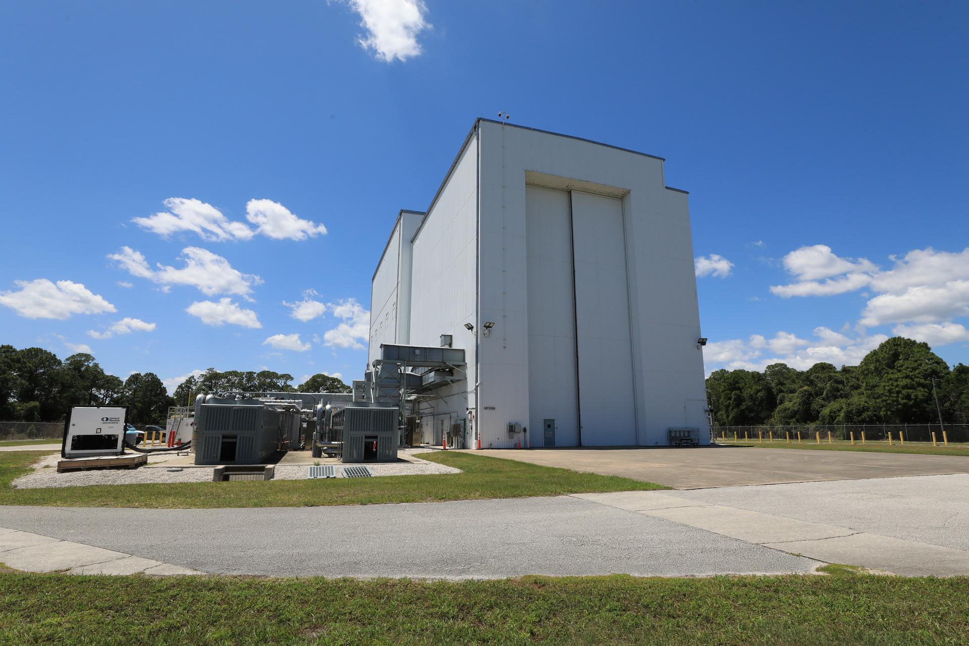
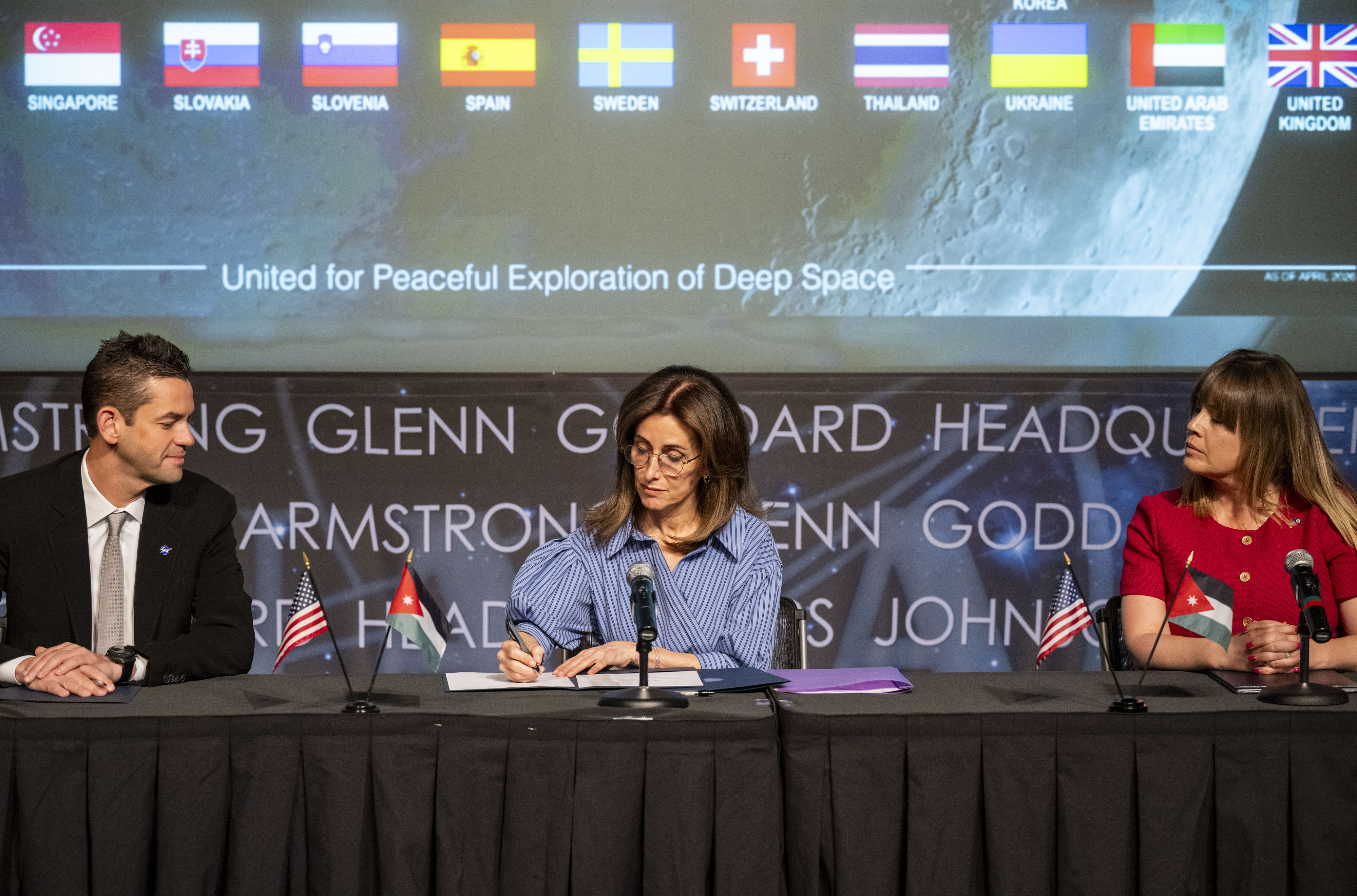
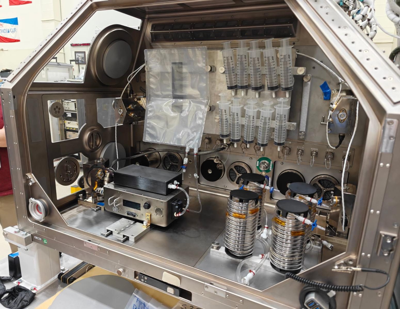
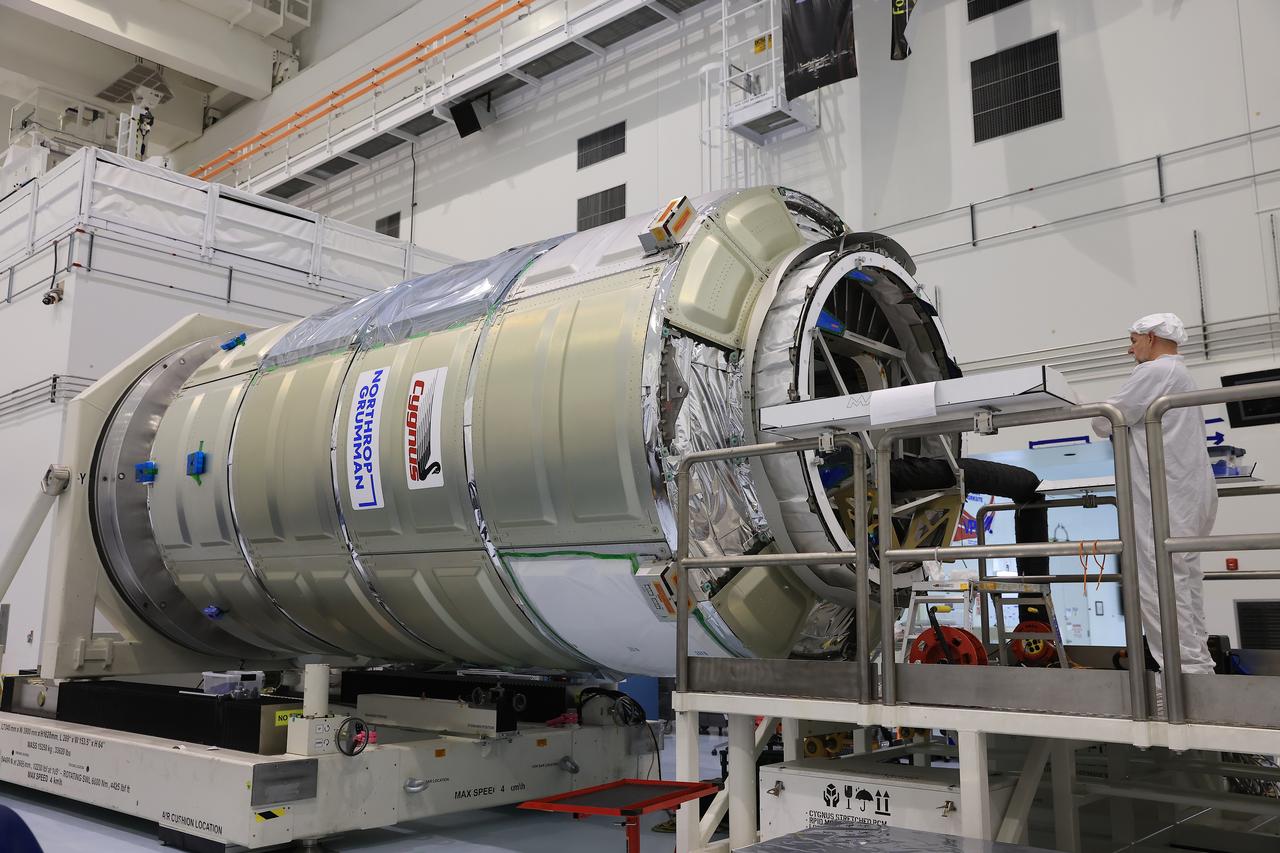
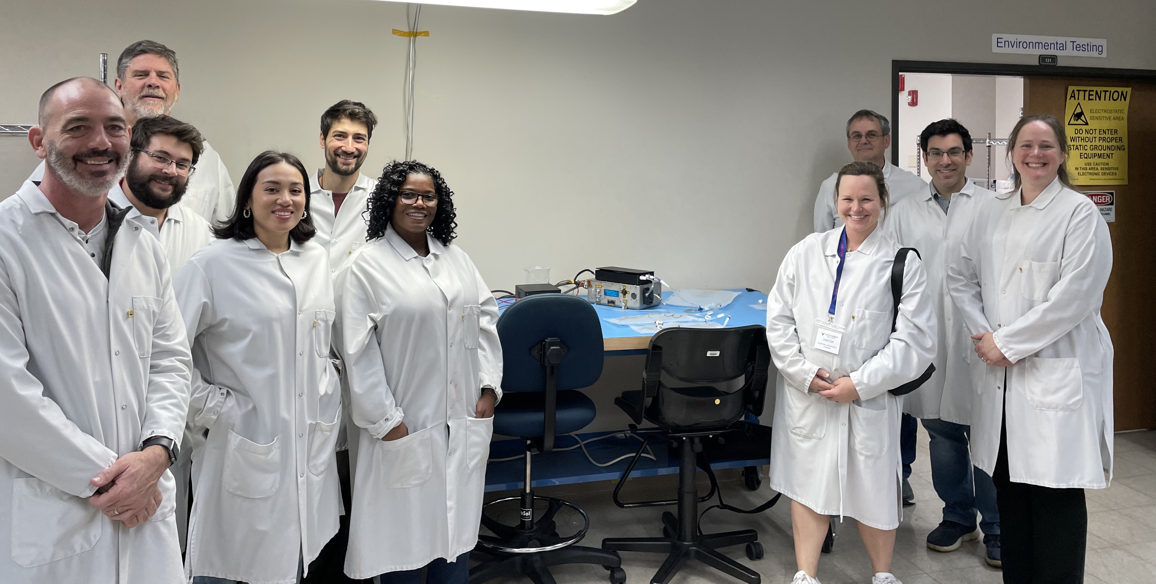
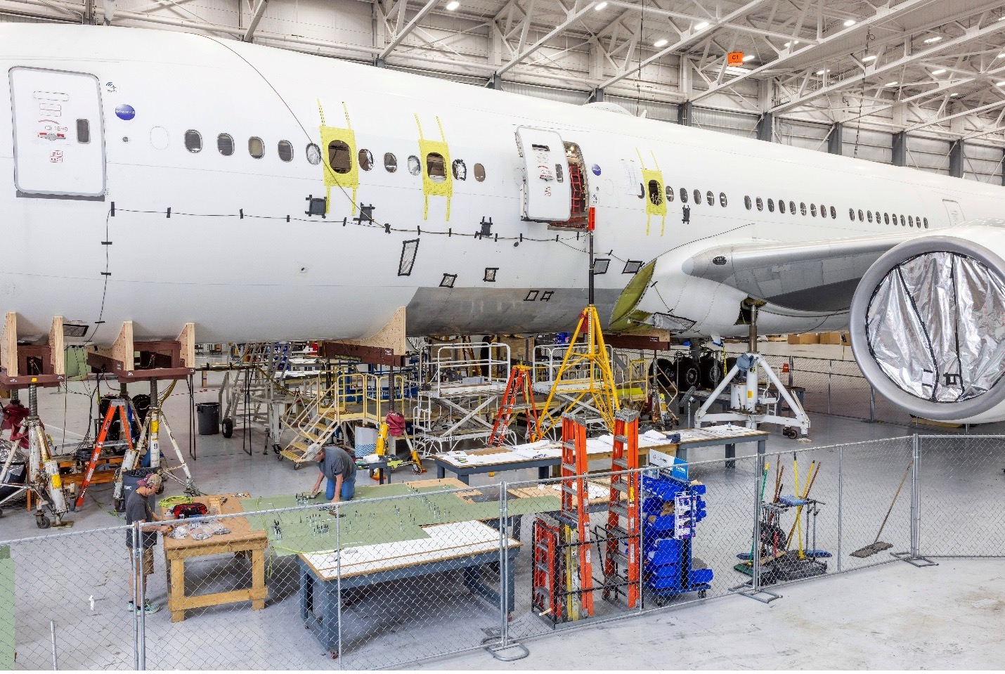
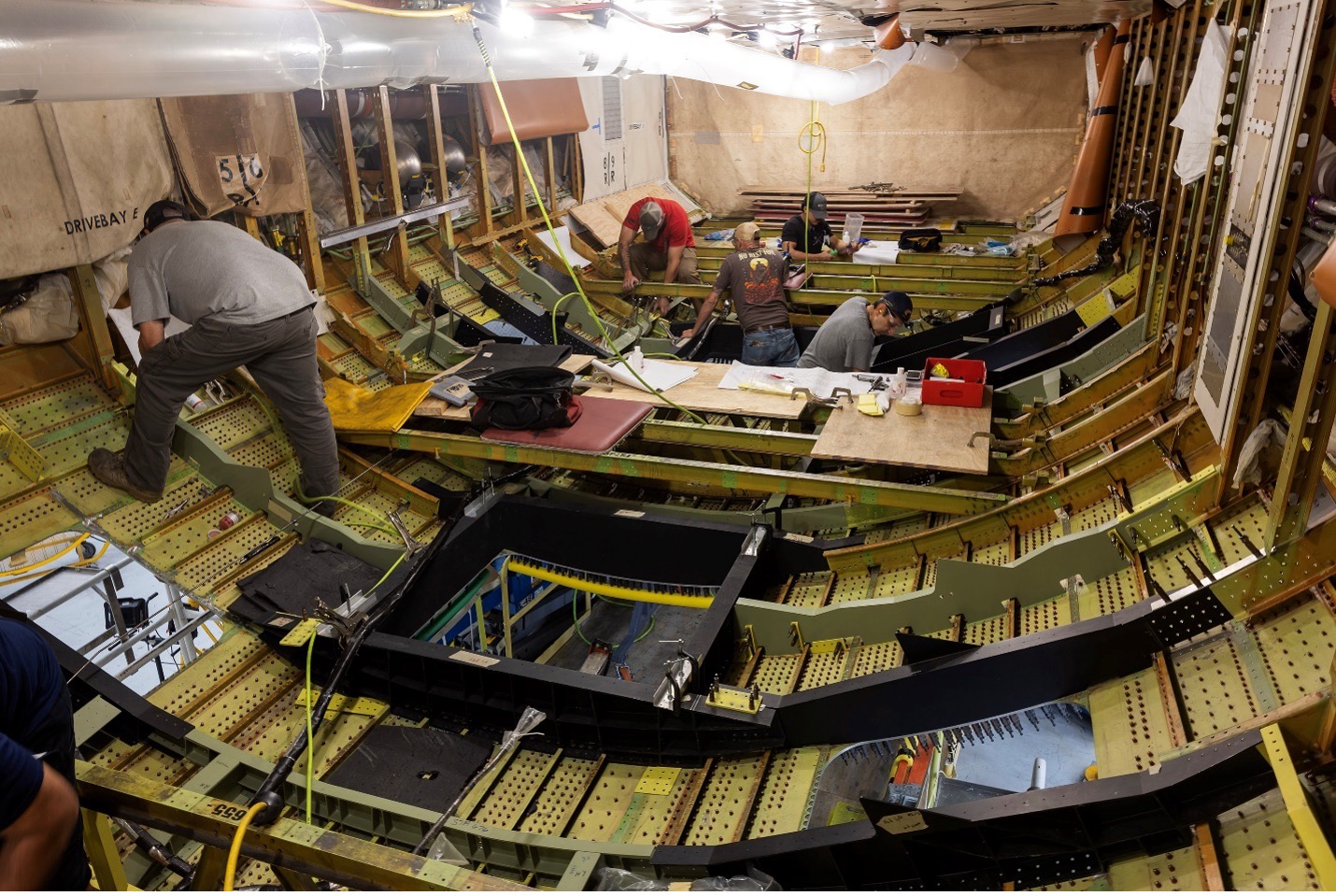
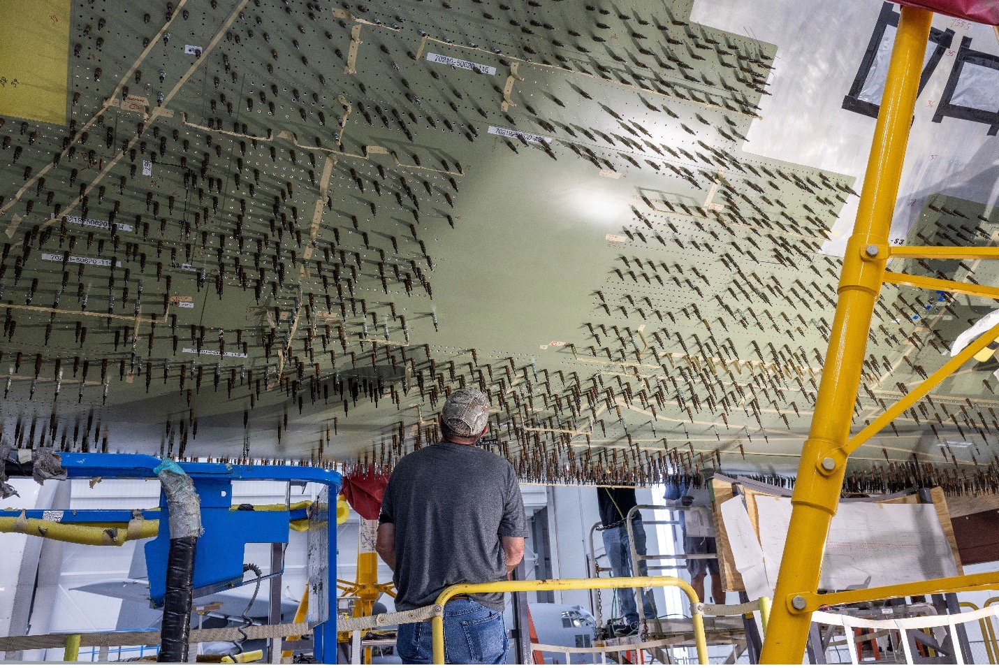
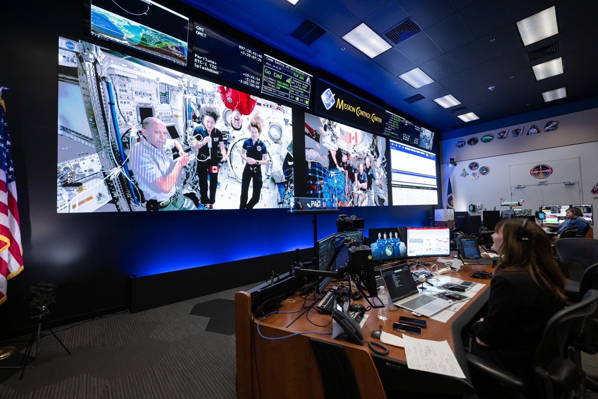
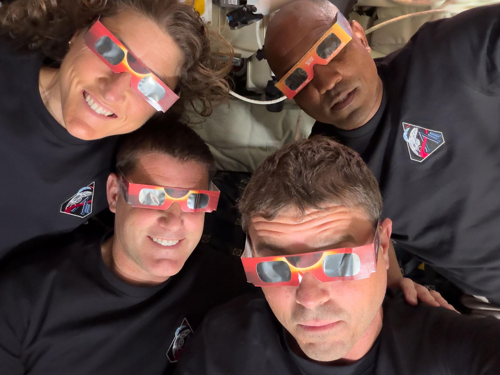
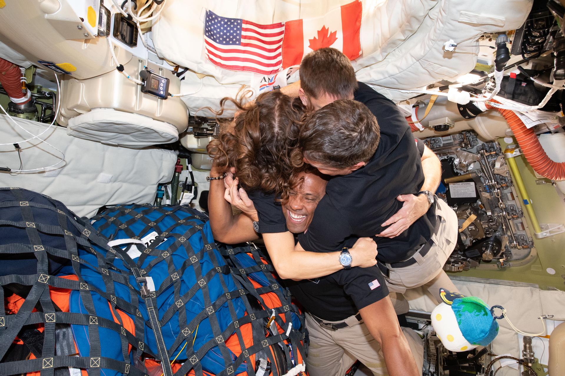
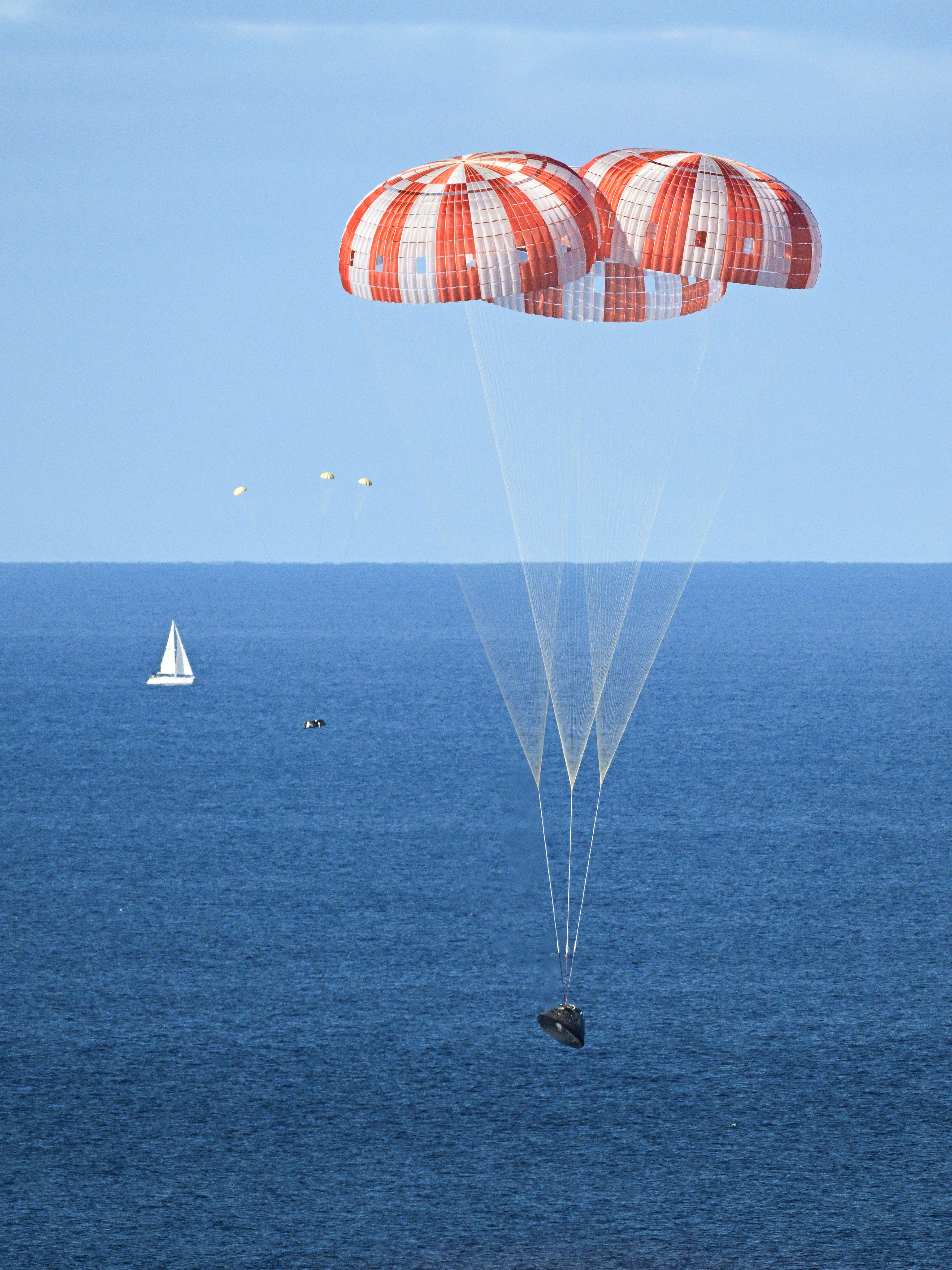
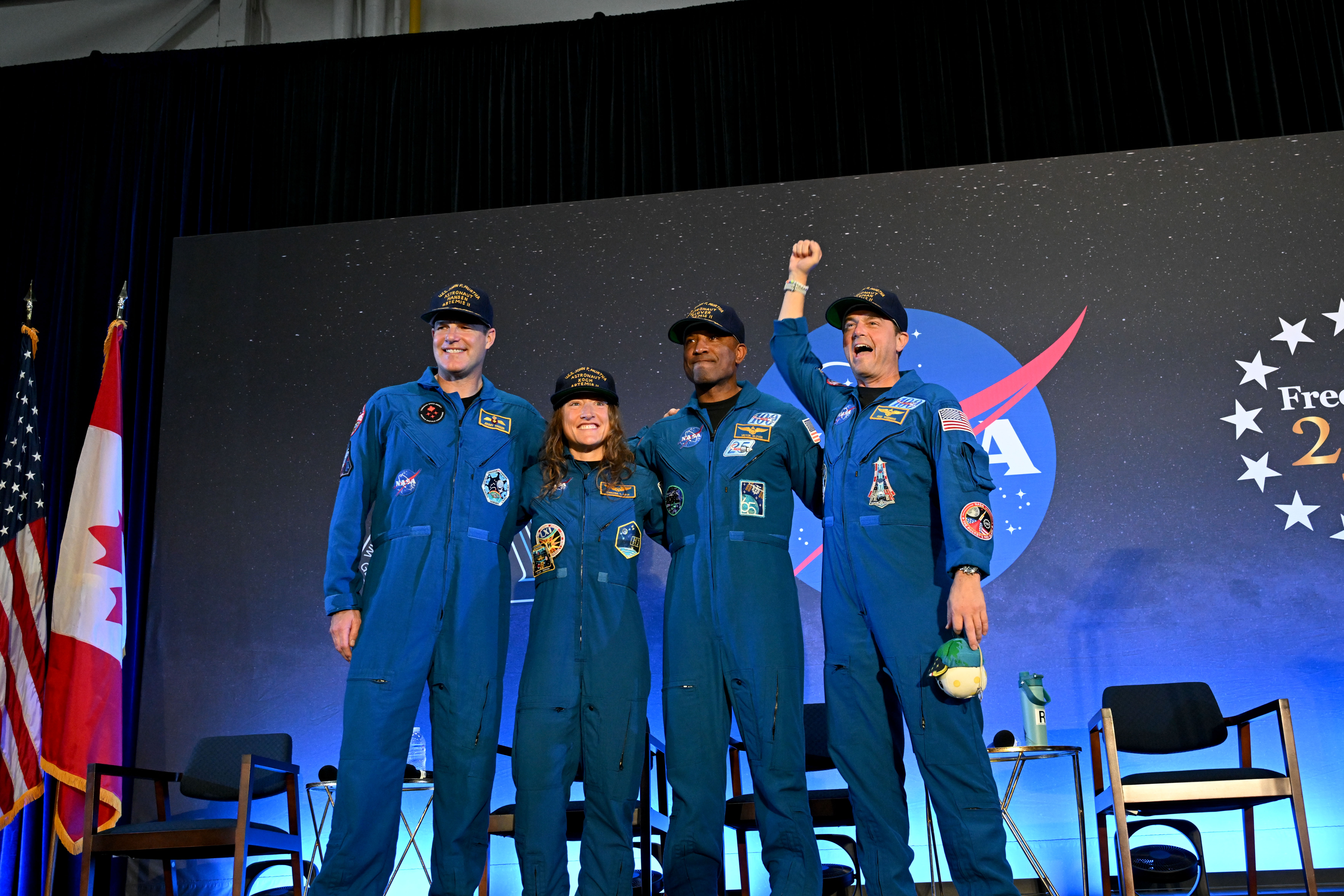
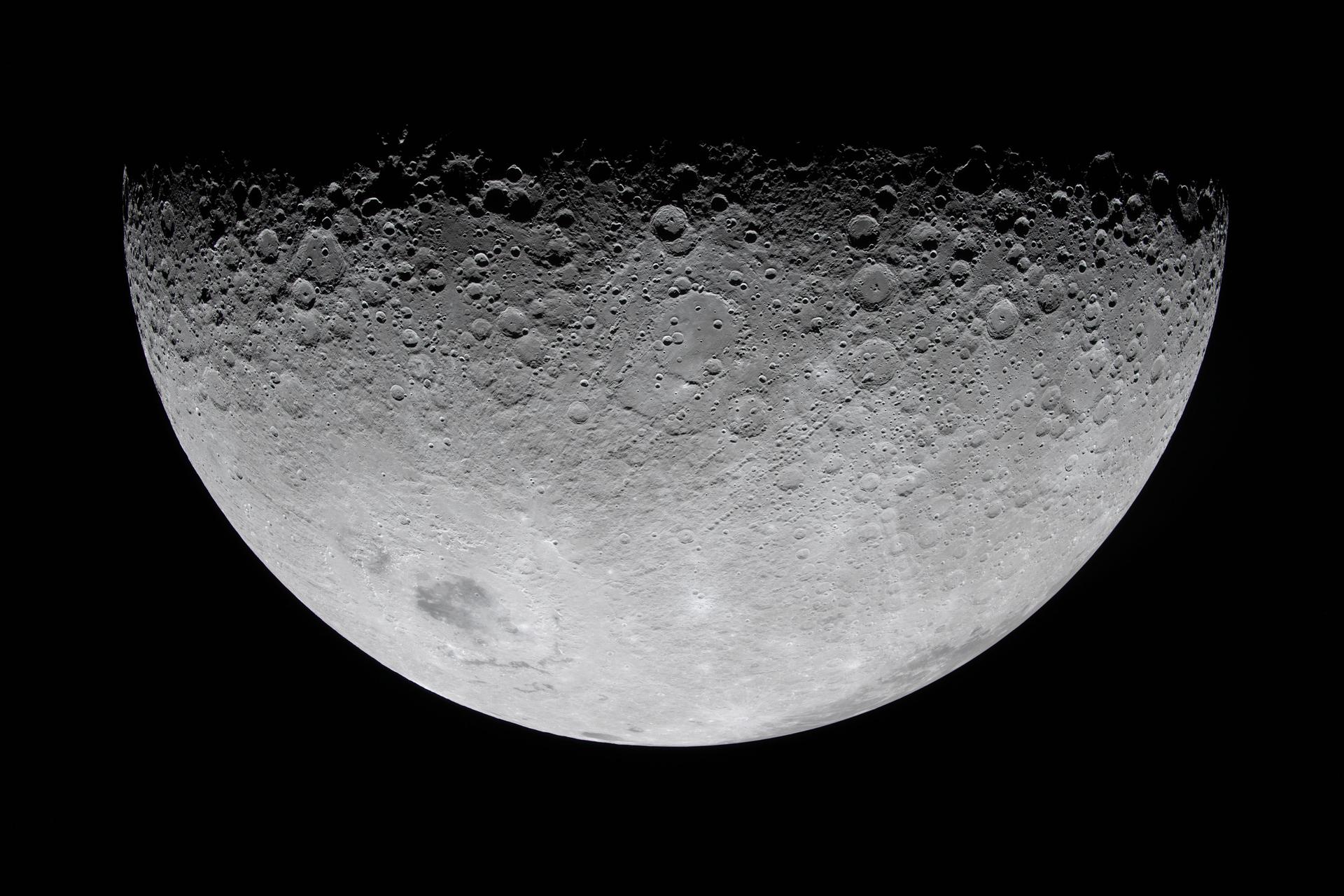
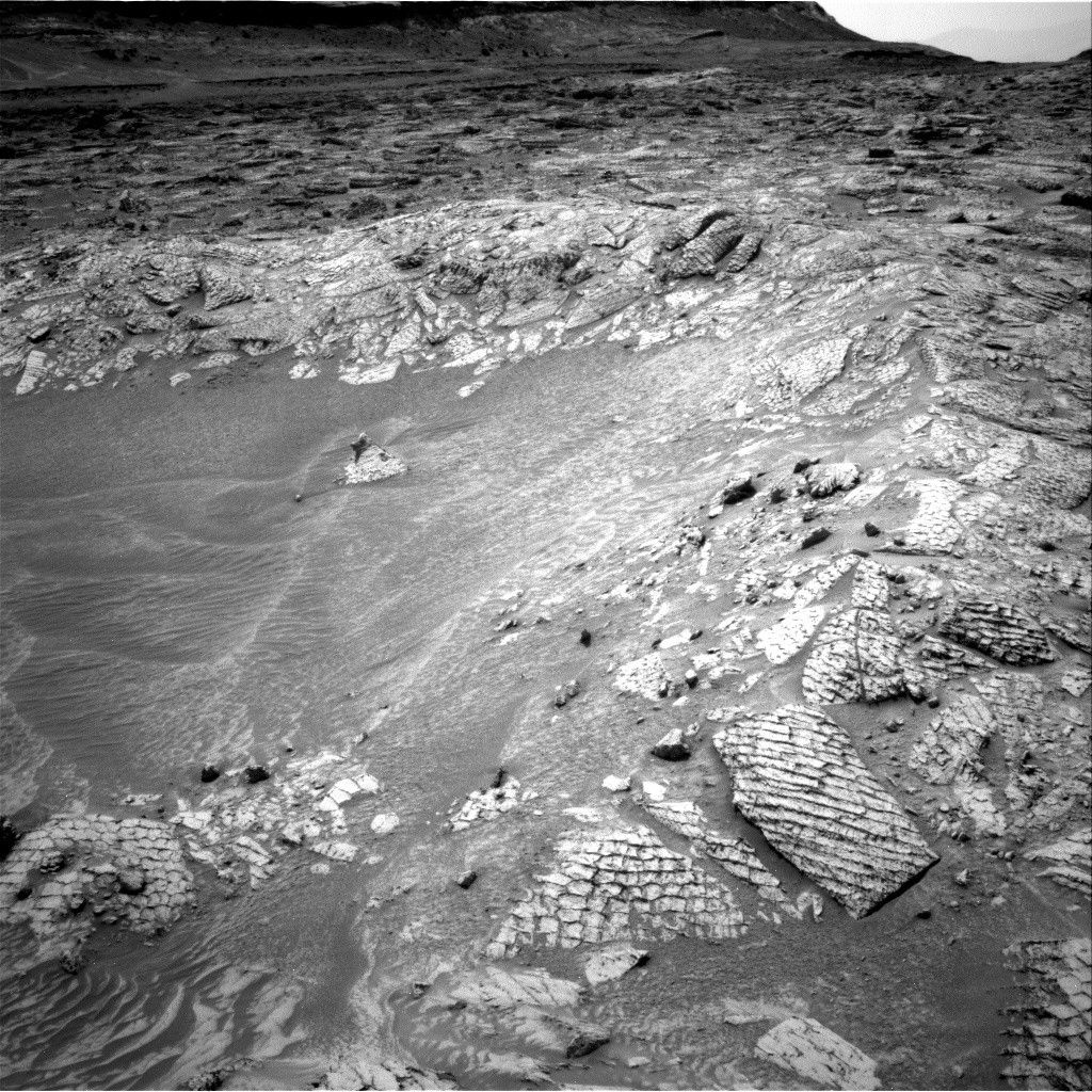