
NASA News
Winter’s End Is Written in the Clouds
- Earth
- Earth Observatory
- Image of the Day
- EO Explorer
- Topics
- More Content
- About
I Am Artemis: Ryan Schulte
Listen to this audio excerpt from Ryan Schulte, Orion flywheel project manager:
0:00 / 0:00
Your browser does not support the audio element.As the four Artemis II astronauts traveled on a 694,481-mile journey around the Moon and back, the Orion spacecraft provided them with all the essentials for deep space life, including daily exercise. The crew used an exercise device called the flywheel throughout their mission to maintain their physical and mental health, and Ryan Schulte, Orion flywheel project manager, led the team responsible for developing the flywheel for the historic flight.
At NASA’s Johnson Space Center in Houston, Schulte oversees the team that designed, built, tested, and flew the flywheel used on Artemis II, and currently develops a fleet of more reusable exercise devices for future Artemis missions.
What we’re doing with this exercise device has a direct impact on the crew’s safety, health, and their mission success. I feel lucky to work on hardware that the crew is physically using, interacting with, and benefiting from on a daily basis.Ryan Schulte
Orion Flywheel Project Manager
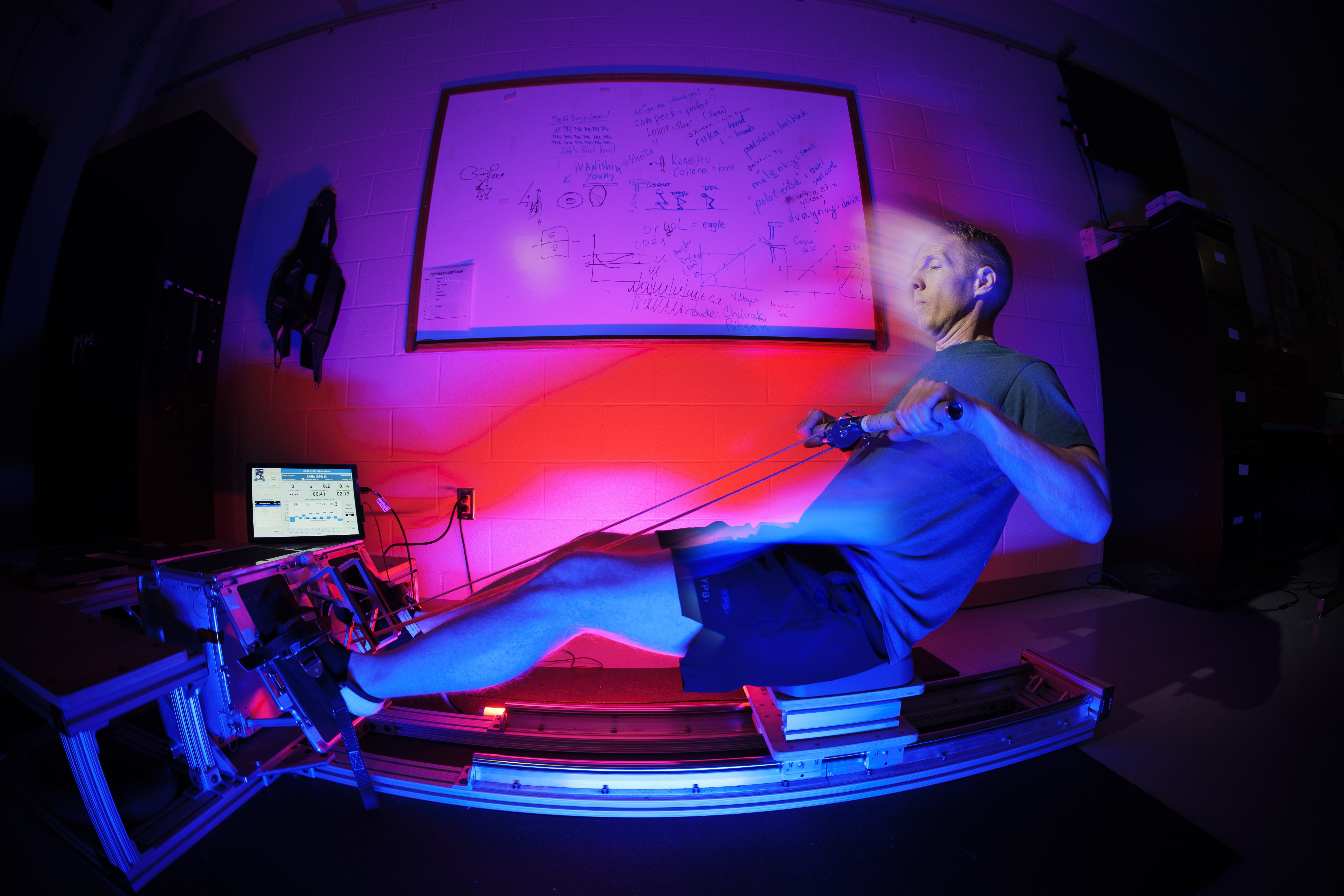
The flywheel is a compact, multi-functional device about the size of a large shoebox that provides the crew with a range of aerobic and resistive workouts without requiring any electrical power from the spacecraft.
“It works kind of like an inertial yo-yo,” said Schulte.
The user can select different gear ratios for different resistance modes, and the flywheel can provide ultimately up to 500 pounds of resistance.
“It’s really all dependent upon how much effort you put in. The crew can do squats, deadlifts, bent rows, high-pulls, curls, heel raises, and aerobic rowing all in one device.”
Developing the flywheel for Orion posed unique challenges for Schulte’s team, ranging from limited space and crew mobility to reducing noise generation for easy crew communication during workouts.
“One of the biggest challenges was trying to fit everything into this compact box, and also to be able to have enough space inside the rest of the capsule for someone to fully stand up and fully extend at high rates of speed and repetitions,” said Schulte.
The team’s successful response to these challenges was displayed during the approximately 10-day Artemis II mission, where the crew members exercised for roughly 30 minutes per day with the flywheel. The sessions helped to counteract both the physical and mental effects induced by a microgravity environment, which on future, longer-duration Artemis missions, will become an increasingly important component for astronauts.
Ryan Schulte, Orion flywheel project manager, demonstrates a rowing exercise on the Orion flywheel in the Exercise Countermeasures Lab at NASA’s Johnson Space Center in Houston.NASA/Rad Sinyak“Without Earth’s gravity, the crew’s muscles, bones, and stamina all begin to atrophy, or weaken,” Schulte said. “Exercise will help prevent injury as crews need to perform long lunar spacewalks on the surface or for emergency egress out of the capsule.”
Exercise with the flywheel also supports the crew’s mental health, providing psychological benefits while living in a compact space inside Orion.
“It’s a great form of stress relief,” Schulte said. “It improves their mental clarity by getting their fluids and their blood flowing, which can stagnate in your head in zero gravity. We’ve talked to some of the crew about how much clearer their minds feel after exercise in flight.”
Schulte began his career as a co-op at Johnson in 2007, then joined NASA full-time as a test engineer for pyrotechnics, propulsion, and power systems. He later transitioned to NASA’s Human Health and Performance Directorate and began working in the Human Research Program, where his interest in human interfaces with engineering grew, eventually leading him to his current role as the flywheel project manager.
With the success of Artemis II and the promise of future missions ahead, Schulte’s work on the flywheel and next generation exercise devices will play a vital role in keeping astronauts safe, healthy, and mission ready on the lunar surface and beyond.
I feel incredibly lucky to be doing what I get to do. There’s not a lot of people out there that get to do this type of work. It is really just an honor and a privilege to be able to serve my country in this way.Ryan Schulte
Orion Flywheel Project Manager
About the AuthorPenelope Lauren Garcia-Galan Share Details Last Updated Apr 29, 2026 Related Terms Explore More 4 min read NASA Laser Terminal Enhances Views During Artemis II Mission Article 2 days ago 3 min read I Am Artemis: Peter Rossoni Article 6 days ago 4 min read Johnson Leaders Honored by National Space Club & Foundation Article 7 days ago Keep Exploring Discover More Topics From NASAMissions
Humans in Space
Climate Change
Solar System
US-Indian Spacecraft Captures Mexico City Subsidence
NASA/JPL-Caltech/David Bekaert Photojournal Navigation Downloads US-Indian Spacecraft Captures Mexico City Subsidence
JPEG (32.05 MB)
PIA26709 Figure A
PNG (4.38 MB)
Description
A scientist produced this map of land subsidence (sinking) in Mexico City using data from the NISAR (NASA-ISRO Synthetic Aperture Radar) mission captured between Oct. 25, 2025, and Jan. 17, 2026. The region has been a well-known hot spot of subsidence for decades, and images like this help confirm that NISAR is performing as expected in its first year of operation.
The dark blue color indicates areas found to be subsiding by more than half an inch (more than 2 centimeters) per month, due in large part to groundwater pumping, which has led to compaction of the dry, ancient lakebed on which the city was built. The yellow and red areas are likely residual noise signals that are expected to decrease as NISAR collects more data and refines its measurements.
Two marshy ecosystems with ties to the country’s past can be seen in the image. The dark green oblong to the northeast of the airport is Nabor Carrillo, an artificial lake constructed over the now-extinct Lake Texcoco. Chalco Lake, a wetland located in a historically fertile region to the south, shares its name with a major body of water that was drained over a period of centuries to reduce flooding in the city. The ancient lake was a primary natural habitat of the Mexican Axolotl, an endangered species of salamander with the ability to regrow limbs.
Another landmark pinpointed in the image — the Angel of Independence along the Paseo de la Reforma — was built in 1910 to commemorate 100 years of Mexico’s independence. Standing over 100 feet (30 meters) tall, the monument has had 14 steps added to its base over the years as the land around it has gradually sunk.
Figure AFigure A is a version of the image extending further south and with no labels, scale, or compass.
The images were created with data from NISAR’s L-band radar instrument, which uses a 9-inch (24-centimeter) wavelength that enables its signal to penetrate dense vegetation such as forest canopies.
The satellite’s S-band radar, provided by the Indian Space Research Organisation’s Space Applications Centre, uses a 4-inch (10-centimeter) microwave signal that’s more sensitive to small vegetation, which makes it effective at monitoring certain types of agriculture and grassland ecosystems. Launched in 2025, NISAR is the first satellite to carry two SAR instruments at different wavelengths.
Data from NISAR will benefit humanity by helping researchers around the world better understand changes across our planet’s surface, from cities to forests and glaciers. The global and rapid coverage from NISAR will also provide unprecedented support for disaster response, producing data to assist in mitigating and assessing damage, with observations before and after catastrophic events available in short time frames.
Find more information about NISAR here: https://science.nasa.gov/mission/nisar/
Keep Exploring Discover More Topics From Photojournal
Photojournal
Search Photojournal
Photojournal’s Latest Content
Feedback
Curiosity Blog, Sols 4873-4878: Welcome to the Atacama Drill Target
- Curiosity Home
- Science
- News and Features
- Multimedia
- Mars Missions
- Mars Home
2 min read
Curiosity Blog, Sols 4873-4878: Welcome to the Atacama Drill Target NASA’s Mars rover Curiosity acquired this image using its Front Hazard Avoidance Camera (Front Hazcam) on April 23, 2026 — Sol 4874, or Martian day 4,874 of the Mars Science Laboratory mission — at 01:12:31 UTC. NASA/JPL-CaltechWritten by Sharon Wilson Purdy, Planetary Geologist at the Smithsonian National Air and Space Museum
Earth planning date: Friday, April 24, 2026
There was excitement in the air as the Curiosity Science Team kicked off a drill campaign at the Atacama site to characterize the first Mount Sharp layered-sulfate bedrock since leaving the boxwork terrain.
Monday was a three-sol plan (4873-4875) where we focused on “drill sol 1” activities that included a pre-load test on our drill target as well as triage contact science. APXS assembled a set of repeated observations on the Atacama drill target, and the coordinated MAHLI images taken with different lighting will provide an opportunity to detect possible changes between the datasets. Mastcam assembled stereo mosaics to document the Atacama drill site, investigate variations in the bedrock at “Kimsa Chata,” and characterize the layering within Paniri butte.
Planning resumed Friday with another three-sol plan (4876-4878) that included the full drill and portion characterization related to “drill sols 2 and 3” activities. Mastcam planned stereo mosaics of rocks in the workspace including a laminated rock with an exposed edge named “Queen of the Andes,” a rock with polygonal fractures that was broken when the rover drove over it named “Curaco,” and more coverage of the “El Almendrillo” target.
Rounding out the plans this week, the Environmental theme group continues to monitor dust in the atmosphere, study cloud movements, and document the presence of dust devils. The rover will also autonomously select two targets to be analyzed by the ChemCam instrument.
Next week we look forward to continuing our drill campaign, where the next step will be delivering a portion of the Atacama target to the ChemMin instrument for analysis. The science team is looking forward to seeing how the mineralogy of the layered sulfate unit here compares to our last drill of the same unit at the Mineral King site, which is nearly 160 meters (525 feet) below our current location!
-
Want to read more posts from the Curiosity team?
-
Want to learn more about Curiosity’s science instruments?
Article
1 week ago
3 min read Curiosity Blog, Sols 4859-4866: One Small Crater and Thousands of Polygons
Article
2 weeks ago
4 min read Curiosity Blog, Sols 4852–4858: When Data Take Their Time…
Article
2 weeks ago
Keep Exploring Discover More Topics From NASA Mars
Mars is the fourth planet from the Sun, and the seventh largest. It’s the only planet we know of inhabited…
All Mars Resources
Explore this collection of Mars images, videos, resources, PDFs, and toolkits. Discover valuable content designed to inform, educate, and inspire,…
Rover Basics
Each robotic explorer sent to the Red Planet has its own unique capabilities driven by science. Many attributes of a…
Mars Exploration: Science Goals
The key to understanding the past, present or future potential for life on Mars can be found in NASA’s four…
US-Indian Space Mission Maps Extreme Subsidence in Mexico City
One of the most powerful radar systems ever launched into space has mapped the ground moving beneath one of fastest subsiding capitals in the world: Mexico City. The findings show how quickly and reliably the NISAR (NASA-ISRO Synthetic Aperture Radar) satellite can track real-time changes across Earth’s surface from orbit, unhindered by clouds or vegetation that impede optical sensors and higher-frequency radars.
Home to some 20 million people, the Mexico City area is built atop an aquifer. Extensive groundwater pumping, combined with the weight of urban development, has resulted in the compaction of the ancient lakebed beneath the city for more than a century. An engineer first documented the issue in 1925, and by the 1990s and 2000s, parts of the metropolitan area were sinking by around 14 inches (35 centimeters) per year, damaging infrastructure including the Metro, one of the largest rapid transit systems in the Americas.
Several generations of space-based radar have tracked Mexico City on the move. The NISAR mission, launched in July 2025, is now advancing these efforts, analyzing fast-changing areas that are challenging to survey from space. Capable of working day and night, rain or shine, NISAR’s L-band synthetic aperture radar is designed to track subtle motions such as land sinking and rising, glaciers sliding, and croplands growing, as it passes overhead multiple times a month.
“Images like this confirm that NISAR’s measurements align with expectations,” said Craig Ferguson, deputy project manager at NASA Headquarters in Washington. “NISAR’s long wavelength L-band radar will make it possible to detect and track land subsidence in more challenging and densely vegetated regions such as coastal communities where they may have the compounding effects of both land subsidence and sea level rise.”
The new analysis is based on preliminary measurements taken by NISAR between October 2025 and January 2026, during Mexico City’s dry season. Parts of the region found to be subsiding by more than half an inch (more than 2 centimeters) per month are shown in dark blue. The yellow and red areas are likely residual noise signals that are expected to decrease as NISAR collects more data. The structure near the center of the image is Benito Juarez International Airport, with Lake Nabor Carrillo visible as a dark green oblong to the northeast.
One area landmark — the Angel of Independence along the Paseo de la Reforma — is a visible indicator of subsidence. Built in 1910 to commemorate 100 years of Mexico’s independence, the towering monument stands 114 feet (36 meters) high and has had 14 steps added to its base as the land around it gradually sinks.
“Mexico City is a well-known hot spot when it comes to subsidence, and images like this are just the beginning for NISAR,” said David Bekaert, a project manager at the Flemish Institute for Technological Research and a member of the NISAR science team. “We’re going to see an influx of new discoveries from all over the world, given the unique sensing capabilities of NISAR and its consistent global coverage.”
A joint mission developed by NASA and the Indian Space Research Organisation (ISRO), NISAR launched from Satish Dhawan Space Centre on India’s southeastern coast. Managed by Caltech, NASA’s Jet Propulsion Laboratory in Southern California leads the United States component of the project and provided the satellite’s L-band SAR and antenna reflector. The spacecraft bus and its S-band SAR were provided by ISRO.
The NISAR satellite is the first to carry two SAR instruments at different wavelengths and is monitoring Earth’s land and ice surfaces twice every 12 days, collecting data using the spacecraft’s giant drum-shaped reflector, which measures 39 feet (12 meters) wide — the largest radar antenna reflector NASA has ever sent into space.
To learn more about NISAR, visit:
https://science.nasa.gov/mission/nisar/
Media Contacts
Andrew Wang / Andrew Good
Jet Propulsion Laboratory, Pasadena, Calif.
626-379-6874 / 818-393-2433
andrew.wang@jpl.nasa.gov / andrew.c.good@jpl.nasa.gov
Written by Sally Younger
2026-027
Explore More 3 min read Winter’s End Is Written in the CloudsAs winter turned to spring, the skies over the Gulf of Alaska displayed textbook examples…
Article 12 hours ago 3 min read US-Indian Spacecraft Captures Mexico City SubsidenceDescription A scientist produced this map of land subsidence (sinking) in Mexico City using data…
Article 19 hours ago 3 min read Fires Rage in GeorgiaFirefighters are battling two destructive blazes in the southern part of the state as drought…
Article 1 day ago Keep Exploring Discover More Topics From NASA Mission: NISARWhen did NISAR launch? July 30, 2025 Where is NISAR? 464 miles (747 km) from Earth What does NISAR do?…
Water | Earth — A Photo-EssayWe shall not cease from exploration, and the end of all our exploring will be to arrive where we started…
Jet Propulsion Laboratory
EarthYour home. Our Mission. And the one planet that NASA studies more than any other.
A Gently Glowing Galaxy
A luminous swirl set against the deep black of space, the barred spiral galaxy IC 486 glows with a soft, ethereal light in this NASA Hubble Space Telescope image from April 13, 2026.
IC 486 lies right on the edge of the constellation Gemini (the Twins), around 380 million light-years from Earth. Classified as a barred spiral galaxy, it features a bright central bar-shaped structure from which its spiral arms unfurl, wrapping around the core in a smooth, almost ring-like pattern.
Read more about IC 486 and how scientists are studying galaxies using observations like this.
Image credit: ESA/Hubble & NASA, M. J. Koss, A. J. Barth
NASA, Boeing Advance Truss-Braced Wing Research in Test
3 min read
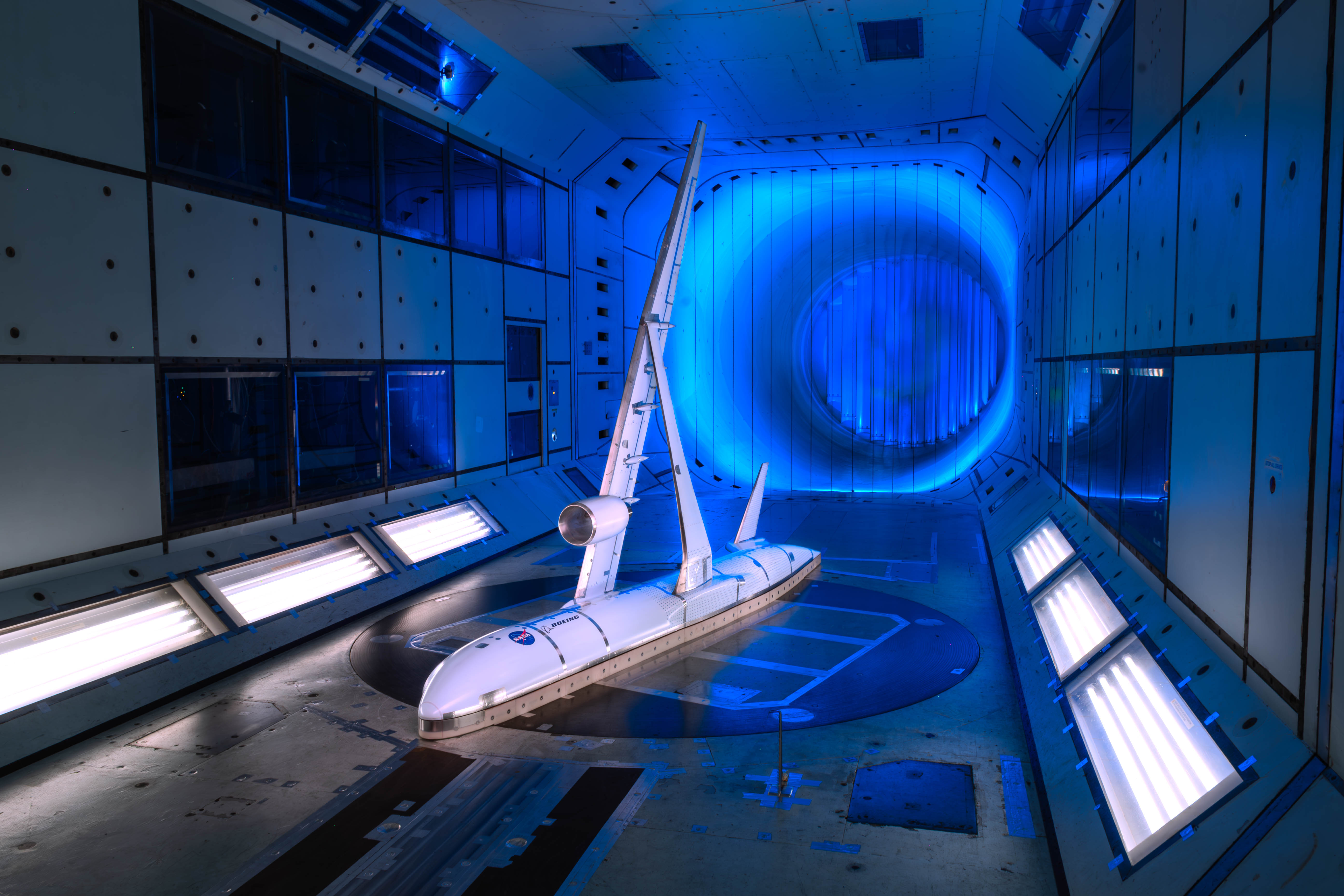
Preparations for Next Moonwalk Simulations Underway (and Underwater) A scale model of Boeing’s Subsonic Ultra Green Aircraft Research concept undergoes testing in a 5-meter wind tunnel operated by the company QinetiQ in December 2025.QinetiQNASA and Boeing have completed wind tunnel testing to study an innovative advanced aircraft design intended to improve aerodynamic efficiency.
A truss-braced wing configuration, involving a long, thin wing with aerodynamically shaped structural supports, has the potential to reduce fuel and operational costs for future airliners, which is why NASA has collaborated with Boeing to advance the design.
But this kind of wing would be much more than a simple tweak to existing designs – for an aircraft the size of a passenger jet, it would be a revolutionary redesign, requiring extensive study from NASA and Boeing.
The most recent round of testing used a complex wind tunnel model to collect data on how air flows around a truss-braced wing model and the forces that would be exerted on such a wing in flight.
The test used a semispan model – essentially half an aircraft mounted on a wind tunnel floor. The model has features built in to simulate the mechanisms that increase the amount of lift a wing produces. By adjusting the model’s slats, flaps, and other moving control surfaces, the team can configure it to the low speed, high-lift settings of takeoff and landing conditions.
The model is part of a collaboration to test what’s known as Boeing’s Subsonic Ultra Green Aircraft Research (SUGAR) concept.
In December, teams completed testing of the model wind tunnel operated by the company QinetiQ in Farnborough, England. This large wind tunnel uses pressurized conditions to predict airplane behavior in takeoff and landing conditions.
The large size of the tunnel gives the model fidelity to better predict the behavior of a plane in flight. This capability allowed the team to confidently assess aerodynamic performance.
NASA and Boeing research teams analyzed data in real time to ensure the model performed as expected. Researchers are still reviewing the full results, but the test has already added valuable information to a growing body of research aimed at reducing fuel use in future aircraft designs.
The testing was just the latest stop for this research. NASA and Boeing have tested the concept at multiple NASA facilities to collect data as they work to build a comprehensive understanding of this advanced airframe concept.
This collaboration serves as an example of how NASA serves as an incubator for breakthrough technology with profound commercial applications. The transonic truss-braced wing concept originated from NASA aeronautics-supported research and NASA and Boeing engineers have worked together, test-by-test, to move this wing design from an idea to a practical reality.
The work began in NASA’s Advanced Air Vehicles Program and continues as part of the Subsonic Flight Demonstrator project under the Integrated Aviation Systems Program in the agency’s Aeronautics Research Mission Directorate.
Share Details Last Updated Apr 29, 2026 EditorDede DiniusContactSarah Mannsarah.mann@nasa.gov Related Terms Explore More 4 min read There’s No Place Like NASA’s New X-59 Hangar Home Article 2 days ago 5 min read NASA Fires Up Powerful Lithium-Fed Thruster for Trips to Mars Article 2 days ago 4 min read NASA Laser Terminal Enhances Views During Artemis II Mission Article 2 days ago Keep Exploring Discover More Topics From NASANASA Armstrong Flight Research Center
Humans in Space
Climate Change
Aeronautics
NASA Demonstrates New Prescribed Burn Capability for Spaceport
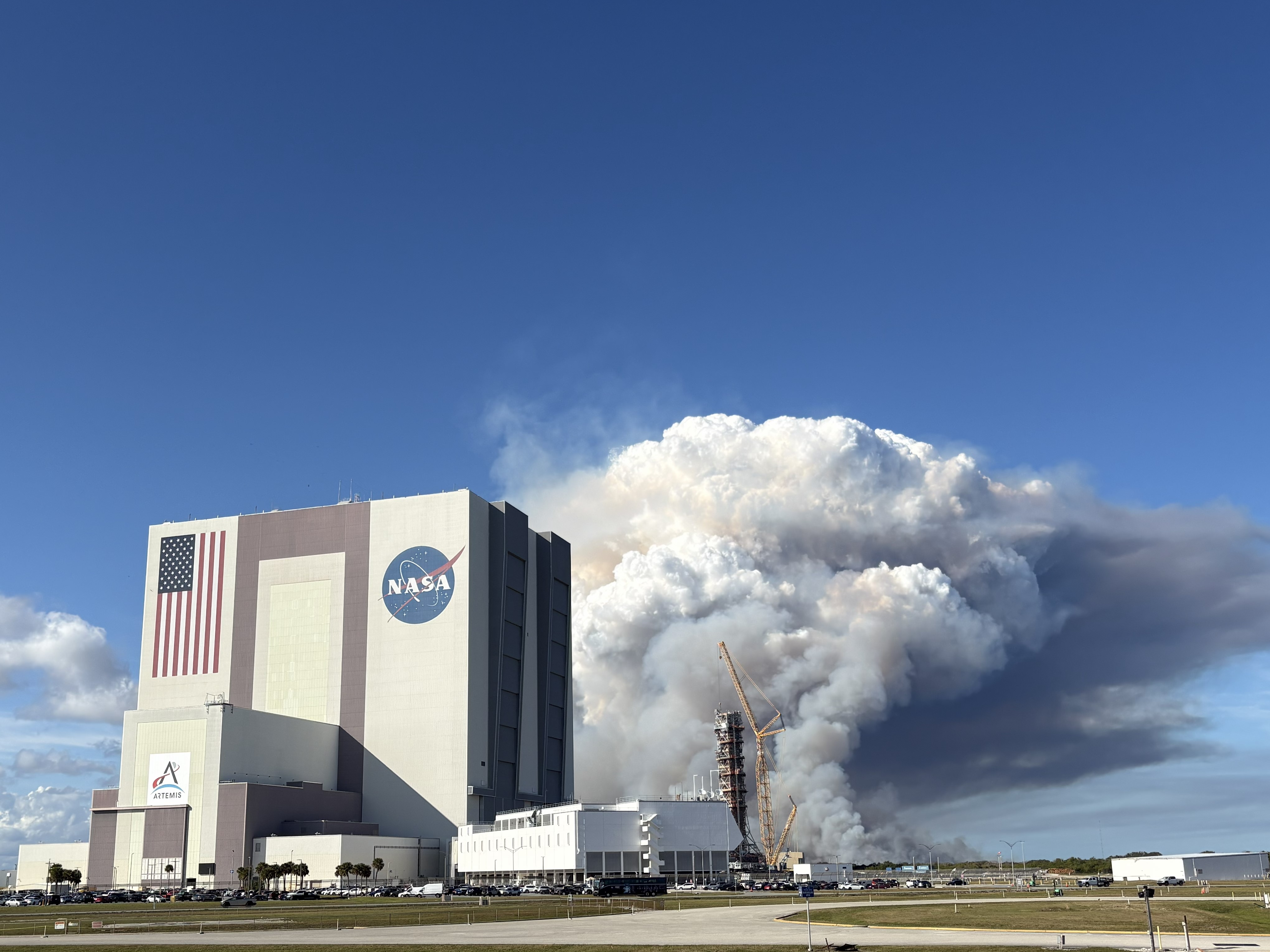
Anyone who has seen a launch at NASA’s Kennedy Space Center in Florida knows the agency’s pursuit of the stars involves some smoke and fire. Sometimes, however, the smoke doesn’t come from the rockets that propel astronauts beyond Earth’s bounds.
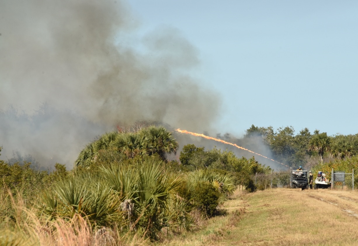
That was the case during the second weekend of January 2026, when NASA teamed up with the U.S. Fish and Wildlife Service and commercial space partners to intentionally ignite around 2,600 acres of scrub habitat at NASA Kennedy during an active launch countdown, a first for the busiest spaceport in the world.
Staff from NASA Kennedy’s Spaceport Integration Directorate oversaw two prescribed burns conducted by the Service. The larger burn affected around 1,400 acres on the northeast corner of the center, known as Happy Creek — a key habitat for the federally protected Florida scrub-jay and other wildlife that rely on periodic wildfires to thrive.
The other prescribed burn affected a 1,200-acre section east of Kennedy Parkway and south of the center’s industrial zone, near the spaceport’s seven-story headquarters building, as well as iconic facilities critical to NASA’s past and future space efforts like the Neil A. Armstrong Operations and Checkout Building and the Space Systems Processing Facility.
Historically, the center paused launch operations when using fire as a land management tool within NASA Kennedy’s secure area or the Merritt Island National Wildlife Refuge, which surrounds it. However, with Kennedy’s spaceport surpassing 100 successful liftoffs for the first time in 2025, and with the launch cadence expected to continue climbing in the years to come, officials at both agencies recognized the need to adapt.
NASA and U.S. Fish and Wildlife Service personnel gather at the United States Fish and Wildlife Service off A. Max Brewer Memorial Parkway on Friday, Jan. 9, 2026, in Titusville, Florida to finalize the plan prior to the prescribed burn.NASA/Tim Kozusko“As more launches occur at Kennedy, the need for proper land management at the refuge has never been greater,” said Greg Gaddis, the center’s senior operations manager for the spaceport. “We must find new ways to lessen the amount of fire fuel on the ground while also keeping pace with the launch needs of our government and commercial partners. Otherwise, an unexpected lightning bolt or some other fire-starter could be catastrophic for America’s space ambitions, as well as the private space industry.”
The increasing launch cadence is one of many factors the prescribed burn manager — also known as the burn boss — must consider when deciding when and where to conduct a prescribed burn at the spaceport. Another critical factor is weather conditions, especially during Florida’s dry season, where constant breeze from the nearby Atlantic Ocean can quickly turn a small fire into a large one. This could potentially pose a significant risk to plant and animal species at the refuge, as well as to the center’s launch infrastructure.
Safety remains the paramount concern. The center’s Space Operations Office worked directly with the Service and the launch mission partners during the burn.
Prior to the Service setting prescribed burns with air and land resources, Kennedy officials reviewed forecasted wind patterns and developed plans to protect workers in buildings affected by the smoke. The center issued smoke warnings, temporarily relocated some personnel, and allowed others to work remotely during the burns. The smoke also caused intermittent closures of some of the center’s main roads and entrances throughout the weekend for safety reasons.
Torches mounted onto vehicles are used to intentionally set over 2,600 acres of the Merritt Island National Wildlife Refuge on fire on Friday, Jan. 9, 2026. Those areas are located inside Kennedy Space Center’s restricted area and occurred during an active launch countdown, the first time that’s ever happened at NASA Kennedy. NASA/Tim Kozusko“To do is to learn, and we all learn each day,” said Shawn Sullivan, assistant fire management officer for the Service’s Region 4 and the designated burn boss. “I stood in awe of the people working around me. To listen to the coordination between specialized groups and witness great individual effort was quite an experience.”
Conducting prescribed burns every two or three years is optimal for maintaining the health and resilience of the refuge, especially for wildlife like the Florida scrub-jay, which has adapted to periodic fires. Determining when and where to conduct these burns is one of the most challenging parts for the burn boss and the officials responsible for operating the spaceport. The amount of vegetation in those areas is often a deciding factor when choosing what to burn.
“We want to make sure those areas don’t get clogged up, making it more difficult for firefighters to gain access if they have to protect launch pads or any other infrastructure from a wildfire,” Gaddis added. “It also leaves less fuel a wildfire can use to grow, and that’s always a big help for first responders working to put a fire out.”
Council on Environmental Quality Permitting Innovators Program
NASA’s Center of Excellence for Collaborative Innovation (CoECI) assists in the use of crowdsourcing across the federal government. CoECI’s NASA Tournament Lab offers the contract capability to run external crowdsourced challenges on behalf of NASA and other agencies.
The Council on Environmental Quality (CEQ), within the Executive Office of the President established by the National Environmental Policy Act (NEPA) in 1970, consults and coordinates with federal agencies, providing guidance on the implementation of NEPA to ensure timely environmental review and permitting processes across the Federal government
Technology solutions could accelerate and modernize environmental review and permitting by connecting data, systems, and processes — enhancing collaboration between agencies and the American public. As part of CEQ’s mandate to ensure timely environmental review across the federal government, CEQ and partner agencies have identified technology gaps outlined in the Permitting Technology Action Plan. However, meeting the bold goals and timeline set by the presidential memorandum will require deeper collaboration among industry and government.
CEQ’s Permitting Innovation Center invites participants to the Permitting Innovators program to share tech solutions that will accelerate and modernize federal environmental review and permitting. CEQ will evaluate eligible submissions and invite a select group of applicants to participate in the inaugural Permitting Innovators Expo in July, where they will demo solutions to federal agency staff and the broader environmental review and permitting community. Top solutions will also be featured in the Permitting Innovators Solutions Catalog.
Open date: April 28, 2026
Submission deadline: June 2, 2026 at 6:00 p.m. ET
For more information, visit: https://www.permittinginnovators.com/
Fires Rage in Georgia
- Earth
- Earth Observatory
- Image of the Day
- EO Explorer
- Topics
- More Content
- About
NASA Connects Little Red Dots with Chandra, Webb
A newly discovered object may be a key to unlocking the true nature of a mysterious class of sources that astronomers have found in the early universe in recent years.
A “X-ray dot” found by NASA’s Chandra X-ray Observatory could explain what the hundreds or potentially thousands of these objects are. A paper describing the results published in The Astrophysical Journal Letters.
Shortly after NASA’s James Webb Space Telescope started its science observations, reports of a new class of mysterious objects emerged. Astronomers found small, red objects about 12 billion light-years from Earth or farther, which became known as “little red dots” (LRDs).
Many scientists think LRDs are supermassive black holes embedded in clouds of dense gas, which mask some of the typical signatures in different kinds of light – including X-rays – that astronomers usually use to identify them. This would make them different from typical growing supermassive black holes, which are not embedded in dense gas, allowing bright ultraviolet light and X-rays from material orbiting the black holes to escape.
Because of this and their potential similarities to stellar atmospheres, astronomers have called this the “black hole star” scenario for LRDs.
This new “X-ray dot” (officially known as 3DHST-AEGIS-12014), which is located about 11.8 billion light-years from Earth, may provide a crucial bridge between black hole stars and typical growing supermassive black holes. It exhibits most of the features of an LRD, including being small, red, and located at a vast distance, but it glows in X-ray light, unlike other LRDs.
“Astronomers have been trying to figure out what little red dots are for several years,” said lead author Raphael Hviding of the Max Planck Institute for Astronomy in Germany. “This single X-ray object may be – to use a phrase – what lets us connect all of the dots.”
Artist’s Illustration of a Close-Up View of X-ray Dot, 3DHST-AEGIS-12014. NASA/CXC/SAO/M. Weiss; adapted by K. Arcand & J. MajorThe team found this one special object after comparing new data from Webb with a deep survey previously performed by Chandra.
“If little red dots are rapidly growing supermassive black holes, why do they not give off X-rays like other such black holes?” said co-author Anna de Graaff of the Center for Astrophysics | Harvard & Smithsonian, in Cambridge, Massachusetts. “Finding a little red dot that looks different from the others gives us important new insight into what could power them.”
The researchers suggest that the X-ray dot represents a transition phase from an LRD to a typical growing supermassive black hole. As the black hole star consumes its surrounding gas, patchy holes in the clouds of gas appear. This allows X-rays from material falling onto the black hole to poke through, which are observed by Chandra. Eventually all the gas is consumed, and the black hole star ceases to exist.
There are also hints in the Chandra data of the X-ray dot that there are variations in X-ray brightness, which supports the idea that the black hole is partly obscured. As the cloud of gas rotates, patches of denser and less dense gas can move across the black hole, causing changes in X-ray brightness.
“If we confirm the X-ray dot as a little red dot in transition, not only would it be the first of its kind, but we may be seeing into the heart of a little red dot for the first time,” said co-author Hanpu Liu of Princeton University in New Jersey. “We would also have the strongest piece of evidence yet that the growth of supermassive black holes is at the center of some, if not all, of the little red dot population.”
An alternate idea for the X-ray dot is that it is a more common type of growing supermassive black hole but is veiled in an exotic type of dust that astronomers have not seen before. Future observations are planned that should be able to shed light on the truth.
“The X-ray dot had been sitting in our Chandra survey data for over ten years, but we had no idea how remarkable it was before Webb came along to observe the field,” said co-author Andy Goulding of Princeton. “This is a powerful example of collaboration between two great observatories.”
NASA’s Marshall Space Flight Center manages the Chandra program. The Smithsonian Astrophysical Observatory’s Chandra X-ray Center controls science operations from Cambridge, Massachusetts, and flight operations from Burlington, Massachusetts.
Read more from NASA’s Chandra X-ray Observatory
Learn more about the Chandra X-ray Observatory and its mission here:
https://science.nasa.gov/chandra
News Media ContactMegan Watzke
Chandra X-ray Center
Cambridge, Mass.
617-496-7998
mwatzke@cfa.harvard.edu
Joel Wallace
Marshall Space Flight Center, Huntsville, Alabama
256-544-0034
joel.w.wallace@nasa.gov
There’s No Place Like NASA’s New X-59 Hangar Home
4 min read
Preparations for Next Moonwalk Simulations Underway (and Underwater) NASA’s X-59 quiet supersonic airplane sits parked in front of its new hangar home at the agency’s Armstrong Flight Research Center in California. The facility originally was constructed in 1968 and for nearly 60 years has hosted a number of research aircraft and programs.NASA/Christopher LC ClarkThere’s no sign reading “home sweet home” in the hangar where the X‑59 now sits, but the sentiment is unmistakable among those tending to the quiet supersonic aircraft.
Located at NASA’s Armstrong Flight Research Center in Edwards, California, the X-59 hangar was built in 1968 but looks like new thanks to a full renovation and modernization. While the X-59 was being assembled in Palmdale, California, workers at NASA Armstrong gutted the hangar, adding new electrical wiring, a fire suppression system, office space, air conditioning, and other safety features.
“The whole team is incredibly proud of what we’ve accomplished in preparing this new home for the X-59,” said Bryan Watters, the NASA project manager at Armstrong who led the renovation effort. “The fact we could take a 1960s hangar and modernize it for use by a 2020’s X-plane is very special.”
The X-59 is the centerpiece of NASA’s Quesst mission to enable a new era of commercial supersonic air travel over land by reducing the sound of typically loud sonic booms to a much quieter sonic thump.
Home huntingWhen NASA test pilot Nils Larson successfully took the X-59 into the air for the first time on Oct. 28, 2025, he flew from the Lockheed Martin Skunk Works assembly site in Palmdale to nearby NASA Armstrong, from where test flights have continued to make progress.
From the beginning of the program, knowing the X-59 would eventually need a new residence at NASA Armstrong, Quesst managers were on the hunt for somewhere to house the quiet supersonic demonstrator.
Like anyone looking for the ideal place to call home, the team made sure there would be enough space for the airplane and all its support equipment. But with the experimental jet measuring at just under 100 feet long and 30 feet wide, there were few options.
“We had to find a hangar that was long enough so that part of the X-59 wouldn’t hang outside, exposed to the elements,” Watters said.
Building 4826, as the hangar is officially designated, turned out to be the choice spot. “It was basically stripped down and gutted so that essentially it was just structural steel with siding. From that state it was rebuilt,” Watters said.
The feature they are perhaps most proud of is the hangar’s new floor. Covering more than 32,000 square feet, it is coated with epoxy that prevents any spills from seeping into the concrete.
From the hangar’s office windows, the view of the hangar floor can include the F-15 research jets that will be used as chase planes to support X-59 flights in the coming months. The renovation faced challenges along the way, chief among them being supply chain issues stemming from the COVID-19 pandemic. But there were some incredible, unforgettable moments too.
Circa 1990 Nov. 2025 On loan to NASA from the Air Force, an F-15 Eagle fighter jet was the focus of the Short Takeoff and Landing/Maneuver Technology Demonstrator research program, which concluded in 1991. The aircraft is seen here inside Building 4826, a hangar at NASA’s Armstrong Flight Research Center that was renovated and began use in 2025 as home for the X-59 quiet supersonic technology demonstrator.NASA NASA’s X-59 quiet supersonic technology demonstrator aircraft is seen parked inside its new hangar home at the agency’s Armstrong Flight Research Center in California.NASA/Christopher LC Clark Circa 1990Nov. 2025 On loan to NASA from the Air Force, an F-15 Eagle fighter jet was the focus of the Short Takeoff and Landing/Maneuver Technology Demonstrator research program, which concluded in 1991. The aircraft is seen here inside Building 4826, a hangar at NASA’s Armstrong Flight Research Center that was renovated and began use in 2025 as home for the X-59 quiet supersonic technology demonstrator.NASA NASA’s X-59 quiet supersonic technology demonstrator aircraft is seen parked inside its new hangar home at the agency’s Armstrong Flight Research Center in California.NASA/Christopher LC Clark Circa 1990 Nov. 2025past and present
Hangar Updated to Continue Hosting Historic Research CurtainToggle2-Up Image Details This NASA hangar at Armstrong Flight Research Center originally was constructed in 1968 and since then has hosted a number of history-making programs. Compare the two images above to see how the hangar looked during the late 1980s when it hosted an F-15 research aircraft (left), and beginning in 2025 after it had been renovated and modernized to host the X-59 quite supersonic technology demonstrator aircraft. Moved inWith X-59 now flying regularly and comfortably settled into its new digs, the Quesst team is gauging its performance on the way to quiet supersonic flight.
“This is truly a great time for Quesst and the X-59,” said Cathy Bahm, NASA’s project manager for the Low Boom Flight Demonstrator. “It’s also still a little surreal to be able to just walk down from your office and see the airplane in our hangar.”
For more than a year, the hangar refurbishment team worked through every detail of the X-59’s new home to make sure it would be safe and sound. But actually seeing the aircraft occupy that space is an adjustment for them, too.
“We’ve looked at X-59 models on our desk for years and then, you know, there’s the real thing right in front of us, in a hangar that we renovated,” Watters said.
A real thing in the hangar – and streaking across the California desert sky. The X-59’s transition from an idea into a working aircraft is a testament to the teams that help build out every aspect of its infrastructure.
NASA’s X-59 is supported under the agency’s Aeronautics Research Mission Directorate.
About the AuthorJim BankeManaging Editor/Senior WriterJim Banke is a veteran aviation and aerospace communicator with more than 40 years of experience as a writer, producer, consultant, and project manager based at Cape Canaveral, Florida. He is part of NASA Aeronautics' Strategic Communications Team and is Managing Editor for the Aeronautics topic on nasa.gov. In 2007 he was recognized with a Distinguished Public Service Medal, NASA's highest honor for a non-government employee.
Facebook logo @NASA@NASAArmstrong@NASAaero@NASA_es @NASA@NASAArmstrong@NASAaero@NASA_es Instagram logo @NASA@NASAArmstrong@NASAaero@NASA_es Linkedin logo @NASA Explore More 8 min read NASA Celebrates Decade of University Innovation in Aeronautics Article 5 days ago 4 min read NASA Releases Powerful LAVA Software to US Aerospace Industry Article 6 days ago 3 min read NASA’s 777 Aircraft Returns Home with Science Flights on the Horizon Article 7 days ago Keep Exploring Discover More Topics From NASAMissions
Artemis
Aeronautics STEM
Explore NASA’s History
Share Details Last Updated Apr 28, 2026 EditorDede DiniusContactKristen Hatfieldkristen.m.hatfield@nasa.govLocationArmstrong Flight Research Center Related TermsNighttime Imaging Grows Landsat’s Science Value
- Landsat Home
- Missions
- News
- Data
- Benefits
- Outreach
- Multimedia
- About
- Search
By Earth Resources Observation and Science (EROS) Center
For more than 50 years, Landsat has imaged Earth’s land and near-shore surfaces as the satellites descend in midmorning orbit, when daily sunlight is optimal. That’s just what they’ve always done.
Currently, Landsat 8 and Landsat 9 circle the globe while also making better use of their ascending paths, peering into the darkness for special requests.
The visible spectral bands of Landsat—the same blue, green and red wavelength colors our eyes can see—are typically not that useful when collected on the ascending orbit node (also known as “nighttime imagery”). The exception is twilight or darkness at Earth’s poles, which can provide a surprisingly clear observation in the thermal infrared spectral bands where snow, ice and water temperatures can be retrieved when the sun is at or below the horizon.
Through the dark, shortwave infrared (SWIR) bands within Landsat’s Operational Land Imager (OLI) instrument can detect intense heat sources such as volcanoes or active fires, while the Thermal Infrared Sensor (TIRS) measures surface temperatures that range from geothermal geysers to solid ice.
There is a growing interest in seeing what Landsat can capture as it ascends over the dark side of Earth, according to Dr. Christopher Crawford, the Landsat Project Scientist at the U.S. Geological Survey (USGS) Earth Resources Observation and Science (EROS) Center. Crawford leads and oversees Landsat’s long-term Earth data acquisition strategy for the USGS.
“I’ve seen a noticeable uptick in the number of nighttime imaging special requests. That’s a very active and innovative measurement science area for Landsat right now,” Crawford said.
“We have active volcanoes, we’ve got an ice environment that’s changing, and wildfire occurrences are increasingly growing into hazards that threaten human safety, infrastructure and wildlife, among other issues. Nighttime imaging is an all-purpose solution, kind of like Jiffy Baking Mix.”
R. Greg Vaughan of the USGS Astrogeology Science Center does field work at Yellowstone National Park. USGS photo Sources/Usage: Public Domain Keeping an Eye on Volcanoes and YellowstoneA particular request for nighttime imagery that turned into a “systematic observation,” Crawford said, is Yellowstone National Park. The volcanic area’s 10,000 thermal features, such as geysers or hot springs or steam vents, can get hotter or colder, and they can appear or disappear.
Crawford is fascinated by volcanoes in general and recognizes the value of imaging them day and night. After Landsat 9 launched in 2021, when two satellites with the same high-quality sensors would together yield an image of each area of land every eight days, it seemed like a good time to start a consistent annual campaign to capture active volcanoes at night, he said.
To view this video please enable JavaScript, and consider upgrading to a web browser that
supports HTML5 video
R. Greg Vaughan of the USGS Astrogeology Science Center, who researches active volcanoes, gave him a list. Vaughan has used Landsat data and other remote sensing methods to monitor changing thermal features in his role as the remote sensing lead for the Yellowstone Volcano Observatory.
Vaughan also taught Crawford something about imaging Yellowstone’s thermal features at night—that the best season for locating them is during winter. That’s when the contrast between the heated features and the colder surrounding area is greatest.
“The thing that I’ve probably taken away the most is that you have to acquire data to then understand what data to continue to acquire,” Crawford said.
Vaughan spotted an exciting surprise when reviewing Landsat 8 nighttime TIRS data of Yellowstone acquired in April 2017. Comparing warm areas in the imagery to previously mapped thermal features, he found a “big blob of bright, warm pixels” that didn’t match anything on the map.
After ruling out the possibility that it could be a thawing lake next to frozen land, he looked at the secluded area with daytime aerial imagery. The telltale signs of a new and growing thermal feature were there: bright hydrothermal-altered soil and dead and dying trees.
A Landsat 8 nighttime thermal infrared image from April 2017 shows the Tern Lake area in Yellowstone National Park. In Yellowstone, temperatures are extremely cold at night in the winter, and most lakes are frozen (dark pixels). West Tern Lake seems to be thawing here; it might receive some thermal water inflow from nearby hot springs. The patch of bright (warm) pixels between West Tern Lake and the Tern Lake Thermal Area emerged over a period of roughly 20 years. Lakes are outlined in blue; known thermal areas are outlined in red; and the red triangles are individual thermal features that have been mapped. Image credit: R. Greg Vaughn, USGSVaughan discussed his find and his use of Landsat data in a recent Eyes on Earth podcast episode produced by USGS EROS.
“This is why I love Landsat 8 and 9 so much. These instruments acquire data regularly, not just during the day, but they can also be tasked to acquire data at night on a regular basis. And this is really critical for my work,” Vaughan said.
Vaughan has been named a member of the current Landsat Science Team, a group of scientific and technical subject matter experts who provide analysis and advice to the Landsat Program. His research in that capacity will focus on active volcanoes.
An aerial view of the area in the Landsat 8 nighttime image shows the new thermal area (center left) that R. Greg Vaughan spotted in the Landsat image. The existing Tern Lake Thermal Area is the bright white patch of ground in the upper middle part of the image. West Tern Lake is the dark area in the lower right, and Tern Lake is above that. Photo credit: Michael Poland, USGS Fires, Flares and Urban Areas Among RequestsThe fire community in the western United States also finds value in Landsat nighttime imagery, Crawford said—including the energy industry and its infrastructure.
The Department of Energy’s Pacific Northwest National Laboratory submits annual special requests for proactive nighttime imaging of seasonal wildfires to support on-the-ground decision making.
“We’ve done it three seasons in a row, and the results are pretty remarkable in terms of what we’re able to see,” especially with the SWIR bands, Crawford said. Those results compare well to airborne infrared sensing taken from low-altitude flights over the same wildfires.
Landsat can also detect gas flares that are useful to oil and gas industry functions. “There are regular special requests submitted to monitor global sites that produce Liquefied Natural Gas, or LNG,” Crawford said.
In addition, he sees requests for nighttime images over particular cities to map urban temperature, which may be higher than cooler surrounding areas.
One recent request went beyond the already routine monitoring of active volcanoes in Iceland to encompass the entire country and coastline in a large seasonal campaign to survey overall volcanic activity.
Crawford weighs this type of request carefully, posing these questions: “Does this advance the science mission? Is it serving the user community?”
For Iceland, that was a yes.
“I look for areas where Landsat imaging data may be underutilized, as well as areas for strategic science mission advancement and societal benefits, and in many ways, these growth areas can be enabled through the data acquisition process,” Crawford said.
Landsat 8’s thermal infrared, shortwave infrared and near infrared spectral bands expose the Caldor Fire’s advancing edge south of Lake Tahoe in California in a nighttime image from August 29, 2021. A LEAP ForwardA significant advancement in learning about Landsat’s nighttime capabilities came with the effort to monitor polar regions year-round, with leadership from former Landsat Science Team member Dr. Ted Scambos from the University of Colorado Boulder.
The Landsat Extended Acquisition of the Poles (LEAP) campaign now routinely collects imagery over the polar regions, where few wintertime images had existed in Landsat’s data record before. The visible-to-shortwave infrared and thermal infrared spectral bands allow scientists to track changes in polar ice sheets, measure polar surface temperatures and examine the interaction of ocean water and ice shelves.
The sun’s low angle is not much of a hindrance to imaging data quality, Crawford said in an Eyes on Earth episode about the LEAP campaign. “Snow and ice are still really bright mediums on the surface, and so even if the illumination is low, you can still see a lot of detail because of the high reflectivity.”
Fortunately, nighttime imaging does not burden Landsat 8 and Landsat 9. “The instruments are always on, so it’s just a matter of whether we’re recording the data,” Crawford said.
This twilight thermal infrared image of Petermann Glacier, Greenland, was captured by Landsat 9 on January 5, 2024. This winter image displays data acquired when the sun was below the horizon. Darker areas are relatively colder than bright areas.The imagery’s darkness helps keep data volumes much lower than the daytime and allows sufficient time for the satellites to pass off the data to ground stations around the globe whose function is to downlink the recorded data.
“We’re starting to leverage Landsat 8 and Landsat 9 observatory capabilities to maximum scientific and societal benefit returns,” Crawford said.
“We’re populating the Landsat archive with long-term image data records that are helpful for not only quantifying changes on the Earth’s surface right now, but in the past and in the future.”
Requesting and Accessing ImageryTo learn more about Landsat data acquisitions and to submit a special request for future nighttime imagery, visit the Landsat Acquisitions webpage.
All imagery collected by special requests is made available to the public through the USGS EarthExplorer website. Select the “Landsat Collection 2 Level-1” dataset, and then select “Night” under Additional Criteria.
Explore More
Nighttime Imaging Grows Landsat’s Science Value
7 min read
By Earth Resources Observation and Science (EROS) Center For more than 50 years, Landsat has imaged Earth’s land and near-shore surfaces as…
Apr 28, 2026 ArticleFiery Fall Color in Southern Chile
3 min read
The beech forests of southern Patagonia put on vibrant autumn displays.
Apr 28, 2026 ArticleAn Agricultural Mosaic in Taiwan
4 min read
Diversity reigns across the farmland of Yunlin County in southwestern Taiwan—a region that produces an array of crops on small…
Apr 24, 2026 Article1
2
3
…
305
Next
Curiosity Captures a 360-Degree View at ‘Nevado Sajama’
NASA/JPL-Caltech/MSSS Photojournal Navigation Downloads PIA26696 Figure A
PNG (1.79 GB)
PIA26696 Figure B
PNG (276.01 MB)
Description
NASA’s Curiosity Mars rover captured this 360-degree view of a region filled with low ridges called boxwork formations between Nov. 9 and Dec. 7, 2025 (the 4,714th to 4,741st Martian days, or sols, of the mission). At 1.5 billion pixels, this is one of the largest panoramas Curiosity has ever taken (the rover’s largest panorama of all time is 1.8 billion pixels). This newer panorama is made up of 1,031 individual images captured by Curiosity’s Mastcam using its right camera, which has a 100-millimeter focal length lens. The images were later sent to Earth and stitched together into the full panorama.
The images were taken at a ridgetop site nicknamed “Nevado Sajama,” where Curiosity collected a rock sample using a drill on the end of its robotic arm. Since May 2025, Curiosity has been exploring a region full of geologic formations called boxwork, which crisscross the surface for miles and look like giant spiderwebs when viewed from space. The new panorama shows them as they really are: low ridges standing roughly 3 to 6 feet (1 to 2 meters) tall and about 30 feet (9 meters) across with sandy hollows in between.
Figure AFigure A is a high-resolution version of this panorama (1.8 gigabytes).
Figure BFigure B is a lower-resolution version of the panorama (276 megabytes) captured by Mastcam’s left camera, which has a 34-millimeter focal length lens. This version includes the rover’s deck, which is often left out of such imagery in order to reduce the amount of data relayed back to Earth.
Curiosity was built by NASA’s Jet Propulsion Laboratory, which is managed by Caltech in Pasadena, California. JPL leads the mission on behalf of NASA’s Science Mission Directorate in Washington as part of NASA’s Mars Exploration Program portfolio. Malin Space Science Systems in San Diego built and operates Mastcam.
To learn more about Curiosity, visit:
science.nasa.gov/mission/msl-curiosity
Keep Exploring Discover More Topics From Photojournal
Photojournal
Search Photojournal
Photojournal’s Latest Content
Feedback
NASA Fires Up Powerful Lithium-Fed Thruster for Trips to Mars
A technology that could propel crewed missions to Mars and robotic spacecraft throughout the solar system was recently put to the test at NASA’s Jet Propulsion Laboratory in Southern California. On Feb. 24, for the first time in years and at power levels exceeding any previous test in the United States, a team fired up an electromagnetic thruster that runs on lithium metal vapor.
This prototype achieved power levels beyond the highest-power electric thrusters on any of the agency’s current spacecraft. Valuable data from the first firing of this thruster will help inform an upcoming series of tests.
“At NASA, we work on many things at once, and we haven’t lost sight of Mars. The successful performance of our thruster in this test demonstrates real progress toward sending an American astronaut to set foot on the Red Planet,” said NASA Administrator Jared Isaacman. “This marks the first time in the United States that an electric propulsion system has operated at power levels this high, reaching up to 120 kilowatts. We will continue to make strategic investments that will propel that next giant leap.”
JPL senior research scientist James Polk peers into the condensable metal propellant (CoMeT) vacuum facility at JPL’s Electric Propulsion Lab, where a high-power electric thruster prototype his team developed was being put to the test in February 2026.NASA/JPL-CaltechDuring five ignitions, the tungsten electrode at the thruster’s center glowed bright white, reaching over 5,000 degrees Fahrenheit (2,800 degrees Celsius). The work was conducted in JPL’s Electric Propulsion Lab, home to the condensable metal propellant vacuum facility, a unique national asset for safely testing electric thrusters that use metal vapor propellants at up to megawatt-class power levels.
Powering upElectric propulsion uses up to 90% less propellant than traditional, high-thrust chemical rockets. Current electric propulsion thrusters, like those powering NASA’s Psyche mission, use solar power to accelerate propellants, producing a low, continuous thrust that reaches high speeds over time. NASA JPL is testing a lithium-fed magnetoplasmadynamic (MPD) thruster, a technology that has been researched since the 1960s but never flown operationally. The MPD engine differs from existing thrusters by using high currents interacting with a magnetic field to electromagnetically accelerate lithium plasma.
The prototype thruster is enclosed in JPL’s condensable metal propellant (CoMeT) vacuum facility, a unique national asset designed to safely test thrusters using metal-vapor propellants as part of potential megawatt-class electric propulsion systems.NASA/JPL-CaltechDuring the test, the team achieved power levels of up to 120 kilowatts. That’s over 25 times the power of the thrusters on Psyche, which is currently operating the highest-power electric thrusters of any NASA spacecraft. In the vacuum of space, the gentle but steady force Psyche’s thrusters provide over time accelerates the spacecraft to 124,000 mph.
“Designing and building these thrusters over the last couple of years has been a long lead-up to this first test,” said James Polk, senior research scientist at JPL. “It’s a huge moment for us because we not only showed the thruster works, but we also hit the power levels we were targeting. And we know we have a good testbed to begin addressing the challenges to scaling up.”
Going electricTo view the test, Polk peered through a small portal into the 26-foot-long (8-meter-long) water-cooled vacuum chamber. Inside, the thruster flared to life, its nozzle-shaped outer electrode glowing incandescent as it emitted a vibrant red plume. Polk has researched lithium-fed MPD thrusters for decades, having worked on NASA’s Dawn mission and the agency’s Deep Space 1, the first demonstration of electric propulsion beyond Earth orbit.
The team aims to reach power levels between 500 kilowatts and 1 megawatt per thruster in coming years. Because the hardware operates at such high temperatures, proving the components can withstand the heat over many hours of testing will be a key challenge. A human mission to Mars might need 2 to 4 megawatts of power, requiring multiple MPD thrusters, which would have to operate for more than 23,000 hours.
Lithium-fed MPD thrusters have the potential to operate at high power levels, use propellant efficiently, and provide significantly greater thrust than currently flying electric thrusters. Fully developed and paired with a nuclear power source, they could reduce launch mass and support payloads required for human Mars missions.
The MPD thruster work, in development for the past 2½ years, is led by JPL in collaboration with Princeton University in New Jersey and NASA’s Glenn Research Center in Cleveland. It is funded by NASA’s Space Nuclear Propulsion project, which in 2020 began supporting a megawatt-class nuclear electric propulsion program for human Mars missions by focusing on five critical technology elements, of which the electric propulsion subsystem is one. The project, based at the agency’s Marshall Space Flight Center in Huntsville, Alabama, is part of the NASA’s Space Technology Mission Directorate.
To learn about NASA’s nuclear efforts, visit:
https://www.nasa.gov/ignition/
Media Contact
Melissa Pamer
Jet Propulsion Laboratory, Pasadena, Calif.
626-314-4928
melissa.pamer@jpl.nasa.gov
2026-026
Explore More 4 min read NASA Connects Little Red Dots with Chandra, WebbA newly discovered object may be a key to unlocking the true nature of a…
Article 16 hours ago 4 min read NASA Laser Terminal Enhances Views During Artemis II Mission Article 20 hours ago 5 min read NASA’s Perseverance, Curiosity Panoramas Capture Two Sides of Mars Article 2 days ago Keep Exploring Discover More Topics From NASAJet Propulsion Laboratory
Marshall Space Flight Center
Glenn Research Center
Technology Demonstration Missions (TDM)
NASA Laser Terminal Enhances Views During Artemis II Mission
Millions of people watched the historic launch of Artemis II and were captivated by the mission’s 10-day journey around the Moon as NASA astronauts Reid Wiseman, Victor Glover, and Christina Koch, and CSA (Canadian Space Agency) astronaut Jeremy Hansen ventured farther into space than any human before. Part of the public’s ability to experience the mission in high-definition was due to laser communications.
To view this video please enable JavaScript, and consider upgrading to a web browser that supports HTML5 video
An animation depicting the Orion capsule using infrared light. Although infrared light is shown here, it is actually invisible to the human eye.NASA/Dave RyanLaser, or optical, communications systems use invisible infrared light to transmit more data in a single downlink than traditional radio frequency systems. During Artemis II, NASA tested an optical communications system to demonstrate the benefits laser communications can bring to future human spaceflight missions to the Moon.
The optical terminal, a payload attached to the Orion spacecraft’s exterior, marked the first time laser communications supported a crewed mission at lunar distance. The terminal collected and transmitted high-definition video, flight procedures, photos, engineering and science data, and voice communications to Earth over laser signals when the spacecraft had line of sight with ground terminals.
The Orion capsule showing the Orion Artemis II Optical Communications System (O2O). O2O was developed by the Massachusetts Institute of Technology Lincoln Laboratory in Lexington, Massachusetts. NASA“Access to high-resolution imagery and other scientific data during dynamic science mission phases is a game changer,” said Dr. Kelsey Young, Artemis II lunar science lead. “It means faster insights, better science decision-making to support the crew as they’re completing science exploration, and a mission with a more integrated science presence. It felt like we were right there with the crew, and it maximized the lunar science impact of the mission as it allowed for a more productive crew science conference the morning after the flyby.”
Access to high-resolution imagery and other scientific data during dynamic science mission phases is a game changer."Dr. Kelsey young
Artemis II Lunar Science Lead
During the about 10-day journey, the laser communications system exchanged 484 gigabytes of data between Orion and Earth, roughly equivalent to 100 high-definition movies compared to the capacity of standard radio frequency systems. The crisp, clear photos of Earthset, Earthrise, and many of the other mission images were downlinked over the Orion Artemis II optical communication system’s laser links. The terminal also was able to transmit data to the Orion capsule, delivering information to the crew.
The solar eclipse captured from a camera mounted on one of the Orion spacecraft’s solar array wings during the Artemis II crew’s flyby of the Moon’s far side.NASAArtemis II’s primary communications support came from the Near Space Network and Deep Space Network, NASA’s traditional radio frequency systems. At lunar distances, with the current processing structure, these systems were limited to single-digit data rates in the megabits per second range. When the optical system was in use, the Orion crew module established multiple 260 megabits per second downlinks, surpassing many of its demonstration goals.
On Earth, NASA ground station telescopes at the NASA’s Jet Propulsion Laboratory in Southern California and White Sands Complex in New Mexico were selected for their high-altitude, dry environments to ensure a strong link between Earth and the optical terminal aboard Orion. These stations collected the bulk of Orion’s optical signals, hitting a record of 26 gigabytes of data received, downloaded, and transmitted to mission control in under an hour – enabling faster data transfer than most home internet capabilities.
This video from the NASA broadcast shows the Orion feed switching from the radio frequency link over to the optical link and the change in clarity.In addition to NASA’s two main ground stations, Orion also downlinked data to a newly developed site at the Australian National University Quantum Optical Ground Station at Mount Stromlo in Canberra, Australia. After several years of technical support, subject matter experts from NASA’s Glenn Research Center in Cleveland and the agency’s Goddard Space Flight Center in Greenbelt, Maryland, worked with the university to build and demonstrate a lunar-capable optical telescope leveraging affordable parts developed by commercial industry.
Quantum Optical Ground Station (QOGS) at the Mount Stromlo Observatory in Canberra, Australia.ANU/Nic VeversThroughout the mission, the Australian site achieved dual-stream video with Orion for more than 15.5 hours, contributing to NASA’s “Live Views from Orion” feed, which enabled millions of viewers to follow Artemis II milestones. The ground station successfully downlinked the terminal’s highest possible data rate of 260 megabits per seconds, proving that commercial, off-the-shelf parts can be leveraged to decrease the cost, time, and difficulty required to assemble optical ground stations.
Space communications isn’t just about moving bytes, it’s about delivering the images, the video, and the voices of the crew that bring a mission to life.Greg Heckler
SCaN Deputy Program Manager for Capability Development
“Space communications isn’t just about moving bytes, it’s about delivering the images, the video, and the voices of the crew that bring a mission to life,” said Greg Heckler, SCaN’s deputy program manager for capability development. “With the optical payload, we were able to watch astronauts embark on their journey in near real-time. Those moments gave us a breathtaking new view of Earth and revealed the crew isn’t just a team, but a family.”
As NASA pushes the boundaries of human exploration, the successful use of laser communications demonstrated faster data transfer, offering a glimpse into options for future agency missions.
Under Artemis, NASA will send astronauts on increasingly difficult missions to explore more of the Moon for scientific discovery and economic benefits, building the foundation for the first crewed missions to Mars.
Learn more about the Artemis II mission:
https://www.nasa.gov/artemis-ii
Share Details Last Updated Apr 28, 2026 EditorLauren LowLocationGoddard Space Flight Center Related Terms Explore More 3 min read I Am Artemis: Erik Richards Article 1 month ago 5 min read Networks Keeping NASA’s Artemis II Mission Connected Article 3 months ago 3 min read I Am Artemis: Peter Rossoni Article 5 days agoSix Years of Curiosity’s Wheels on the Move
NASA/JPL-Caltech Photojournal Navigation Downloads PIA26721 Animation
MP4 (47.13 MB)
Description
NASA’s Curiosity Mars rover used its right navigation camera — one of two on the rover’s mast, or head — to capture the images in this timelapse, which spans six years of driving. The images were snapped between Jan. 2, 2020, and March 8, 2026 (the 2,633rd and 4,830th Martian day, or sol, of the mission, respectively). The images were taken when the mast was looking behind the rover to help the science team choose rocks to study.
Curiosity’s team is using this timelapse to watch for sand grains shifting on the rover’s deck. Distinguishing between sand jostled by each drive and wind gusts can provide new information about seasonal changes in the atmosphere.
Curiosity was built by NASA’s Jet Propulsion Laboratory, which is managed by Caltech in Pasadena, California. JPL leads the mission on behalf of NASA’s Science Mission Directorate in Washington as part of NASA’s Mars Exploration Program portfolio.
To learn more about Curiosity, visit:
science.nasa.gov/mission/msl-curiosity
Keep Exploring Discover More Topics From Photojournal
Photojournal
Search Photojournal
Photojournal’s Latest Content
Feedback
Science in Space
Astronauts Chris Williams of NASA and Sophie Adenot of the European Space Agency work together in the Kibo laboratory module’s Life Science Glovebox, processing genetic-material samples for the DNA Nano Therapeutics‑3 experiment. The investigation is exploring DNA‑inspired assembly techniques as a way to manufacture treatments—such as chemotherapy and immunotherapy—that can kill cancer cells and activate the immune system.
Find out what’s happening on the International Space Station on the blog.
Image credit: NASA/Jessica Meir
Fiery Fall Color in Southern Chile
- Earth
- Earth Observatory
- Image of the Day
- EO Explorer
- Topics
- More Content
- About
NASA’s X-59 Gets Freedom 250 Logo
NASA’s X-59 is helping the nation celebrate the 250th anniversary of its independence with an update to its livery – its official paint job and insignia.
The one-of-a-kind research aircraft is the centerpiece of NASA’s Quesst mission to demonstrate technology to fly supersonic, or faster than the speed of sound, without generating loud sonic booms.
Keep up with X-59 on the NASA Quesst blog.
Image credit: NASA/Carla Thomas
