
Feed aggregator
'Star Trek' icon lives on with new Nichelle Nichols Space Camp to inspire young women to aim for the stars
Dark skies and epic Winter Star Party — why the Florida Keys are more than just a Spring Break destination
This Week In Space podcast: Episode 153 — Pathways to Mars
Exoplanet 'baby pictures' reveal exomoons possibly taking shape around infant worlds
Stunning space photo captures bright blue shock wave around double star system
1 week until the 1st solar eclipse of 2025. Here's what you need to know about the March 2025 partial solar eclipse
Sols 4486-4487: Ankle-Breaking Kind of Terrain!
- Curiosity Home
- Science
- News and Features
- Multimedia
- Mars Missions
- Mars Home
3 min read
Sols 4486-4487: Ankle-Breaking Kind of Terrain! NASA’s Mars rover Curiosity acquired this image using its Front Hazard Avoidance Camera (Front Hazcam) on March 18, 2025 — sol 4484, or Martian day 4,484 of the Mars Science Laboratory mission — at 11:54:13 UTC.NASA/JPL-CaltechWritten by Catherine O’Connell-Cooper, Planetary Geologist at University of New Brunswick
Earth planning date: Wednesday, March 19, 2025
This terrain is a tricky drive, with rocks angled chaotically all around. One of our geologists remarked that they wouldn’t like to even walk over this without solid boots coming way up over the ankles — this is definitely the kind of terrain to result in twisted and broken ankles! So it wasn’t too unexpected that the drive we had planned on Monday cut short after 18 meters (about 59 feet). Fortunately, we ended up both at a workspace with abundant bedrock and in an orientation that allowed us to pass SRAP (our “Slip Risk Assessment Process”).
The rover planners were quickly able to find a spot to brush, so we have a coordinated target on “Palm Grove,” one of the laminated rocks in the lower half of the accompanying image. APXS and MAHLI will look at this target on the first sol of the plan, and then ChemCam LIBS and Mastcam will look at it on the second sol. Although the bulk of the bedrock is relatively nodule free, ChemCam will look at the nodular target “Refugio” to compare to the more dominant, nodule-poor bedrock.
On Monday, our workspace included some very interesting layers in the bedrock that might represent preserved sand ripples, but sadly, as Conor reported on Monday, we didn’t pass SRAP, which precluded any contact science. However, today we ended up near rocks that had similar layer geometry, and will acquire a MAHLI “Dog’s Eye” or mosaic image of these rocks at “Duna Vista” and two Mastcam 5×3 mosaics (“Bayside Trail” and “Oso Flaco”) on other examples.
Mastcam is taking several other images here. A 14×3 mosaic will capture the “nearfield” or area close to the rover, and a set of four further images focus on four distinct trough features, to help us better understand ongoing modification of the surface. Further afield, the “Quartz Hill” and “Pino Alto” mosaics look at areas of fragmented bedrock which may be similar to the “Humber Park” outcrop we analyzed this past weekend. Even further from the rover, ChemCam will acquire RMI (Remote Micro Imager) images of the “Boxworks” and an almost circular depression (“Torote Bowl”) whose origin is not clear.
The environmental theme group (ENV) planned a Mastcam tau (to look at dust in the atmosphere) and a Navcam dust-devil survey (to look for dust devils!) for the first sol of the plan. On the second sol, we fill out the movies with Navcam movies looking toward the south of the crater (suprahorizon, cloud shadow, and zenith movies) and a Mastcam sky survey.
In between the movies on the second sol, our drive is planned to take us another 34 meters (about 112 feet)… but we will have to see how far our intrepid rover will make it on this tricky terrain. Slow and steady will win this race!
Share Details Last Updated Mar 21, 2025 Related Terms Explore More 3 min read Shocking Spherules! Article 2 hours ago 4 min read Sols 4484-4485: Remote Sensing on a Monday Article 1 day ago 2 min read Sols 4481-4483: Humber Pie Article 3 days ago Keep Exploring Discover More Topics From NASA MarsMars is the fourth planet from the Sun, and the seventh largest. It’s the only planet we know of inhabited…
All Mars ResourcesExplore this collection of Mars images, videos, resources, PDFs, and toolkits. Discover valuable content designed to inform, educate, and inspire,…
Rover BasicsEach robotic explorer sent to the Red Planet has its own unique capabilities driven by science. Many attributes of a…
Mars Exploration: Science GoalsThe key to understanding the past, present or future potential for life on Mars can be found in NASA’s four…
Shocking Spherules!
- Perseverance Home
- Science
- News and Features
- Multimedia
- Mars Missions
- Mars Home
3 min read
Shocking Spherules!Written by Alex Jones, Ph.D. candidate at Imperial College London
Last week the Perseverance Science Team were astonished by a strange rock comprised of hundreds of millimeter-sized spheres… and the team are now working hard to understand their origin.
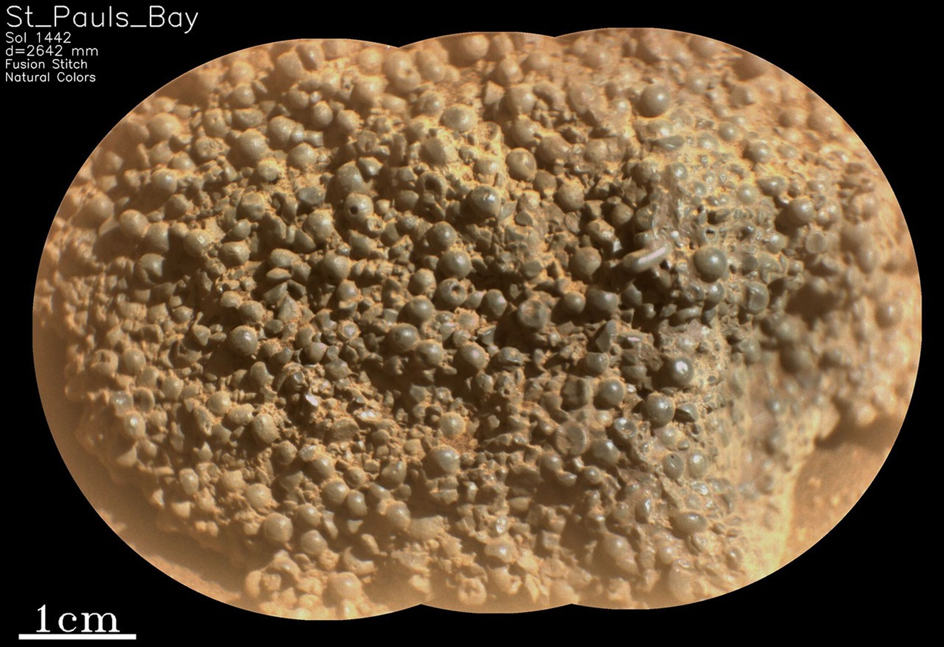
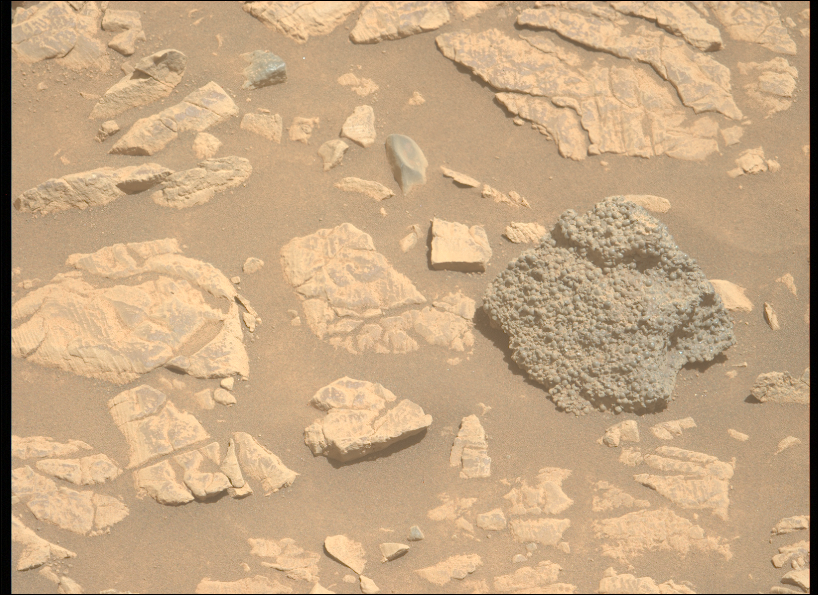
This image from NASA’s Mars Perseverance rover, a fusion-processed SuperCam Remote Micro Imager (RMI) mosaic, shows part of the “St. Pauls Bay” target, acquired from the lower Witch Hazel Hill area of the Jezero crater rim. The image reveals hundreds of strange, spherical-shaped objects comprising the rock. Perseverance acquired this image on March 11, 2025, or sol 1442 — Martian day 1,442 of the Mars 2020 mission.NASA/JPL-Caltech/LANL/CNES/IRAP.It has now been two weeks since Perseverance arrived at Broom Point, situated at the lower slopes of the Witch Hazel Hill area, on the Jezero crater rim. Here, a series of light- and dark- toned bands were visible from orbit, and just last week the rover successfully abraded and sampled one of the light-toned beds. It was from this sampling workspace where Perseverance spied a very strange texture in a nearby rock…
The rock, named “St. Pauls Bay” by the team, appeared to be comprised of hundreds of millimeter-sized, dark gray spheres. Some of these occurred as more elongate, elliptical shapes, while others possessed angular edges, perhaps representing broken spherule fragments. Some spheres even possessed tiny pinholes! What quirk of geology could produce these strange shapes?
This isn’t the first time strange spheres have been spotted on Mars. In 2004, the Mars Exploration Rover Opportunity spotted so-called, “Martian Blueberries” at Meridiani Planum, and since then, the Curiosity rover has observed spherules in the rocks of Yellowknife Bay at Gale crater. Just a few months ago, Perseverance itself also spied popcorn-like textures in sedimentary rocks exposed in the Jezero crater inlet channel, Neretva Vallis. In each of these cases, the spherules were interpreted as concretions, features that formed by interaction with groundwater circulating through pore spaces in the rock. Not all spherules form this way, however. They also form on Earth by rapid cooling of molten rock droplets formed in a volcanic eruption, for instance, or by the condensation of rock vaporized by a meteorite impact.
NASA’s Mars Perseverance rover acquired this image of the “St. Pauls Bay” target (the dark-toned float block in the right of the view) using its Left Mastcam-Z camera, one of a pair of cameras located high on the rover’s remote-sensing mast. Perseverance acquired this image on March 13, 2025 — sol 1444, or Martian day 1,444 of the Mars 2020 mission — at the local mean solar time of 11:57:49.NASA/JPL-Caltech/ASUEach of these formation mechanisms would have vastly different implications for the evolution of these rocks, so the team is working hard to determine their context and origin. St. Pauls Bay, however, was float rock — a term used by geologists to describe something that is not in-place. The team are now working to link the spherule-rich texture observed at St. Pauls Bay to the wider stratigraphy at Witch Hazel Hill, and initial observations have provided tantalizing indications that it could be linked to one of the dark-toned layers identified by the team from orbit. Placing these features in geologic context will be critical for understanding their origin, and determining their significance for the geological history of the Jezero crater rim and beyond!
Share Details Last Updated Mar 23, 2025 Related Terms Explore More 3 min read Sols 4486-4487: Ankle-Breaking Kind of Terrain! Article 1 day ago 4 min read Sols 4484-4485: Remote Sensing on a Monday Article 2 days ago 2 min read Sols 4481-4483: Humber Pie Article 4 days ago Keep Exploring Discover More Topics From NASA MarsMars is the fourth planet from the Sun, and the seventh largest. It’s the only planet we know of inhabited…
All Mars ResourcesExplore this collection of Mars images, videos, resources, PDFs, and toolkits. Discover valuable content designed to inform, educate, and inspire,…
Rover BasicsEach robotic explorer sent to the Red Planet has its own unique capabilities driven by science. Many attributes of a…
Mars Exploration: Science GoalsThe key to understanding the past, present or future potential for life on Mars can be found in NASA’s four…
Shocking Spherules!
- Perseverance Home
- Science
- News and Features
- Multimedia
- Mars Missions
- Mars Home
3 min read
Shocking Spherules!Written by Alex Jones, Ph.D. candidate at Imperial College London
Last week the Perseverance Science Team were astonished by a strange rock comprised of hundreds of millimeter-sized spheres… and the team are now working hard to understand their origin.
This image from NASA’s Mars Perseverance rover, a fusion-processed SuperCam Remote Micro Imager (RMI) mosaic, shows part of the “St. Pauls Bay” target, acquired from the lower Witch Hazel Hill area of the Jezero crater rim. The image reveals hundreds of strange, spherical-shaped objects comprising the rock. Perseverance acquired this image on March 11, 2025, or sol 1442 — Martian day 1,442 of the Mars 2020 mission.NASA/JPL-Caltech/LANL/CNES/IRAP.It has now been two weeks since Perseverance arrived at Broom Point, situated at the lower slopes of the Witch Hazel Hill area, on the Jezero crater rim. Here, a series of light- and dark- toned bands were visible from orbit, and just last week the rover successfully abraded and sampled one of the light-toned beds. It was from this sampling workspace where Perseverance spied a very strange texture in a nearby rock…
The rock, named “St. Pauls Bay” by the team, appeared to be comprised of hundreds of millimeter-sized, dark gray spheres. Some of these occurred as more elongate, elliptical shapes, while others possessed angular edges, perhaps representing broken spherule fragments. Some spheres even possessed tiny pinholes! What quirk of geology could produce these strange shapes?
This isn’t the first time strange spheres have been spotted on Mars. In 2004, the Mars Exploration Rover Opportunity spotted so-called, “Martian Blueberries” at Meridiani Planum, and since then, the Curiosity rover has observed spherules in the rocks of Yellowknife Bay at Gale crater. Just a few months ago, Perseverance itself also spied popcorn-like textures in sedimentary rocks exposed in the Jezero crater inlet channel, Neretva Vallis. In each of these cases, the spherules were interpreted as concretions, features that formed by interaction with groundwater circulating through pore spaces in the rock. Not all spherules form this way, however. They also form on Earth by rapid cooling of molten rock droplets formed in a volcanic eruption, for instance, or by the condensation of rock vaporized by a meteorite impact.
NASA’s Mars Perseverance rover acquired this image of the “St. Pauls Bay” target (the dark-toned float block in the right of the view) using its Left Mastcam-Z camera, one of a pair of cameras located high on the rover’s remote-sensing mast. Perseverance acquired this image on March 13, 2025 — sol 1444, or Martian day 1,444 of the Mars 2020 mission — at the local mean solar time of 11:57:49.NASA/JPL-Caltech/ASUEach of these formation mechanisms would have vastly different implications for the evolution of these rocks, so the team is working hard to determine their context and origin. St. Pauls Bay, however, was float rock — a term used by geologists to describe something that is not in-place. The team are now working to link the spherule-rich texture observed at St. Pauls Bay to the wider stratigraphy at Witch Hazel Hill, and initial observations have provided tantalizing indications that it could be linked to one of the dark-toned layers identified by the team from orbit. Placing these features in geologic context will be critical for understanding their origin, and determining their significance for the geological history of the Jezero crater rim and beyond!
Share Details Last Updated Mar 23, 2025 Related Terms Explore More 3 min read Sols 4486-4487: Ankle-Breaking Kind of Terrain! Article 1 day ago 4 min read Sols 4484-4485: Remote Sensing on a Monday Article 2 days ago 2 min read Sols 4481-4483: Humber Pie Article 4 days ago Keep Exploring Discover More Topics From NASA MarsMars is the fourth planet from the Sun, and the seventh largest. It’s the only planet we know of inhabited…
All Mars ResourcesExplore this collection of Mars images, videos, resources, PDFs, and toolkits. Discover valuable content designed to inform, educate, and inspire,…
Rover BasicsEach robotic explorer sent to the Red Planet has its own unique capabilities driven by science. Many attributes of a…
Mars Exploration: Science GoalsThe key to understanding the past, present or future potential for life on Mars can be found in NASA’s four…
How Warp Drives Actually (Might) Work
To make a warp drive you have to arrange spacetime so that you never locally travel faster than light but still arrive at your destination…faster than light. And in 1994 Mexican physicist Miguel Alcubierre figured out how.
CAS Discovery and Foresight
4 min read
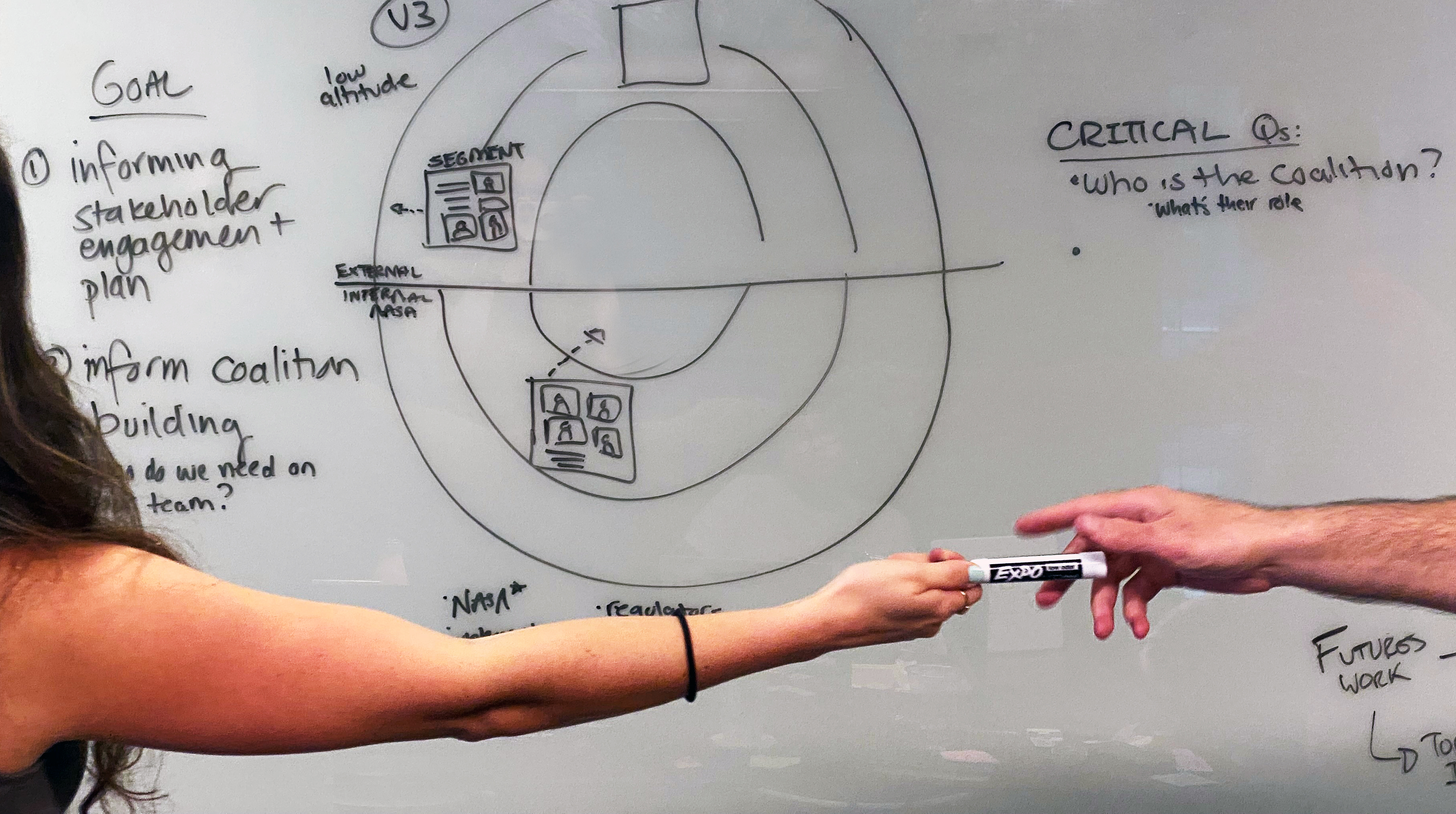
Preparations for Next Moonwalk Simulations Underway (and Underwater) A NASA researcher and innovation architect from the Convergent Aeronautics Solutions project Discovery team collaborating at a whiteboard during a visit to Chapel Hill, N.C. on Aug. 13, 2024.NASA / Ariella KnightConvergent Aeronautics Solutions (CAS) Discovery identifies problems worth solving for the benefit of all.
We formulate “convergent” problems—across multiple disciplines and sectors—and build footholds toward potentially transformative opportunities in aeronautics. As aeronautics rapidly advances, it is increasingly intersecting with other sectors like energy, healthcare, emergency response, economic resilience, the space economy, and more.
CAS Discovery builds new innovation tools and methods, a workforce adept at innovation methods, and transdisciplinary teams of researchers within and beyond NASA that conduct regular “Discovery sprints”—expeditions into cross-sector topic areas that could beneficially transform aeronautics and humanity.
WHAT is Discovery? ParticipatoryIt is difficult to understand and effectively address stakeholders’ needs & capabilities without engaging them. Discovery, in consultation with key NASA offices and other government agencies, has honed mechanisms to lawfully and respectfully engage and invite participation from stakeholders, communities, industry, NGOs and government to collaboratively formulate complex societal challenges tied to aviation.
ConvergentTypical organizational structures limit convergence across knowledge boundaries. CAS Discovery is intentionally cross-sector and transdisciplinary because the most impactful ideas often lie at the intersection of boundaries, the borderlands where multiple disciplines and communities come together. We work to emerge multi-sector, system-of-systems challenges that integrate political, economic, social, technological, environmental, legal and ethical trends, needs, and capabilities.
Future-FocusedOrganizations have a tendency of being driven by short-term thinking and relatively short time horizons. CAS Discovery uses strategic foresight methods to examine 20 to 50-year time horizons, systematically ingesting and synthesizing signals and trends from aero and non-aero sources to envision a variety of scenarios to uncover opportunities for the future of aeronautics.
EcosystemicWe study the ecosystems that are part of aeronautics and aerospace. This helps in broadening consideration of impacts while practicing foresight. It enhances our awareness of the environment and gives stakeholders the ability to see ripple effects across technologies, economies, communities, etc. We seek to benefit the wellness of the entire ecosystem while also benefiting the constituents.
A group of NASA researchers and leaders from the Convergent Aeronautics Solutions project Discovery team at the agency’s Glenn Research Center in Cleveland, on April 30, 2024.NASA / Ricaurte Chock WHO is Discovery? NASA ResearchersThey are the engine that propels CAS Discovery. Our cross-center Discovery sprint and foresight teams are composed of researchers from NASA’s Ames Research Center and Armstrong Flight Research Center in California, Glenn Research Center in Cleveland, and Langley Research Center in Virginia.
Researchers from Outside of NASAThey collaborate with us as subject matter experts or Discovery sprint team members to contribute their backgrounds in fields less common within NASA, such as energy, economics, anthropology, and other areas. This collaboration happens through many mechanisms, such as freelancing, crowdsourcing, interviews, webinars, and podcasts.
StakeholdersThey are engaged in various ways and to different degrees, often co-envisioning potential futures, co-formulating problems, and co-designing solutions.
Innovation ArchitectsThey are the glue that holds CAS Discovery together and the anti-glue that keeps our teams from getting stuck. They come from a wide range of experience, each bringing deep expertise in leading transdisciplinary teams and stakeholders through processes and methods from strategic foresight, complex systems design, human-centered design, and more.
CAS Center Integration Leads (CILs)They work with NASA line management at each Aeronautics center to bring NASA researchers and potential new PIs into CAS. CILs also host annual Wicked Wild idea pitch events to bring new problem areas and solution ideas into CAS Discovery and early Execution phases.
- Ames Research Center CIL: Ty Huang
- Armstrong Flight Research Center CIL: Matt Kearns
- Glenn Research Center CIL: Jeffrey Chin
- Langley Research Center CIL: Devin Pugh-Thomas
They oversee Discovery sprint and strategic foresight teams, topics, and processes; new tools and continuous improvement experiments; and the overall health of the CAS innovation front-end pipeline and related strategic outputs.
- Discovery Lead: Eric Reynolds Brubaker, Langley Research Center
- Foresight Lead: Vikram Shyam, Glenn Research Center
COMING SOON: Links to Technical Memorandums and conference papers.
Facebook logo @NASA@NASAaero@NASA_es @NASA@NASAaero@NASA_es Instagram logo @NASA@NASAaero@NASA_es Linkedin logo @NASA Explore More 2 min read NASA Concludes Wind Study Article 2 years ago 3 min read NASA Armstrong Supports Wind Study Article 2 years ago 4 min read NASA Interns Help Identify Aviation Solutions to Health Care Challenges Article 2 years ago Keep Exploring Discover More Topics From NASAConvergent Aeronautics Solutions
Science Missions
Aeronautics STEM
Explore NASA’s History
Share Details Last Updated Mar 21, 2025 EditorJim BankeContactDiana Fitzgeralddiana.r.fitzgerald@nasa.gov Related TermsCAS Discovery and Foresight
4 min read
Preparations for Next Moonwalk Simulations Underway (and Underwater) A NASA researcher and innovation architect from the Convergent Aeronautics Solutions project Discovery team collaborating at a whiteboard during a visit to Chapel Hill, N.C. on Aug. 13, 2024.NASA / Ariella KnightConvergent Aeronautics Solutions (CAS) Discovery identifies problems worth solving for the benefit of all.
We formulate “convergent” problems—across multiple disciplines and sectors—and build footholds toward potentially transformative opportunities in aeronautics. As aeronautics rapidly advances, it is increasingly intersecting with other sectors like energy, healthcare, emergency response, economic resilience, the space economy, and more.
CAS Discovery builds new innovation tools and methods, a workforce adept at innovation methods, and transdisciplinary teams of researchers within and beyond NASA that conduct regular “Discovery sprints”—expeditions into cross-sector topic areas that could beneficially transform aeronautics and humanity.
WHAT is Discovery? ParticipatoryIt is difficult to understand and effectively address stakeholders’ needs & capabilities without engaging them. Discovery, in consultation with key NASA offices and other government agencies, has honed mechanisms to lawfully and respectfully engage and invite participation from stakeholders, communities, industry, NGOs and government to collaboratively formulate complex societal challenges tied to aviation.
ConvergentTypical organizational structures limit convergence across knowledge boundaries. CAS Discovery is intentionally cross-sector and transdisciplinary because the most impactful ideas often lie at the intersection of boundaries, the borderlands where multiple disciplines and communities come together. We work to emerge multi-sector, system-of-systems challenges that integrate political, economic, social, technological, environmental, legal and ethical trends, needs, and capabilities.
Future-FocusedOrganizations have a tendency of being driven by short-term thinking and relatively short time horizons. CAS Discovery uses strategic foresight methods to examine 20 to 50-year time horizons, systematically ingesting and synthesizing signals and trends from aero and non-aero sources to envision a variety of scenarios to uncover opportunities for the future of aeronautics.
EcosystemicWe study the ecosystems that are part of aeronautics and aerospace. This helps in broadening consideration of impacts while practicing foresight. It enhances our awareness of the environment and gives stakeholders the ability to see ripple effects across technologies, economies, communities, etc. We seek to benefit the wellness of the entire ecosystem while also benefiting the constituents.
A group of NASA researchers and leaders from the Convergent Aeronautics Solutions project Discovery team at the agency’s Glenn Research Center in Cleveland, on April 30, 2024.NASA / Ricaurte Chock WHO is Discovery? NASA ResearchersThey are the engine that propels CAS Discovery. Our cross-center Discovery sprint and foresight teams are composed of researchers from NASA’s Ames Research Center and Armstrong Flight Research Center in California, Glenn Research Center in Cleveland, and Langley Research Center in Virginia.
Researchers from Outside of NASAThey collaborate with us as subject matter experts or Discovery sprint team members to contribute their backgrounds in fields less common within NASA, such as energy, economics, anthropology, and other areas. This collaboration happens through many mechanisms, such as freelancing, crowdsourcing, interviews, webinars, and podcasts.
StakeholdersThey are engaged in various ways and to different degrees, often co-envisioning potential futures, co-formulating problems, and co-designing solutions.
Innovation ArchitectsThey are the glue that holds CAS Discovery together and the anti-glue that keeps our teams from getting stuck. They come from a wide range of experience, each bringing deep expertise in leading transdisciplinary teams and stakeholders through processes and methods from strategic foresight, complex systems design, human-centered design, and more.
CAS Center Integration Leads (CILs)They work with NASA line management at each Aeronautics center to bring NASA researchers and potential new PIs into CAS. CILs also host annual Wicked Wild idea pitch events to bring new problem areas and solution ideas into CAS Discovery and early Execution phases.
- Ames Research Center CIL: Ty Huang
- Armstrong Flight Research Center CIL: Matt Kearns
- Glenn Research Center CIL: Jeffrey Chin
- Langley Research Center CIL: Devin Pugh-Thomas
They oversee Discovery sprint and strategic foresight teams, topics, and processes; new tools and continuous improvement experiments; and the overall health of the CAS innovation front-end pipeline and related strategic outputs.
- Discovery Lead: Eric Reynolds Brubaker, Langley Research Center
- Foresight Lead: Vikram Shyam, Glenn Research Center
COMING SOON: Links to Technical Memorandums and conference papers.
Facebook logo @NASA@NASAaero@NASA_es @NASA@NASAaero@NASA_es Instagram logo @NASA@NASAaero@NASA_es Linkedin logo @NASA Explore More 2 min read NASA Concludes Wind Study Article 2 years ago 3 min read NASA Armstrong Supports Wind Study Article 2 years ago 4 min read NASA Interns Help Identify Aviation Solutions to Health Care Challenges Article 2 years ago Keep Exploring Discover More Topics From NASAConvergent Aeronautics Solutions
Science Missions
Aeronautics STEM
Explore NASA’s History
Share Details Last Updated Mar 21, 2025 EditorJim BankeContactDiana Fitzgeralddiana.r.fitzgerald@nasa.gov Related TermsIs Netflix's 'The Electric State' a sci-fi retelling of 'The Wizard of Oz'?
China now has a 'kill mesh' in orbit, Space Force vice chief says
How the James Webb Space Telescope is helping size up tiny dwarf planets
Stunning Antarctic Sea Creatures Discovered after Iceberg Breaks Away
A calving iceberg exposed a region that never before had been seen by human eyes, revealing a vibrant, thriving ecosystem
