
Feed aggregator
Enceladus Plumes May Hold a Clear Clue to Ocean Habitability
How can scientists estimate the pH level of Enceladus’ subsurface ocean without landing on its surface? This is what a recently submitted study hopes to address as a team of scientists from Japan investigated new methods for sampling the plumes of Enceladus and provide more accurate measurements of its pH levels. This study has the potential to help scientists better understand the subsurface ocean conditions on Enceladus and whether it’s suitable for life as we know it.
Bubble feeding trick spreads through humpback whale social groups
Bubble feeding trick spreads through humpback whale social groups
Cross-training may be the key to a long life
Cross-training may be the key to a long life
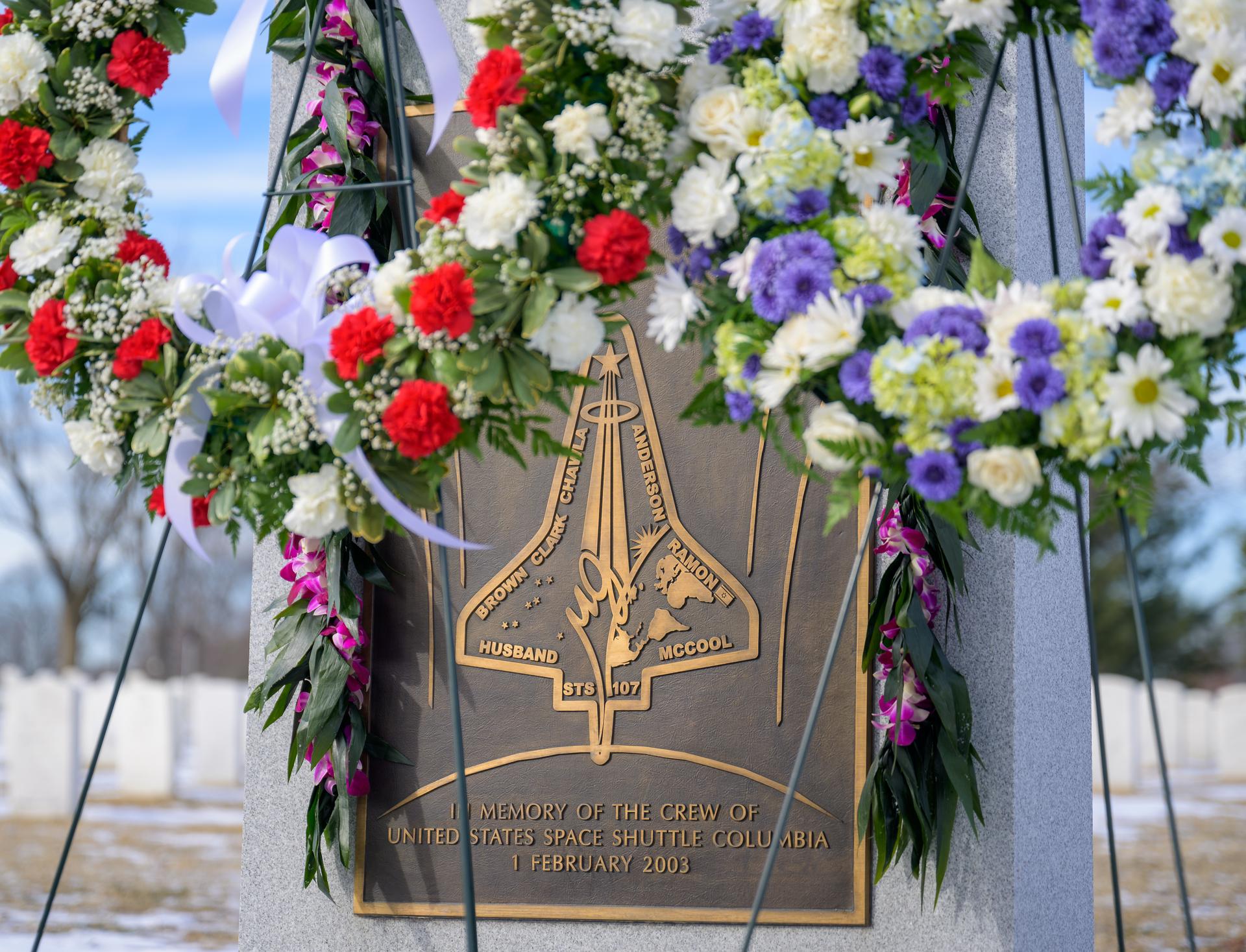
NASA’s Day of Remembrance Honors Fallen Heroes of Exploration
NASA will observe its annual Day of Remembrance on Thursday, Jan. 22, which includes commemorating the crews of Apollo 1 and the space shuttles Challenger and Columbia. The event is traditionally held every year on the fourth Thursday of January, as all three astronaut accidents happened around the end of the month.
“On NASA’s Day of Remembrance, we pause to honor the members of the NASA family who lost their lives while pushing the boundaries of exploration and discovery,” said NASA Administrator Jared Isaacman. “We remember them not to retreat from risk, but to respect it — to learn, to improve, and continue onward. Their sacrifice and the strength of their families will forever inspire us as we continue to reach for the stars and pursue the secrets of the universe.”
Isaacman will lead an observance at 1 p.m. EST at Arlington National Cemetery in Virginia, which will begin with a wreath-laying ceremony at the Tomb of the Unknown Soldier, followed by observances for the Apollo 1, Challenger, and Columbia crews.
Several agency centers also will hold observances:
Johnson Space Center in Houston
NASA Johnson will hold a commemoration at 10 a.m. CST at the Astronaut Memorial Grove with remarks by Center Director Vanessa Wyche, NASA astronaut Jasmin Moghbeli, and Cheryl McNair, widow of Challenger astronaut Ronald McNair. The event will have a moment of silence, a NASA T-38 flyover, taps performed by the Texas A&M Squadron 17, and a procession placing flowers at Apollo I, Challenger, and Columbia memorial trees.
Kennedy Space Center in Florida
NASA Kennedy and the Astronauts Memorial Foundation will host a ceremony at the Space Shuttle Atlantis building at Kennedy’s Visitor Complex at 11 a.m. EST. The event will include musical guests, a bell ringing commemoration, a moment of silence, and wreath-laying. Kelvin Manning, deputy director at NASA Kennedy, and Bob Cabana, former NASA associate administrator and Kennedy center director, will provide remarks during the ceremony, which will livestream on the center’s Facebook page.
Ames Research Center in California’s Silicon Valley
NASA Ames will hold a remembrance ceremony at 1 p.m. PST that includes remarks from Center Director Eugene Tu, a moment of silence, and bell ringing commemoration for each astronaut lost in service.
Langley Research Center in Hampton, Virginia
NASA Langley will hold a remembrance ceremony at 1 p.m. EST with acting Center Director Trina Dyal, followed by placing flags at the Langley Workers Memorial.
Marshall Space Flight Center in Huntsville, Alabama
NASA Marshall will hold a candle-lighting ceremony and wreath placement at 9:30 a.m. CST and include remarks from Rae Ann Meyer, Marshall’s acting center director, and Bill Hill, director of Safety and Mission Assurance at Marshall.
Stennis Space Flight Center in Bay St. Louis, Mississippi
NASA Stennis and the NASA Shared Services Center will hold a wreath-laying ceremony and moment of silence at 10:30 a.m. CST with remarks from Center Director John Bailey and Anita Harrell, NASA Shared Services Center executive director.
The agency also is paying tribute to its fallen astronauts with special online content, updated on NASA’s Day of Remembrance, at:
-end-
Bethany Stevens / Elizabeth Shaw
Headquarters, Washington
202-358-1600
bethany.c.stevens@nasa.gov / elizabeth.a.shaw@nasa.gov
Studying Massive And Mysterious Young Protostars With The Hubble
Newly developing stars shrouded in thick dust get their first baby pictures in these images from NASA’s Hubble Space Telescope. Hubble took these infant star snapshots in an effort to learn how massive stars form. Protostars are shrouded in thick dust that blocks light, but Hubble can detect the near-infrared emission that shines through holes carved in the gas by the young stars themselves.
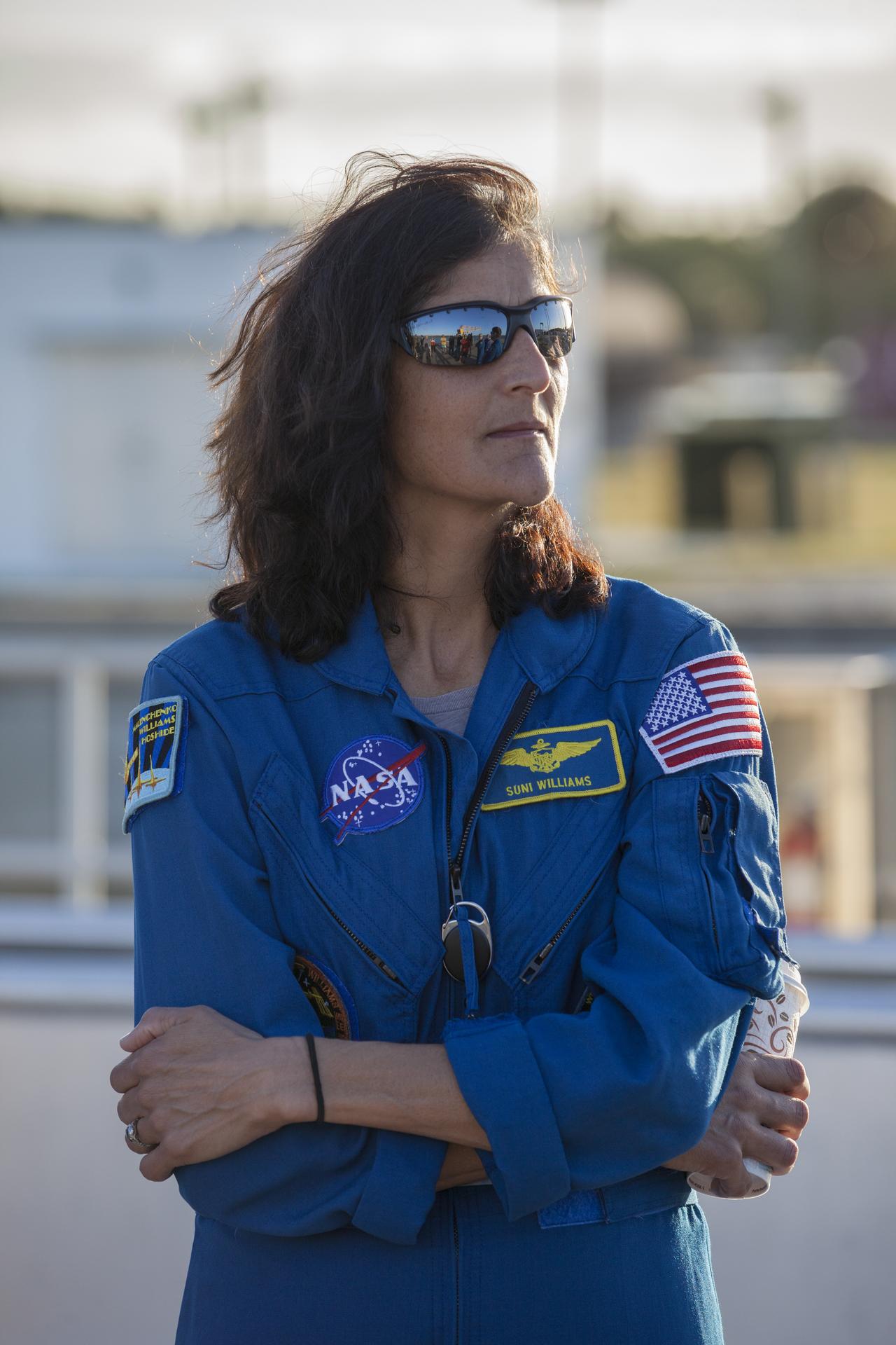
NASA Astronaut Suni Williams Retires
After 27 years of service, NASA astronaut Suni Williams retired from the agency, effective Dec. 27, 2025. Williams completed three missions aboard the International Space Station, setting numerous human spaceflight records throughout her career.
“Suni Williams has been a trailblazer in human spaceflight, shaping the future of exploration through her leadership aboard the space station and paving the way for commercial missions to low Earth orbit,” said NASA Administrator Jared Isaacman. “Her work advancing science and technology has laid the foundation for Artemis missions to the Moon and advancing toward Mars, and her extraordinary achievements will continue to inspire generations to dream big and push the boundaries of what’s possible. Congratulations on your well-deserved retirement, and thank you for your service to NASA and our nation.”
Williams logged 608 days in space — second on the list of cumulative time in space by a NASA astronaut. She ranks sixth on the list of longest single spaceflight by an American, tied with NASA astronaut Butch Wilmore, both logging 286 days during NASA’s Boeing Starliner and SpaceX Crew-9 missions. Williams also completed nine spacewalks, totaling 62 hours and 6 minutes, ranking as the most spacewalk time by a woman and fourth-most on the all-time cumulative spacewalk duration list. She also was the first person to run a marathon in space.
“Over the course of Suni’s impressive career trajectory, she has been a pioneering leader,” said Vanessa Wyche, director of NASA’s Johnson Space Center in Houston. “From her indelible contributions and achievements to the space station, to her groundbreaking test flight role during the Boeing Starliner mission, her exceptional dedication to the mission will inspire the future generations of explorers.”
Williams launched for the first time aboard space shuttle Discovery with STS-116 in December 2006 and returned aboard space shuttle Atlantis with the STS-117 crew. She served as a flight engineer for Expeditions 14/15 and completed a then-record-breaking four spacewalks during the mission.
In 2012, Williams launched from the Baikonur Cosmodrome in Kazakhstan for a 127-day mission as a member of Expedition 32/33. She also served as space station commander for Expedition 33. Williams performed three spacewalks during the mission to repair a leak on a station radiator and replace a component that gets power from the station’s solar arrays to its systems.
Most recently, Williams and Wilmore launched aboard the Starliner spacecraft in June 2024 as part of NASA’s Boeing Crew Flight Test mission. She and Wilmore went on to join Expedition 71/72, and Williams again took command of the space station for Expedition 72. She completed two spacewalks on the mission and returned to Earth in March 2025, as part of the agency’s SpaceX Crew-9 mission.
“Suni is incredibly sharp, and an all-around great friend and colleague,” said Scott Tingle, chief of the Astronaut Office at NASA Johnson. “She’s inspired so many people, including myself and other astronauts in the corps. We’re all going to miss her greatly and wish her nothing but the best.”
Beyond her spaceflight experience, Williams held numerous roles throughout her NASA career. In 2002, she served as a NEEMO (NASA Extreme Environments Mission Operations) crew member, spending nine days living and working in an underwater habitat. After her first flight, she served as deputy chief of NASA’s Astronaut Office. She later was the director of Operations in Star City, Russia, following her second mission to the space station. Most recently, she helped establish a helicopter training platform to prepare astronauts for future Moon landings.
The Needham, Massachusetts, native holds a bachelor’s degree in physical science from the United States Naval Academy and a master’s degree in engineering management from Florida Institute of Technology in Melbourne, Florida. A retired U.S. Navy captain, Williams is an accomplished helicopter and fixed-wing pilot, having logged more than 4,000 flight hours in 40 different aircraft.
“Anyone who knows me knows that space is my absolute favorite place to be,” said Williams. “It’s been an incredible honor to have served in the Astronaut Office and have had the opportunity to fly in space three times. I had an amazing 27-year career at NASA, and that is mainly because of all the wonderful love and support I’ve received from my colleagues. The International Space Station, the people, the engineering, and the science are truly awe-inspiring and have made the next steps of exploration to the Moon and Mars possible. I hope the foundation we set has made these bold steps a little easier. I am super excited for NASA and its partner agencies as we take these next steps, and I can’t wait to watch the agency make history.”
Learn more about how NASA explores the unknown and innovates for the benefit of humanity at:
-end-
Bethany Stevens / Jimi Russell
Headquarters, Washington
202-358-1100
bethany.c.stevens@nasa.gov / james.j.russell@nasa.gov
New NASA Artemis Payloads To Study Moon’s Terrain, Radiation, History
NASA announced Tuesday the selection of three new science investigations that will strengthen humanity’s understanding and exploration of the Moon. As part of the agency’s CLPS (Commercial Lunar Payload Services) initiative and Artemis campaign, American companies will deliver these research payloads to the lunar surface no earlier than 2028.
“With CLPS, NASA has been taking a new approach to lunar science, relying on U.S. industry innovation to travel to the surface of the Moon and enable scientific discovery,” said Joel Kearns, deputy associate administrator for exploration, Science Mission Directorate, NASA Headquarters in Washington. “These selections continue this pipeline of lunar exploration, through research that will not only expand our knowledge about the Moon’s history and environment, but also inform future human safety and navigation on the Moon and beyond.”
The selected scientific payloads are:
- Emission Imager for Lunar Infrared Analysis in 3D (EMILIA-3D). The EMILIA-3D payload will create three-dimensional thermal models of the lunar terrain, using a thermal imager to measure the temperature of the landscape coupled with a stereo pair of visible-light cameras. These models will help the U.S. better image and navigate the Moon’s surface through improved understanding of the properties of the dusty lunar soil, called regolith, and what temperature measurements convey about the lunar surface. The principal investigator is Andrew Ryan at the University of Arizona.
- Lunar Instrumentation for Subsurface Thermal Exploration with Rapidity (LISTER). The LISTER instrument will measure the heat flow of the Moon’s interior by drilling beneath the lunar surface, pausing at intervals to measure temperature changes and the ability of the subsurface material to conduct heat. A previous version of LISTER flew on the Blue Ghost Mission 1 CLPS delivery to the Moon’s near side, where it took eight temperature and thermal conductivity measurements and drilled down to about three feet beneath the lunar surface. This new LISTER investigation will study the heat flow generated by the Moon itself, giving us a better understanding of its thermal history. The principal investigator is Seiichi Nagihara at Texas Tech University.
- Site-agnostic Energetic Lunar Ion and Neutron Environment (SELINE). The SELINE payload will provide new insight into the Moon’s radiation environment by studying, for the first time at the lunar surface, the radiation from both primary galactic cosmic rays and their secondary particles and how this radiation interacts with the lunar regolith. Data from SELINE will improve our understanding of the planetary processes at work on the Moon, as well as inform space weather preparation and safety for long-term human exploration of the lunar surface. The principal investigator is Drew Turner at Johns Hopkins University.
These science experiments, selected through NASA’s Payloads and Research Investigations on the Surface of the Moon call for proposals, do not require a specific landing site on the lunar surface to gather their data, and NASA will assign them to specific CLPS delivery task orders at a later time.
NASA uses CLPS to send scientific instruments and technology demonstrations to advance capabilities for science, exploration, or commercial development of the Moon and beyond. By supporting a steady cadence of lunar deliveries, the agency will continue to enable a growing lunar economy while leveraging the entrepreneurial innovation of the commercial space industry.
To learn more about CLPS and Artemis, visit:
-end-
Alise Fisher
Headquarters, Washington
202-358-2546
alise.m.fisher@nasa.gov
NASA’s Budget Woes Are Over, For Now
Congress has rejected a draconian budget request, passing a bill that funds the space agency similarly to 2025.
The post NASA’s Budget Woes Are Over, For Now appeared first on Sky & Telescope.
NIH Supplements, Facts First Challenge
NASA’s Center of Excellence for Collaborative Innovation (CoECI) assists in the use of crowdsourcing across the federal government. CoECI’s NASA Tournament Lab offers the contract capability to run external crowdsourced challenges on behalf of NASA and other agencies.
The Office of Dietary Supplements (ODS) at the National Institutes of Health (NIH) announces the “Supplements, Facts First: A Digital Adventure for Every Age” challenge. This competition aims to catalyze innovative multimedia strategies to transform static dietary supplement fact sheets into engaging digital experiences. It addresses a critical gap between authoritative supplement information and meaningful public engagement by incentivizing teams to develop prototypes that target the following modalities:
- Behavior Change and Health Information Apps
- Social Media Content
- AI-Enabled Tools
- Serialized Video & Broadcast Content
- Other Technology
Award: $869,000 in total prizes
Open Date: January 20, 2026
Close Date: April 6, 2026
For more information, visit: https://www.herox.com/SupplementsFactsFirst/
NASA Chase Aircraft Ensures X-59’s Safety in Flight
5 min read
Preparations for Next Moonwalk Simulations Underway (and Underwater) NASA’s X-59 quiet supersonic research aircraft flies above Palmdale and Edwards, California, during its first flight Oct. 28, 2025, accompanied by a NASA F/A-18 research aircraft serving as chase.NASA/Jim Ross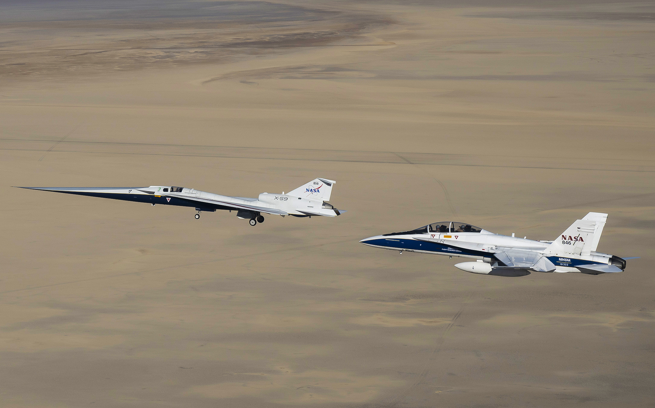
As NASA’s X-59 quiet supersonic research aircraft continues a series of flight tests over the California high desert in 2026, its pilot will be flying with a buddy closely looking out for his safety.
That colleague will be another test pilot in a separate chase aircraft. His job as chase pilot: keep a careful watch on things as he tracks the X-59 through the sky, providing an extra set of eyes to help ensure the flight tests are as safe as possible.
Having a chase pilot watch to make sure operations are going smoothly is an essential task when an experimental aircraft is exercising its capabilities for the first time. The chase pilot also takes on tasks like monitoring local weather and supplementing communications between the X-59 and air traffic control.
“All this helps reduce the test pilot’s workload so he can concentrate on the actual test mission,” said Jim “Clue” Less, a NASA research pilot since 2010 and 21-year veteran U.S. Air Force flyer.
Less served as chase pilot in a NASA F/A-18 research jet when NASA test pilot Nils Larson made the X-59’s first flight on Oct. 28. Going forward, Less and Larson will take turns flying as X-59 test pilot or chase pilot.
NASA pilots Jim “Clue” Less (left) and Nils Larson celebrate the X-59’s first flight on Oct. 28, 2025. Less flew an F-18 chase aircraft while Larson flew the X-59.NASA/Genaro Vavuris Staying Close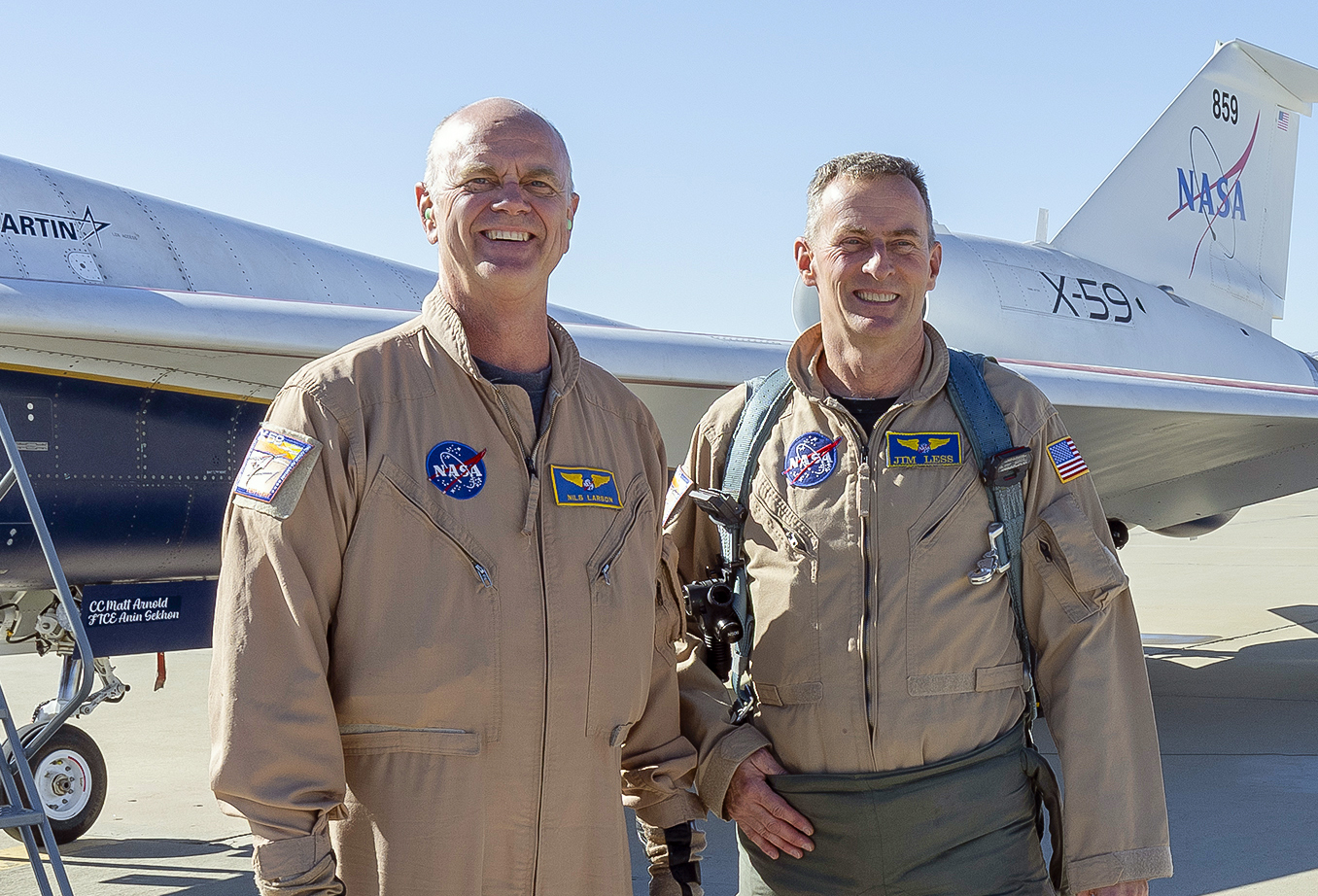
So how close does a chase aircraft fly to the X-59?
“We fly as close as we need to,” Less said. “But no closer than we need to.”
The distance depends on where the chase aircraft needs to be to best ensure the success of the test flight. Chase pilots, however, never get so close as to jeopardize safety.
We fly as close as we need to, but no closer than we need to.Jim "clue" LESS
NASA Test Pilot
For example, during the X-59’s first flight the chase aircraft moved to within a wingspan of the experimental aircraft. At that proximity, the airspeed and altitude indicators inside both aircraft could be compared, allowing the X-59 team to calibrate their instruments.
Generally, the chase aircraft will remain about 500 and 1,000 feet away—or about 5-10 times the length of the X-59 itself—as the two aircraft cruise together.
“Of course, the chase pilot can move in closer if I need to look over something on the aircraft,” Less said. “We would come in as close as needed, but for the most part the goal is to stay out of the way.”
Airborne Photo Op In a view captured from a NASA F/A-18 chase aircraft, the X-59 quiet supersonic research aircraft lifts off for its first flight Oct. 28, 2025, from U.S. Air Force Plant 42 in Palmdale, California.NASA/Lori LoseyThe up-close-and-personal vantage point of the chase aircraft also affords the opportunity to capture photos and video of the test aircraft.
For the initial X-59 flight, a NASA photographer—fully trained and certified to fly in a high-performance jet—sat in the chase aircraft’s rear seat to record images and transmit high-definition video down to the ground.
“We really have the best views,” Less said. “The top focus of the test team always is a safe flight and landing. But if we get some great shots in the process, it’s an added bonus.”
Chase aircraft can also carry sensors that gather data during the flight that would be impossible to obtain from the ground. In a future phase of X-59 flights, the chase aircraft will carry a probe to measure the X-59’s supersonic shock waves and help validate that the airplane is producing a quieter sonic “thump,” rather than a loud sonic boom to people on the ground.
The instrumentation was successfully tested using a pair of NASA F-15 research jets earlier this year.
As part of NASA’s Quesst mission, the data could help open the way for commercial faster-than-sound air travel over land.
Choice of Chase Aircraft A NASA F-15 aircraft sits 20 feet off the left side of the X-59 aircraft, with a white hangar and hills in the background, during electromagnetic interference testing.NASA/Carla Thomas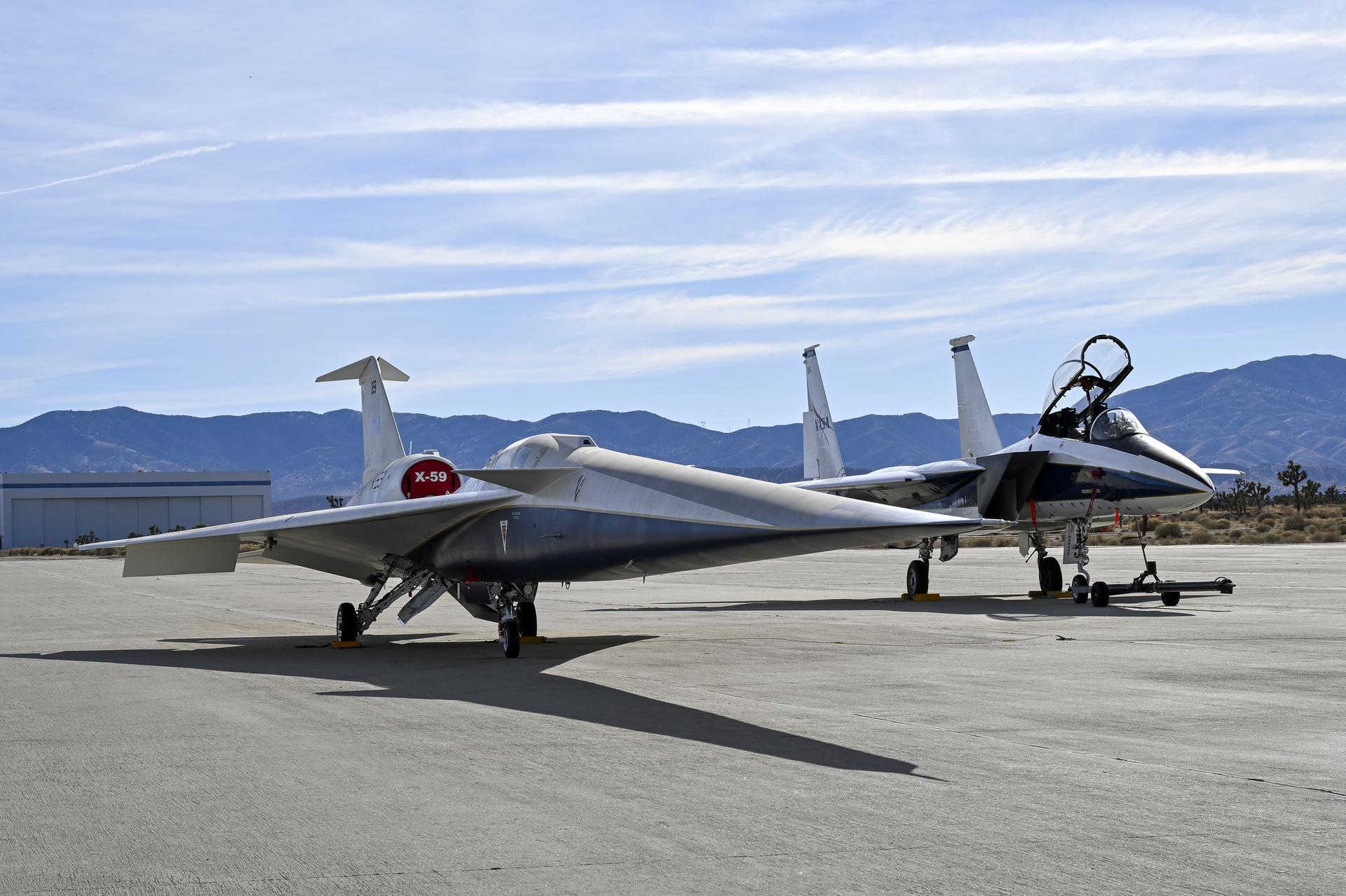
Chase aircraft have served as a staple of civilian and military flight tests for decades, with NASA and its predecessor—the National Advisory Committee for Aeronautics—employing aircraft of all types for the job.
Today, at NASA’s Armstrong Flight Research Center in Edwards, California, two different types of research aircraft are available to serve as chase for X-59 flights: NASA-operated F/A-18 Hornets and F-15 Eagles.
While both types are qualified as chase aircraft for the X-59, each has characteristics that make them appropriate for certain tasks.
The F/A-18 is a little more agile flying at lower speeds. One of NASA’s F/A-18s has a two-seat cockpit, and the optical quality and field of view of its canopy makes it the preferred aircraft for Armstrong’s in-flight photographers.
At the same time, the F-15 is more capable of keeping pace with the X-59 during supersonic test flights and carries the instrumentation that will measure the X-59’s shock waves.
“The choice for which chase aircraft we will use for any given X-59 test flight could go either way depending on other mission needs and if any scheduled maintenance requires the airplane to be grounded for a while,” Less said.
About the AuthorJim BankeManaging Editor/Senior WriterJim Banke is a veteran aviation and aerospace communicator with more than 40 years of experience as a writer, producer, consultant, and project manager based at Cape Canaveral, Florida. He is part of NASA Aeronautics' Strategic Communications Team and is Managing Editor for the Aeronautics topic on the NASA website.
Facebook logo @NASA@NASAaero@NASA_es @NASA@NASAaero@NASA_es Instagram logo @NASA@NASAaero@NASA_es Linkedin logo @NASA Explore More 3 min read NASA Develops Blockchain Technology to Enhance Air Travel Safety and SecurityThrough a drone flight test at NASA’s Ames Research Center, researchers tested a blockchain-based system…
Article 5 days ago 12 min read NASA Armstrong Advances Flight Research and Innovation in 2025 Article 1 month ago 5 min read NASA, Boeing Test How to Improve Performance of Longer, Narrower Aircraft Wings Article 1 month ago Keep Exploring Discover More Topics From NASAMissions
Artemis
Aeronautics STEM
Explore NASA’s History
Share Details Last Updated Jan 20, 2026 EditorJim BankeContactKristen Hatfieldkristen.m.hatfield@nasa.gov Related TermsNASA Chase Aircraft Ensures X-59’s Safety in Flight
5 min read
Preparations for Next Moonwalk Simulations Underway (and Underwater) NASA’s X-59 quiet supersonic research aircraft flies above Palmdale and Edwards, California, during its first flight Oct. 28, 2025, accompanied by a NASA F/A-18 research aircraft serving as chase.NASA/Jim RossAs NASA’s X-59 quiet supersonic research aircraft continues a series of flight tests over the California high desert in 2026, its pilot will be flying with a buddy closely looking out for his safety.
That colleague will be another test pilot in a separate chase aircraft. His job as chase pilot: keep a careful watch on things as he tracks the X-59 through the sky, providing an extra set of eyes to help ensure the flight tests are as safe as possible.
Having a chase pilot watch to make sure operations are going smoothly is an essential task when an experimental aircraft is exercising its capabilities for the first time. The chase pilot also takes on tasks like monitoring local weather and supplementing communications between the X-59 and air traffic control.
“All this helps reduce the test pilot’s workload so he can concentrate on the actual test mission,” said Jim “Clue” Less, a NASA research pilot since 2010 and 21-year veteran U.S. Air Force flyer.
Less served as chase pilot in a NASA F/A-18 research jet when NASA test pilot Nils Larson made the X-59’s first flight on Oct. 28. Going forward, Less and Larson will take turns flying as X-59 test pilot or chase pilot.
NASA pilots Jim “Clue” Less (left) and Nils Larson celebrate the X-59’s first flight on Oct. 28, 2025. Less flew an F-18 chase aircraft while Larson flew the X-59.NASA/Genaro Vavuris Staying CloseSo how close does a chase aircraft fly to the X-59?
“We fly as close as we need to,” Less said. “But no closer than we need to.”
The distance depends on where the chase aircraft needs to be to best ensure the success of the test flight. Chase pilots, however, never get so close as to jeopardize safety.
We fly as close as we need to, but no closer than we need to.Jim "clue" LESS
NASA Test Pilot
For example, during the X-59’s first flight the chase aircraft moved to within a wingspan of the experimental aircraft. At that proximity, the airspeed and altitude indicators inside both aircraft could be compared, allowing the X-59 team to calibrate their instruments.
Generally, the chase aircraft will remain about 500 and 1,000 feet away—or about 5-10 times the length of the X-59 itself—as the two aircraft cruise together.
“Of course, the chase pilot can move in closer if I need to look over something on the aircraft,” Less said. “We would come in as close as needed, but for the most part the goal is to stay out of the way.”
Airborne Photo Op In a view captured from a NASA F/A-18 chase aircraft, the X-59 quiet supersonic research aircraft lifts off for its first flight Oct. 28, 2025, from U.S. Air Force Plant 42 in Palmdale, California.NASA/Lori LoseyThe up-close-and-personal vantage point of the chase aircraft also affords the opportunity to capture photos and video of the test aircraft.
For the initial X-59 flight, a NASA photographer—fully trained and certified to fly in a high-performance jet—sat in the chase aircraft’s rear seat to record images and transmit high-definition video down to the ground.
“We really have the best views,” Less said. “The top focus of the test team always is a safe flight and landing. But if we get some great shots in the process, it’s an added bonus.”
Chase aircraft can also carry sensors that gather data during the flight that would be impossible to obtain from the ground. In a future phase of X-59 flights, the chase aircraft will carry a probe to measure the X-59’s supersonic shock waves and help validate that the airplane is producing a quieter sonic “thump,” rather than a loud sonic boom to people on the ground.
The instrumentation was successfully tested using a pair of NASA F-15 research jets earlier this year.
As part of NASA’s Quesst mission, the data could help open the way for commercial faster-than-sound air travel over land.
Choice of Chase Aircraft A NASA F-15 aircraft sits 20 feet off the left side of the X-59 aircraft, with a white hangar and hills in the background, during electromagnetic interference testing.NASA/Carla ThomasChase aircraft have served as a staple of civilian and military flight tests for decades, with NASA and its predecessor—the National Advisory Committee for Aeronautics—employing aircraft of all types for the job.
Today, at NASA’s Armstrong Flight Research Center in Edwards, California, two different types of research aircraft are available to serve as chase for X-59 flights: NASA-operated F/A-18 Hornets and F-15 Eagles.
While both types are qualified as chase aircraft for the X-59, each has characteristics that make them appropriate for certain tasks.
The F/A-18 is a little more agile flying at lower speeds. One of NASA’s F/A-18s has a two-seat cockpit, and the optical quality and field of view of its canopy makes it the preferred aircraft for Armstrong’s in-flight photographers.
At the same time, the F-15 is more capable of keeping pace with the X-59 during supersonic test flights and carries the instrumentation that will measure the X-59’s shock waves.
“The choice for which chase aircraft we will use for any given X-59 test flight could go either way depending on other mission needs and if any scheduled maintenance requires the airplane to be grounded for a while,” Less said.
About the AuthorJim BankeManaging Editor/Senior WriterJim Banke is a veteran aviation and aerospace communicator with more than 40 years of experience as a writer, producer, consultant, and project manager based at Cape Canaveral, Florida. He is part of NASA Aeronautics' Strategic Communications Team and is Managing Editor for the Aeronautics topic on the NASA website.
Facebook logo @NASA@NASAaero@NASA_es @NASA@NASAaero@NASA_es Instagram logo @NASA@NASAaero@NASA_es Linkedin logo @NASA Explore More 3 min read NASA Develops Blockchain Technology to Enhance Air Travel Safety and SecurityThrough a drone flight test at NASA’s Ames Research Center, researchers tested a blockchain-based system…
Article 5 days ago 12 min read NASA Armstrong Advances Flight Research and Innovation in 2025 Article 1 month ago 5 min read NASA, Boeing Test How to Improve Performance of Longer, Narrower Aircraft Wings Article 1 month ago Keep Exploring Discover More Topics From NASAMissions
Artemis
Aeronautics STEM
Explore NASA’s History
Share Details Last Updated Jan 20, 2026 EditorJim BankeContactKristen Hatfieldkristen.m.hatfield@nasa.gov Related TermsWhat Created This Strange Iron Bar In The Ring Nebula?
The Ring Nebula is a well-studied planetary nebula about 2,570 light-years away. Nnew observations of the nebula with a new instrument have revealed a previously unseen component. The William Herschel Telescope used its WEAVE instrument to detect a massive 'iron bar' inside the nebula's inner layer.