
NASA - Breaking News
NASA Armstrong Contributions Propel Artemis, Deep Space Innovation
5 min read
Preparations for Next Moonwalk Simulations Underway (and Underwater)NASA is leveraging expertise, capabilities, and partnerships across its centers to make Artemis campaign and deep space exploration safer, more reliable, and efficient. At NASA’s Armstrong Flight Research Center in Edwards, California, contributions include technical leadership, unique flight-testing capabilities, and management of a key technology program that advances critical exploration concepts.
Artemis II is an upcoming challenging test flight, and the lessons learned will directly prepare NASA to return humans to the surface of the Moon on Artemis III and beyond, as well as send the first astronauts – Americans – to Mars.
Gulfstream G-III aircraft collects heat shield data A NASA Gulfstream G-III aircraft lifts off from NASA’s Armstrong Flight Research Center in Edwards, California, on Tuesday, Jan. 20, 2026. Modifications were made to the aircraft to enable it to join three others flying at different altitudes to capture a complete view of the Orion spacecraft’s heat shield during Artemis II reentry. This effort is part of NASA’s Scientifically Calibrated In-Flight Imagery project.NASA/Carla ThomasAs preparations continue for the Artemis II launch, NASA Armstrong technicians modified a Gulfstream G-III to collect heat shield data during Orion’s reentry. As part of NASA’s Scientifically Calibrated In-Flight Imagery, the G-III will join other aircraft to capture Orion’s thermal protection data.
“Before the Artemis II mission begins, the aircraft will complete a dress rehearsal over the Pacific Ocean to verify the airborne system performance,” said Robert Navarro, NASA Armstrong support aircraft fleet project manager.
Technicians at NASA’s Johnson Space Center in Houston installed sensors and special windows for the imagery mission with assistance from NASA Armstrong technicians.
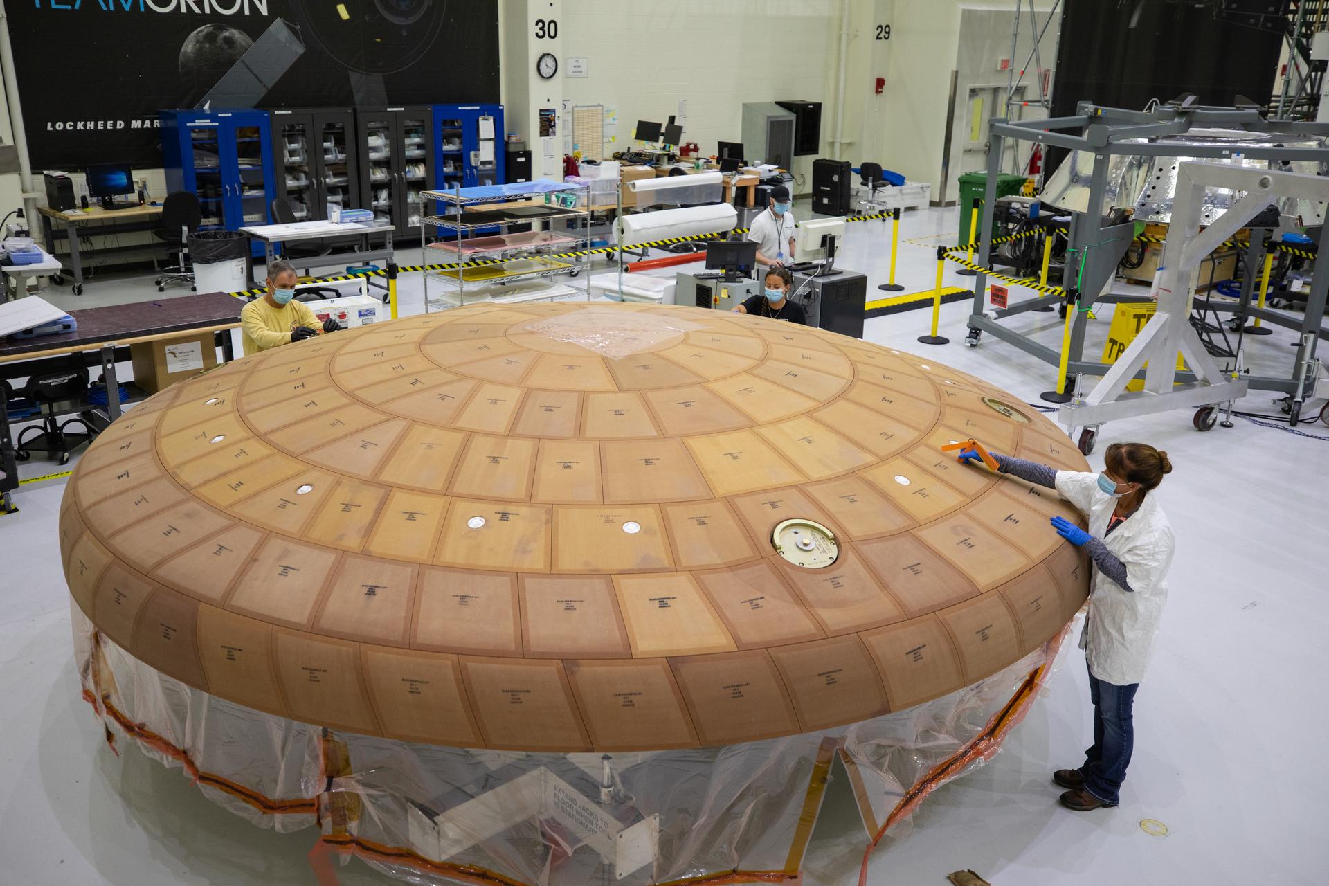
Measuring Orion’s reentry heat Inside the Neil Armstrong Operations and Checkout Building high bay at NASA’s Kennedy Space Center in Florida, from left, technicians Kenny Leidner, Diamond ScharSenstine, Russ Novak and Darlene Beville with ASRC Federal, inspect AVOCAT block bonding on the Artemis II heat shield on July 2, 2020. The heat shield is one of the most critical elements of Orion and will protect the capsule and astronauts during reentry through Earth’s atmosphere. Artemis II is the first crewed mission in a series of missions to the Moon and on to Mars. Artemis II will confirm all of the Orion spacecraft’s systems operate as designed in the actual environment of deep space with astronauts aboard. NASA/Isaac WatsonNASA Armstrong also assists with the Orion heat shield spectrometer system for Artemis II. The system is designed to collect shock layer radiation data from the heat shield during atmospheric entry, data that will be used to enhance astronaut safety.
NASA Armstrong’s expertise in integrating technologies, high reliability flight test instrumentation, and flight operations are a match for some Artemis and deep space projects.
“There is nothing that can go to space or come back without going through the atmosphere, so our mission of atmospheric flight research and test is very relevant,” said Brad Flick, NASA Armstrong center director. “We specialize in testing technologies and working through the challenges of flight.”
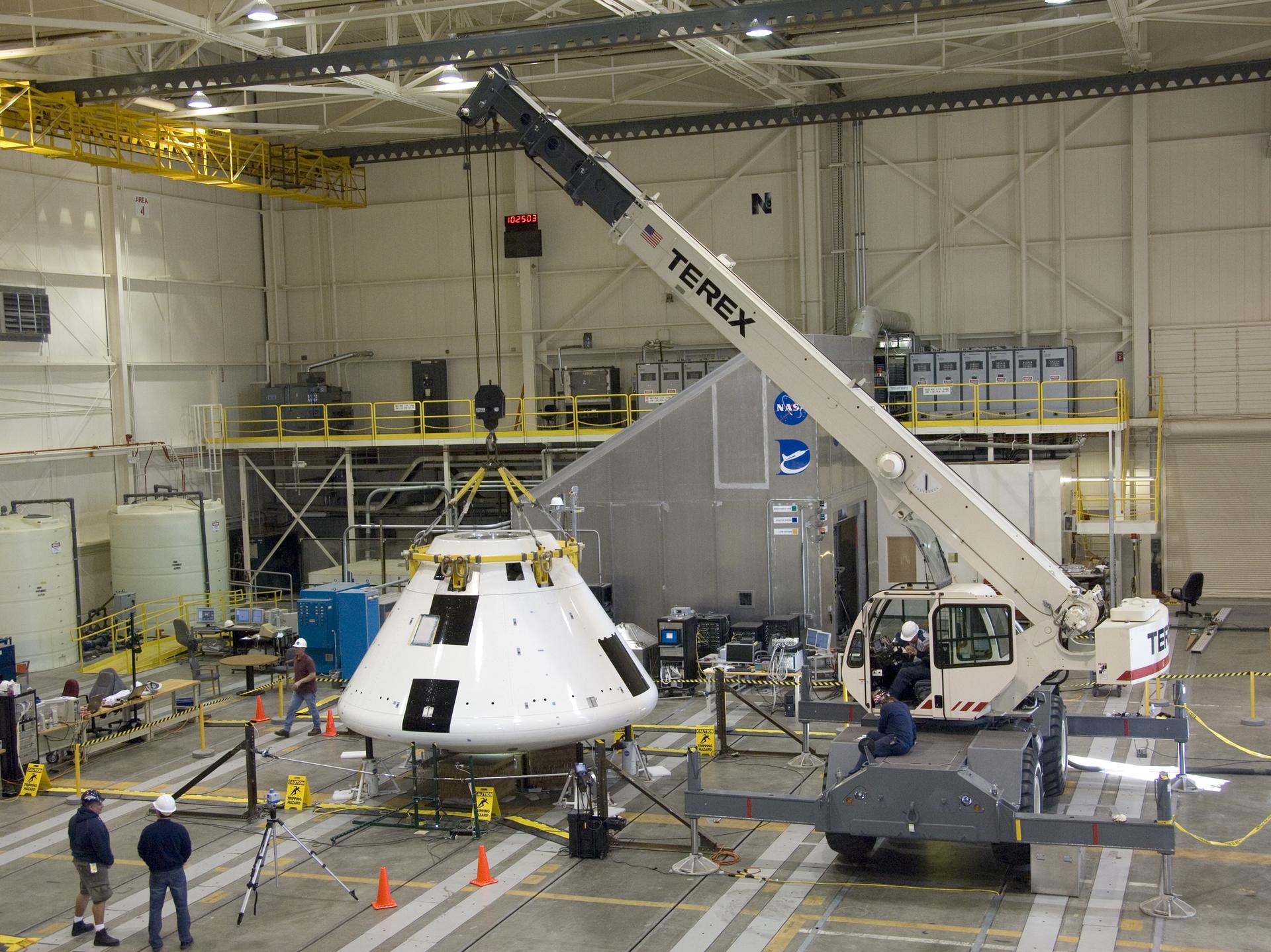
Testing Orion’s launch abort system Under the watchful eyes of technicians, a crane positions the Orion Pad Abort-1 Abort Flight Test module for mass properties testing in the Flight Loads Laboratory at NASA’s Armstrong Flight Research Center in Edwards, California.NASA/Tony Landis Teamwork was on full display at NASA’s Armstrong Flight Research Center in Edwards, California, on Aug. 13, 2009, as engineers and technicians prepared the Pad Abort-1 vehicle – the Orion launch abort system development test article. After assembly and integration, the mock crew capsule was transported to the U.S. Army’s White Sands Missile Range in New Mexico where it successfully completed its test on May 6, 2010.NASA/Tony LandisNASA Armstrong demonstrated that approach when it tested a system to enable Artemis astronauts to escape harm in the event of an emergency on the ground, or in the boost phase of the Orion spacecraft.
“We proved the system could get the astronauts to safety,” said Cathy Bahm, project manager for NASA’s Low Boom Flight Demonstrator. Earlier in her career, she played key roles in engineering, integration, and management for Pad Abort-1 and Ascent Abort-2 that validated the Orion spacecraft’s launch abort system.
Armstrong integrated and tested the capsule and abort system and operations at the launch abort pad at White Sands Test Facility in New Mexico for the Pad Abort-1 test.
“Hopefully we’ll never need it, but knowing I contributed to the safety of future astronauts is a highlight of my career,” Bahm said. “Looking back on it, it was a tremendous accomplishment for the center, the team, and a contribution to the future of space travel.”
Flight Opportunities program advances space tech A NASA F/A-18 research aircraft flies near NASA’s Armstrong Flight Research Center in Edwards, California, on Feb. 24, 2025, testing a commercial precision landing technology for future space missions. The Psionic Space Navigation Doppler Lidar (PSNDL) system is installed in a pod located under the right wing of the aircraft.NASAAnother contributor to future space travel is the Flight Opportunities program, which matures capabilities needed for NASA missions and commercial applications while strategically investing in the growth of the U.S. commercial spaceflight industry. NASA Armstrong manages the program, which supports flight testing of promising technologies, instruments, and experiments aboard commercial vehicles. Part of the agency’s Space Technology Mission Directorate, the program identifies the best ideas – from industry, academia, and NASA researchers – for flight testing.
Flight Opportunities advanced precision landing and optical communications technologies for future lunar missions.
“Landing safely in shadowed lunar regions is critical,” said Greg Peters, Flight Opportunities program manager.
Another deep space technology Flight Opportunities supported was a vibration isolation platform that helped provide extremely precise pointing for the Deep Space Optical Communications technology demonstration. That instrument used lasers to transmit data between Earth and the Psyche spacecraft from more than 215 million miles away, which could benefit future missions to Mars.
NASA Armstrong tested Doppler Lidar system navigation on an F/A-18 to prepare for Moon and Mars missions.
Contributions to Artemis, deep space exploration April Torres and Angelo De La Rosa remove wire harnesses for signal input for the Orion Ascent Abort-2 vehicle from electrostatic discharge protective covers at NASA’s Armstrong Flight Research Center in California. NASA/Lauren HughesNASA Armstrong’s work supporting Artemis and future deep space exploration missions also includes:
- A NASA F/A-18 based at NASA Armstrong tested an autopilot for the SLS (Space Launch System) that proved sensors would work at the trajectory needed for landing on Mars.
- NASA Armstrong researchers advanced a Fiber Optic Sensing System that flew in space for the first time on the Low Earth Orbit Flight Test of an Inflatable Decelerator mission.
- NASA Armstrong researchers developed a cryogenic FOSS, called CryoFOSS, to support future deep space missions. CryoFOSS was used during testing of a system designed to liquefy oxygen – as it would on the Moon or Mars – for use as return-trip fuel. By producing fuel on-site, missions could avoid carrying return fuel from Earth, significantly reducing launch weight and overall mission cost.
- NASA Armstrong staff were in the control rooms when the Orion spacecraft launch abort system was demonstrated.
- Before the Ascent Abort-2 tests could advance, NASA Armstrong assisted with component testing and integration work.
- NASA Armstrong photographers and videographers documented the Orion parachute tests in Yuma, Arizona.
Under the Artemis campaign, NASA is returning humans to the Moon for economic benefits, scientific discovery, and to prepare for crewed missions to Mars.
Share Details Last Updated Feb 04, 2026 EditorDede DiniusContactTeresa Whitingteresa.whiting@nasa.govLocationArmstrong Flight Research Center Related Terms Explore More 4 min read Preparing for Artemis II: Training for a Mission Around the Moon Article 6 days ago 3 min read NASA Heat Shield Technology Enables Space Industry Growth Article 7 days ago 3 min read I Am Artemis: Doug Parkinson Article 7 days ago Keep Exploring Discover More Topics From NASAArmstrong Flight Research Center
Aircraft Flown at Armstrong
Artemis
Flight Opportunities
NASA Heat Shield Tech Contributes to America’s Space Industry
This Jan. 29, 2026, photo captures the streak the Varda Space Industries W-5 capsule made while returning to Earth. The capsule uses a protective heat shield Varda produced made of cutting-edge material it licensed from NASA. The material, known as C-PICA (Conformal Phenolic Impregnated Carbon Ablator), provides a stronger, less expensive, and more efficient thermal protection coating to capsules, allowing them – and their valuable contents – to return to Earth safely.
Developed at NASA’s Ames Research Center in California’s Silicon Valley, C-PICA sets the standard for heat shields, reflecting the decades of expertise that NASA brings to designing, developing, and testing innovative thermal protection materials. This flight test of Varda-produced C-PICA was supported by NASA’s Flight Opportunities program.
Image credit: Varda Space Industries/William Godward
NASA’s SPHEREx Examines Comet 3I/ATLAS’s Coma
NASA/JPL-Caltech Photojournal Navigation Downloads NASA’s SPHEREx Examines Comet 3I/ATLAS’s Coma
PNG (1.87 MB)
Description
These observations by NASA’s SPHEREx (Spectro-Photometer for the History of the Universe, Epoch of Reionization and Ices Explorer) show the infrared light emitted by the dust, water, organic molecules, and carbon dioxide contained within comet 3I/ATLAS’s coma. The comet brightened significantly during the December 2025 period when SPHEREx made the observations — about two months after the icy body had passed its closest distance to the Sun in late October.
The space telescope has the singular capability of seeing the sky in 102 colors, each representing a wavelength of infrared light that provides unique information about galaxies, stars, planet-forming regions, or other cosmic features, including the various gases and dust seen in the coma of 3I/ATLAS. The information gathered by SPHEREx helps scientists better understand what materials 3I/ATLAS contains and how the interstellar object’s pristine ices react to the Sun’s heating as the comet journeys through the solar system.
The mission is managed by NASA’s Jet Propulsion Laboratory in Southern California for the agency’s Astrophysics Division within the Science Mission Directorate in Washington. The telescope and the spacecraft bus were built by BAE Systems. The science analysis of the SPHEREx data is being conducted by a team of scientists at 13 institutions across the U.S., and in South Korea and Taiwan, led by Principal Investigator Jamie Bock, based at Caltech with a joint JPL appointment, and by JPL Project Scientist Olivier Dore. Data is processed and archived at IPAC at Caltech in Pasadena, which manages JPL for NASA. The SPHEREx dataset is freely available to scientists and the public.
For more information about the SPHEREx mission visit: https://science.nasa.gov/mission/spherex/
Keep Exploring Discover More Topics From Photojournal
Photojournal
Search Photojournal
Photojournal’s Latest Content
Feedback
Tracking Glacial Change with Landsat and Radar
- Landsat Home
- Missions
- News
- Data
- Benefits
- Outreach
- Multimedia
- About
For the first time, scientists have created a comprehensive global dataset revealing how the world’s glaciers speed up and slow down with the seasons. Published in Science in November 2025, this groundbreaking study analyzed over 36 million satellite image pairs—including decades of Landsat data—to track the seasonal “pulse” of every major glacier on Earth.
The research, built off the ITS_LIVE ice velocity dataset from NASA’s Jet Propulsion Laboratory (JPL), reveals that seasonal glacier dynamics are becoming more pronounced as our planet warms, with the strongest seasonal variations occurring where annual maximum temperatures exceed freezing. Armed with this global perspective, researchers can continue to tease out patterns in glacial dynamics, identifying how factors including geology and hydrology impact seasonal melting.
Alex Gardner, a scientist at NASA JPL and a co-author on this study, explains how combining Landsat and radar data makes this research possible.
What makes this research unique from other studies of glacial dynamics?While many past studies have investigated seasonal changes in glacier flow, they have typically focused on single glaciers or specific regions. This localization makes it difficult to extrapolate findings to the rest of the world.
This study is the first to characterize seasonal flow changes for all the world’s glaciers. By applying a consistent methodology globally, we were able to isolate the universal relationships that drive seasonal fluctuations in glacier flow.
Why did you use Landsat in this work? Did it give you any insight that would have been difficult to get otherwise?We utilized data from Landsat 4/5/7/8/9, as well as ESA’s Sentinel 2 (optical) and Sentinel 1 (radar). Landsat offers an unmatched historical record with dense temporal sampling, particularly following the launch of Landsat 8 in 2013.
Three factors make Landsat imagery ideal for detecting “surface displacements” (the subtle pixel shifts used to estimate flow):
- Near-exact repeat orbits: The satellite returns to the exact same position.
- Nadir viewing: The instrument looks directly downward.
- Stable instrument geometry: Distortion is minimized.
We measure surface displacement using a technique called feature tracking, which tracks the movement of specific surface details between a primary and a secondary image.
This approach works best with high-resolution imagery because there are more “features” to track. Therefore, we utilize the 15m panchromatic band. For the older Landsat 4/5 data, we use Band 2 (visible red) because it provides the best contrast over bright glacier surfaces.
You used Landsat data in combination with radar data to track ice velocity. What did each of these datasets contribute?Optical and Radar imagery are highly complementary and allow us to reconstruct a complete timeline of glacier flow:
- Radar (Active Sensor): Can image the surface day or night, regardless of cloud cover, but struggles with feature tracking when the surface is melting (wet snow/ice).
- Optical (Passive Sensor): Requires sunlight and clear skies, but performs significantly better than radar when the surface is melting.
We characterized uncertainty by analyzing retrieved velocities over stationary surfaces, such as bedrock. If our data showed high variability or movement in areas we know are not moving (like rock), we knew those measurements carried a higher uncertainty.
You found that glacier dynamics vary by region and glacier type. Why is it important to understand these global differences?A glacier’s response to external forces—such as meltwater lubricating the bedrock or changes in frontal melting—is highly dependent on local factors (e.g., the material beneath the glacier or the shape of the fjord). This makes it risky to assume that findings from one glacier apply to another.
Our study identified general patterns by observing nearly every glacier on Earth. A key finding was the relationship between temperature and flow:
Seasonal variability becomes prominent when annual maximum temperatures exceed 0°C.
The amplitude of that seasonal cycle increases with every degree of warming above that threshold.
Are there plans to incorporate Landsat 9 data into future studies? How would improvements in remote sensing technology (increased temporal revisit, spatial resolution, etc.) impact glacial velocity analyses?We are already ingesting Landsat 9 data into the ITS_LIVE project, which is designed to scale quickly with new sensors. Future sensor improvements offer a trade-off:
- Increased Spatial Resolution: Allows us to track a higher number of surface features, improving flow estimates.
- Increased Temporal Frequency: Reduces data gaps caused by surface changes (loss of features), but can potentially increase error rates. This is because displacement is an accumulated signal; features move half the distance in an 8-day pair compared to a 16-day pair, making the movement harder to distinguish from background noise.
This study is just the tip of the iceberg. The dataset is rich with insights on glacier mechanics that are waiting to be uncovered. While we hope to make new discoveries in the coming years, we are equally excited to see what breakthroughs come from the wider scientific community exploring this open data.
An animation shows an ice cap in the Canadian Arctic with monthly ice-velocity measurements overlaid from January through December. Red areas, indicating high ice velocities, expand across the ice cap during the summer months. NASA/Chad GreeneExplore More
Tracking Glacial Change with Landsat and Radar
5 min read
NASA Scientist Alex Gardner highlights how Landsat made his research into the dynamics of glacial flow possible.
Feb 4, 2026 ArticleChilled New York City
3 min read
Ice in the Hudson River hugged the shore of Manhattan amid a deep freeze.
Feb 4, 2026 ArticleCracking Antarctic Sea Ice
4 min read
Icebreakers play a critical role in delivering supplies to America’s largest research base in Antarctica.
Feb 3, 2026 Article1
2
3
…
292
Next
Chilled New York City
- Earth
- Earth Observatory
- Image of the Day
- EO Explorer
- Topics
- More Content
- About
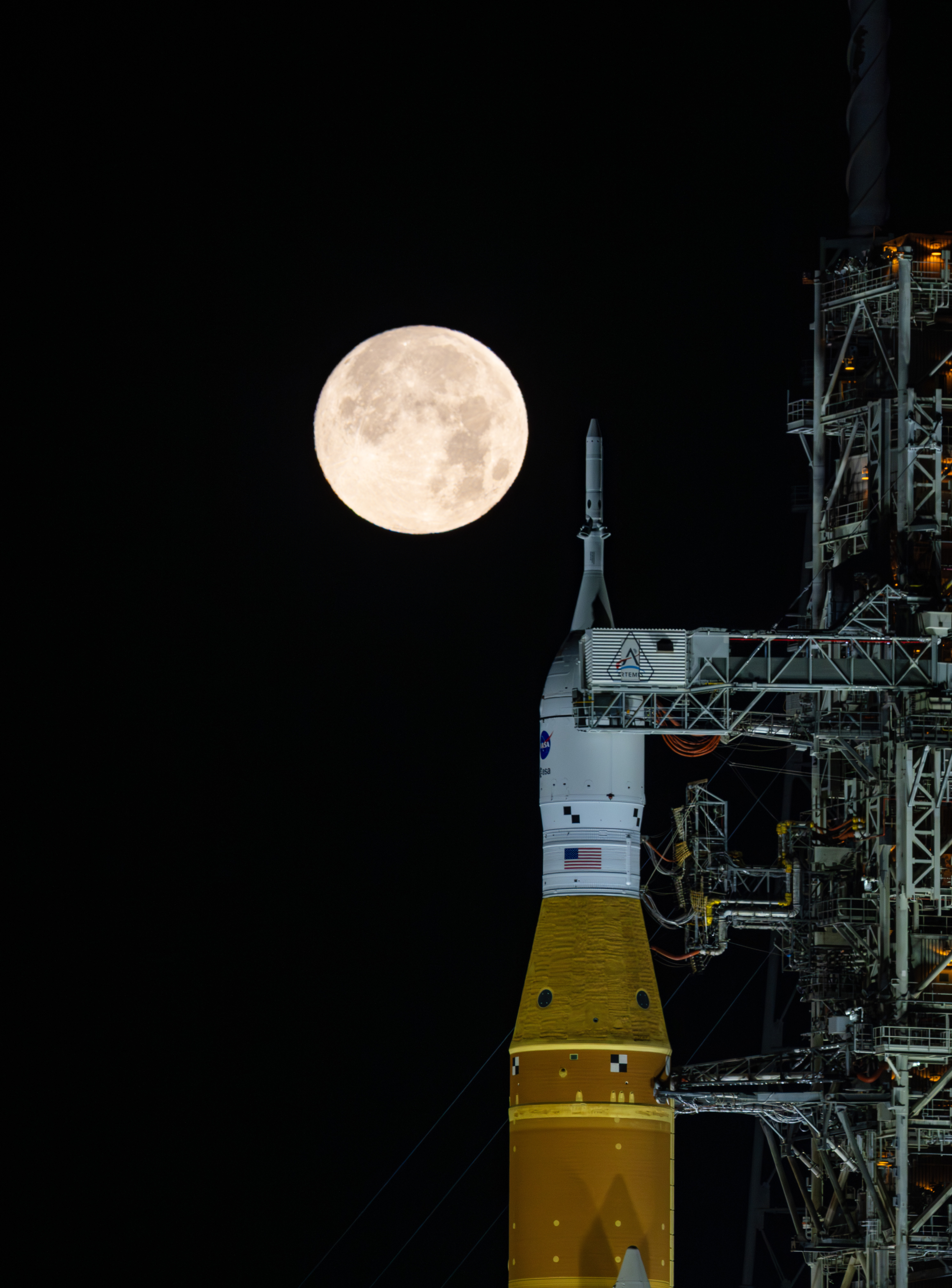
Full Moon over Artemis II
A full moon is seen shining over NASA’s SLS (Space Launch System) and Orion spacecraft, atop the mobile launcher at Launch Pad 39B at NASA’s Kennedy Space Center in Florida in the early hours of February 1, 2026.
The agency concluded a wet dress rehearsal for the agency’s Artemis II test flight early Tuesday morning, successfully loading cryogenic propellant into the SLS (Space Launch System) tanks, sending a team out to the launch pad to closeout Orion, and safely draining the rocket. The wet dress rehearsal was a prelaunch test to fuel the rocket, designed to identify any issues and resolve them before attempting a launch. To allow teams to review data and conduct a second wet dress rehearsal, NASA now will target March as the earliest possible launch opportunity for the flight test.
Read more about the wet dress rehearsal.
Image credit: NASA/Sam Lott
NASA Space to Soil Challenge
Rapid advances in commercial space, artificial intelligence, and edge computing are transforming what is possible for Earth observation. By pushing more intelligence onboard, missions can move from passively collecting data to actively interpreting and responding to changing surface conditions in near-real time, enabling more targeted observations and dramatically improving the value of data returned to the ground. Within this context, land-focused applications such as regenerative agriculture, sustainable forestry, and broader land resilience efforts stand to benefit enormously from satellites that can adapt what, when, and how they sense based on dynamic environmental signals and algorithmic insight rather than fixed schedules or static acquisition plans.
NASA Earth Science Technology Office (ESTO) invites participants to design small satellite (SmallSat) mission concepts that leverage adaptive sensing and onboard processing to enhance regenerative agriculture, forestry, or a similar land resilience objective. Participants must work within onboard power, compute, and bandwidth constraints characteristic of SmallSat missions, focusing on how to orchestrate existing land observation algorithms into an efficient, responsive onboard intelligence layer. Both hardware-oriented and software-oriented solutions—or combinations of the two—are encouraged.
NASA’s primary objective for this challenge is to advance computational and systems approaches for adaptive sensing or onboard processing on SmallSat missions. The goal is not to develop new agricultural or forestry science but rather to improve how SmallSats sense, process, and deliver information to enable these applications.
Award: $400,000 in total prizes
Challenge Open Date: January 30, 2026
Submission Close Date: May 4, 2026
For more information, visit: https://nasa-space-to-soil.org/
Cracking Antarctic Sea Ice
- Earth
- Earth Observatory
- Image of the Day
- EO Explorer
- Topics
- More Content
- About
NASA Astronaut to Answer Questions from Students in Pennsylvania
NASA astronaut Chris Williams will connect with students in Pennsylvania to answer prerecorded science, technology, engineering, and mathematics (STEM) questions while aboard the International Space Station.
The Earth-to-space call will begin at 12:20 p.m. EST Thursday, Feb. 5, and will stream live on the agency’s Learn With NASA YouTube channel.
Media interested in covering the event must RSVP by 5 p.m., Wednesday, Feb. 4, to Tamara Krizek at: 917-692-5038 or tamara.krizek@davincisciencecenter.org.
The Da Vinci Science Center will host this event in Allentown, Pennsylvania, for students in kindergarten through grade 12, and members of the community. This unique opportunity aims to deepen understanding of space exploration and inspire young people to pursue a future career in STEM.
For more than 25 years, astronauts have continuously lived and worked aboard the space station, testing technologies, performing science, and developing skills needed to explore farther from Earth. Astronauts communicate with NASA’s Mission Control Center in Houston 24 hours a day through SCaN’s (Space Communications and Navigation) Near Space Network.
Research and technology investigations taking place aboard the space station benefit people on Earth and lay the groundwork for other agency deep space missions. As part of NASA’s Artemis campaign, the agency will send astronauts to the Moon to prepare for future human exploration of Mars, inspiring the world through discovery in a new Golden Age of innovation and exploration.
See more information on NASA in-flight calls at:
https://www.nasa.gov/stemonstation
-end-
Gerelle Dodson
Headquarters, Washington
202-358-1600
gerelle.q.dodson@nasa.gov
Sandra Jones
Johnson Space Center, Houston
281-483-5111
sandra.p.jones@nasa.gov
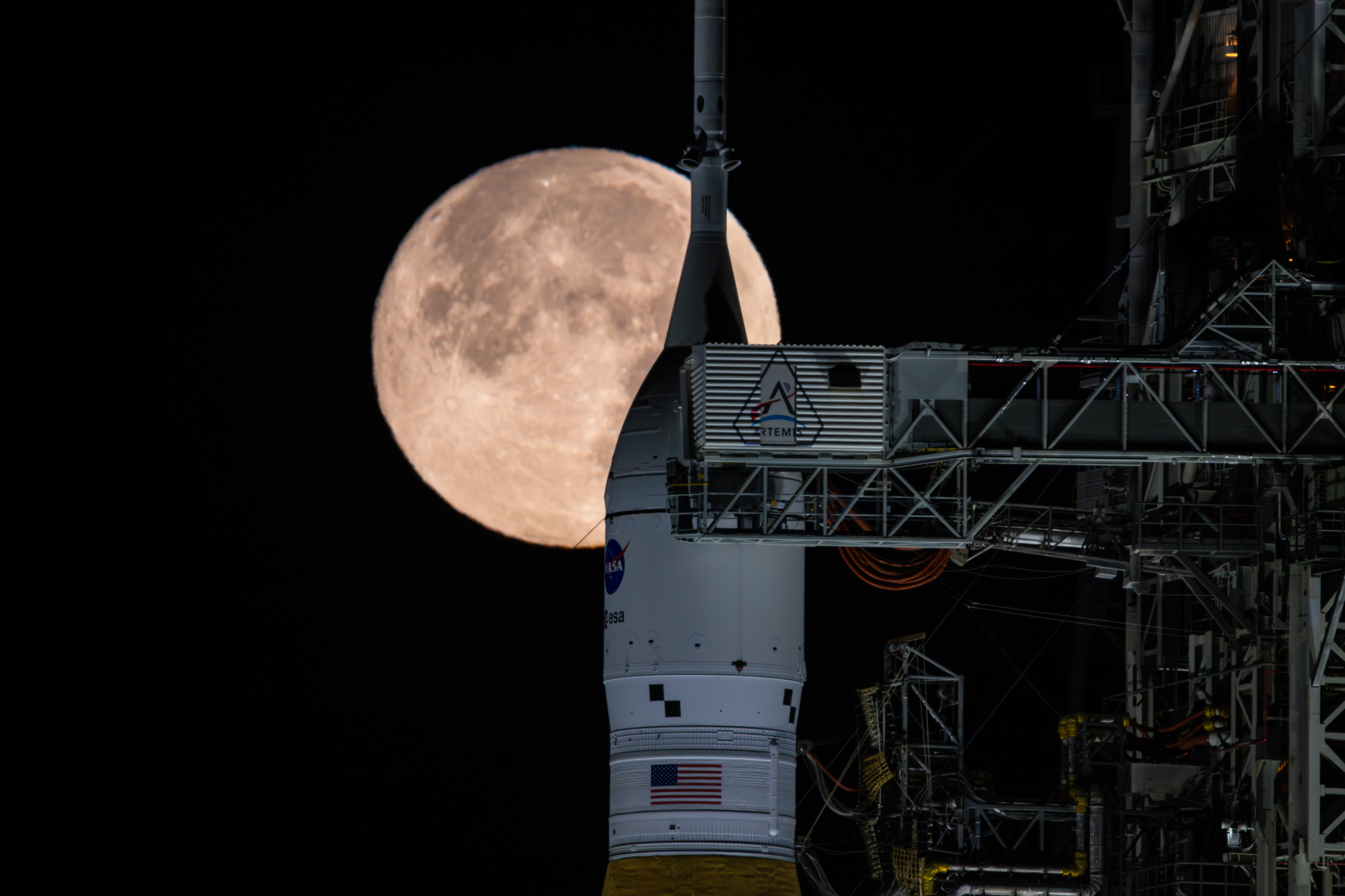
NASA’s Orion Spacecraft at Launch Pad
NASA’s Orion spacecraft, which will carry the Artemis II crew around the Moon, sits at the launch pad on Jan. 17, 2026, after rollout. It rests atop the SLS (Space Launch System) rocket. Orion can provide living space on missions for four astronauts for up to 21 days without docking to another spacecraft. Advances in technology for deep space travel such as life support, avionics, power systems, and state-of-the-art thermal protection will support the crew during launch, landing, and recovery.
Image credit: NASA/Brandon Hancock
NASA to Discuss Early Results of Artemis II Wet Dress Rehearsal
Editor’s note: This advisory was updated at on Feb. 3, 2026, to reflect a change in the start of the news conference and its participants, as well as removing a placeholder for a crew media gaggle.
Following a fueling test of NASA’s SLS (Space Launch System) rocket at the launch pad for the Artemis II Moon mission, leaders will discuss initial results during a news conference at 1 p.m. EST on Tuesday, Feb. 3.
The agency’s SLS rocket and Orion spacecraft arrived at Launch Pad 39B at NASA’s Kennedy Space Center in Florida on Jan. 17. Since then, engineers have been conducting a variety of tests prior to launch. Underway now is a wet dress rehearsal, which requires filling the rocket with the 700,000 gallons of propellant. Call to stations began Jan. 31, and teams are counting down to a simulated launch window opening at 9 p.m. Monday. If more work is needed, NASA may rollback SLS and Orion into the Vehicle Assembly Building after the wet dress rehearsal.
The agency will stream the news conference live on its YouTube channel. A 24/7 live stream of the rocket remains online, as well as a separate feed for coverage of the wet dress rehearsal. Look for individual streams for these events to watch on YouTube. Learn how to stream NASA content through a variety of online platforms, including social media.
Participants in the news conference include:
- NASA Associate Administrator Amit Kshatriya
- Lori Glaze, acting associate administrator for the Exploration Systems Development Mission Directorate
- Shawn Quinn, program manager, Exploration Ground Systems
- John Honeycutt, chair, Artemis II Mission Management Team
Media previously credentialed for launch may join this event in person. To participate in the news conference virtually, media must RSVP no later than two hours prior to the start of the call to Lauren Low in the Office of Communications at: lauren.e.low@nasa.gov. NASA’s media credentialing policy is online.
As part of a Golden Age of innovation and exploration, Artemis will pave the way for new U.S. crewed missions on the lunar surface in preparation to send the first astronauts to Mars.
To learn more about the Artemis campaign, visit:
-end-
Cheryl Warner / Rachel Kraft
Headquarters, Washington
202-358-1600
cheryl.m.warner@nasa.gov / rachel.h.kraft@nasa.gov
Tiffany Fairley
Kennedy Space Center, Florida
321-747-8306
tiffany.l.fairley@nasa.gov
Widely Attended Gatherings (WAGs) Determinations
2026
2026 TSC Artemis II Pre-launch Reception 2.5.26
2026 VABA AAAAM Legislative Reception 2.4.26
Chamber of Commerce Summit 2.2.26
Cheniere Energy at the National Portrait Gallery 1.28.26
Leaders for a Better Louisiana at Adams and Reese 1.28.26
California Manufacturers and Technology Association Reception 1.23.26
Goddard Memorial Dinner 3.13.26
2026 Amentum Artemis II Rollout Reception 1.14.26
Maryland Space Business Roundtable 1.14.26
2025
Commercial Space Federation 12.9.25
Ansys Government Initiatives (AGI) 12.16.25
Maryland Space Business Roundtable (MSBR) 12.10.25
Space Policy Institute 10.21.2025
MSBR Space Business Roundtable 10.15.2025
76th International Astronautical Congress_IAC 9.29.25
2025 Von Braun Memorial Dinner 10.29.25
Space Foundation Reception 9.16.25
Evening with the Stars 9.10.25
Greater Houston Partnership Reception 6.12.25
Space Foundation and German Embassy Reception 6.5.25
H2M Conference and Events 5.28-29.25
American Rocketry Challenge Reception 5.17.25
Rockets on the Hill Reception 5.16.25
Dayton Development Coalition Event 5.13.25
2025 Space Heroes and Legends Gala
Thunderbird School and Global Management Reception
40th Space Symposium Main Events
SPI/GWU/USRA Symposium.3.27.25
Goddard Memorial Dinner.3.21.25
2025 Satellite Exhibition Event.3.10.25 to 3.13.25
67th Laureate Awards Dinner.3.6.25
Bae Systems SPHEREx Launch.2.27.25
2025 Artemis Suppliers Conference
Creole-Queen NOLA Reception.1.13.25
2025 New Glenn Mission 1 Launch Event
2025 Firefly Blue Origin Launch Reception
2024
Aero Club Award Dinner.12.13.24
Space Foundation Event.12.13.24
Commercial Space Federation Joint Event.12.9.24
The Arthur C. Clarke Foundation Event.11.21.24
Planet Labs PBC Reception.11.20.24
Blue Origin and KBR Dinner.10.30.24
36th Annual Dr. Wernher von Braun Memorial Dinner
2024 Keystone Space Conference
WIA Reception and Awards Dinner.10.10.24
2024 JPL Europa Clipper Launch Reception.10.8.24
AIA & Amazon Reception.8.26.24
Farnborough Air Show.7.20-21.24
Artemis II SLS Roll Out Reception.7.15.24
Astroscale Reception Tokyo.7.12.24
Brooke Owens Fellowship Dinner.7.11.24
Greater Cleveland Partnership.6.13-14.24
Coalition for Deep Space Exploration Return to the Moon.6.5.24
The 2024 Infinite Exhibit Grand Opening
AIA and German Embassy Reception.6.4.24
AIA and British Embassy Reception.5.22.24
Space Foundation Event.5.16.24
Foundation Fratelli Tutti Dinners.5.10-11.24
H2M Conference and Event.5.7-8.24
Crowell & Moring Reception.4.16.24
2024 Space Heroes and Legends Awards Dinner
SpaceX Symposium Reception.4.10.24
39th Space Symposium Supplemental
39th Space Symposium Main Events
Goddard Memorial Dinner.3.22.24
AIA and Amazon Reception.3.19.24
Embassy of Australia and Space Foundation.2.29.24
2024 Artemis Suppliers Conference
2024 Aerospace Days Legislative Reception
IDGA 17th Annual Event.1.23 – 24.24
Latino Biden-Harris Appointees Reception.1.11.24
2024 Axiom Space AX-3 Launch Reception
2023
2023 Astrobotic PM1 PreLaunch Reception
AERO Club Awards Dinner.12.15.23
SCL and GBM Foundation Reception.12.11.23
LASP and Ball Aerospace Reception.12.11.23
L Oreal USA for Women Event.11.16.23
KBR Welcome Reception.11.14.23
Museum of Natural History Board Events 11.2.23
2023 Von Braun Memorial Dinner
Planet Labs PBC Reception.10.26.23
WIA Reception and Award Dinner.10.12.23
National Space Club Banquet 2023
Space Foundation and Airbus.10.3.23
2023 VASBA HR AUVSI Gala and Symposium
AIA Congress Space Reception.9.7.23
Space Foundation Reception 7.19.23
Chamber of Commerce Reception.7.13.23
ECI Fellows Meeting.7.12 to 7.14.23
Embassy of Italy and Virgin Galactic.7.12.23
Brook Owens Fellowship Dinner 7.13.23
Comteck and Airbus Space Defense 07.11.23.
2023 Axiom Space AX-2 Launch Event WAG
AIAA Awards Gala Event 5.18.23
38th Space Symposium 4.16 to 4.20.23
Planet Labs PGC Reception.4.13.23
2023 TEMPO Pre-Launch Reception
Coalition for Deep Space Exploration SLS Orion EGS Gateway Suppliers 3.26.23
Orion SLS Conference 3.27 to 3.28.23
2023 Agency WAG Debus Award Banquet
VHMC And Boeing Reception 3.18.23
Ball Aerospace Kinship Reception 3.15.23
SpaceX Satellite Reception 3.13.23
Goddard Memorial Dinner 3.10.23
Space Foundation Event 2.16.23
BDB National Engineers Week 2023 Banquet
MSBR Lunch 2.28.23
STA Luncheon 2.7.23
WSBR Reception 2.1.23
SPI GWU SWF Reception 1.31.23
Artemis I Splashdown 01.17.23
MSBR Lunch 1.17.23
2022
GRC An Evening With the Stars 8.30.22
JPL 25 Years on Mars Reception 7.27.22
SPI GWU Dinner 7.6.22
Berlin Air Show 6.22-26.22
MSBR Lunch 6.21.22
KSC Gateway VIP Rception 6.14.22
MSBR Dinner Gala 6.10.22
NAA Robert J. Collier Awards Dinner 6.9.22
Advanced Space and Rocket Lab Capstone Event 6.8.22
AIA Challenger Center Reception 6.2.22
2022 H2M Summit 5.17-19.22
MSBR Lunch 5.17.22
FCW GovExec Awards Dinner 5.12.22
Meta Reception 5.4.22
JSC RNASA Luncheon and Dinner 4.29.22
Coalition for Deep Space Reception 4.28.22
SLS Orion EGS Suppliers Conference 4.28-29.22
SPI GWU Dinner 4.27.22
AIAA Awards Gala Dinner 4.27.22
MSBR Luncheon 4.19.2022
Arianespace Northrop Grumman JWST Reception 4.5.22
37th Space Symposium 4.4 to 7.22
Axiom Space Launch Event 3.30.22
Heinrich Boell Foundation Dinner 3.30.22
Aarianespace Reception 3.23.22
SIA Conference Events 3.21-23.22 Revised
Satellite Industry Association Reception 3.21.22
Goddard Memorial Dinner 3.18.22
GOES-T Post-Launch Reception 3.1.22
Goes-T L3 Harris Reception 3.1.22
Christopher Newport University Dinner 02.23.22
NG-17 CRS Launch Events VA 2.19.22
SPI GWU Dinner 02.04.2022
MSBR Dinner 01.18.2022
KSC CCTS Spaceport Summit 1.11-12.22
2021
JWST Launch 12.25.21
Aero Club Awards Reception 12.17.21
KSC NSC Celebrate Space 12.10.21
AGI Ansys Reception 12.10.21
KSC Ball Aerospace IXPE Launch Celebration Reception 12.7.21
WIA Awards Dinner 12.2.21
National Space Council Recognition Reception 12.1.21
SPI Dinner 11.16.21
AIAA ASCEND Event 11.15.21
AIAA Ascend 2021 Reception Dinner Las Vegs 11.14.21
KSC Astronaut Hall of Fame Event 11.13.21
KSC DNC Taste of Space Event 11.5.21
SPI Dinner 11.2.21
IAC Closing Gala 10.29.21
GRC Evening With The Stars 10.27.21
Goddard Memorial Awards Dinner 10.22.21
IAC 2021
Lucy Post Launch Dinner 10.16.21
KSC Lucy Launch Mission Events 10.12-13.21
United Airlines Reception 10.12.21
Blue Origin Launch 10.12.21
SPI Dinner on or about 9.28.21
Goddard Memorial Dinner 9.17.21 CANCELLED
SPI Dinner 9.7.21
RNASA Awards Dinner and Luncheon 9.3.21
GRC Evening With the Stars 8.31.21
FED100 Gala Awards Dinner 8.27.21
Addendum to 36th Space Symposium 8.22-26.21
36th Space Symposium 8.22-26.21
KSC ASF Innovators Gala 8.14.21
NG16 Launch Events 8.10.21
LaRC Virginia Space Reception 7.30.21
KSC 2021 Debus Award Dinner 7.30.21
Coalition for Deep Space 07.22.21
KSC Lockheed WAS Star Center Reception 7.15.21
2020
United Launch Alliance Satellite 2020 Reception 3.10.20
SpaceX Reception 3.9.20
U.S. Chamber of Commerce 2020 Aviation Summit 3.5.20
Maryland Space Business Roundtable Lunch 2.18.20
SLS Orion Suppliers Conference 2.12.20
Coalition for Deep Space Exploration Reception 2.11.20
Northrop Grumman NG-13 CRS Launch Events 2.9.20
VA UAS AeroSpace Legislative Reception 1.29.20
MSBR Lunch 1.21.20
Guidance Keough School of Global Affairs 1.16.20
Boeing Orbital Flight Test Launch Events 12.20.19
Virgin Space Reception 12.17.19
SEA Summit 12.17.19
Wright Memorial Dinner 12.13.19
Analytical Graphics AGI Reception 12.13.19
Ball Reception 12.10.19
MSBR Lunch 12.3.19
Plant Reception 11.20.19
JSC Spacecom Conference VIP Reception 11.20.19
JSC Spacecom Conference Reception 11.19.19
SAIC BSU STEM Roundtable 11.07.19
Apollo UK Productions Ltd 7.10.19
SpaceX Satellite Reception 5.6.19
SPI GWU Dinner 5.1.19
AIAA Reception 4.30.19
MSBR Lunch 1.21.20
MSBR Lunch 1.21.20
Seasons Change in Southwest Virginia
- Earth
- Earth Observatory
- Image of the Day
- EO Explorer
- Topics
- More Content
- About
NASA Selects Axiom Space for Fifth Private Mission to Space Station
NASA and Axiom Space have signed an order for the fifth private astronaut mission to the International Space Station, targeted to launch no earlier than January 2027 from the agency’s Kennedy Space Center in Florida.
“The award of our fifth private astronaut mission shows that commercial space is not a distant promise, but a present reality,” said NASA Administrator Jared Isaacman. “By expanding access and sharpening competition in low Earth orbit, these missions are building the capabilities NASA will rely on as we move outward to the Moon, Mars, and beyond. We look forward to building upon those capabilities with many private astronaut missions to come.”
Axiom Mission 5 is expected to spend up to 14 days aboard the space station. A specific launch date will depend on overall spacecraft traffic at the orbital outpost and other planning considerations.
“The International Space Station is a critical platform for enabling commercial industry in low Earth orbit,” said Dana Weigel, manager, International Space Station Program, NASA’s Johnson Space Center in Houston. “Private astronaut missions allow the station to be used as a proving ground for new markets and technologies while enabling science, research, and outreach to contribute to a growing space economy.”
Axiom Space will submit four proposed crew members to NASA and its international partners for review. Once approved and confirmed, they will train with NASA, international partners, and the launch provider for their mission.
“We are honored NASA awarded Axiom Space its fifth human spaceflight mission,” said Jonathan Cirtain, president and CEO, Axiom Space. “All four previous missions have expanded the global community of space explorers, diversifying scientific investigations in microgravity, and providing significant insight that is benefitting the development of our next-generation space station, Axiom Station. The award underscores Axiom Space’s commitment to redefining access to space, fostering international collaboration, and enabling research opportunities in low Earth orbit for the benefit of all.”
Axiom Space will purchase mission services from NASA, including crew consumables, cargo delivery, storage, and other in-orbit resources for daily use. NASA will purchase from Axiom Space the capability to return scientific samples that must be kept cold during transit back to Earth.
NASA made the selection from proposals received in response to its March 2025 NASA Research Announcement. The agency is finalizing the mission order for the sixth private astronaut mission to the space station and will share additional information once available.
Missions aboard the International Space Station, including private astronaut missions, contribute to advancing scientific knowledge and demonstrating new technologies for future human and robotic exploration flights as part of NASA’s Moon and Mars exploration approach, including lunar missions through NASA’s Artemis campaign.
Learn more about NASA’s commercial space strategy at:
https://www.nasa.gov/commercial-space
-end-
Jimi Russell
Headquarters, Washington
202-358-1600
james.j.russell@nasa.gov
Anna Schneider / Joseph Zakrzewski
Johnson Space Center, Houston
281-483-5111
anna.c.schneider@nasa.gov / joseph.a.zakrzewski@nasa.gov
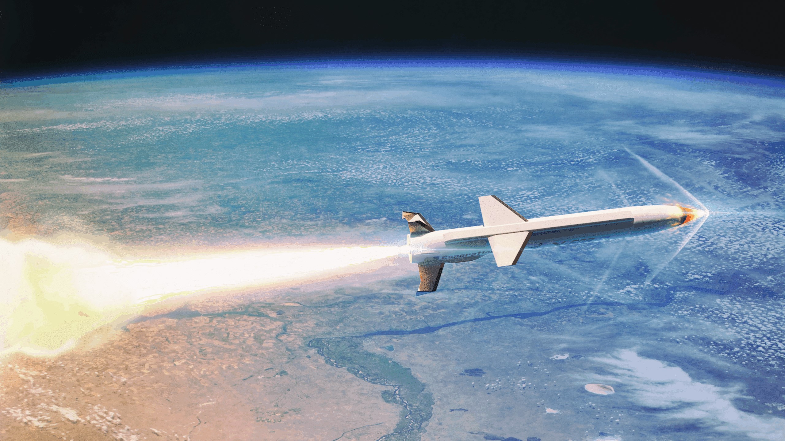
NASA Aims to Advance Hypersonic Flight Testing with New Awards
3 min read
Preparations for Next Moonwalk Simulations Underway (and Underwater) The NASA award to SpaceWorks Enterprises will focus on research using the company’s X-60 platform. SpaceWorksWhile NASA is working with U.S. aviation to explore commercial supersonic technologies, the agency is also looking forward to an even faster era of flight – one of vehicles that can fly hypersonic, or five times the speed of sound. And to further that vision, NASA has issued two awards for studies into vehicle concepts.
Some types of vehicles – such as rockets – achieve hypersonic speeds by carrying supplies of oxygen to allow their fuel to burn, instead of using the surrounding air. In contrast, NASA’s Hypersonic Technology Project works to advance “airbreathing,” reusable hypersonic aircraft, which take in air as they fly, allowing for much longer sustained cruising at hypersonic speeds.
Given commercial interest in finding applications for airbreathing hypersonic vehicles, the Hypersonic Technology Project is looking to find ways to make testing and development easier. Two contract awards the project made in August are aimed at helping to provide an affordable bridge between hypersonic ground and flight tests.
“With these awards, NASA will collaborate with the commercial hypersonics industry to identify new ways to evaluate technologies through flight tests while we address the challenges of reusable, routine, airbreathing, hypersonic flight,” said Dr. Nateri Madavan, director of NASA’s Advanced Air Vehicles Program.
The new awards went to SpaceWorks Enterprises, of Atlanta, Georgia, and Stratolaunch of Mojave, California, both of which will support a six-month NASA study exploring how current vehicles could be modified to meet the need for reusable, high-cadence, affordable flight-testing capabilities. SpaceWorks, which received $500,000, will focus on the X-60 platform. Stratolaunch, which received $1.2 million, will focus on its Talon-A platform.
Through these awards, NASA wants industry to help define the capabilities needed to achieve flight test requirements. The work will also potentially support a future NASA Making Advancements in Commercial Hypersonics (MACH) project focused on advancing commercial hypersonic vehicles through the development of infrastructure such as cost estimates and schedule requirements for a potential flight vehicle.
NASA advances U.S. hypersonic research through the Hypersonic Technology Project under the agency’s Advanced Air Vehicles Program. NASA intends for these projects to help lead the way in enabling revolutionary advancements in fundamental airbreathing hypersonic technologies.
Facebook logo @NASA@NASAaero@NASAes @NASA@NASAaero@NASA_es Instagram logo @NASA@NASAaero@NASA_es Linkedin logo @NASA Explore More 4 min read NASA Science Flights Venture to Improve Severe Winter Weather Warnings Article 1 week ago 4 min read NASA, GE Aerospace Hybrid Engine System Marks Successful Test Article 1 week ago 4 min read NASA Tests Technology Offering Potential Fuel Savings for Commercial Aviation Article 2 weeks ago Keep Exploring Discover More Topics From NASAMissions
Humans In Space
Solar System ExplorationEyes on the Solar System
Explore NASA’s History
Share Details Last Updated Jan 30, 2026 EditorLillian GipsonContactJim Bankejim.banke@nasa.gov Related TermsVisualizing Perseverance’s AI-Planned Drive on Mars
NASA/JPL-Caltech Photojournal Navigation Downloads Visualizing Perseverance’s AI-Planned Drive on Mars
PNG (326.26 KB)
PIA26646 Animation
MP4 (157.38 MB)
Description
This animation of NASA’s Perseverance was created with the Caspian visualization tool using data acquired during an 807-foot (246-meter) drive on the rim of Jezero Crater made by the rover on Dec. 10, 2025, the 1,709th Martian day, or sol, of the mission. The mission’s “drivers,” or rover planners, use the information to understand the Perseverance’s autonomous decision-making process during its drive by showing why it chose one specific path over other options.
This was one of two drives, the first being on Dec. 8, in which generative artificial intelligence provided the route planning. The AI analyzed high-resolution orbital imagery from the HiRISE (High Resolution Imaging Science Experiment) camera aboard NASA’s Mars Reconnaissance Orbiter and terrain-slope data from digital elevation models to identify critical terrain features — bedrock, outcrops, hazardous boulder fields, sand ripples, and the like. From that analysis, it generated a continuous path complete with waypoints, fixed locations where the rover takes up a new set of instructions.
The pale blue lines depict the track the rover’s wheels take. The black lines snaking out in front of the rover depict the different path options the rover is considering moment to moment. The white terrain Perseverance drives onto in the animation is a height map generated using data the rover collected during the drive. The pale blue circle that appears in front of the rover near the end of the animation is a waypoint.
NASA’s Jet Propulsion Laboratory, which is managed for the agency by Caltech, built and manages operations of the Perseverance rover.
For more about Perseverance: science.nasa.gov/mission/mars-2020-perseverance/
Keep Exploring Discover More Topics From Photojournal
Photojournal
Search Photojournal
Photojournal’s Latest Content
Feedback
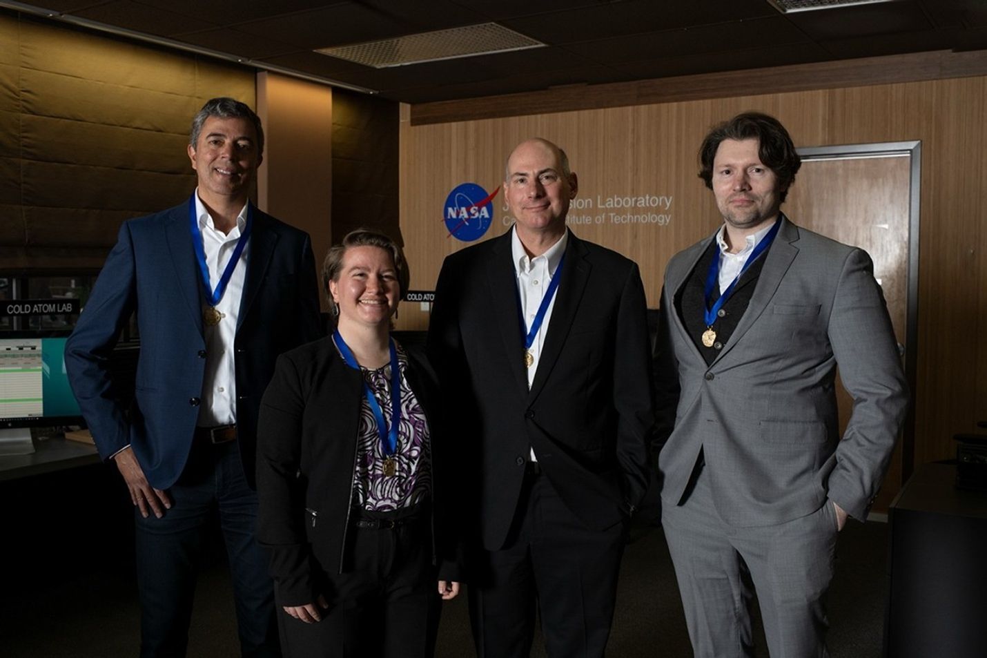
NASA Honor Awards for Cold Atom Lab Team Members
Awarded for notable leadership accomplishments that have significantly influenced NASA’s mission. Sustained leadership and exceptionally high-impact leadership achievements demonstrate the individual’s effectiveness in advancing NASA’s goals and image in present and future terms.
Kamal Oudrhiri – For outstanding leadership of the Cold Atom Laboratory, NASA’s first quantum laboratory in space.
NASA EXCEPTIONAL SCIENTIFIC ACHIEVEMENT MEDALAwarded for exceptional scientific contributions toward achievement of NASA’s mission. This award is given for individual efforts that have resulted in a key scientific discovery or resulted in contribution(s) of fundamental importance in this field or significantly enhanced understanding of the field.
Jason Williams – For exceptional scientific achievements enabling and performing the first pathfinding experiments in quantum sensing of inertial forces with atom interferometry in space.
NASA EXCEPTIONAL PUBLIC ACHIEVEMENT MEDALAwarded for a significant specific achievement or substantial improvement in operations, efficiency, service, financial savings, science, or technology which contributes to the mission of NASA.
Ethan Elliott – For exceptional achievement in generating the first quantum gas mixtures in space and using them to demonstrate dual species matter-wave interferometry for quantum tests.
NASA EARLY CAREER ACHIEVEMENT MEDALThis prestigious NASA medal is awarded for significant performance during the first 10 years of an individual’s career in support of the NASA Mission. The contribution is significant, in that, for an employee who is at such an early phase of career, the contribution has substantially improved the discipline area.
Sarah Rees – For early career achievement in anomaly recovery and complex operation efforts in support of the Cold Atom Laboratory on the International Space Station.
Keep Exploring Discover More Topics From NASA
Cold Atom Laboratory
International Space Station
To view more images, visit the Space Station Gallery.
Jet Propulsion Laboratory
International Space Station Facts and Figures
International Space Station Facts International Space Station Size & Mass
Video: Perseverance Rover’s View of Crater Rim Drive
NASA/JPL-Caltech Photojournal Navigation Downloads Video: Perseverance Rover’s View of Crater Rim Drive
JPEG (659.02 KB)
PIA26647 Animation
MP4 (125.55 MB)
Description
This animation shows Perseverance’s point of view during drive of 807 feet (246 meters) along the rim of Jezero Crater on Dec. 10, 2025, the 1,709th Martian day, or sol, of the mission. Captured over two hours and 35 minutes, 53 Navigation Camera (Navcam) image pairs were combined with rover data on orientation, wheel speed, and steering angle, as well as data from Perseverance’s Inertial Measurement Unit, and placed into a 3D virtual environment. The result is this reconstruction with virtual frames inserted about every 4 inches (0.1 meters) of drive progress.
NASA’s Jet Propulsion Laboratory, which is managed for the agency by Caltech, built and manages operations of the Perseverance rover.
For more about Perseverance: science.nasa.gov/mission/mars-2020-perseverance/
Keep Exploring Discover More Topics From Photojournal
Photojournal
Search Photojournal
Photojournal’s Latest Content
Feedback
Mapping Perseverance’s Route With AI
NASA/JPL-Caltech/UofA Photojournal Navigation Downloads Mapping Perseverance’s Route With AI
PNG (1,003.24 KB)
Description
This annotated image from NASA’s HiRISE (High Resolution Imaging Science Experiment) camera aboard the agency’s Mars Reconnaissance Orbiter image depicts the AI-planned route and the actual route taken by NASA’s Perseverance Mars rover during its 807-foot (246-meter) drive on Dec. 10, 2025, the 1,709th Martian day, or sol, of the mission. The drive was the second of two demonstrations — the first being on Dec. 8 — showing that generative artificial intelligence could be incorporated in the rover’s route planning.
The magenta lines depict the path the rover’s wheels would take if it were to follow AI-processed waypoints, which are indicated with the magenta circles. (Waypoints are fixed locations where the rover takes up a new set of instructions.) The orange lines are based on data downlinked after the drive was complete and depict the actual path the rover took. The short, bold segments of the blue lines at the start of the route, in the upper right, show the portion of the drive that was determined by the mission’s rover drivers and based on imagery taken by the rover of the surface ahead. The surface areas in pale green boxes are called “keep-in zones.” Perseverance’s self-driving software is only allowed to pick routes inside those zones.
The graphic was generated using Hyperdrive, part of the software suite used to plan rover drives and manage the massive influx of engineering data from the Perseverance rover.
NASA’s Jet Propulsion Laboratory, which is managed for the agency by Caltech, built and manages operations of the Perseverance rover.
For more about Perseverance: science.nasa.gov/mission/mars-2020-perseverance/
The University of Arizona in Tucson, operates HiRISE, which was built by BAE Systems in Boulder, Colorado. JPL manages the Mars Reconnaissance Orbiter for SMD.
Keep Exploring Discover More Topics From Photojournal
Photojournal
Search Photojournal
Photojournal’s Latest Content
Feedback
NASA’s Commercial Satellite Data Acquisition Program Releases Archived and Tasked Multispectral Data from Satellogic
- CSDA
- Commercial Data
- CSDA Vendors
- Program Activities
- Pilot Research Projects
- FAQs
- News
3 min read
NASA’s Commercial Satellite Data Acquisition Program Releases Archived and Tasked Multispectral Data from Satellogic This image of an urban area outside of New Orleans, Louisiana, shows the high resolution available from Satellogic’s level 1D Orthorectified multispectral archive and tasked data product now available in the CSDA Program’s Satellite Data Explorer. Credit: CSDA“The mission of the CSDA Program is to identify, evaluate, and acquire data from commercial sources that support NASA’s Earth science research and application goals,” said CSDA Project Manager Dana Ostrenga. “The addition of this product from Satellogic to the SDX demonstrates the CSDA Program’s ongoing commitment to that mission, as well as to our objective of bringing high-quality, Earth observation data from NASA’s commercial partners to the Earth Science community.”
This Level 1D product, which is equivalent to a NASA-defined Level 1C data product, is derived from satellites in Satellogic’s NewSat constellation, each of which carries a multispectral camera offering four bands in visible (red, green, and blue) and near-infrared part of the electromagnetic spectrum. The product provides images covering 25,000 square kilometers (km2) of the Satellogic archive.
Researchers interested in accessing this data product in SDX can use their Earthdata Login for authentication and initiate data download requests. The product includes all associated metadata and documentation, and its use is governed by the United States government plus End User License Agreement (USG EULA)
About SDXThe SDX allows users to search, discover, and access a variety of Global Navigation Satellite System (GNSS), digital elevation model (DEM), synthetic aperture radar (SAR), multispectral, and precipitation radar data acquired through the CSDA program. It also provides streamlined data download, automated quota tracking, and a new coverage map that provides a high-level overview of the spatial coverage of the data discoverable through the SDX for any specified month and year. For a summary of the NASA commercial partner datasets available in SDX, visit the SDX website.
To order data from SDX, users must create an account with and be logged in to NASA Earthdata. (The initial attempt to use SDX will redirect users to Earthdata Login, where they will be prompted to enter their Earthdata credentials and accept the terms of the EULA.) Users must agree to the terms of the EULA before any data can be requested. Note: All data requests must be approved by CSDA data managers.
About the CSDA ProgramNASA’s Earth Science Division (ESD) established the CSDA Program to identify, evaluate, and acquire data from commercial providers that to support NASA’s Earth science research and applications. NASA recognizes the potential of commercial satellite constellations to advance Earth System Science and applications for societal benefit and believes commercially acquired data may also can augment the Earth observations acquired by NASA, and other U.S. government agencies, and NASA’s international partners.
All data from CSDA contract-awarded vendors are evaluated by the investigator-led CSDA project teams that assess the value of adding a vendor’s data to CSDA’s data holdings based on their quality and how they might benefit in the context of NASA Earth science research and applications. To learn more about the program, its commercial partners, data evaluation process, and more, visit the CSDA website.
Learning ResourcesFor more information on the CSDA Program’s SDX, see the SDX user guide.
Detailed information about the Level 1D products is available on the Satellogic website.
Share Details Last Updated Jan 30, 2026 Related Terms Explore More 3 min read Extreme January ColdFollowing a significant winter storm, frigid temperatures lingered in late January 2026 across a vast…
Article
15 hours ago
4 min read The West Faces Snow Drought
Very wet—but very warm—weather in the western U.S. has left many mountainous regions looking at…
Article
2 days ago
3 min read Students Across New England Contribute to Climate Science Through NASA’s GLOBE Green Down
In fall 2025, more than 50 educators and over 1,500 young people across Maine and…
Article
1 week ago
Keep Exploring Discover Related Topics
Missions
Humans in Space
Climate Change
Solar System
