
NASA - Breaking News
NASA’s Chandra Finds Possible Supernova Remnant
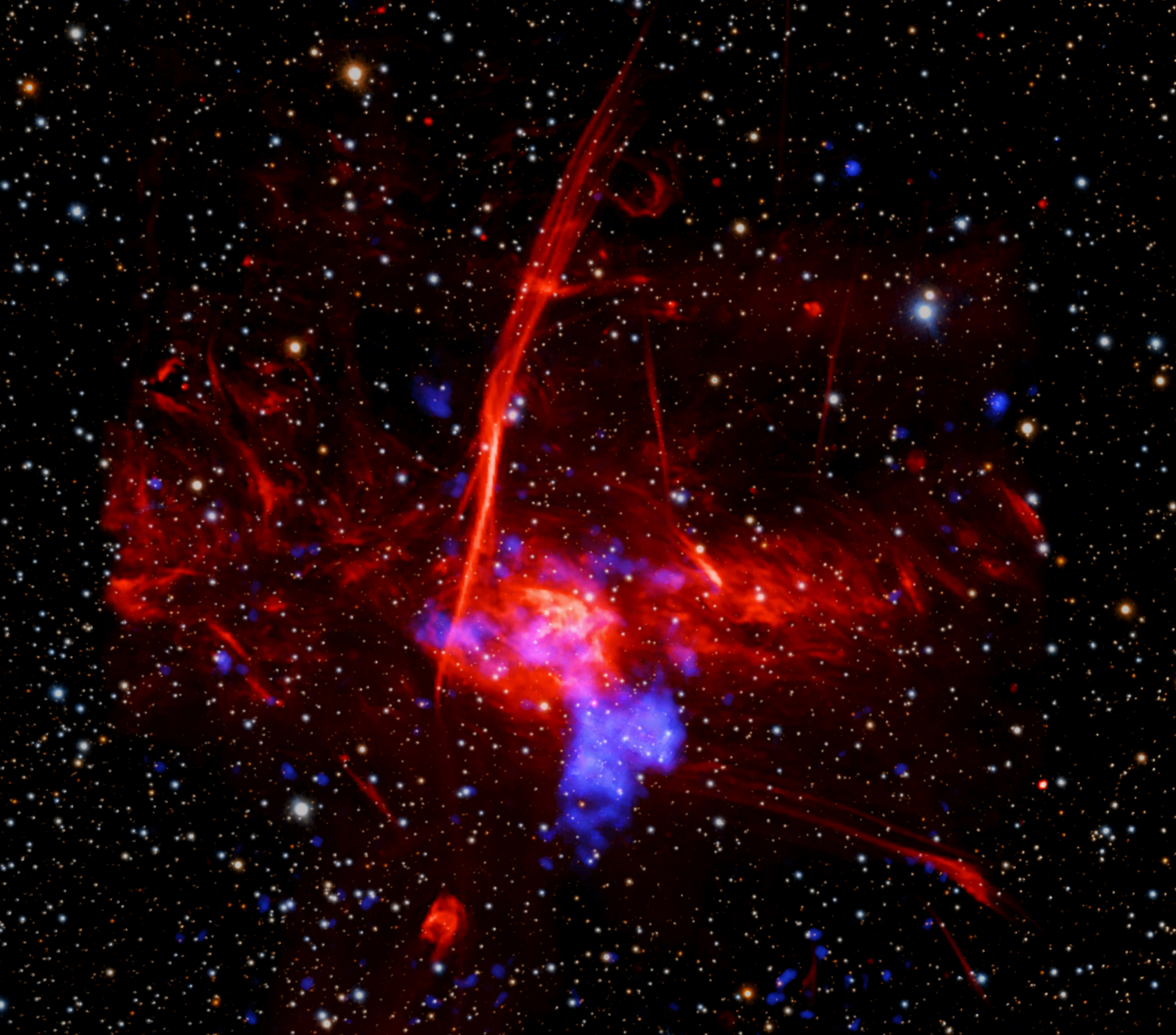
Using data from NASA’s Chandra X-ray Observatory, astronomers may have found a supernova remnant – seen in this June 11, 2026, image – in an intriguing neighborhood in the middle of the Milky Way galaxy. Supernova remnants are the expanding remains of exploded stars and provide elements like iron, oxygen, and silicon that are critical for the formation of planets and for life as we know it to form and flourish.
This new supernova remnant, if confirmed, would be one of the closest ever discovered to the supermassive black hole at the central region of our home galaxy, an exotic region crammed with massive stars, long threads of magnetic fields and dense clouds of gas orbiting rapidly around the Galactic Center.
Read more about this discovery.
Image credit: -ray: NASA/CXC/UCLA/Z. Zhu et al.; ESA/XMM-Newton; Optical: PanSTARRS; Radio: MeerKAT; Infrared (JWST): NASA/ESA/CSA/STScI; Image Processing: NASA/CXC/SAO/L. Frattare and P. Edmonds
NASA to Cover US Spacewalk 95, Host Preview News Conference
NASA astronauts will venture outside the International Space Station on Tuesday, June 30, to replace a wrist joint on the orbital complex’s Canadarm2 robotic arm. The spacewalk is scheduled to begin at approximately 8:35 a.m. EDT.
Experts from NASA and CSA (Canadian Space Agency) will preview the upcoming spacewalk during a news conference at 2 p.m. on Thursday, June 25, on the agency’s YouTube channel. The briefing will take place at NASA’s Johnson Space Center in Houston. Learn how to watch NASA content through a variety of platforms, including social media.
Participants include:
- Bill Spetch, operations and integration manager, International Space Station Program, NASA Johnson
- Fiona Antkowiak, spacewalk flight director, NASA Johnson
- Jason Dyer, deputy liaison manager, CSA
United States-based media interested in attending in person must contact the Johnson newsroom no later than 5 p.m. Wednesday, June 24, at: jsccommu@mail.nasa.gov. Media joining by phone should request dial‑in details by the same deadline. To ask a question, media must dial in no later than 15 minutes before the start of the news conference.
Tuesday, June 30
NASA astronauts Chris Williams and Jessica Meir will exit the station’s Quest airlock to replace a wrist joint that malfunctioned during normal Canadarm2 operations on May 27 after the arm drew elevated motor current and did not move as expected.
Watch NASA’s live U.S. spacewalk 95 coverage beginning at 7 a.m. EDT on NASA+, Amazon Prime, Netflix, and the agency’s YouTube channel. The spacewalk is expected to last roughly six-and-a-half hours.
NASA worked alongside CSA to understand the issue and determined a spacewalk was required to replace the joint using a spare already aboard the space station. Repairs to robotics, like Canadarm2, are normal and expected after more than 25 years of continuous operations, as the system was designed with replaceable components and planned maintenance in mind.
This spacewalk will be the second for Williams and the fifth for Meir. Williams will serve as spacewalk crew member 1 and will wear a suit with red stripes. Meir will serve as crew member 2 and will wear an unmarked suit. It will be the 280th spacewalk in support of space station assembly, maintenance, and upgrades.
To learn more about International Space Station research, operations, and its crews, visit:
-end-
Jimi Russell
Headquarters, Washington
202-358-1100
james.j.russell@nasa.gov
Sandra Jones
Johnson Space Center, Houston
281-483-5111
sandra.p.jones@nasa.gov
NASA’s Webb Finds Clues to Ancient, Distant Origin of Comet 3I/ATLAS
- Webb
- News
- Overview
- Science
- Observatory
- Multimedia
- Team
- More
Image: NASA, ESA, CSA, STScI, Martin Cordiner (CUA, NASA-GSFC); Image Processing: Alyssa Pagan (STScI)
As interstellar comet 3I/ATLAS began moving away from the Sun in December 2025, astronomers took the opportunity to turn NASA’s powerful James Webb Space Telescope in its direction and capture detailed measurements of its chemical components. The comet was freshly warmed from its closest pass by the Sun, and its ancient ice had been converted to a bright coma of gas ideal for observation.
Webb captured detailed data, including chemical ratios of carbon and deuterium, also known as heavy hydrogen, that are not found in solar system comets. The results surprised researchers. Working backward, astronomers used the components that make up comet 3I/ATLAS to understand the environment in which it formed.
A paper detailing the findings published June 22 in the journal Nature.
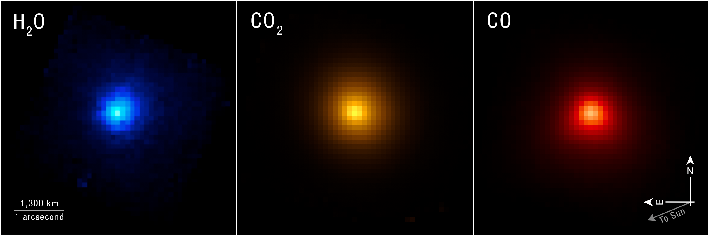
Image: Interstellar Comet 3I/ATLAS (NIRSpec IFU) Researchers used the NIRSpec (Near-Infrared Spectrograph) instrument on NASA’s James Webb Space Telescope to map specific chemical contents of comet 3I/ATLAS as it moved away from the Sun. Image: NASA, ESA, CSA, STScI, Martin Cordiner (CUA, NASA-GSFC); Image Processing: Alyssa Pagan (STScI)The comet’s name comes from its status as the third confirmed interstellar comet, meaning it originated outside the solar system, and the telescope that first spotted it, the NASA-funded ATLAS (Asteroid Terrestrial-impact Last Alert System).
“This was a unique opportunity to study an ancient object from the distant galaxy, probably pre-dating our Sun and solar system,” said astro-chemist Martin Cordiner of NASA’s Goddard Space Flight Center in Greenbelt, Maryland, and lead author of the study. “On the one hand, we get direct insight into that distant time and place, and on the other, we learn something about how unusual our own solar system may be.”
Cordiner and the research team joined astronomers from many sub-disciplines in taking the opportunity to get a look at 3I/ATLAS on its journey through the solar system. They received approval to interrupt Webb’s planned schedule of observations to make use of its NIRSpec (Near-Infrared Spectrograph) instrument to study the comet.
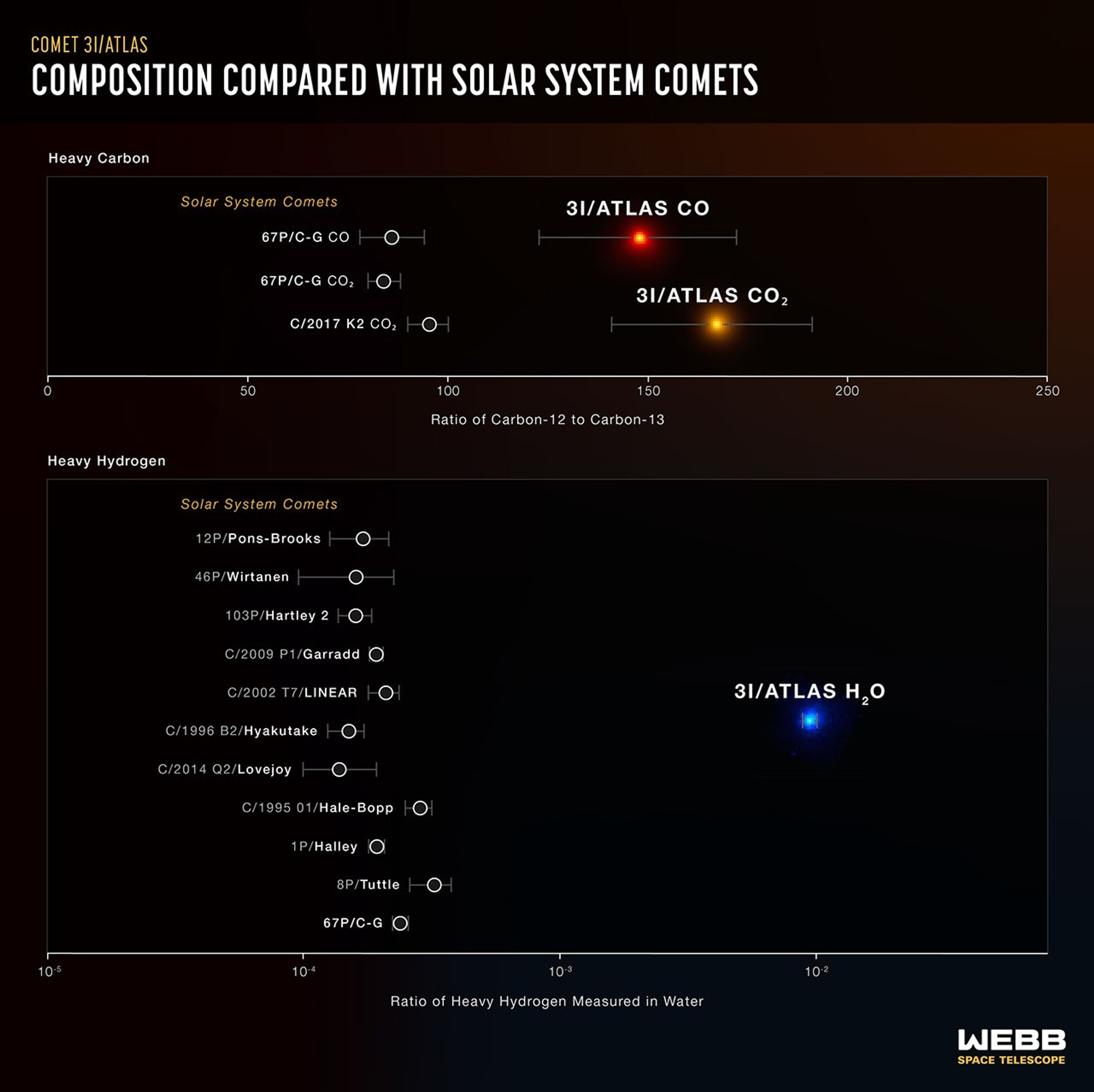
NIRSpec revealed exceptionally high levels of deuterium, about 30 times more than seen in solar system comets. This implies that 3I/ATLAS may have originated in a very cold system much earlier in the history of our galaxy. During its formation, the material that became incorporated into 3I/ATLAS was likely exposed to plenty of radiation, but not any long-term warmth that would have reprocessed its “heavy water” ice, with deuterium, into the type of H2O ice we are familiar with on Earth.
Image: 3I/ATLAS Compared to Solar System Comets These graphs lay out the significant difference in composition between the interstellar comet 3I/ATLAS and comets originating in our solar system. This very specific data helps researchers build a picture of the comet’s original planetary system. Illustration: NASA, ESA, CSA, Martin Cordiner (CUA, NASA-GSFC), Leah Hustak (STScI)Additionally, NIRSpec showed only traces of carbon-13 compared to lighter-weight carbon-12. This also points to a very old origin for 3I/ATLAS, as stellar systems become enriched with carbon-13 over time as generations of stars are born and die in the galaxy. That is why there are higher levels of carbon-13 in our system, around our Sun, which formed relatively recently, 4.5 billion years ago.
The research team estimates that 3I/ATLAS could have formed as long as 10 to 12 billion years ago, during the universe’s “cosmic noon,” when star formation was at its height. Its young origin system was likely ensconced in a relatively cold, dense cloud. The abundance of heavy water shows that 3I/ATLAS spent its formative years in a deeply frozen state.
A separate study using the European Southern Observatory’s Very Large Telescope, led by astronomer Cyrielle Opitom of the University of Edinburgh, complements Webb’s findings with an analysis of 3I/ATLAS’s carbon and nitrogen varieties in the form of the chemical cyanide.
“For us as scientists, finding these rare isotopes is fascinating, but the bigger picture here is looking at the possibilities of prebiotic chemistry elsewhere in the galaxy,” said Stefanie Milam of NASA Goddard and co-author of the study with Cordiner. “So far, we know of only one place in the vast cosmos where chemical ingredients led to life – our solar system, our Earth. Analysis of these interstellar objects is a major step towards learning how common, or uncommon, the conditions for the evolution of life are in the universe.”
The James Webb Space Telescope is the world’s premier space science observatory. Webb is solving mysteries in our solar system, looking beyond to distant worlds around other stars, and probing the mysterious structures and origins of our universe and our place in it. Webb is an international program led by NASA with its partners, ESA (European Space Agency) and CSA (Canadian Space Agency).
To learn more about Webb, visit:
Downloads & Related InformationThe following sections contain links to download this article’s images and videos in all available resolutions followed by related information links, media contacts, and if available, research paper and Spanish translation links.
Related Images & Videos Interstellar Comet 3I/ATLAS (NIRSpec IFU)Researchers used the NIRSpec (Near-Infrared Spectrograph) instrument on NASA’s James Webb Space Telescope to map specific chemical contents of comet 3I/ATLAS as it moved away from the Sun.
3I/ATLAS Compared to Solar System Comets
These graphs lay out the significant difference in composition between the interstellar comet 3I/ATLAS and comets originating in our solar system. This very specific data helps researchers build a picture of the comet’s original planetary system.
Related Links
Read more: NASA’s Webb Detects Methane on Interstellar Comet 3I/ATLAS
Explore more: NASA’s 3I/ATLAS Observation Timeline
Watch: Interstellar Visitor is Fastest Comet Ever Recorded
Watch: ViewSpace | Interstellar Comet Measured
More Webb: News | Images | Science | Home Page
Laura Betz
NASA’s Goddard Space Flight Center
Greenbelt, Maryland
laura.e.betz@nasa.gov
Leah Ramsay
Space Telescope Science Institute
Baltimore, Maryland
Christine Pulliam
Space Telescope Science Institute
Baltimore, Maryland
Research paper published in Nature
Keep Exploring Related Topics James Webb Space Telescope
Webb is the premier observatory of the next decade, serving thousands of astronomers worldwide. It studies every phase in the…
Asteroids, Comets & Meteors
Asteroids, Comets, and Meteors Stories
Exploring Our Solar System with Webb
Signs of Thaw in the Bering Sea
- Earth
- Earth Observatory
- Image of the Day
- EO Explorer
- Topics
- More Content
- About
Tropical Storm Arthur
- Earth
- Earth Observatory
- Image of the Day
- EO Explorer
- Topics
- More Content
- About
Curiosity Blog, Sols 4920-4926: Surveying the Bands
- Curiosity Home
- Science
- News and Features
- Multimedia
- Mars Missions
- Mars Home
3 min read
Curiosity Blog, Sols 4920-4926: Surveying the Bands NASA’s Mars rover Curiosity acquired this image of small butte, “Miraflores,” using its Mast Camera (Mastcam) on June 11, 2026 — Sol 4922, or Martian day 4,922 of the Mars Science Laboratory mission — at 09:12:13 UTC. NASA/JPL-Caltech/MSSSWritten by William Farrand, Senior Research Scientist, Space Science Institute
Earth planning date: Friday, June 12, 2026
Rather than going from stage to stage at a music festival to hear different bands playing different varieties of music, Curiosity has been ascending up Mount Sharp through physical bands of exposed rocks with textural and tonal differences.
Planning for sols 4920 and 4921 were done with the rover in the middle of a unit with a rougher texture and dark-toned bedrock. With the rougher-textured bedrock, brushing wasn’t possible, but APXS chemistry and MAHLI micro-imaging were planned on “as is” bedrock targets “Salto La Cascada” and “Puerto de Rosas.” ChemCam was targeted to perform LIBS spectroscopy on a bedrock target “Kishuara” and a small, layered float rock “La Rosita.” ChemCam’s Remote Micro-Imager (RMI) collected views of the “Mishe Mokwa” butte and another looking at dunes with tonal differences. Mastcam mosaics were collected on the “Valle Grande” channel, “Kimsa Chata” butte, nearby troughs, and the aircraft carrier shaped rock “El Matir.”
Another drive brought Curiosity closer to the upper border of the dark-toned band. Again, brushing of the rocks was not possible, but APXS and MAHLI were collected on dark-toned bedrock targets “Santa Gracia” and “Laguna San Rafael” with ChemCam LIBS also targeting the bedrock. Mastcam mosaics were collected of a layered rock and nearby troughs and a mosaic of the nearby smaller butte, “Miraflores” which displays an interesting layered structure with ragged dark-toned rocks on one side and a stack of dust piled on top (see accompanying image). Other activities included a long-distance RMI mosaic of a bright unit on “Mishe Mokwa”, and Navcam dust-devil surveys in both sols.
Communicating between Earth and Mars has come to seem routine, but at times can still be a challenging endeavor and this was demonstrated to the team on Friday when we did not get a timely downlink of data for the drive planned for Sol 4923. Without these images another drive, in situ examinations, or targeted remote sensing could not be planned. However, there are always interesting things to be done on Mars and the three-sol plan (4924 to 4926) included a 360-degree Mastcam mosaic, the automatic AEGIS targeting of LIBS measurements on each sol, a Navcam dust-devil survey, APXS atmospheric measurements, as well as several other environmental activities.
On Monday, the delayed downlink will be used to plan the first investigation of the next band of surface materials, this one being smooth-textured and light-toned, as well as another drive to continue the surveying of the bands.
-
Want to read more posts from the Curiosity team?
-
Want to learn more about Curiosity’s science instruments?
Article
1 week ago
5 min read Curiosity Blog, Sols 4908-4912: Goodbye Campo Marte, It’s Been Fun!
Article
2 weeks ago
3 min read Curiosity Blog, Sols 4900-4907: Pasadena, We Have a Drill Sample!
Article
3 weeks ago
Keep Exploring Discover More Topics From NASA Mars
Mars is the fourth planet from the Sun, and the seventh largest. It’s the only planet we know of inhabited…
All Mars Resources
Explore this collection of Mars images, videos, resources, PDFs, and toolkits. Discover valuable content designed to inform, educate, and inspire,…
Rover Basics
Each robotic explorer sent to the Red Planet has its own unique capabilities driven by science. Many attributes of a…
Mars Exploration: Science Goals
The key to understanding the past, present or future potential for life on Mars can be found in NASA’s four…
NASA Mission to Study Space Weather Impacts of Earth’s Atmosphere
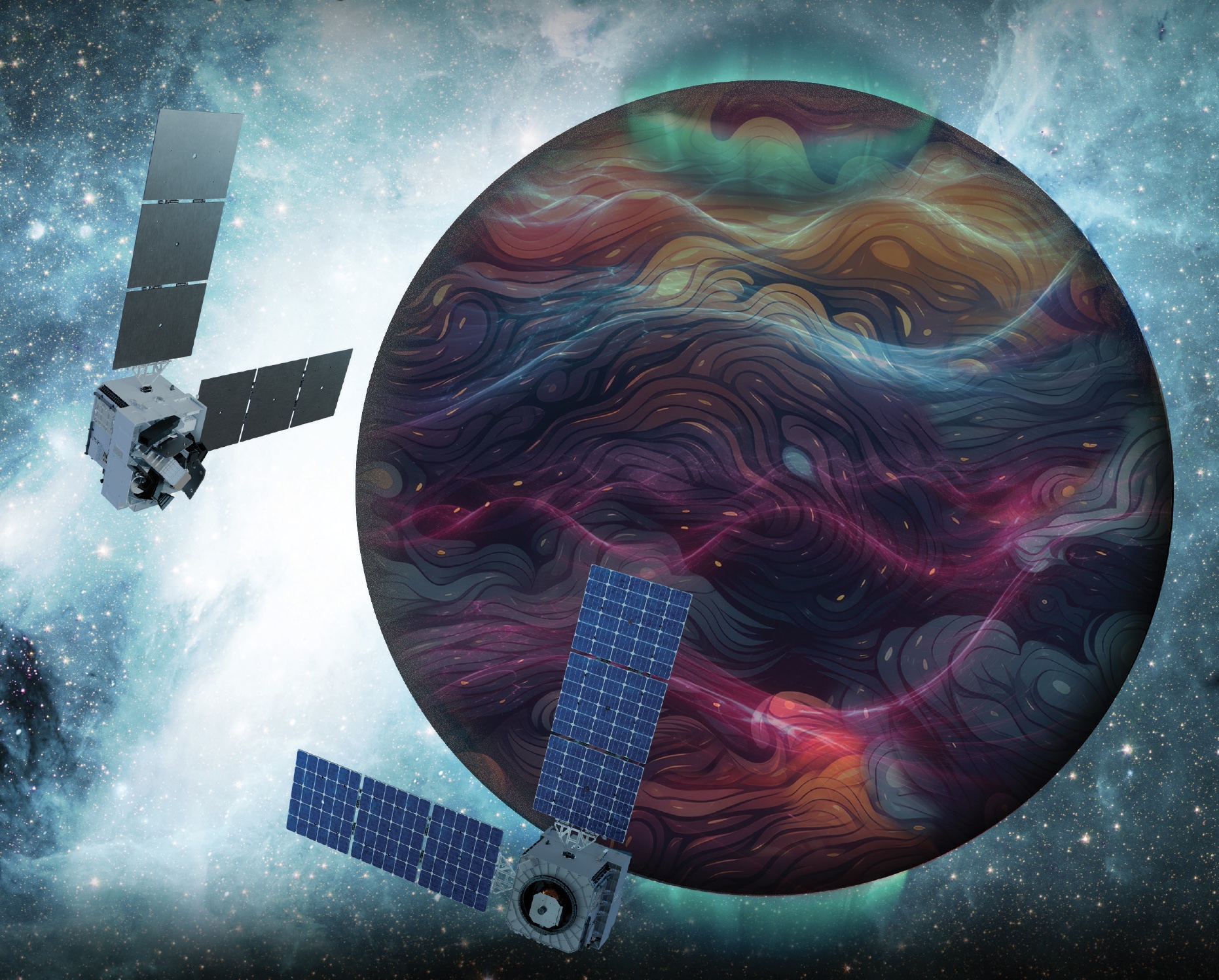
NASA selected a mission concept to research how space weather and dynamics within Earth’s atmosphere influence the space environment and help improve prediction capabilities for impacts on crucial technology, such as GPS and low Earth orbit satellites, as well as astronauts in space.
The DAPHNE (Dynamic Atmosphere-Ionosphere Explorer) mission will enter Phase B of development, which includes planning and design for flight and mission operations. It will use identical twin satellites to study how changes in Earth’s lower atmosphere influence our planet’s upper atmosphere, where space weather is manifested.
“NASA is advancing the United States’ leadership as a space weather-ready nation, and by providing new insights into Earth’s atmosphere we can better predict and prepare for impacts in our daily lives on Earth and in space,” said Nicky Fox, associate administrator, Science Mission Directorate, NASA Headquarters in Washington. “As NASA sends astronauts beyond Earth’s magnetic protection to the Moon, Mars, and beyond, DAPHNE will join the NASA science fleet strategically located across the solar system to provide data that will help mission planners predict and mitigate the effects of space weather for the benefit of all.”
The DAPHNE mission’s low-risk high-return concept will provide coordinated, multi-point measurements of neutral winds, temperature, and composition in the thermosphere. The ionosphere and thermosphere regions are where Earth’s neutral atmosphere transitions into the ionized plasma of space. In this thin shell that surrounds the planet, the atmosphere is in constant motion, shaped by the influence of solar activity and changes in the lower atmosphere and in near-Earth space.
Fundamental observations and physical insights from the DAPHNE mission will incorporate lower-atmospheric energy data to advance space weather predictive capabilities. The mission is led by Aimee Merkel from the Laboratory for Atmospheric and Space Physics at the University of Colorado, Boulder.
The mission will be subject to a confirmation review in 2027, which will assess the progress of the mission and the availability of funds. If confirmed, the total estimated cost of the mission, excluding launch, will not exceed $250 million in fiscal year 2023 dollars, with a mission launch date of no earlier than 2029.
The DAPHNE mission was proposed as a concept study in response to the DYNAMIC (Dynamical Neutral Atmosphere-Ionosphere Coupling) mission announcement of opportunity. Funding and management oversight for this mission is provided by the Solar Terrestrial Probes program at NASA’s Goddard Space Flight Center in Greenbelt, Maryland.
For more information on NASA’s heliophysics missions, visit:
https://science.nasa.gov/heliophysics
-end-
Abbey Interrante / Karen Fox
Headquarters, Washington
202-358-1600
abbey.a.interrante@nasa.gov / karen.c.fox@nasa.gov
NASA Awards Contract for Commercial Satellite Data Acquisition
NASA has selected eight new companies and will acquire new data products from six existing Commercial Satellite Data Acquisition contract holders to expand the range of commercial satellite data available to researchers, civil agencies, and decision-makers. Such measurements supplement NASA’s Earth satellites by contributing high-resolution and frequent observations to enhance the agency’s set of data.
Leveraging commercial data demonstrates NASA’s commitment to strong public-private partnerships, allowing the agency to expand scientific insight while reducing costs and accelerating the delivery of data to researchers and decision-makers.
Collectively, NASA and commercial Earth observations provide insight into our home planet – benefitting Americans, providing environmental intelligence, strengthening disaster response, and improving public safety.
The Commercial Satellite Data Acquisition Program On-Ramp 2 Multiple Award contract is a firm-fixed-price, indefinite-delivery/indefinite-quantity multiple-award contract. The original maximum contract value was $476 million, with a performance period that began in 2023 and continues through Nov. 15, 2028.
Contract awardees are:
- Airbus DS Geo Inc.
- GHGSat Inc.
- Hydrosat Inc.
- ICEYE US Inc.
- ImageSat International
- Kuva US Inc.
- Muon Space Inc.
- Orbital Sidekick Inc.
- OroraTech USA Inc.
- Planet Labs Federal Inc.
- Space Sciences and Engineering LLC, doing business as PlanetiQ
- SATLANTIS US
- Tomorrow Companies Inc., doing business as Tomorrow.io
- Wyvern Inc.
The agency’s Commercial Satellite Data Acquisition mission works to execute a cost-effective way to augment and complement the suite of Earth observations captured by NASA and its partners by identifying, evaluating, and acquiring commercial satellite data.
For more information about NASA’s Commercial Satellite Acquisition program, visit:
https://science.nasa.gov/earth-science/csda
-end-
Liz Vlock
Headquarters, Washington
202-358-1600
elizabeth.a.vlock@nasa.gov
From Suriname to Space: Rohit Goeptar Shares His Journey to NASA
Rohit Goeptar was born into a poor family in Suriname, South America, the kind where both parents work three jobs and they still can only provide food and shelter for their family. At around age six, his family moved to California to start a new life. Only two years later, he moved back to South America with his father while his mother stayed in the United States and remarried. When he was 13, he became a U.S. citizen and he and his brothers returned to live with their mother in California.
At 19, Goeptar joined the U.S. Marine Corps where he spent six years as a technical operator. During one deployment to the Philippines, Goeptar helped set up communication systems for individuals who needed to contact their loved ones after a typhoon ripped through entire towns.
“I was lost, the Marine Corps gave me an opportunity,” Goeptar recalled.
While the Marines taught him useful skills, his life had not been the easiest. He lost not one, but two, fathers to suicide, and a short first marriage ended with him being unhoused on the streets of Kissimmee, Florida, for six months. But Goeptar eventually found his way.
As with most underdog stories, there was another person in the shadows behind his rise to success.
“Your brain works in mysterious ways,” his now wife told him a short while after they met. She then filled out college applications for him, and he eventually applied to NASA’s Kennedy Space Center in Florida.
While raising three kids, going to school full-time pursuing a computer engineering and electrical engineering degree simultaneously, Goeptar got the call that changed his life.
“In spring 2025, I was driving to pick my son up from school when a gentleman from Kennedy calls, telling me he’s seen my resume and do I have time for a quick interview,” Goeptar recounted.
He pulled on the side of the road and took part in an impromptu job interview.
Two weeks later, he had an in-person interview with others from Kennedy and two weeks after that, he had a contractor badge at America’s premier spaceport.
After starting as an intern under the Expendable Launch Vehicle Integrated Support, or ELVIS, contract, then moving to part-time until he graduated from the University of Central Florida (UCF) in Orlando, then full-time at the beginning of 2026, Goeptar was one of the ELVIS contractors who applied and were picked up to become civil servants recently.
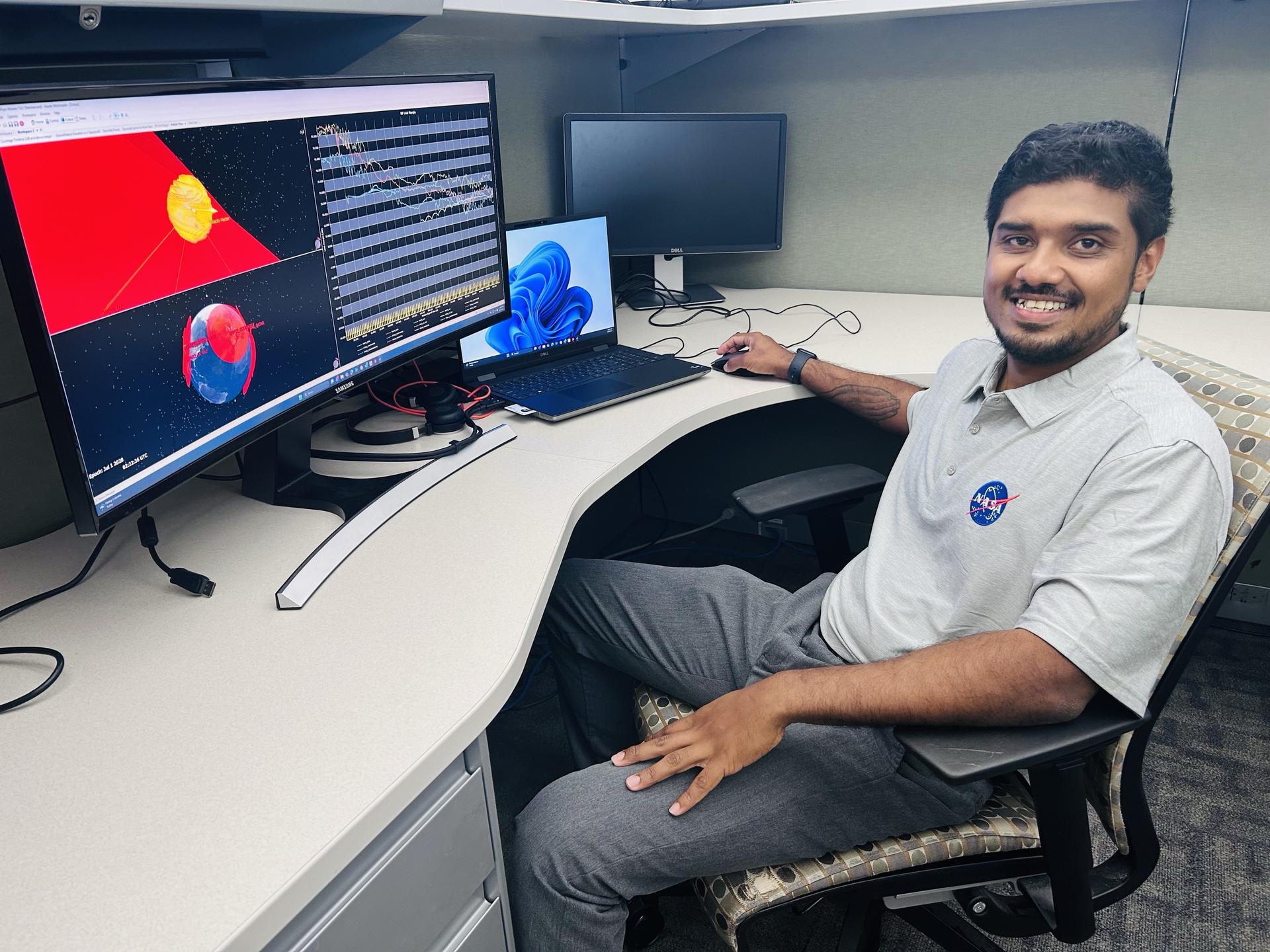
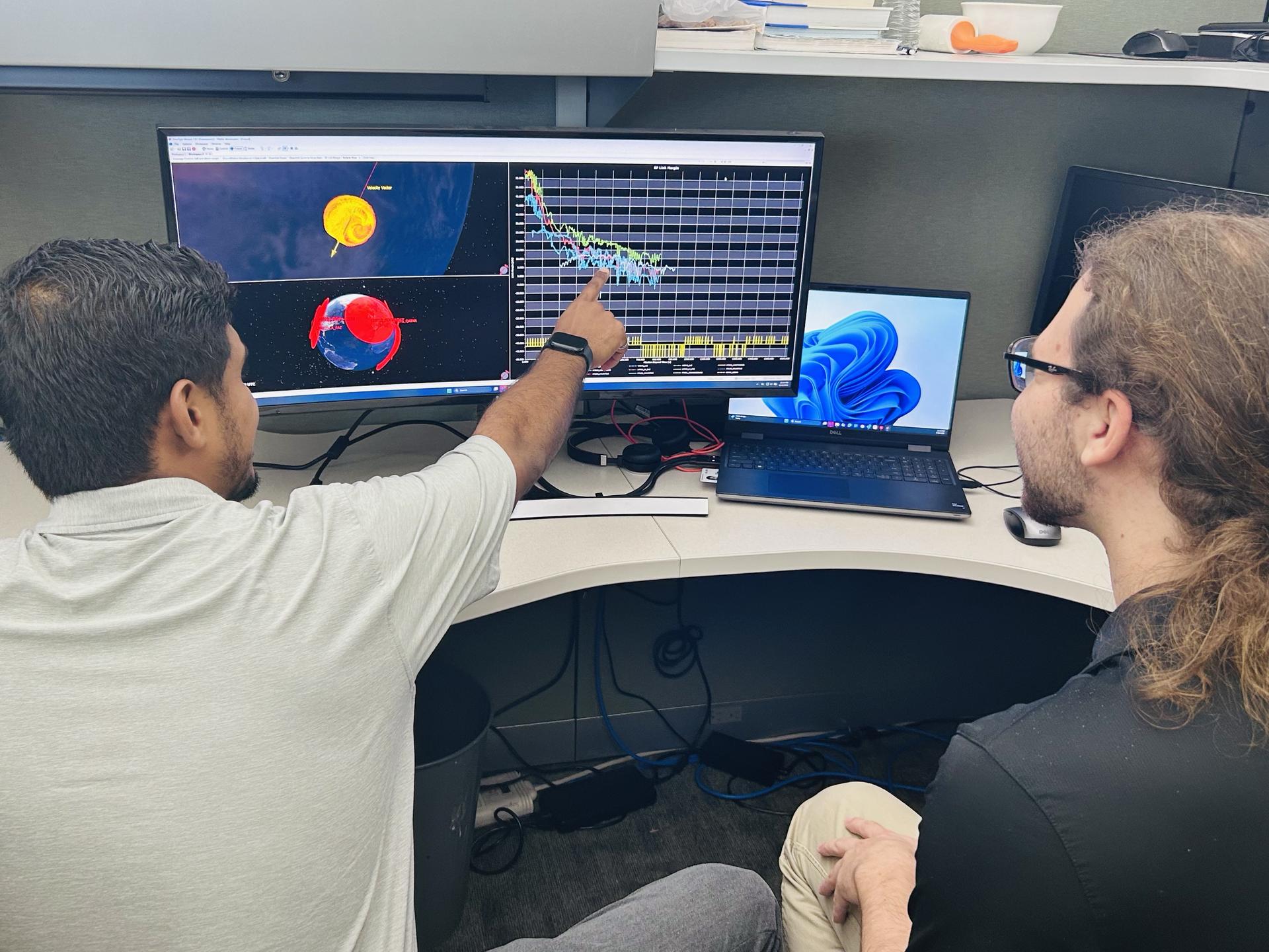
Rohit Goeptar, an electromagnetic/radio frequency analyst with NASA’s Launch Services Program at the agency’s Kennedy Space Center in Florida, reviews a radio frequency link budget analysis for NASA’s Nancy Grace Roman Space Telescope with a colleague. NASA/Amanda GriffinNow an employee of NASA’s Launch Services Program, Goeptar works with electromagnetic interference, electromagnetic compatibility, and radio frequency. It is his job throughout the entirety of the mission to analyze and ensure avionic boxes or anything electrically powered doesn’t interfere with any other systems. He also ensures independent systems are compatible when brought together. And finally, he conducts model radio frequency link analysis for different rockets and science demonstrations payloads. These may belong to NASA or commercial partners, and he is responsible for ensuring uninterrupted communication with the ground. In his short time at Kennedy, Goeptar has worked on Sentinel-6B, JPSS-4 (Joint Polar Satellite System), and IMAP (Interstellar Mapping and Acceleration Probe) missions.
And as far as his wife’s assessment that his brain works differently, he proved that within a year at Kennedy when he noticed an analytical issue his team wasn’t tracking. Once a rocket launches, it does a pitch, yaw, and roll. The analysis the team had been conducting didn’t account for this movement, which meant it wasn’t as accurate as it could be. He presented his solution to the team lead, and it now enables NASA data and partner data to be much more in sync.
“There is no greater feeling, being able to serve. It’s more than serving the public, it’s serving our country. It’s serving the future of our country,” Goeptar said with tears brimming in his eyes. “Being able to give back to that same government that gave me an opportunity to be where I’m at today. There’s no greater feeling than that.”
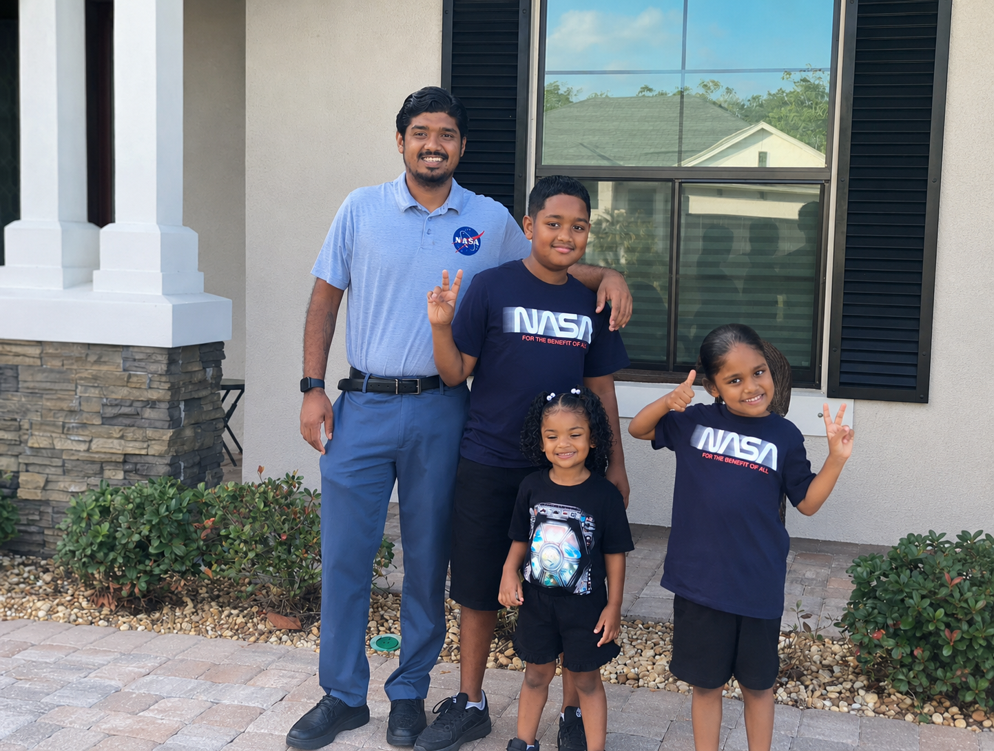
Meanwhile, Goeptar’s 11-year-old takes most of the credit for his landing at the space center, a NASA enthusiast, his son believes he spoke it into existence.
Rohit Goeptar, an electromagnetic/radio frequency analyst with NASA’s Launch Services Program at the agency’s Kennedy Space Center in Florida, poses for a photograph with his children. NASA/Rohit Goeptar“One day he wants to become an astronaut,” Goeptar said with joy on his face. “And I told him I will guide him until the day that I die. Maybe my last mission could be the one my son flies on. I’m not going to stop until that day happens.”
Rohit’s positive streak continues as he recently was accepted into electrical engineering master’s programs at both Johns Hopkins University, and UCF.
Learn more about NASA’s missions online:
Desert Field Test With NASA Advanced Rover Prototype
NASA/JPL-Caltech Photojournal Navigation Downloads Desert Field Test With NASA Advanced Rover Prototype
PNG (27.94 MB)
PIA26701 Figure A
JPEG (26.03 MB)
PIA26701 Figure B
JPEG (951.75 KB)
PIA26701 Figure C
JPEG (16.03 MB)
PIA26701 Figure D
JPEG (16.46 MB)
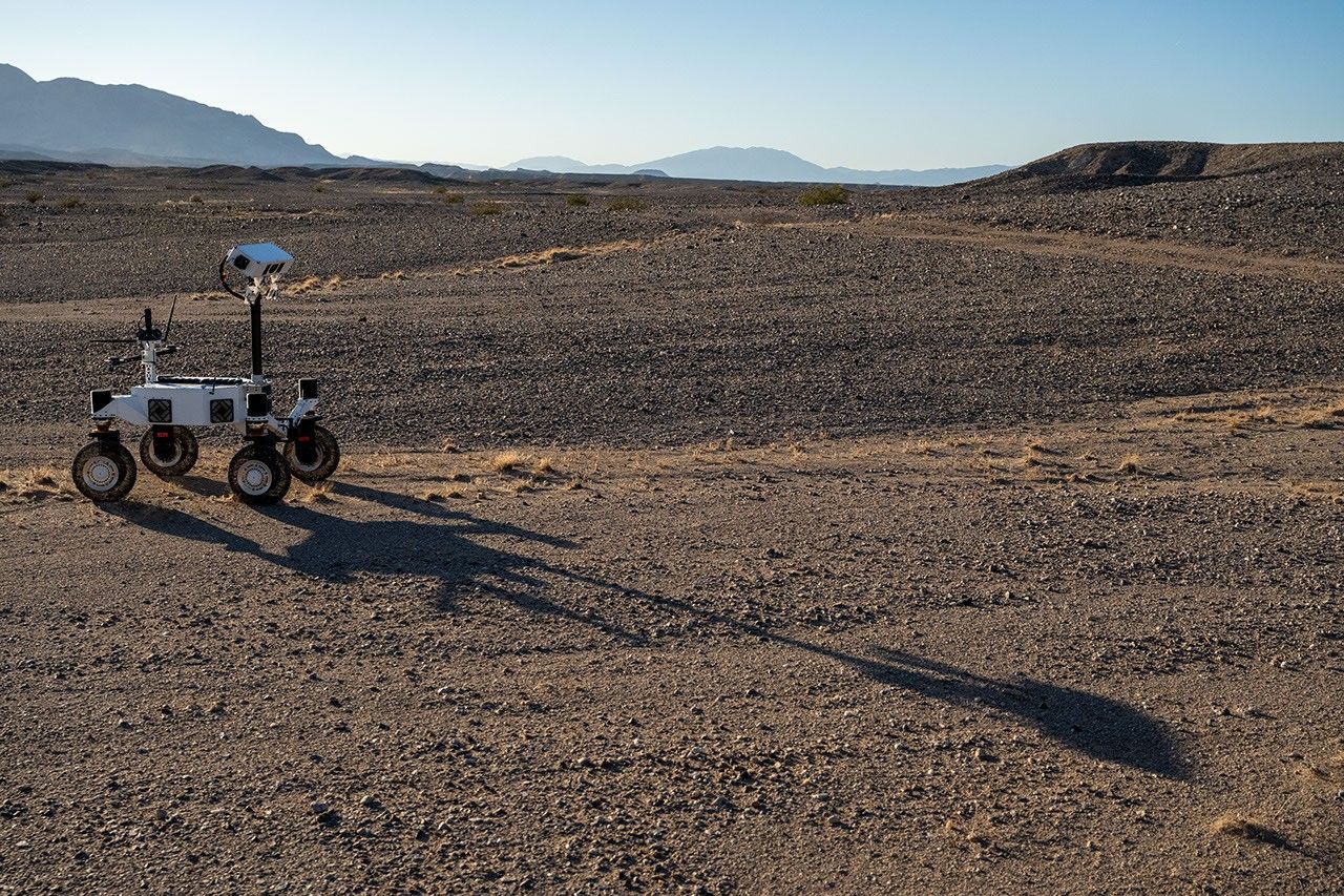
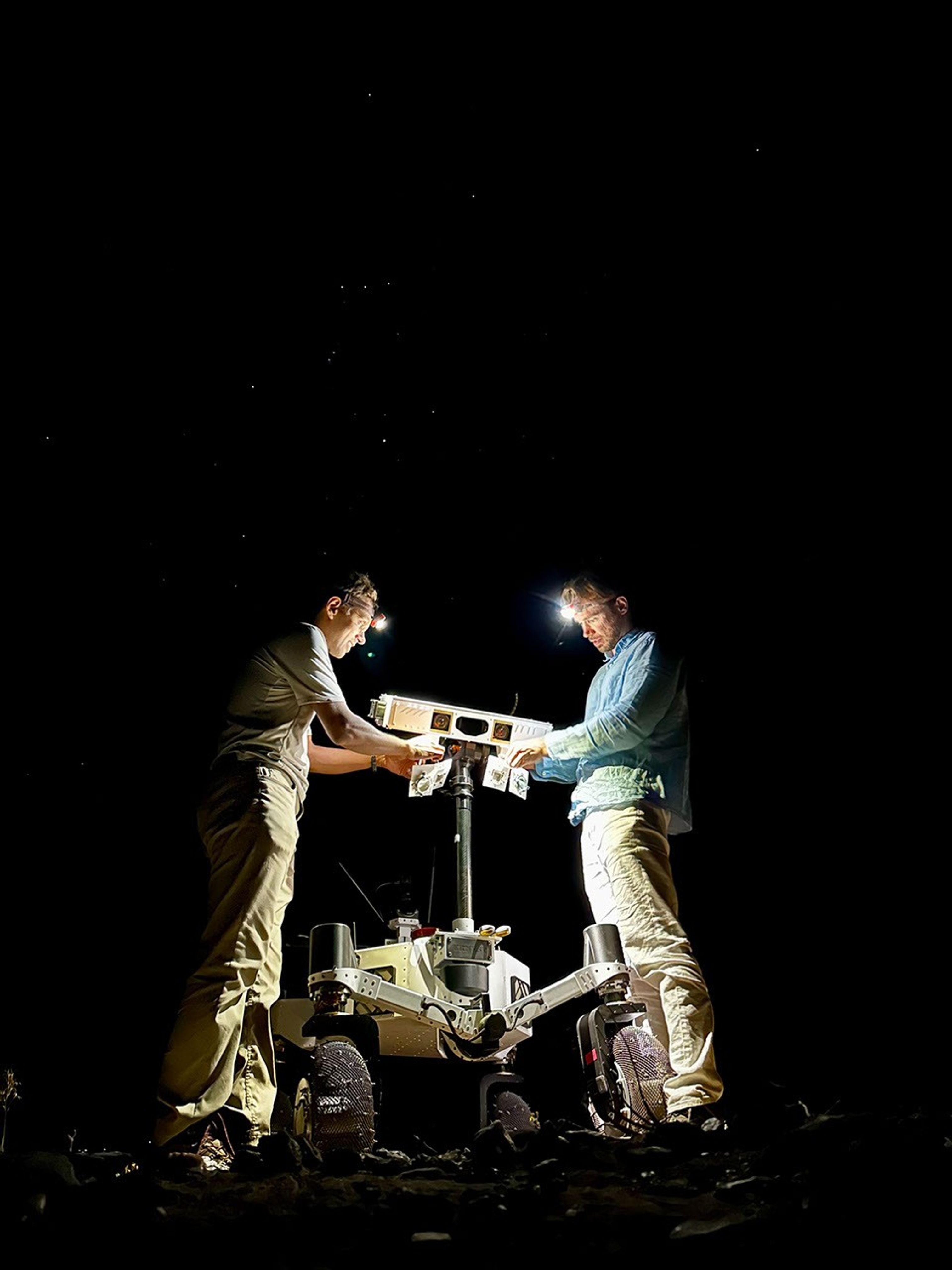
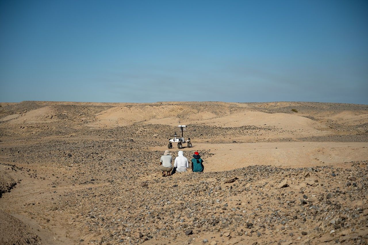
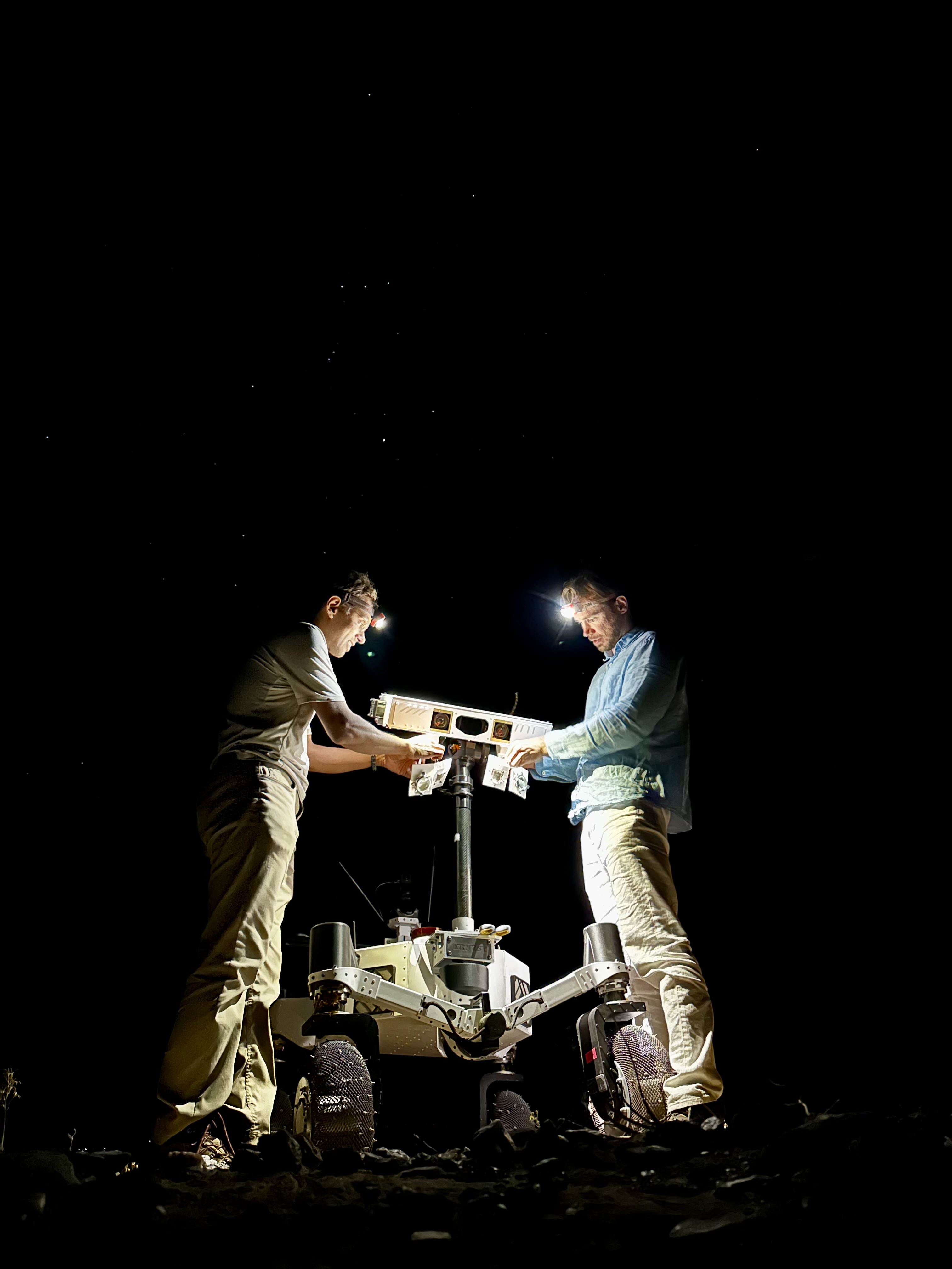
Description
A prototype four-wheel rover developed at NASA’s Jet Propulsion Laboratory with advanced mobility and robotic autonomy capabilities trundled across the Colorado Desert near Plaster City, California, during a field test in March 2026. Called ERNEST (Exploration Rover for Navigating Extreme Sloped Terrain), the rover served here as a testbed for autonomy software developed for a potential lunar mission requiring higher speeds and much greater mileage than can be achieved with current planetary rovers.
ERNEST was trailed by engineers as it traveled about 16 miles over the course of 37 hours of drive time. That’s more than 10 times the speed at which NASA’s Perseverance rover can navigate on Mars. The team also tested how well the rover traveled at dusk, dawn, and nighttime to simulate the experience of large terrain shadows in polar regions on the Moon.
Figure AFigure A shows the rover traveling toward its shadow.
Figure BFigure B shows two team members setting up illuminators on the rover at night.
Figure CFigure C shows three team members observing the rover during its long-range traverse.
Figure DFigure D shows the rover with one wheel up on a rock.
Work on ERNEST began in 2022 and was initially supported by JPL internal research and development funds. It is currently funded by NASA’s Mars Exploration Program and the agency’s Exploration Science Strategy Integration Office under its Science Mission Directorate in Washington. Caltech in Pasadena, California, manages JPL for NASA.
Keep Exploring Discover More Topics From Photojournal
Photojournal
Search Photojournal
Photojournal’s Latest Content
Feedback
NASA Testing Advanced Capabilities for Moon, Mars Rovers
On a bleak stretch of the Colorado Desert in Southern California, a compact four-wheeled rover recently trundled about 16 miles (26 kilometers) with minimal intervention from the team of engineers trailing it. Called ERNEST (Exploration Rover for Navigating Extreme Sloped Terrain), this prototype is being used by NASA to advance both robotic autonomy and the ability to traverse challenging landscapes.
Developed at NASA’s Jet Propulsion Laboratory in Southern California, ERNEST is 4 feet (1.2 meters) long. Not only can it lift each of its mesh wheels to get past obstacles that would stymie Curiosity and Perseverance, NASA’s six-wheeled Mars rovers, but the prototype also has enhanced independent decision-making capabilities. These mobility and autonomy advances could be infused into future missions that will venture to previously inaccessible areas of the Red Planet or the Moon.
ERNEST serves as a testbed for a potential future lunar rover mission requiring high speeds and extreme distances. In a recent field test, the prototype traveled 16 miles over the course of 37 hours, going an order of magnitude above the top speed at which NASA’s current Mars rovers can navigate. Credit: NASA/JPL-CaltechIn the field, ERNEST served as a testbed for a potential future lunar mission requiring higher speeds and much greater mileage than can be accomplished by current rovers. This technology could be used to inform future designs for exploration efforts on the Moon and beyond.
“This testing is helping us refine the mobility hardware and autonomy software to navigate extreme distances across a wide range of terrain and lighting conditions anticipated on the Moon,” said Issa Nesnas, a principal technologist at JPL who led the recent testing as head of autonomy for a NASA mission concept for a potential future long-range lunar rover.
Engineers from JPL set up illuminators after transporting ERNEST for a pre-sunrise test during a seven-day desert field campaign.NASA/JPL-CaltechNesnas’ team is using ERNEST to demonstrate it is possible to build a rover that’s twice as big as the prototype and capable of a long-distance Moon mission. During the recent campaign, ERNEST traveled at speeds up to 0.6 mph (1 kph) over 37 hours of driving, across seven days of intermittent testing. That’s an order of magnitude above the top speed Perseverance and Curiosity can navigate.
“You could do a science road trip across the Moon — or Mars — with this vehicle,” said James Keane, a JPL planetary scientist working on lunar missions.
The initial goal of the team that developed ERNEST was mechanical: to design a relatively simple, low-cost rover that advances the trusted rocker-bogie suspension system featured on every Mars rover since NASA’s Sojourner. This passive system keeps relatively constant weight on all six wheels, thanks to pivot points and struts that enable each one to adapt to the changing surface.
The mobility and autonomy advances developed at JPL for the ERNEST prototype rover could be infused into future NASA missions to previously inaccessible areas of the Red Planet or the Moon. Credit: NASA/JPL-CaltechOn ERNEST, the active suspension lets the rover manage weight distribution among its wheels. Two powered joints in front articulate a gimbal that allows the rover to drive using different gaits like squirming, wheel-walking, and obstacle-climbing. With a clutch mechanism, it can switch between active and passive suspension, which is less terrain capable but more energy efficient. With four steerable wheels, it can drive in any direction, including sideways.
“We started by postulating that we could do better in designing a planetary surface robotic mobility system,” said Hari Nayar, a JPL principal technologist leading the ERNEST team. “While the rocker-bogie system has been very successful over the past 30 years, there’s been a lot of research in that time on mobility and understanding terrain interaction.”
Before arriving at today’s version of ERNEST, the team built two earlier prototypes, each about 2 feet (0.6 meters) long, to test 11 active suspension configurations. In a trailer filled with lunar regolith simulant, they ran experiments at different slope angles over several months before landing on a final design.
Then the team scaled up, including adding a rectangular head mounted on a 4.5-foot-tall (1.4-meter-tall) mast. The hardware was completed in September 2024, but the rover still needed a human operator to joystick it, sending commands to instruct the rover on how to move over obstacles.
In order to train the rover to think on its own, the ERNEST team turned to reinforcement learning, a type of artificial intelligence where the robot learns by interacting with its environment. The Dynamics and Real-Time Simulation Laboratory at JPL developed a high-fidelity virtual testing environment that replicates the rover’s behavior. The team fed the simulator data collected by engineers who documented the response of the actual rover hardware to a variety of terrain types. On a high-performance computing cluster, the team ran many simulations at once, sometimes completing thousands of hours of tests over a single weekend.
After months of virtual training, the ERNEST team was ready to see if the rover could use its new autonomous algorithms to figure out how to drive over terrain features that would halt a passive-suspension rover. They set up an obstacle course with sand ripples, rubble piles, steps, and steep slopes in JPL’s Mars Yard, an outdoor terrain proving ground. Then they watched as the rover maneuvered the terrain on its own. Since then, ERNEST has completed many such courses.
Nayar’s team is starting a new autonomy project which involves integrating the rover’s ability to determine when and how to use its active suspension with longer-range intelligent navigation. The goal is to enable ERNEST to plan an efficient path so that it can tackle surmountable obstacles and circumnavigate hazardous ones. These capabilities could contribute to potential future rover missions encountering formidable landscapes on Mars or more rugged areas of the Moon.
Work on ERNEST began in 2022 was initially supported by JPL internal research and development funds. It is currently funded by NASA’s Mars Exploration Program and the agency’s Exploration Science Strategy and Integration Office in its Science Mission Directorate at NASA Headquarters in Washington. Caltech in Pasadena, California, manages JPL for NASA.
Media Contacts
Karen Fox / Molly Wasser
NASA Headquarters, Washington
240-285-5155 / 240-419-1732
karen.c.fox@nasa.gov / molly.l.wasser@nasa.gov
Melissa Pamer
Jet Propulsion Laboratory, Pasadena, Calif.
626-314-4928
melissa.pamer@jpl.nasa.gov
2026-040
Explore More 4 min read El Niño Is UnderwaySatellite observations of sea surface height indicated that the 2026 event continued to strengthen in…
Article 4 days ago 5 min read NASA’s Quantum Lab Aboard Space Station Gets Chilly Upgrade Article 6 days ago 3 min read Explore JPL to Take Place Oct. 10, 11 Article 6 days ago Keep Exploring Discover More Topics From NASA Earth’s MoonThe Moon makes Earth more livable, sets the rhythm of ocean tides, and keeps a record of our solar system’s…
Robotics
Jet Propulsion Laboratory
Solar System Exploration Program
NASA’s Lucy Reveals Wobbling, Peanut-Shaped Asteroid
Even small asteroids lead complex lives. During its flyby of the asteroid Donaldjohanson last year, NASA’s Lucy spacecraft revealed the asteroid to be a wobbly, peanut-shaped body that has undergone a lot of activity in its relatively short history. Formed as fragments coalesced after a violent collision 155 million years ago, the asteroid was transformed by the small but inexorable force of the Sun’s radiation, all while retaining signs of the brief presence of liquid water in its distant past.
Zooming through the main asteroid belt toward one of the Jupiter Trojan asteroid groups, the Lucy spacecraft collected the first close-up images and other data at Donaldjohanson on April 20, 2025, as it passed 650 miles away from the asteroid. The data revealed that, instead of spinning simply around one axis like most other asteroids and planets, Donaldjohanson has a more complicated two-axis rotation. Scientists also saw Donaldjohanson’s peanut shape and the craters and ridges on its surface.
To view this video please enable JavaScript, and consider upgrading to a web browser that supports HTML5 video
A timelapse video made from images taken by NASA’s Lucy spacecraft as it approached the asteroid Donaldjohanson on April 20, 2025. The L’LORRI (Lucy Long Range Reconnaissance Imager) instrument, the spacecraft’s high-resolution black-and-white imager, collected these images over two hours as the spacecraft rapidly closed in on the asteroid from an initial separation of more than 58,000 miles (93,000 km), until the spacecraft passed a mere 650 miles (1000 km) from the 5-mile- (8 km-) wide asteroid.NASA/Goddard/SwRI/JHU-APLLucy’s encounter with the asteroid was planned as a dress rehearsal for the spacecraft and mission team before its primary asteroid encounters, which begin with Lucy’s flyby of the Trojan asteroid Eurybates on Aug. 12, 2027. The instruments performed as expected, and, as a bonus, scientists got a rare opportunity to study a previously unexplored asteroid up close and to compare it to two asteroids with similar compositions but different histories: Bennu, the target of NASA’s OSIRIS-REx sample-return mission, and Ryugu, the site of JAXA’s (Japan Aerospace Exploration Agency) Hayabusa2 sample-return mission.
Here’s what Lucy’s science team has learned so far from Lucy’s encounter with Donaldjohanson, as reported on June 18 in the journal Science.
Wobbling rotationWith Earth-based telescopes, observers saw fluctuations in the light Donaldjohanson reflects, regular patterns of peaks and valleys, typical of an elongated object rotating once every 10.5 Earth days. But Lucy’s data revealed another pattern: Donaldjohanson appears to be rotating like a wobbly top. Paper authors reported that the asteroid rotates end-over-end once every 10.5 Earth days, and wobbles back and forth around its long axis once every 26.5 days.
To view this video please enable JavaScript, and consider upgrading to a web browser that supports HTML5 video
The asteroid Donaldjohanson is shown slowly rotating in a tumbling, non-principal axis motion, with its angular momentum vector and rotation axes indicated. The surface is colored by gravity slope, which measures the angle between the local surface and the direction of gravity. Higher values (warmer colors) indicate steeper terrain relative to the local gravitational pull. Regions with limited stereo image coverage have been masked out where the shape model is less well constrained.Kel Elkins/NASA’s Science Visualization Studio/DLR Peanut shapeWhile the Earth-based observations hinted at Donaldjohanson’s elongated shape, the Lucy flyby revealed a “bilobate” structure: two lobes connected by a neck, like a peanut. These lobes are likely two fragments from an asteroid collision that gently came together afterward by their mutual gravity.
Donaldjohanson likely rotated at least 10 times faster when it formed, having slowed to its current rate in the last 20 to 60 million years, the team estimates. As it slowed, the balance between the centrifugal force pushing things apart and gravity pulling things together changed and loose rocky material slid down slopes creating the worn-down appearance of many craters, as the flyby images showed.
The paper’s authors say that the asteroid’s slowing rotation is likely caused by a subtle consequence of solar heating known as the YORP effect. Each part of the asteroid’s Sun-warmed surface radiates heat away as infrared light, and that radiation imparts a tiny recoil force to the surface. Because the asteroid’s shape isn’t symmetric, this results in a net torque, or twist, that can change the asteroid’s rotation. Thus, YORP can slow asteroid spins down or speed them up, as in the case of Bennu (once every four hours) and Ryugu (once about every seven hours), which both likely used to rotate much slower than they do today.
Fleeting waterAs it passed by Donaldjohanson at 30,000 mph, Lucy recorded the signatures of iron-rich clay minerals on the surface. These clays must have formed in the distant past with the help of liquid water. However, the exposure must have been brief, Lucy scientists concluded, because iron in clays tends to be replaced with other elements, such as magnesium, as water lingers.
Indeed, scientists saw magnesium-rich clays at Bennu and Ryugu, which suggested prolonged water exposure, perhaps lasting millions of years, when they were still part of larger asteroids.
This difference in water exposure history, and other characteristics, may mean that the parent bodies of these asteroids formed at different times or in different regions of the solar system before relocating to the main belt.
Compare, contrastDonaldjohanson is thought to be made from rocky remnants of a larger, carbon- and water-rich asteroid that collided with another object in the main asteroid belt. Bennu and Ryugu are thought to have formed in the same way and in the same region.
But Donaldjohanson is different. At 155 million years old, it is much younger than Bennu and Ryugu, which formed 1 to 2 billion years ago. Donaldjohanson also has remained in the asteroid belt since birth, while its wandering cousins migrated into orbits around the Sun that bring them close to Earth’s orbit about once a year (which made them perfect close targets for sample return missions).
During its April 20, 2025, encounter with the main-belt asteroid Donaldjohanson, NASA’s Lucy spacecraft discovered evidence for iron-rich clays on the surface using its infrared spectrometer. These clays, which are similar to those found in carbon-rich meteorites such as QUE 97990, indicate that water was briefly present in the asteroid during the distant past.NASA/Goddard/SwRI/Dan Gallagher“It’s helpful for scientists to compare Donaldjohanson with asteroids like Bennu and Ryugu, which are seemingly similar asteroids, because every subtle difference is another clue to our origin story,” said Simone Marchi, Lucy deputy principal investigator and lead author of the study at the Boulder, Colorado, office of the Southwest Research Institute.
“Once we start learning more about the Trojans, a completely different population of space rocks with very different histories, our understanding of solar system formation is destined to be challenged,” said Marchi.
Named after a fossilized skeleton of a human ancestor discovered in Ethiopia in 1974, NASA’s Lucy will be the first mission to explore Jupiter’s Trojan asteroids, a population of well-preserved space rocks that formed early in our solar system’s history and could help scientists understand how the planets formed and moved around before settling in their current configuration.
Download story graphics from NASA’s Scientific Visualization Studio.
About Lucy:Lucy’s principal investigator is based out of the Boulder, Colorado, branch of Southwest Research Institute, headquartered in San Antonio. NASA’s Goddard Space Flight Center in Greenbelt, Maryland, provides overall mission management, systems engineering, and safety and mission assurance. Lockheed Martin Space in Littleton, Colorado, built the spacecraft. Lucy is the 13th mission in NASA’s Discovery Program. NASA’s Marshall Space Flight Center in Huntsville, Alabama, manages the Discovery Program for the agency’s Science Mission Directorate in Washington.
For more information on NASA’s Lucy mission, visit:
LucyNASA’s Goddard Space Flight Center, Greenbelt, Md.
and
Katherine Kretke
Southwest Research Institute, Boulder, Colo.
Media Contacts:Karen Fox / Molly Wasser
Headquarters, Washington
240-285-5155 / 240-419-1732
karen.c.fox@nasa.gov / molly.l.wasser@nasa.gov
Sarah Frazier
NASA’s Goddard Space Flight Center, Greenbelt, Md.
202-853-7191
sarah.frazier@nasa.gov
Zooming through the main asteroid belt toward one of the Jupiter Trojan asteroid groups, the Lucy spacecraft collected the first close-up images and other data at Donaldjohanson on April 20, 2025, as it passed 650 miles away from the asteroid. The data revealed that, instead of spinning simply around one axis like most other asteroids and planets, Donaldjohanson has a more complicated two-axis rotation. Scientists also saw Donaldjohanson’s peanut shape and the craters and ridges on its surface.
Stages of Star Formation
This image, captured by NASA’s James Webb Space Telescope and released on June 5, 2026, shows just a small portion of one of the Orion Molecular Clouds, a long and massive filament of cold gas and dust beyond the Orion Nebula. Every stage of star formation — from the youngest stellar embryos to protoplanetary discs to newly-minted pre-main sequence stars — is contained within this scene which stretches 150 light-years across.
Image credit: ESA/Webb, NASA & CSA, T. Megeath, M. Zamani (ESA/Webb); Acknowledgement: M. H. Özsaraç
Hubble Glimpses Merging Galaxy Clusters
- Hubble Home
- Overview
- Impact & Benefits
- Science
- Observatory
- Team
- Multimedia
- News
- More
2 min read
Hubble Glimpses Merging Galaxy Clusters This NASA Hubble Space Telescope image features a swarm of galaxies in the galaxy cluster called CL0016+1609 or MACS J0018.5+1626.NASA, ESA, H. Ebeling (University of Hawaii), D. Coe (STScI, ESA, JWST); Image Processing: G. Kober (NASA/Catholic University of America)This NASA Hubble Space Telescope image features a galaxy cluster, called CL0016+1609 or MACS J0018.5+1626, that is very bright at X-ray wavelengths and is one of the most extensively studied clusters at X-ray and radio wavelengths. The X-ray observations of this cluster revealed that it is two clusters merging along our line of sight.
Researchers requested time to observe CL0016+1609 with Hubble’s Advanced Camera for Surveys because that data would help them accurately measure the cluster’s dark-matter distribution, which helps them study the merger and the role of CL0016+1609 in the large-scale structure of the universe. Hubble can’t directly see dark matter, but its infrared and visible light observations can detect dark matter’s gravitational lensing effects on the normal matter Hubble observes.
The data in this image also includes observations with Hubble’s Wide Field Camera 3 taken as part of an observing program that obtained the first Hubble infrared images of 46 massive galaxy clusters and looked for distant galaxies gravitationally lensed by these clusters. Called RELICS (Reionization Lensing Cluster Survey), this survey found some 300 high-redshift candidate galaxies lensed by these clusters.
You can see the faint vertical arc of one of these distant galaxies in the image above. Look for it just to the left of the large elliptical galaxies in the center of the image. Another brighter, though shorter arc is visible just above and to the right of the large elliptical galaxies in the center of the image.
Facebook logo @NASAHubble @NASAHubble Instagram logo @NASAHubbleMedia Contact:
Claire Andreoli
NASA’s Goddard Space Flight Center, Greenbelt, MD
claire.andreoli@nasa.gov
Since its 1990 launch, the Hubble Space Telescope has changed our fundamental understanding of the universe.
Hubble’s Galaxies
Hubble Science Highlights
Hubble Images
El Niño Is Underway
- Earth
- Earth Observatory
- Image of the Day
- EO Explorer
- Topics
- More Content
- About
NASA Announces Public-Private Partnership to Advance Mars Science
NASA Wednesday announced a new public‑private partnership to advance Mars science by combining the agency’s scientific leadership with commercial innovation. Under this model, NASA will provide the Aeolus atmospheric‑science instrument payload suite, while Relativity Space supplies the spacecraft, rocket, and cruise operations necessary to deliver the instruments to Mars.
This partnership reflects NASA’s growing commitment to approaches that accelerate discovery, expand mission cadence, and strengthen the foundation for future human exploration. By leveraging commercial investment and development capacity, NASA can focus resources on high‑value science while enabling more frequent opportunities to gather critical data about Mars, data essential to safely navigating the Martian atmosphere and ultimately landing humans on the surface.
“Public-private partnerships like this are a force multiplier for science,” said NASA Administrator Jared Isaacman. “By pairing NASA’s world‑class instruments with commercial innovation and investment, we can deliver more science, more often, and reduce the time it takes to get essential data into the hands of researchers preparing for future human missions to Mars.”
Aeolus, scheduled to launch in 2028, is a NASA‑developed suite of four complementary instruments designed to provide the first integrated, daily, global view of Martian winds, temperatures, dust, and clouds. By improving models for dust, winds, temperature, and seasonal atmospheric behavior, Aeolus will generate the detailed environmental knowledge required to reduce risk for future crewed and uncrewed landings. These measurements will directly inform entry, descent, and landing systems and support safer, more predictable mission planning for astronauts.
Aeolus builds on more than two decades of NASA missions that have studied the Martian atmosphere, including orbiters such as MAVEN (Mars Atmosphere and Volatile Evolution), the Mars Reconnaissance Orbiter, and Mars Odyssey, while taking the foundation laid by earlier missions even further, continuing NASA’s tradition of expanding the frontiers of Mars science. Researchers at NASA’s Ames Research Center in California’s Silicon Valley will design, build, and integrate the payload, while Relativity Space will manage spacecraft development and mission operations.
“As NASA’s Innovation Center of Excellence, Ames is committed to delivering the technologies, capabilities, and creative partnerships that enable the agency’s boldest missions,” said Dr. Eugene Tu, center director, NASA Ames. “Aeolus reflects how innovative collaboration accelerates science and strengthens the foundation needed for one day landing humans on Mars.”
The Aeolus payload suite includes four NASA‑built instruments:
- Doppler Wind and Temperature Sounder (DWTS‑Ozone): Measures wind and temperature profiles from the surface up to approximately 37 miles (60 km). A collaboration with GATS.
- Thermal Limb Sounder (TLS): Provides vertical temperature profiles and observations of dust and water‑ice clouds. A collaboration with Xiomas Technologies.
- Surface Radiometric Sensor Package (SuRSeP): Measures surface energy balance, dust, and cloud properties.
- Wide‑Field Context Camera (WFCC): Captures daily global images of atmospheric activity.
NASA will support operations of science instruments for at least one Martian year, while Relativity Space maintains the spacecraft. As part of the agreement, NASA will develop the data‑processing pipeline needed to transform raw measurements into high‑quality, ready‑to‑use data products for broad scientific use.
This effort is supported under NASA’s first six‑year reimbursable Space Act Agreement, providing a stable framework for sustained collaboration, predictable development, and mission continuity.
Learn more about Mars science at:
-end-
Camille Gallo / Cheryl Warner
Headquarters, Washington
202-358-1600
camille.m.gallo@nasa.gov / cheryl.m.warner@nasa.gov
Jeanne Neal
Ames Research Center, Silicon Valley
650-604-4789
jeanne.c.neal@nasa.gov
Search for Hidden Cosmic Companions in Sun’s Backyard
Some stars have planets. Others are orbited by brown dwarfs, balls of gas too massive to be planets, but too low-mass to be stars. Astronomers love these brown dwarf-star pairs because being paired with a star helps reveal a brown dwarf’s age. Ages of astronomical objects are often hard to measure, but essential for understanding how they form.
Now, you can join NASA’s new Backyard Worlds: Binaries project and help astronomers discover these rare and interesting pairs. As a volunteer, you’ll inspect images from NASA’s Wide-field Infrared Survey Explorer (WISE) space telescope. Brown dwarfs may appear as small dots moving across a field of otherwise static stars.
“We need your help to gain critical insights into these enigmatic cosmic objects,” said project lead Aaron Meisner.
Brown dwarfs are common but mysterious because they are so faint. There’s one for every three or four stars in our corner of the Milky Way galaxy. They are important laboratories for understanding giant planets like Jupiter.
Join the Backyard Worlds: Binaries project today and help astronomers understand where and when brown dwarfs form! You can also try one of our other brown dwarf-related projects: Backyard Worlds: Cool Neighbors! Anyone with a laptop or cell phone can participate. Participation does not require citizenship in any particular country.
Facebook logo @nasascience_ @nasascience_ Instagram logo @nasascience_ Linkedin logo @nasascience_ Share Details Last Updated Jun 17, 2026 Editor NASA Science Editorial Team Related Terms Explore More 4 min read NASA’s Webb Catches Exoplanet Getting RoastedThat’s the latest from researchers analyzing NASA’s James Webb Space Telescope’s observations of HD 80606…
Article
23 hours ago
2 min read Hubble Sees Swarm of Galaxies
Looking somewhat like a swarm of bees returning to their hive, this NASA Hubble Space…
Article
5 days ago
2 min read Be a Clump Scout and Help Reveal Secrets of Stellar Nurseries
Help identify star-forming clumps in galaxy images, and help train machines to do the same.
Article
2 weeks ago
Hubble Sees Swarm of Galaxies
Looking somewhat like a swarm of bees returning to their hive, this NASA Hubble Space Telescope image released on June 12, 2026, features the galaxy cluster MACS0329-0211. Galaxy clusters like MACS0329-0211 are important signposts in the story of how the structure of the universe evolved, and are the ultimate telescopic lenses, placing gravitationally lensed galaxies from the earliest stages of the universe into our view.
Zoom into this galaxy swarm and you will find large, oval-shaped elliptical galaxies, and thin spiral and lenticular galaxies viewed from the edge. We can also see the full, face-on view of spiral galaxies and their curving spiral arms. The image’s upper-right quadrant holds faint arcs of distant galaxies gravitationally lensed by the cluster’s massive gravity. The largest of these arcs appears above the bright oval shape of a giant elliptical galaxy. Closer inspection of the image’s center reveals several bright-white intersecting curves that appear as a distorted figure eight. This may be another distant galaxy whose light was magnified and distorted by this massive cluster’s gravity.
Hubble looked at MACS0329-0211 as part of an observing program of X-ray bright galaxy clusters. Researchers used Hubble’s two main cameras, the Advanced Camera for Surveys and its Wide Field Camera 3, to gather data visible and infrared light from the cluster. Hubble’s ability to see such a broad spectrum of light makes it a valuable tool in understanding the very nature of these galaxy clusters.
Image credit: NASA, ESA, M. Postman (STScI); Image Processing: G. Kober (NASA/Catholic University of America)
Low Water at San Carlos Reservoir
- Earth
- Earth Observatory
- Image of the Day
- EO Explorer
- Topics
- More Content
- About
NASA’s Webb Catches Exoplanet Getting Roasted
- Webb
- News
- Overview
- Science
- Observatory
- Multimedia
- Team
- More
Artwork: NASA, ESA, CSA, Joseph Olmsted (STScI)
4 min read
NASA’s Webb Catches Exoplanet Getting RoastedOne well-done gas giant, coming right up! That’s the latest from researchers analyzing NASA’s James Webb Space Telescope’s observations of HD 80606 b, an exoplanet four times the mass of Jupiter with an extremely elliptical orbit that sweeps close by its Sun-like star. The research team is presenting their study and preliminary findings Tuesday at the 248th meeting of the American Astronomical Society in Pasadena, California.
“Hot Jupiters are already considered some of the most extreme exoplanets we know of, but even among that population, HD 80606 b is one of the most extreme,” said Tiffany Kataria, the study’s principal investigator at NASA’s Jet Propulsion Laboratory in Southern California. “We typically think of hot Jupiters as hot gas giants sitting right next to their stars, but this planet’s highly eccentric orbit creates a completely different beast.”
As the planet plunges close to its star, Webb shows its temperature skyrockets by 1,100 degrees Fahrenheit. Previous studies have shown that radical temperature swings can cause an exoplanet’s chemistry and clouds to change in real time. According to the research team, the dynamic conditions of HD 80606 b make the planet an ideal target to observe these changes with Webb’s powerful instruments.
Image: Artist’s concept exoplanet HD 80606 b This artist’s concept shows exoplanet HD 80606 b being “roasted” as its orbit approaches periastron, the point at which it is closest to its host star, which is similar to our Sun. Artwork: NASA, ESA, CSA, Joseph Olmsted (STScI)“Observing a planet like HD 80606 b is actually very efficient because its unusual orbit, with the corresponding swings in temperature and chemical composition, allow us to gather data under varying conditions in just hours and apply those findings to other hot Jupiters or more conventional exoplanets,” said Laura C. Mayorga, co-investigator on the study and an exoplanet astronomer at the Johns Hopkins Applied Physics Laboratory in Laurel, Maryland.
Measurements of temperature and chemical composition were done with spectroscopy, a technique scientists use to break light into its component colors to reveal information about the composition, temperature, motion, and physical properties of objects in space. The team used Webb’s MIRI (Mid-Infrared Instrument) for an extended observation of HD 80606 b before, during, and after its periastron, or closest pass by its star. During periastron, the planet also passed behind the star from Webb’s perspective in what’s known as a secondary eclipse. The observation was years in the planning, as scheduling the time to catch the planet at this point was complex given its extremely elliptical 111-day orbit, and Webb’s own restrictions on where it can look during specific times of the year, based on Earth’s position in orbit around the Sun.
Researchers say they have only begun to peel back the layers of an incredibly rich dataset, but they can clearly see a dramatic shift in the exoplanet’s temperature. “Webb has shown that the planet’s increase in temperature was even more extreme than we anticipated based on Spitzer data,” said Kataria.
In fact, the planet had already been dubbed the “roasted exoplanet” and even got its own poster in NASA’s popular series. NASA’s now-retired Spitzer Space Telescope laid the groundwork of infrared observations of HD 80606 b, showing that more detailed spectroscopic data from Webb would be especially compelling.
“Spitzer did amazing work on this exoplanet, and now Webb is building on that legacy by enabling us to drill down to distinguish specific chemical signatures like methane and carbon dioxide, which is just amazing progress,” said Ryan Challener, co-author and research associate at the Cornell Center for Astrophysics and Planetary Science. “There’s so much to learn from this one dataset here — we really are just getting started deciphering what Webb has to tell us.”
The James Webb Space Telescope is the world’s premier space science observatory. Webb is solving mysteries in our solar system, looking beyond to distant worlds around other stars, and probing the mysterious structures and origins of our universe and our place in it. Webb is an international program led by NASA with its partners, ESA (European Space Agency) and CSA (Canadian Space Agency).
For more information on Webb, visit:
Downloads & Related InformationThe following sections contain links to download this article’s images and videos in all available resolutions followed by related information links, media contacts, and if available, research paper and Spanish translation links.
Related Images & Videos HD 80606 b (Artist’s Concept)This artist’s concept shows exoplanet HD 80606 b being “roasted” as its orbit approaches periastron, the point at which it is closest to its host star, which is similar to our Sun.
Related Links
Este Artículo en Español – “Telescopio Webb de la NASA Detecta un Exoplaneto Asandose”
Read: Webb’s Impact on Exoplanet Research
Watch: How to Study Exoplanets: Webb and Challenges
Explore: Eyes on Exoplanets
Print: The Roasted Exoplanet Poster
More Webb: News | Images | Science | Home Page
Laura Betz
NASA’s Goddard Space Flight Center
Greenbelt, Maryland
laura.e.betz@nasa.gov
Leah Ramsay
Space Telescope Science Institute
Baltimore, Maryland
Hannah Braun
Space Telescope Science Institute
Baltimore, Maryland
- Este Artículo en Español – “Telescopio Webb de la NASA Detecta un Exoplaneto Asandose”
- HD 80606 b in NASA Exoplanet Catalog
- Roasted Exoplanet poster
- “Hot Jupiter” exoplanets
Keep Exploring Discover More Topics From Webb James Webb Space Telescope
Webb is the premier observatory of the next decade, serving thousands of astronomers worldwide. It studies every phase in the…
Science Overview
Exoplanets
Webb Image Galleries
