
NASA - Breaking News
Johnson’s Jason Foster Recognized for New Technology Reporting Record
Heading into a recent staff meeting for Johnson Space Center’s Business Development & Technology Integration Office, Jason Foster anticipated a typical agenda of team updates and discussion. He did not expect an announcement that he had been named a 2025 Rookie of the Year – Honorable Mention through the Federal Laboratory Consortium’s annual awards program.
Foster was one of only three technology transfer professionals across the federal government to be recognized in the Rookie of the Year category, which is open to early-career individuals with less than three years of experience. “It was definitely a surprise,” he said. “It was quite an honor, because it’s not only representing Johnson Space Center but also NASA.”
Jason Foster recognized at the Federal Laboratory Consortium Award Ceremony as a Rookie of the Year – Honorable Mention.Image courtesy of Jason FosterFoster is a licensing specialist and New Technology Report (NTR) specialist within Johnson’s Technology Transfer Office in Houston. That team works to ensure that innovations developed for aeronautics and space exploration are made broadly available to the public, maximizing their benefit to the nation. Foster’s role involves both capturing new technologies developed at Johnson and marketing and licensing those technologies to companies that would like to use and further develop them.
He describes much of his work as “technology hunting” – reaching out to branches, offices, and teams across Johnson to teach them about the Technology Transfer Office, NTRs, and the value of technology reporting for NASA and the public. “NTRs are the foundation that allows our office to do our job,” he said. “We need to know about a technology in order to transfer it.”
Jason Foster (left) visited NASA’s White Sands Test Facility in Las Cruces, New Mexico, with his colleague Edgar Castillo as part of the Technology Transfer Office’s work to capture new technology and innovations developed at Johnson and affiliated facilities. Image courtesy of Jason FosterFoster’s efforts to streamline and strengthen the reporting and patenting of Johnson’s innovations led to his recognition by the consortium. His proactive outreach and relationship-building improved customer service and contributed to 158 NTRs in fiscal year 2024 – the highest number of NTRs disclosed by federal employees at any NASA center. Foster also proposed a three-month NTR sprint, during which he led a team of seven in an intensive exercise to identify and report new technologies. This initiative not only cleared a backlog of leads for the office, but also resulted in more than 120 previously undisclosed NTRs. “We are still using that process now as we continue processing NTRs,” Foster said. On top of those achievements, he helped secure the highest recorded number of license agreements with commercial entities in the center’s history, with 41 licenses executed in fiscal year 2024.
“I am very proud of my accomplishments, none of it would be possible without the open-mindedness and continuous support of my incredible team,” Foster said. “They have always provided a space to grow, and actively welcome innovation in our processes and workflows.”
Jason Foster educated Johnson employees about the Technology Transfer Office and the importance of submitting New Technology Reports during the center’s annual Innovation Showcase.Image courtesy of Jason FosterA self-described “space nerd,” Foster said he always envisioned working at NASA, but not until much later in his career – ideally as an astronaut. He initially planned to pursue an astrophysics degree but discovered a passion for engineering and fused that with his love of space by studying aerospace, aeronautical, and astronautical engineering instead. In his last semester of college at California Polytechnic State University of San Luis Obispo, he landed an internship at Johnson through NASA’s Office of STEM Engagement. He supported flight software development for crew exercise systems on the International Space Station and future exploration missions. “I got really involved in the Johnson Space Center team and the work, and I thought, what if I joined NASA now?”
He was hired as a licensing specialist on the Technology Transfer team under the JETS II Contract as an Amentum employee shortly after graduating and continually seeks new opportunities to expand his role and skillsets. “The more I can learn about anything NASA’s doing is incredible,” he said. “I found myself in this perfect position where literally my job is to learn everything there is to learn.”
Jason Foster holding up Aerogel during his visit to the Hypervelocity Impact Testing Laboratory at NASA’s White Sands Test Facility in Las Cruces, New Mexico. The visit was part of the Technology Transfer Office’s work to capture new technology and innovations developed at Johnson and affiliated facilities. Image courtesy of Jason FosterFoster celebrates three years with NASA this July. In his time at the agency, he has learned the value of getting to know and understand your colleagues’ needs in order to help them. Before he meets with someone, he takes time to learn about the organization or team they are a part of, the work they are involved in, and what they might discuss. It is also important to determine how each person prefers to communicate and collaborate. “Doing your homework pays dividends,” Foster said. He has found that being as prepared as possible opens doors to more opportunities, and it helps to save valuable time for busy team members.
Jason Foster practices fire spinning on a California beach. Image courtesy of Jason FosterWhen he is not technology hunting, you might find Foster practicing the art of fire spinning. He picked up the hobby in college, joining a club that met at local beaches to practice spinning and capturing different geometric patterns through long exposure photos. “It was kind of a strange thing to get into, but it was really fun,” he said. His love of learning drives his interest in other activities as well. Gardening is a relatively new hobby inspired by a realization that he had never grown anything before.
“It’s a genuine joy, I think, coming across something with curiosity and wanting to learn from it,” he said. “I think it especially helps in my job, where your curiosity switch has to be on at least 90% of the time.”
Explore More 4 min read Laser Focused: Keith Barr Leads Orion’s Lunar Docking Efforts Article 7 days ago 4 min read Johnson’s Paige Whittington Builds a Symphony of Simulations Article 3 weeks ago 9 min read Station Nation: Meet Megan Harvey, Utilization Flight Lead and Capsule Communicator Article 4 weeks agoCuriosity Blog, Sols 4568-4569: A Close Look at the Altadena Drill Hole and Tailings
- Curiosity Home
- Science
- News and Features
- Multimedia
- Mars Missions
- Mars Home
2 min read
Curiosity Blog, Sols 4568-4569: A Close Look at the Altadena Drill Hole and Tailings NASA’s Mars rover Curiosity acquired this image of the “Altadena” drill hole using its Mast Camera (Mastcam) on June 8, 2025 — Sol 4564, or Martian day 4,564 of the Mars Science Laboratory mission — at 13:57:45 UTC. NASA/JPL-Caltech/MSSSWritten by Sharon Wilson Purdy, Planetary Geologist at the Smithsonian National Air and Space Museum
Earth planning date: Wednesday, June 11, 2025
As we near the end of our Altadena drill campaign, Curiosity continued her exploration of the Martian bedrock within the boxwork structures on Mount Sharp. After successfully delivering a powdered rock sample to both the CheMin (Chemistry and Mineralogy) and SAM (Sample Analysis at Mars) instruments, the focus for sols 4568 and 4569 was to take a closer look at the drill hole itself — specifically, the interior walls of the drill hole and the associated tailings (the rock material pushed out by the drill).
In the image above, you can see that the tone (or color) of the rock exposed within the wall of the drill hole appears to change slightly with depth, and the drill tailings are a mixture of fine powder and more solid clumps. If you compare the Altadena drill site with the 42 drill sites that came before, one can really appreciate the impressive range of colors, textures, and grain sizes in the rocks that Curiosity has analyzed over the past 12 years. Every drill hole marks a window into the past and can help us understand how the ancient environment and climate on Mars evolved over time.
In this two-sol plan, the ChemCam, Mastcam, APXS, and MAHLI instruments coordinated their observations to image and characterize the chemistry of the wall of the drill hole and tailings before we drive away from this site over the coming weekend. Outside of our immediate workspace, Mastcam created two stereo mosaics that will image the boxwork structures nearby as well as the layers within Texoli butte. ChemCam assembled three long-distance RMI images that will help assess the layers at the base of the “Mishe Mokwa” hill, complete the imaging of the nearby boxwork structures, and image the very distant crater rim (about 90 kilometers, or 56 miles away) and sky to investigate the scattering properties of the atmosphere. The environmental theme group included observations that will measure the properties of the atmosphere and also included a dust-devil survey.
Share Details Last Updated Jun 13, 2025 Related Terms Explore More 2 min read Curiosity Blog, Sols 4566-4567: Drilling SuccessArticle
2 days ago
4 min read Curiosity Blog, Sols 4563-4565: Doing What We Do Best
Article
5 days ago
4 min read Sols 4561-4562: Prepping to Drill at Altadena
Article
1 week ago
Keep Exploring Discover More Topics From NASA Mars
Mars is the fourth planet from the Sun, and the seventh largest. It’s the only planet we know of inhabited…
All Mars Resources
Explore this collection of Mars images, videos, resources, PDFs, and toolkits. Discover valuable content designed to inform, educate, and inspire,…
Rover Basics
Each robotic explorer sent to the Red Planet has its own unique capabilities driven by science. Many attributes of a…
Mars Exploration: Science Goals
The key to understanding the past, present or future potential for life on Mars can be found in NASA’s four…
NASA, DoD Practice Abort Scenarios Ahead of Artemis II Moon Mission
NASA and the Department of Defense (DoD) teamed up June 11 and 12 to simulate emergency procedures they would use to rescue the Artemis II crew in the event of a launch emergency. The simulations, which took place off the coast of Florida and were supported by launch and flight control teams, are preparing NASA to send four astronauts around the Moon and back next year as part of the agency’s first crewed Artemis mission.
The team rehearsed procedures they would use to rescue the crew during an abort of NASA’s Orion spacecraft while the SLS (Space Launch System) rocket is still on the launch pad, as well as during ascent to space. A set of test mannequins and a representative version of Orion called the Crew Module Test Article, were used during the tests.
The launch team at NASA’s Kennedy Space Center in Florida, flight controllers in mission control at the agency’s Johnson Space Center in Houston, as well as the mission management team, all worked together, exercising their integrated procedures for these emergency scenarios.
Teams with NASA and the Department of Defense (DoD) rehearse recovery procedures for a launch pad abort scenario off the coast of Florida near the agency’s Kennedy Space Center on Wednesday, June 11, 2025.NASA/Isaac Watson“Part of preparing to send humans to the Moon is ensuring our teams are ready for any scenario on launch day,” said Lakiesha Hawkins, NASA’s assistant deputy associate administrator for the Moon to Mars Program, and who also is chair of the mission management team for Artemis II. “We’re getting closer to our bold mission to send four astronauts around the Moon, and our integrated testing helps ensure we’re ready to bring them home in any scenario.”
The launch pad abort scenario was up first. The teams conducted a normal launch countdown before declaring an abort before the rocket was scheduled to launch. During a real pad emergency, Orion’s launch abort system would propel Orion and its crew a safe distance away and orient it for splashdown before the capsule’s parachutes would then deploy ahead of a safe splashdown off the coast of Florida.
Teams with NASA and the Department of Defense (DoD) rehearse recovery procedures for a launch pad abort scenario off the coast of Florida near the agency’s Kennedy Space Center on Wednesday, June 11, 2025. NASA/Isaac WatsonFor the simulated splashdown, the test Orion with mannequins aboard was placed in the water five miles east of Kennedy. Once the launch team made the simulated pad abort call, two Navy helicopters carrying U.S. Air Force pararescuers departed nearby Patrick Space Force Base. The rescuers jumped into the water with unique DoD and NASA rescue equipment to safely approach the spacecraft, retrieve the mannequin crew, and transport them for medical care in the helicopters, just as they would do in the event of an actual pad abort during the Artemis II mission.
The next day focused on an abort scenario during ascent to space.
The Artemis recovery team set up another simulation at sea 12 miles east of Kennedy, using the Orion crew module test article and mannequins. With launch and flight control teams supporting, as was the Artemis II crew inside a simulator at Johnson, the rescue team sprung into action after receiving the simulated ascent abort call and began rescue procedures using a C-17 aircraft and U.S. Air Force pararescuers. Upon reaching the capsule, the rescuers jumped from the C-17 with DoD and NASA unique rescue gear. In an actual ascent abort, Orion would separate from the rocket in milliseconds to safely get away prior to deploying parachutes and splashing down.
Teams with NASA and the Department of Defense (DoD) rehearse recovery procedures for an ascent abort scenario off the coast of Florida near the agency’s Kennedy Space Center on Thursday, June 12, 2025. NASA/Isaac WatsonRescue procedures are similar to those used in the Underway Recovery Test conducted off the California coast in March. This demonstration ended with opening the hatch and extracting the mannequins from the capsule, so teams stopped without completing the helicopter transportation that would be used during a real rescue.
Exercising procedures for extreme scenarios is part of NASA’s work to execute its mission and keep the crew safe. Through the Artemis campaign, NASA will send astronauts to explore the Moon for scientific discovery, economic benefits, and to build the foundation for the first crewed missions to Mars – for the benefit of all.
“Cosmic Dawn” Screening at Greenbelt Cinema
Attendees line up to enter the theater for a screening of the new NASA+ documentary “Cosmic Dawn: The Untold Story of the James Webb Space Telescope,” Wednesday, June 11, 2025, at the Greenbelt Cinema in Greenbelt, Maryland. Following the screening, Jacob Pinter, host of NASA’s Curious Universe podcast, led a discussion with Sophia Roberts, a NASA video producer who documented the Webb project, and Paul Geithner, former deputy project manager for Webb.
Featuring never-before-seen footage, Cosmic Dawn offers an unprecedented glimpse into the assembly, testing, and launch of NASA’s James Webb Space Telescope.
Image credit: NASA/Joel Kowsky
Hubble Studies a Spiral’s Supernova Scene
- Hubble Home
- Overview
- Impact & Benefits
- Science
- Observatory
- Team
- Multimedia
- News
- More
2 min read
Hubble Studies a Spiral’s Supernova Scene This NASA/ESA Hubble Space Telescope image features the barred spiral galaxy IC 758. ESA/Hubble & NASA, C. KilpatrickThis serene spiral galaxy hides a cataclysmic past. The galaxy IC 758, shown in this NASA/ESA Hubble Space Telescope image, is situated 60 million light-years away in the constellation Ursa Major.
Hubble captured this image in 2023. IC 758 appears peaceful, with its soft blue spiral arms curving gently around its hazy barred center. However, in 1999, astronomers spotted a powerful explosion in this galaxy. The supernova SN 1999bg marked the dramatic end of a star far more massive than the Sun.
Researchers do not know exactly how massive this star was before it exploded, but will use these Hubble observations to measure the masses of stars in SN 1999bg’s neighborhood. These measurements will help them estimate the mass of the star that went supernova. The Hubble data may also reveal whether SN 1999bg’s progenitor star had a companion, which would provide additional clues about the star’s life and death.
A supernova represents more than just the demise of a single star — it’s also a powerful force that can shape its neighborhood. When a massive star collapses, triggering a supernova, its outer layers rebound off its shrunken core. The explosion stirs the interstellar soup of gas and dust out of which new stars form. This interstellar shakeup can scatter and heat nearby gas clouds, preventing new stars from forming, or it can compress them, creating a burst of new star formation. The cast-off layers enrich the interstellar medium, from which new stars form, with heavy elements manufactured in the core of the supernova.
Text Credit: ESA/Hubble
Facebook logo @NASAHubble @NASAHubble Instagram logo @NASAHubbleMedia Contact:
Claire Andreoli (claire.andreoli@nasa.gov)
NASA’s Goddard Space Flight Center, Greenbelt, MD
Since its 1990 launch, the Hubble Space Telescope has changed our fundamental understanding of the universe.
Hubble’s Galaxies
Homing in on Cosmic Explosions
Hubble’s Night Sky Challenge
NuSTAR Art + Coloring Pages
Jun 12, 2025
PNG (187.75 KB)
NuSTAR Coloring Page – Spacecraft (PDF)
Jun 12, 2025
PDF (485.00 KB)
Art inspired by the NuSTAR Mission. A coloring page for NASA’s NuSTAR mission. Downloads NuSTAR Coloring Page – The Sun (PNG)
Jun 12, 2025
PNG (171.45 KB)
NuSTAR Coloring Page – The Sun (PDF)
Jun 12, 2025
PDF (432.73 KB)
Art inspired by the NuSTAR Mission. A coloring page for NASA’s NuSTAR mission. Downloads NuSTAR Coloring Page – Stellar Remains (PNG)
Jun 12, 2025
PNG (160.71 KB)
NuSTAR Coloring Page – Stellar Remains (PDF)
Jun 12, 2025
PDF (411.75 KB)
A coloring page for NASA’s NuSTAR mission. Downloads
View All
NuSTAR Coloring Page – X-ray Binaries (PNG)
Jun 12, 2025
PNG (163.95 KB)
NuSTAR Coloring Page – X-ray Binaries (PDF)
Jun 12, 2025
PDF (474.45 KB)
Art inspired by the NuSTAR Mission. A coloring page for NASA’s NuSTAR mission. Downloads NuSTAR Coloring Page – Spiral Galaxies (PNG)
Jun 12, 2025
PNG (195.06 KB)
NuSTAR Coloring Page – Spiral Galaxies (PDF)
Jun 12, 2025
PDF (474.45 KB)
A coloring page for NASA’s NuSTAR mission. Downloads NuSTAR Coloring Pages – X-rays (PNG)
Jun 12, 2025
PNG (168.61 KB)
NuSTAR Coloring Pages – X-rays (PDF)
Jun 12, 2025
PDF (502.45 KB)
Downloads All NuSTAR Coloring Pages (PDF)
Jun 12, 2025
PDF (2.56 MB)
NASA’s SLS Rocket: Booster Separation Motors
NASA’s SLS (Space Launch System) solid rocket boosters are the largest, most powerful solid propellant boosters to ever fly. Standing 17 stories tall and burning approximately six tons of propellant every second, each booster generates 3.6 million pounds of a thrust for a total of 7.2 million pounds: more thrust than 14 four-engine jumbo commercial airliners. Together, the SLS twin boosters provide more than 75 percent of the total thrust at launch. Each booster houses eight booster separation motors which are responsible for separating the boosters from the core stage during flight.
At the top of each booster is the frustum—a truncated cone-shaped structure that, along with the nose cone, forms the aerodynamic fairing. This frustum houses four of the separation motors, while the remaining four are located at the bottom within the aft skirt.
Image Credit: NASA/Kevin O’Brien
For more information on the Artemis Campaign, visit:
https://www.nasa.gov/feature/artemis/
News Media ContactJonathan Deal
Marshall Space Flight Center, Huntsville, Ala.
256-544-0034
jonathan.e.deal@nasa.gov
Far Out
Pismis 24, the star cluster seen here in an image released on Dec. 11, 2006, lies within the much larger emission nebula called NGC 6357, located about 8,000 light-years from Earth. The brightest object in the picture was once thought to be a single star with an incredibly large mass of 200 to 300 solar masses. That would have made it by far the most massive known star in the galaxy and would have put it considerably above the currently believed upper mass limit of about 150 solar masses for individual stars. Measurements from NASA’s Hubble Space Telescope, however, discovered that Pismis 24-1 is actually two separate stars, and, in doing so, “halved” their mass to around 100-150 solar masses each.
Image credit: NASA, ESA and Jesús Maíz Apellániz (Instituto de Astrofísica de Andalucía, Spain); Acknowledgment: Davide De Martin (ESA/Hubble)
NASA’s Hurricane Science, Tech, Data Help American Communities
- Earth
- Explore
- Science at Work
- Multimedia
- Data
- For Researchers
- About Us
ISS Astronaut/Earth Observatory
- NASA supports hurricane preparedness and response by providing satellite data and science before, during, and after storms.
- During hurricane season, NASA delivers timely flood maps, power outage insights, landslide risk assessments, and more to state and federal partners.
- NASA tests innovative technologies, from AI models to mini satellites, to enhance how we monitor hurricanes and their impacts.
- NASA’s long-term tracking of wind, ocean heat, and atmospheric moisture improves understanding of where hurricanes might form and intensify.
With the Atlantic hurricane season underway, NASA is again gearing up to produce cutting-edge research that strengthens the nation’s ability to prepare for and respond to severe weather. From satellite imagery of our planet to improved storm modeling, the agency’s work supports communities in anticipating and reducing the impacts of hurricanes.
In 2024, hurricanes including Helene and Milton showed NASA’s wide-ranging capabilities. As the storms approached the United States, the agency’s network of satellites and scientists swung into action. Within hours of landfall, NASA’s Disasters Response Coordination System was supplying emergency managers and others with flood maps, power outage assessments, and other crucial data.
“People might be surprised how deeply NASA is involved in hurricane science,” said Scott Braun, a research meteorologist at NASA’s Goddard Space Flight Center in Greenbelt, Maryland. “We are not the agencies issuing forecasts or warnings, but our technologies and science are making fundamental contributions to how we understand, predict, and respond to these storms.”
Disaster Response Powered by NASAWhen hurricanes strike, NASA’s Disasters Response Coordination System aids state and federal agencies, producing and sharing imagery and data, including the NASA Disasters Mapping Portal, which offers tools to assess storm damage.
One crucial tool is NASA’s Black Marble product suite, produced and maintained by NASA Goddard. Using data from the Visible Infrared Imaging Radiometer Suite (VIIRS), researchers and others can map nighttime lights and detect power outages.
Unlike traditional outage maps, which often show only county-level data, NASA’s Black Marble can provide a more detailed view. It offers calibrated, daily observations, enabling high-confidence tracking of neighborhood-level impacts. Emergency response teams in Florida, for instance, have used this imagery to assess conditions near hazardous waste sites before heading into the field after a hurricane.
before after
The state faced widespread power outages after winds from Hurricane Helene snapped trees, tore off roofs, and toppled power lines. View the full story NASA Earth Observatory/Lauren Dauphin beforeafter
The state faced widespread power outages after winds from Hurricane Helene snapped trees, tore off roofs, and toppled power lines. View the full story NASA Earth Observatory/Lauren Dauphin
before
after
Scientists with NASA’s Black Marble processed data from VIIRS on the NOAA-NASA Suomi NPP satellite to show how power outages darkened Augusta, Georgia, before and after Hurricane Helene. View the full story
CurtainToggle2-Up
Image Details
Other NASA technologies map flooding. Scientists at NASA’s Marshall Space Flight Center in Huntsville, Alabama used the European Space Agency’s Sentinel-1 synthetic aperture radar data and other data from the NASA/U.S. Geological Survey Landsat satellites and ESA’s Sentinel-2 to track flooding after multiple hurricanes in 2024, including Helene and Milton.
These maps were shared through the NASA Disasters Mapping Portal with state and federal emergency managers responding to storms’ impacts in Florida, North Carolina, South Carolina, and elsewhere.
“The ability to see floodwaters and landscape changes gives communities a critical edge during response and recovery,” said Shanna McClain, disasters program manager for NASA’s Earth Science Division at NASA headquarters in Washington. “It helps decision-makers act faster when every minute counts.”
Hurricanes don’t just knock out power or trigger flooding — they can also loosen mountains. After Hurricane Helene, NASA scientists partnered with USGS to tackle a different threat: landslides throughout the southern Appalachian Mountains. NASA’s Landslide Hazard Assessment for Situational Awareness tool, developed at NASA Goddard, can help spot landslide-prone areas by combining different troves of satellite data.
“The landslide model brings together a wide range of Earth science,” said Thomas Stanley, a research scientist at NASA Goddard. “It’s a real convergence of satellite observations — soil moisture, precipitation, elevation — each one adding a key piece to the puzzle.”
NASA and USGS used rainfall data and modeling to estimate landslide hazards in the Appalachians following Hurricane Helene, highlighting high-risk zones across western North Carolina. NASA/USGSIn the days during and after Helene, a NASA-USGS team adapted this model to incorporate ground-based rainfall measurements. “This collaboration proved crucial during the critical first days when lingering clouds prevented direct satellite imaging of landslides,” said Kate Allstadt, a research geophysicist at USGS. “Combining NASA and USGS landslide models guided aerial reconnaissance over four states and helped prioritize areas for detailed mapping.”
NASA Disasters Response coordinators also partnered with USGS to manually map likely landslide areas in North Carolina, South Carolina, and Virginia, using high-resolution satellite imagery. This partnership enabled early warnings to agencies such as the North Carolina Geological Survey about potential landslide zones before visual confirmation was possible.
Tracking Hurricanes in Near Real TimeAs hurricanes gather strength over warm ocean waters, NASA’s satellites begin tracking them. One effort providing essential data on hurricanes is the Global Precipitation Measurement (GPM) mission, a collaboration between NASA and the Japan Aerospace Exploration Agency. Passing over storms once or twice per day, the GPM core satellite captures high-resolution data on rainfall intensity and distribution.
“The GPM mission gives us an inside look at where a storm is dropping the most rain and how intense it is,” said George Huffman, GPM project scientist at NASA Goddard. “That kind of information helps forecasters make better predictions and gives communities more time to prepare for flooding and dangerous conditions.”
Huffman’s team leads NASA’s IMERG (Integrated Multi-satellitE Retrievals for GPM) product, which combines GPM Core Observatory data with observations from other satellites to generate near real-time, global rainfall estimates every 30 minutes. For example, IMERG tracked the record-breaking rainfall that fell during Hurricane Harvey in 2017, when parts of Texas saw more than 50 inches of rain.
Satellite-based rainfall data can be especially vital when a big storm like Harvey or Helene knocks out ground-based rain measurements, Huffman said.
Watch Hurricane Harvey as it makes landfall in Texas and Louisiana in 2017. The visualization depicts precipitation measured by the GPM mission, highlighting record-shattering rainfall over Texas and Louisiana. Blue is frozen precipitation, while green to red is rainfall. NASA’s Scientific Visualization StudioNASA also is working to turn precipitation data into practical flood predictions. One such effort, led by NASA-funded hydrologist Ed Beighley at Northeastern University in Boston, merges rainfall estimates from the GPM mission with National Weather Service river discharge models and surface water mapping methods to identify areas likely to experience flooding.
During Hurricane Helene, his team provided early versions of these flood maps to the North Carolina Department of Health and Human Services.
“In some cases, like with Helene, we could see where disasters were likely to be declared just from the rainfall data — days before the disaster declarations were made official,” Beighley said. “That kind of near real-time information could really help counties and health departments prepare and coordinate response efforts.”
That same focus on improving early flood prediction was at the heart of NASA’s response to Hurricane Debby when it made landfall in Florida in August 2024. At NASA Marshall, the Short-term Prediction Research and Transition (SPoRT) team used its Land Information System to track soil moisture levels, crucial for understanding the potential for flooding.
The team’s Streamflow-AI model — a machine learning tool trained to predict how rivers respond to rainfall — also forecasted rising waters in small streams and creeks in Florida and the Carolinas.
“The streamflow tool is used pretty heavily by the National Weather Service now to help inform flood forecasts, which then filters down to evacuation orders,” said Patrick Duran, a NASA Marshall research scientist with SPoRT.
NASA SPoRT’s Streamflow-AI model shows the flooding potential for the Swannanoa River in Asheville, North Carolina, during and after Hurricane Helene. NASA SPoRT Reinventing the Tech That Sees Into StormsNASA doesn’t just collect data on hurricanes or aid in their aftermath — it is redefining the technology we use to observe and understand them. This work is not only improving forecasts and warnings but also helping to fuel the growth of America’s commercial satellite industry.
Take NASA’s TROPICS mission. Short for Time-Resolved Observations of Precipitation structure and storm Intensity with a Constellation of Smallsats, TROPICS represents a fundamental shift in how we might monitor hurricanes from space. Rather than relying solely on intermittent passes by larger satellites, TROPICS uses a group of small, lower-cost satellites working in concert to provide more frequent observations of tropical storm systems — offering a complementary approach to storm monitoring.
During Hurricane Helene, the TROPICS satellites tracked the storm through nearly its entire life cycle, capturing data on its rapid intensification from a tropical depression to a powerful category 4 hurricane before landfall in Florida’s Big Bend region.
Each TROPICS satellite carries a microwave radiometer. Unlike optical sensors, this instrument can see through clouds, making it ideal for tracking storms. The TROPICS’ radiometers are tuned to detect temperature, moisture, and precipitation patterns inside hurricanes.
“The TROPICS mission is really good at providing images of the structure of a storm, showing how well defined the eye is, which is key for improving forecasting,” said William Blackwell, TROPICS principal investigator at MIT Lincoln Laboratory in Massachusetts.
NASA’s TROPICS mission monitored Hurricane Helene throughout its life cycle. This visualization shows how the tropical depression rapidly intensified into a category 4 hurricane before hitting Florida and then moving inland. NASA’s Scientific Visualization StudioTomorrow.io, an American weather company, is using radiometer technology derived from TROPICS as it develops tools for commercial weather forecasting. The company also is working to adapt radar technology first tested on NASA’s RainCube mission.
RainCube, a small satellite about the size of a shoebox developed by NASA’s Jet Propulsion Laboratory in Southern California, operated from 2018 to 2020. It used radar to study precipitation, sending signals toward Earth and analyzing how long they took to bounce back, and how strong they were after reflecting off raindrops, snowflakes, and cloud ice.
Full-scale satellites have been using radar technology to make that kind of measurement for years. “The key thing with RainCube wasn’t bringing in new science,” said Simone Tanelli, RainCube principal scientist at JPL. “Instead, it was showing that we could give you similar data with a box that’s roughly 100 times smaller in volume than a full-size satellite.”
NASA also tests how other small, lower-cost instruments could transform how we monitor tropical storms. Two such tools — COWVR, short for Compact Ocean Wind Vector Radiometer measures ocean surface winds, and TEMPEST, short for Temporal Experiment for Storms and Tropical Systems tracks atmospheric water vapor — were launched to the International Space Station in 2021.
Using technology and designs from JPL and other NASA teams, TEMPEST and COWVR already are proving their value. Their data has been used by the U.S. Joint Typhoon Warning Center to help track and forecast powerful storms, such as Tropical Cyclone Mandous in December 2022.
Data from the COWVR and TEMPEST instruments aboard the ISS was used to create this image of Tropical Cyclone Mandous, which forecasters used to understand the December 2022 storm’s intensity and predict its path toward southern India. U.S. Joint Typhoon Warning Center/U.S. Naval Research LaboratoryNASA researchers also are investigating lightning, which has emerged as a key clue in predicting rapid storm intensification, a dangerous phase of the hurricane life cycle that is one of the most difficult aspects of hurricane forecasting. Spikes in lightning activity, especially in the eyewall, can be an early sign that a storm is about to strengthen quickly.
The agency’s SPoRT project is researching how lightning data from the Geostationary Lightning Mapper can improve hurricane forecasting. This sensor provides a nearly continuous view of lightning activity over oceans and in remote land regions that have fewer weather observations. The instrument rides aboard NOAA’s (National Oceanic and Atmospheric Administration) GOES weather satellites.
“By studying the size and energy of lightning flashes inside hurricanes, we’re learning how they might signal whether a storm is about to intensify or weaken,” said Duran. “It’s an evolving area of research with a lot of potential.”
During Hurricane Helene, SPoRT’s lightning analyses revealed a burst of strong, frequent flashes in the eyewall just before the storm surged from category 2 to category 4 intensity. That’s exactly the kind of signal researchers hope to detect more reliably in the future.
Bright, large lightning flashes seen in Hurricane Helene’s eyewall, captured by NASA SPoRT’s Geostationary Lightning Mapper viewer, indicate the storm’s rapid intensification from category 2 to 4 just hours before landfall. NASA SPoRTNASA frequently uses its airplanes to test new hurricane tech, too. In one recent example, scientists from NASA’s Langley Research Center in Hampton, Virginia, flew a cutting-edge 3-D Doppler wind lidar system across the United States, including making passes through the edges of Hurricane Helene. The instrument is designed to capture high-resolution wind data that can improve predictions of rapidly evolving storms, such as hurricanes and severe thunderstorms, where accurate wind observations are essential, but often lacking.
Braun compared these multiple data streams — from TROPICS, GPM, and other instruments — to medical imaging. “Think about how doctors use different types of scans like X-rays, MRIs, and ultrasound to understand what’s happening inside a patient’s body,” he said. “We’re doing something similar with hurricanes. Each system gives us a different view of the storm’s internal structure and environment, with the goal of improving forecasts.”
Watching For Hurricane Warning SignsLong before a hurricane takes shape, NASA satellites are already scanning the global ocean and atmosphere, closely tracking the conditions that give rise to powerful storms. One of the most important indicators is sea surface temperature.
NASA combines data from multiple satellites and sensors — such as the Moderate Resolution Imaging Spectroradiometer (MODIS) and VIIRS — to produce sea surface temperature maps like JPL’s Multi-scale Ultra-high Resolution Sea Surface Temperature product and SPoRT’s Sea Surface Temperature Composite product. These global maps, updated daily, support users such as the National Weather Service.
“Having high-resolution, reliable sources of sea surface temperature data is extremely useful,” said Brian McNoldy of the University of Miami, who studies hurricanes. “From one day to the next, these datasets help identify which parts of the tropical Atlantic are above or below average. That information lets forecasters anticipate where storms might strengthen or weaken.”
Hurricane Milton rapidly intensified to category 5 strength over warm gulf waters. View the full story NASA Earth Observatory/Wanmei LiangOcean surface temperatures are only part of the story. NASA also monitors sea surface height with missions such as Sentinel-6 Michael Freilich and SWOT (Surface Water and Ocean Topography), using these measurements as indicators for deeper ocean heat content, a key source of energy fueling hurricanes.
Other NASA-built satellites and sensors measure atmospheric moisture, ocean surface winds, and atmospheric stability, all essential factors influencing whether a storm strengthens or dissipates.
NASA also uses its aircraft to study early storm development up close. In 2022, the agency’s Convective Processes Experiment-Cabo Verde airborne campaign flew off the northwest coast of Africa to study weather systems that can give rise to hurricanes.
The team focused in part on African easterly waves — swirling disturbances in the atmosphere that often become the seeds of Atlantic storms. One of the waves they observed later developed into Tropical Storm Hermine. The mission also gathered data that same year just before hurricanes Fiona and Ian formed.
“The strength of NASA’s pre-storm monitoring lies in both the breadth of measurements we take and the decades-long consistency behind them,” said Will McCarty, manager of weather programs at NASA Headquarters.
“By combining data on sea surface temperature, ocean heat content, wind patterns, and more, we can see early on when conditions align dangerously — often before a storm visibly forms,” McCarty said. “It’s how we turn early warning into early action.”
About the Author Emily DeMarcoShare
Details Last Updated Jun 13, 2025 Related Terms Explore More 1 min read Leaf Year: Seeing Plants in Hyperspectral ColorPACE now allows scientists to see three different pigments in vegetation, helping scientists pinpoint even…
Article
7 days ago
6 min read What NASA Is Learning from the Biggest Geomagnetic Storm in 20 Years
Article
1 month ago
6 min read NASA Data Helps Map Tiny Plankton That Feed Giant Right Whales
Article
1 month ago
Keep Exploring Discover More Topics From NASA Earth
Your home. Our Mission. And the one planet that NASA studies more than any other.
Explore Earth Science
Earth Science in Action
NASA’s unique vantage point helps us inform solutions to enhance decision-making, improve livelihoods, and protect our planet.
Earth Multimedia & Galleries
NASA Sensor on Space Station Eyes Contamination off California Coast
4 min read
Preparations for Next Moonwalk Simulations Underway (and Underwater) Instruments in space are helping scientists map wastewater plumes flowing into the Pacific Ocean from the heavily polluted Tijuana River, seen here with the San Diego sky-line to the north. NOAAProof-of-concept results from the mouth of the Tijuana River in San Diego County show how an instrument called EMIT could aid wastewater detection.
An instrument built at NASA’s Jet Propulsion Laboratory to map minerals on Earth is now revealing clues about water quality. A recent study found that EMIT (Earth Surface Mineral Dust Source Investigation) was able to identify signs of sewage in the water at a Southern California beach.
The authors of the study examined a large wastewater plume at the mouth of the Tijuana River, south of Imperial Beach near San Diego. Every year, millions of gallons of treated and untreated sewage enter the river, which carries pollutants through communities and a national reserve on the U.S.-Mexico border before emptying into the Pacific Ocean. Contaminated coastal waters have been known to impact human health — from beachgoers to U.S. Navy trainees — and harm marine ecosystems, fisheries, and wildlife.
For decades scientists have tracked water quality issues like harmful algal blooms using satellite instruments that analyze ocean color. Shades that range from vibrant red to bright green can reveal the presence of algae and phytoplankton. But other pollutants and harmful bacteria are more difficult to monitor because they’re harder to distinguish with traditional satellite sensors.
A plume spreads out to sea in this image captured off San Diego by the Sentinel-2 satellite on March 24, 2023. Both a spectroradiometer used to analyze water samples (yellow star) and NASA’s EMIT identified in the plume signs of a type of bacterium that can sicken humans and animals.SDSU/Eva ScrivnerThat’s where EMIT comes in. NASA’s hyperspectral instrument orbits Earth aboard the International Space Station, observing sunlight reflecting off the planet below. Its advanced optical components split the visible and infrared wavelengths into hundreds of color bands. By analyzing each satellite scene pixel by pixel at finer spatial resolution, scientists can discern what molecules are present based on their unique spectral “fingerprint.”
Scientists compared EMIT’s observations of the Tijuana River plume with water samples they tested on the ground. Both EMIT and the ground-based instruments detected a spectral fingerprint pointing to phycocyanin, a pigment in cyanobacteria, an organism that can sicken humans and animals that ingest or inhale it.
‘Smoking Gun’Many beachgoers are already familiar with online water-quality dashboards, which often rely on samples collected in the field, said Christine Lee, a scientist at JPL in Southern California and a coauthor of the study. She noted the potential for EMIT to complement these efforts.
“From orbit you are able to look down and see that a wastewater plume is extending into places you haven’t sampled,” Lee said. “It’s like a diagnostic at the doctor’s office that tells you, ‘Hey, let’s take a closer look at this.’”
Lead author Eva Scrivner, a doctoral student at the University of Connecticut, said that the findings “show a ‘smoking gun’ of sorts for wastewater in the Tijuana River plume.” Scrivner, who led the study while at San Diego State University, added that EMIT could be useful for filling data gaps around intensely polluted sites where traditional water sampling takes a lot of time and money.
EMIT’s Many UsesThe technology behind EMIT is called imaging spectroscopy, which was pioneered at JPL in the 1980s. Imaging spectrometers developed at JPL over the decades have been used to support areas ranging from agriculture to forest health and firefighting.
When EMIT was launched in July 2022, it was solely aimed at mapping minerals and dust in Earth’s desert regions. That same sensitivity enabled it to spot the phycocyanin pigments off the California coast.
Scrivner hadn’t anticipated that an instrument initially devoted to exploring land could reveal insights about water. “The fact that EMIT’s findings over the coast are consistent with measurements in the field is compelling to water scientists,” she said. “It’s really exciting.”
To learn more about EMIT, visit:
https://earth.jpl.nasa.gov/emit/
News Media ContactsJane J. Lee / Andrew Wang
Jet Propulsion Laboratory, Pasadena, Calif.
626-379-6874 / 818-354-0307
jane.j.lee@jpl.nasa.gov / andrew.wang@jpl.nasa.gov
Written by Sally Younger
2025-078
Share Details Last Updated Jun 12, 2025 Related Terms Explore More 12 min read NASA’s Hurricane Science, Tech, Data Help American CommunitiesWith hurricane season underway, NASA is gearing up to produce cutting-edge research to bolster the…
Article 4 days ago 3 min read Studying Storms from Space Station Article 4 days ago 4 min read Welcome Home, Expedition 72 Crew! Article 5 days ago Keep Exploring Discover Related TopicsMissions
Humans in Space
Climate Change
Solar System
NASA, Museum to Launch Junior Pilot School for Young Innovators
3 min read
Preparations for Next Moonwalk Simulations Underway (and Underwater) Students from Tropico Middle School in Rosamond, California, build their own paper planes as part of a project during NASA Aero Fair on April 9, 2025.NASA/Genaro VavurisA new generation of aerospace explorers will soon embark on a hands-on summer experience focusing on careers in science, mathematics, engineering, and technology (STEM). This month, NASA’s Armstrong Flight Research Center in Edwards, California, and the Flight Test Museum Foundation will launch the 2025 Junior Test Pilot School.
Held at Blackbird Airpark and Joe Davies Heritage Airpark in Palmdale, California, this six-week program invites elementary-aged students to step into the shoes of test pilots and engineers from 9 a.m. to 2 p.m. Mondays through Fridays, June 16 through July 25. Registration is free through participating school districts and the Flight Test Museum. Students will have direct access to legendary aircraft such as A-12, SR-71, U-2, F-86 Sabre, and NASA Boeing 747 Space Shuttle Carrier Aircraft.
The Junior Test Pilot School combines authentic NASA-designed curriculum, immersive aerospace activities, and direct engagement with engineers, test pilots, and scientists to inspire future aerospace professionals in the Antelope Valley – home to one of the nation’s highest concentrations of STEM careers.
“This program offers more than a glimpse into aerospace, it provides students a hands-on opportunity to solve real-world problems and see themselves in future STEM roles,” said Dr. Amira Flores, program integration manager for NASA’s California Office of STEM Engagement.
Daily lessons cover eight core modules: flight principles, stealth engineering, altitude effects, speed and g-force, payload impact, maneuverability, reconnaissance design, and jet engine systems.
Additionally, in collaboration with NASA Armstrong’s Aero Fair program, students will be guided through the program’s Wildfire Design Challenge by a NASA volunteer. Following the engineering design process, students will collaborate to design and build a prototype of an aerial vehicle that suppresses wildfires.
“Our junior test pilots learn to analyze the aircraft to figure out why they were designed the way they are and think like an engineer,” said Lisa Sheldon Brown, director of education at the Flight Test Museum. “Research shows that academic trajectory is set by fifth grade, making this the critical window to inspire STEM interest and career awareness.”
The program is delivered in partnership with the City of Palmdale and is supported by industry sponsors, including Lockheed Martin and Northrop Grumman. These partners not only provide funding and volunteers but also elevate career exposure by introducing students to diverse aerospace professionals within the region.
NASA Armstrong is a hub of aeronautical innovation and STEM workforce development in the Antelope Valley. Through programs like Aero Fair and partnerships like Junior Test Pilots School, Armstrong inspires and equips the next generation of engineers, pilots, and scientists.
The Flight Test Museum Foundation preserves the legacy and promotes the future of aerospace through education programs and historical preservation at the Blackbird Airpark and forthcoming Flight Test Museum at Edwards Air Force Base in Edwards, California.
For more about NASA’s Armstrong Flight Research Center, visit:
https://www.nasa.gov/armstrong
– end –
Elena Aguirre
Armstrong Flight Research Center, Edwards, California
(661) 276-7004
elena.aguirre@nasa.gov
Dede Dinius
Armstrong Flight Research Center, Edwards, California
(661) 276-5701
darin.l.dinius@nasa.gov
Armstrong Flight Research Center
Humans in Space
Climate Change
Solar System
NASA Launching Rockets Into Radio-Disrupting Clouds
5 min read
NASA Launching Rockets Into Radio-Disrupting CloudsNASA is launching rockets from a remote Pacific island to study mysterious, high-altitude cloud-like structures that can disrupt critical communication systems. The mission, called Sporadic-E ElectroDynamics, or SEED, opens its three-week launch window from Kwajalein Atoll in the Marshall Islands on Friday, June 13.
The atmospheric features SEED is studying are known as Sporadic-E layers, and they create a host of problems for radio communications. When they are present, air traffic controllers and marine radio users may pick up signals from unusually distant regions, mistaking them for nearby sources. Military operators using radar to see beyond the horizon may detect false targets — nicknamed “ghosts” — or receive garbled signals that are tricky to decipher. Sporadic-E layers are constantly forming, moving, and dissipating, so these disruptions can be difficult to anticipate.
An animated illustration depicts Sporadic-E layers forming in the lower portions of the ionosphere, causing radio signals to reflect back to Earth before reaching higher layers of the ionosphere. NASA’s Goddard Space Flight Center/Conceptual Image LabSporadic-E layers form in the ionosphere, a layer of Earth’s atmosphere that stretches from about 40 to 600 miles (60 to 1,000 kilometers) above sea level. Home to the International Space Station and most Earth-orbiting satellites, the ionosphere is also where we see the greatest impacts of space weather. Primarily driven by the Sun, space weather causes myriad problems for our communications with satellites and between ground systems. A better understanding of the ionosphere is key to keeping critical infrastructure running smoothly.
The ionosphere is named for the charged particles, or ions, that reside there. Some of these ions come from meteors, which burn up in the atmosphere and leave traces of ionized iron, magnesium, calcium, sodium, and potassium suspended in the sky. These “heavy metals” are more massive than the ionosphere’s typical residents and tend to sink to lower altitudes, below 90 miles (140 kilometers). Occasionally, they clump together to create dense clusters known as Sporadic-E layers.
The Perseids meteor shower peaks in mid-August. Meteors like these can deposit metals into Earth’s ionosphere that can help create cloud-like structures called Sporadic-E layers. NASA/Preston Dyches“These Sporadic-E layers are not visible to naked eye, and can only be seen by radars. In the radar plots, some layers appear like patchy and puffy clouds, while others spread out, similar to an overcast sky, which we call blanketing Sporadic-E layer” said Aroh Barjatya, the SEED mission’s principal investigator and a professor of engineering physics at Embry-Riddle Aeronautical University in Daytona Beach, Florida. The SEED team includes scientists from Embry-Riddle, Boston College in Massachusetts, and Clemson University in South Carolina.
“There’s a lot of interest in predicting these layers and understanding their dynamics because of how they interfere with communications,” Barjatya said.
A Mystery at the EquatorScientists can explain Sporadic-E layers when they form at midlatitudes but not when they appear close to Earth’s equator — such as near Kwajalein Atoll, where the SEED mission will launch.
In the Northern and Southern Hemispheres, Sporadic-E layers can be thought of as particle traffic jams.
Think of ions in the atmosphere as miniature cars traveling single file in lanes defined by Earth’s magnetic field lines. These lanes connect Earth end to end — emerging near the South Pole, bowing around the equator, and plunging back into the North Pole.
A conceptual animation shows Earth’s magnetic field. The blue lines radiating from Earth represent the magnetic field lines that charged particles travel along. NASA’s Goddard Space Flight Center/Conceptual Image LabAt Earth’s midlatitudes, the field lines angle toward the ground, descending through atmospheric layers with varying wind speeds and directions. As the ions pass through these layers, they experience wind shear — turbulent gusts that cause their orderly line to clump together. These particle pileups form Sporadic-E layers.
But near the magnetic equator, this explanation doesn’t work. There, Earth’s magnetic field lines run parallel to the surface and do not intersect atmospheric layers with differing winds, so Sporadic-E layers shouldn’t form. Yet, they do — though less frequently.
“We’re launching from the closest place NASA can to the magnetic equator,” Barjatya said, “to study the physics that existing theory doesn’t fully explain.”
Taking to the SkiesTo investigate, Barjatya developed SEED to study low-latitude Sporadic-E layers from the inside. The mission relies on sounding rockets — uncrewed suborbital spacecraft carrying scientific instruments. Their flights last only a few minutes but can be launched precisely at fleeting targets.
Beginning the night of June 13, Barjatya and his team will monitor ALTAIR (ARPA Long-Range Tracking and Instrumentation Radar), a high-powered, ground-based radar system at the launch site, for signs of developing Sporadic-E layers. When conditions are right, Barjatya will give the launch command. A few minutes later, the rocket will be in flight.
The SEED science team and mission management team in front of the ARPA Long-Range Tracking and Instrumentation Radar (ALTAIR). The SEED team will use ALTAIR to monitor the ionosphere for signs of Sporadic-E layers and time the launch. U.S. Army Space and Missile Defense CommandOn ascent, the rocket will release colorful vapor tracers. Ground-based cameras will track the tracers to measure wind patterns in three dimensions. Once inside the Sporadic-E layer, the rocket will deploy four subpayloads — miniature detectors that will measure particle density and magnetic field strength at multiple points. The data will be transmitted back to the ground as the rocket descends.
On another night during the launch window, the team will launch a second, nearly identical rocket to collect additional data under potentially different conditions.
Barjatya and his team will use the data to improve computer models of the ionosphere, aiming to explain how Sporadic-E layers form so close to the equator.
“Sporadic-E layers are part of a much larger, more complicated physical system that is home to space-based assets we rely on every day,” Barjatya said. “This launch gets us closer to understanding another key piece of Earth’s interface to space.”
NASA’s Goddard Space Flight Center, Greenbelt, Md.
Share Details Last Updated Jun 12, 2025 Related Terms Explore More 9 min read The Earth Observer Editor’s Corner: April–June 2025Article
22 hours ago
5 min read NASA’s Webb ‘UNCOVERs’ Galaxy Population Driving Cosmic Renovation
Article
22 hours ago
6 min read Frigid Exoplanet in Strange Orbit Imaged by NASA’s Webb
Article
2 days ago
Keep Exploring Discover Related Topics
Sounding Rockets
Ionosphere, Thermosphere & Mesosphere
Space Weather
Solar flares, coronal mass ejections, solar particle events, and the solar wind form the recipe space weather that affects life…
Solar System
NASA’s Roman to Peer Into Cosmic ‘Lenses’ to Better Define Dark Matter
A funky effect Einstein predicted, known as gravitational lensing — when a foreground galaxy magnifies more distant galaxies behind it — will soon become common when NASA’s Nancy Grace Roman Space Telescope begins science operations in 2027 and produces vast surveys of the cosmos.
This image shows a simulated observation from NASA’s Nancy Grace Roman Space Telescope with an overlay of its Wide Field Instrument’s field of view. More than 20 gravitational lenses, with examples shown at left and right, are expected to pop out in every one of Roman’s vast observations. A journal paper led by Bryce Wedig, a graduate student at Washington University in St. Louis, Missouri, estimates that of those Roman detects, about 500 from the telescope’s High-Latitude Wide-Area Survey will be suitable for dark matter studies. By examining such a large population of gravitational lenses, the researchers hope to learn a lot more about the mysterious nature of dark matter.Credit: NASA, Bryce Wedig (Washington University), Tansu Daylan (Washington University), Joseph DePasquale (STScI)A particular subset of gravitational lenses, known as strong lenses, is the focus of a new paper published in the Astrophysical Journal led by Bryce Wedig, a graduate student at Washington University in St. Louis. The research team has calculated that over 160,000 gravitational lenses, including hundreds suitable for this study, are expected to pop up in Roman’s vast images. Each Roman image will be 200 times larger than infrared snapshots from NASA’s Hubble Space Telescope, and its upcoming “wealth” of lenses will vastly outpace the hundreds studied by Hubble to date.
Roman will conduct three core surveys, providing expansive views of the universe. This science team’s work is based on a previous version of Roman’s now fully defined High-Latitude Wide-Area Survey. The researchers are working on a follow-up paper that will align with the final survey’s specifications to fully support the research community.
“The current sample size of these objects from other telescopes is fairly small because we’re relying on two galaxies to be lined up nearly perfectly along our line of sight,” Wedig said. “Other telescopes are either limited to a smaller field of view or less precise observations, making gravitational lenses harder to detect.”
Gravitational lenses are made up of at least two cosmic objects. In some cases, a single foreground galaxy has enough mass to act like a lens, magnifying a galaxy that is almost perfectly behind it. Light from the background galaxy curves around the foreground galaxy along more than one path, appearing in observations as warped arcs and crescents. Of the 160,000 lensed galaxies Roman may identify, the team expects to narrow that down to about 500 that are suitable for studying the structure of dark matter at scales smaller than those galaxies.
“Roman will not only significantly increase our sample size — its sharp, high-resolution images will also allow us to discover gravitational lenses that appear smaller on the sky,” said Tansu Daylan, the principal investigator of the science team conducting this research program. Daylan is an assistant professor and a faculty fellow at the McDonnell Center for the Space Sciences at Washington University in St. Louis. “Ultimately, both the alignment and the brightness of the background galaxies need to meet a certain threshold so we can characterize the dark matter within the foreground galaxies.”
To view this video please enable JavaScript, and consider upgrading to a web browser that supports HTML5 video
This video shows how a background galaxy’s light is lensed or magnified by a massive foreground galaxy, seen at center, before reaching NASA’s Roman Space Telescope. Light from the background galaxy is distorted, curving around the foreground galaxy and appearing more than once as warped arcs and crescents. Researchers studying these objects, known as gravitational lenses, can better characterize the mass of the foreground galaxy, which offers clues about the particle nature of dark matter.Credit: NASA, Joseph Olmsted (STScI) What Is Dark Matter?Not all mass in galaxies is made up of objects we can see, like star clusters. A significant fraction of a galaxy’s mass is made up of dark matter, so called because it doesn’t emit, reflect, or absorb light. Dark matter does, however, possess mass, and like anything else with mass, it can cause gravitational lensing.
When the gravity of a foreground galaxy bends the path of a background galaxy’s light, its light is routed onto multiple paths. “This effect produces multiple images of the background galaxy that are magnified and distorted differently,” Daylan said. These “duplicates” are a huge advantage for researchers — they allow multiple measurements of the lensing galaxy’s mass distribution, ensuring that the resulting measurement is far more precise.
Roman’s 300-megapixel camera, known as its Wide Field Instrument, will allow researchers to accurately determine the bending of the background galaxies’ light by as little as 50 milliarcseconds, which is like measuring the diameter of a human hair from the distance of more than two and a half American football fields or soccer pitches.
The amount of gravitational lensing that the background light experiences depends on the intervening mass. Less massive clumps of dark matter cause smaller distortions. As a result, if researchers are able to measure tinier amounts of bending, they can detect and characterize smaller, less massive dark matter structures — the types of structures that gradually merged over time to build up the galaxies we see today.
With Roman, the team will accumulate overwhelming statistics about the size and structures of early galaxies. “Finding gravitational lenses and being able to detect clumps of dark matter in them is a game of tiny odds. With Roman, we can cast a wide net and expect to get lucky often,” Wedig said. “We won’t see dark matter in the images — it’s invisible — but we can measure its effects.”
“Ultimately, the question we’re trying to address is: What particle or particles constitute dark matter?” Daylan added. “While some properties of dark matter are known, we essentially have no idea what makes up dark matter. Roman will help us to distinguish how dark matter is distributed on small scales and, hence, its particle nature.”
Preparations ContinueBefore Roman launches, the team will also search for more candidates in observations from ESA’s (the European Space Agency’s) Euclid mission and the upcoming ground-based Vera C. Rubin Observatory in Chile, which will begin its full-scale operations in a few weeks. Once Roman’s infrared images are in hand, the researchers will combine them with complementary visible light images from Euclid, Rubin, and Hubble to maximize what’s known about these galaxies.
“We will push the limits of what we can observe, and use every gravitational lens we detect with Roman to pin down the particle nature of dark matter,” Daylan said.
The Nancy Grace Roman Space Telescope is managed at NASA’s Goddard Space Flight Center in Greenbelt, Maryland, with participation by NASA’s Jet Propulsion Laboratory in Southern California; Caltech/IPAC in Pasadena, California; the Space Telescope Science Institute in Baltimore; and a science team comprising scientists from various research institutions. The primary industrial partners are BAE Systems, Inc. in Boulder, Colorado; L3Harris Technologies in Melbourne, Florida; and Teledyne Scientific & Imaging in Thousand Oaks, California.
By Claire Blome
Space Telescope Science Institute, Baltimore, Md.
Studying Storms from Space Station
Scientists use instruments on the International Space Station to study phenomena in Earth’s ionosphere or upper atmosphere including thunderstorms, lightning, and transient luminous events (TLEs). TLEs take many forms, including blue jets, discharges that grow upward into the stratosphere from cloud tops, and colorful bursts of energy above storms called Stratospheric/Mesospheric Perturbations Resulting from Intense Thunderstorm Electrification or SPRITES.
Red SPRITES are visible above a line of thunderstorms off the coast of South Africa.NASATLEs can disrupt communication systems on the ground and pose a threat to aircraft and spacecraft. Understanding these phenomena also could improve atmospheric models and weather predictions. Because these events occur well above the altitudes of normal lightning and storm clouds, they are difficult to observe from the ground. ASIM, an investigation from ESA (European Space Agency), uses a monitor on the exterior of the space station to collect data on TLEs. These data are providing insights into how thunderstorms affect Earth’s atmosphere and helping to improve atmospheric models used for weather and climate predictions.
ELVES and coronasA study based on ASIM data confirmed that lightning-like discharges at the tops of thunderstorms can create another type of TLE, massive glowing rings in the upper atmosphere known as Emissions of Light and VLF Perturbations from EMP events, or ELVES. This experiment showed that these discharges influence the ionosphere and helped scientists learn more about Earth and space weather.
ASIM-based research also described the physical properties of different types of corona discharges in thunderstorm clouds. Corona discharges are linked to powerful but short-lived electrical bursts near the tops of clouds. The data provide a reference to support further investigation into the mechanisms behind these discharges and their role in the initiation of lightning, an important problem in lightning physics.
Other researchers used ASIM measurements along with ground-based electric field measurements to determine the height of a blue discharge from a thundercloud.
Cloud close-upsTo view this video please enable JavaScript, and consider upgrading to a web browser that supports HTML5 video
Lightning on Earth as captured from the space station.NASAAnother ESA investigation, Thor-Davis, evaluated use of a special camera to photograph high-altitude thunderstorms through the windows of the space station’s cupola. The camera can observe thunderstorm electrical activity at up to 100,000 frames per second and could be a useful tool for space-based observation of severe electrical storms and other applications.
Seeing storms from satellites Deployment of the Light-1 CubeSat from the space station.NASAThe JAXA (Japan Aerospace Exploration Agency) investigation Light-1 CubeSat used detectors integrated into a compact satellite to observe terrestrial gamma-ray flashes in the upper atmosphere. These high intensity, energetic events can expose aircraft, aircraft electronics, and passengers to excessive radiation. Researchers are planning to compare data collected from the mission with ground-based observations to provide more comprehensive maps of lightning and thunderstorms in the atmosphere. Small satellite detectors could cost less and be manufactured in less time than other approaches.
Keep Exploring Discover More Topics From NASASpace Station Research and Technology
Space Station Research Results
Latest News from Space Station Research
Station Researcher’s Guide Series
Curiosity Rover Blog — Sols 4566-4567: Drilling Success
- Curiosity Home
- Science
- News and Features
- Multimedia
- Mars Missions
- Mars Home
Written by Michelle Minitti, Planetary Geologist at Framework
Earth planning date: Monday, June 9, 2025
The image above shows the drill poised on the surface of Mars at the start of our attempt to collect sample at “Altadena” over the weekend. Now we know, from subsequent imaging and telemetry, that the drill activity was successful, allowing planning today to focus on delivering sample powder to CheMin and SAM. CheMin and SAM will give us their distinct and valuable insights into the mineralogy (CheMin) and volatiles and organic compounds (SAM) within Altadena, which are key to our continued unravelling the history of Mt. Sharp. It is always exciting to find out what each of these instruments uncovers from Martian samples.
In addition to those sample deliveries, we had three other Altadena-focused activities. We acquired ChemCam RMI of the drill hole which helps ChemCam refine their laser targeting for future LIBS analyses of the drill hole. We planned a ChemCam passive spectroscopy observation of the cuttings around the drill hole for more insight into the mineralogy of the sample. We also included a single Mastcam M100 image of the drill hole which helps us track the wind activity at the drill site and thus the stability of the cuttings ahead of planned observations with APXS and MAHLI.
The weekend activities ran faster and more efficiently than modeled so that we had power to add additional science observations into the plan. We gathered more ChemCam data from the bedrock near Altadena at the target “Bolsa Chica,” and planned two ChemCam RMI long distance mosaics on sedimentary structures within “Texoli” butte and nearby boxwork structures. We kept track of the environment around us with yet more Mastcam imaging for wind-induced changes in the “Camp Williams” area, regular RAD and REMS measurements, two DAN measurements, and Navcam dust devil imaging and cloud movies.
Explore More 4 min read Sols 4561-4562: Prepping to Drill at AltadenaArticle
5 days ago
2 min read Searching for Ancient Rocks in the ‘Forlandet’ Flats
Article
5 days ago
3 min read Sols 4559-4560: Drill Campaign — Searching for a Boxwork Bedrock Drill Site
Article
7 days ago
Keep Exploring Discover More Topics From NASA
Mars
All Mars Resources
Explore this collection of Mars images, videos, resources, PDFs, and toolkits. Discover valuable content designed to inform, educate, and inspire,…
Rover Basics
Each robotic explorer sent to the Red Planet has its own unique capabilities driven by science. Many attributes of a…
Mars Exploration: Science Goals
The key to understanding the past, present or future potential for life on Mars can be found in NASA’s four…
Welcome Home, Expedition 72 Crew!
On May 22, 2025, NASA hosted an Expedition 72 crew debrief and awards ceremony at Space Center Houston, where more than 1,000 attendees gathered to celebrate. The event recognized the achievements of the crew as well as NASA employees and partners whose dedication and support contributed to the expedition’s success. Crew members from Expedition 72 shared reflections and anecdotes from their time on the International Space Station and expressed gratitude for the opportunity to contribute to scientific research aboard the orbiting laboratory.
A group photo of participants from the Expedition 72 crew debrief and awards ceremony on May 22, 2025, at Space Center Houston’s IMAX theater. NASA/James BlairThe event included four NASA astronauts:
- Nick Hague, Crew-9 commander and Expedition 72 flight engineer
- Butch Wilmore, Boeing Starliner commander and Expedition 72 flight engineer
- Suni Williams, Boeing Starliner pilot and Expedition 72 commander
- Don Pettit, Soyuz MS-26 and Expedition 72 flight engineer
The Expedition 72 crew also included Roscosmos cosmonauts Aleksandr Gorbunov, Aleksey Ovchinin, and Ivan Vagner, who were not in attendance. The cosmonauts served as Crew-9 mission specialist, Soyuz-MS commander, and Soyuz-MS flight engineer, respectively.
NASA astronaut Matt Dominick kicked off the event by striking the ceremonial bell, a tradition symbolizing the end of the mission for the crew and those that support them.
Johnson Space Center Acting Director Stephen Koerner recognized the crew’s commitment to the mission and their role in the advancement of human spaceflight. “These brave men and women make the tough yet rewarding choice to embark on long-duration missions away from their family and friends,” he said. “They do this to conduct groundbreaking research and inspire generations. Spaceflight is hard, but through togetherness we make giant leaps, going further than ever before.”
NASA astronauts (from left) Don Pettit and Butch Wilmore, Expedition 72 flight engineers, pack external research hardware which housed a variety of samples exposed to the vacuum of space such as polymers, photovoltaic devices, and more. The samples were returned to Earth to be examined to understand how space radiation, the extreme thermal environment, micrometeoroids, and more affect materials possibly benefitting the space industry. NASA NASA astronauts Nick Hague and Suni Williams, Expedition 72 Flight Engineer and Commander respectively, discuss orbital lab maintenance procedures aboard the International Space Station.NASAThe Expedition 72 crew dedicated more than 1,000 combined hours to scientific research and technology demonstrations aboard the International Space Station. Their work included enhancing metal 3D printing capabilities in orbit, exploring the potential of stem cell technology for treating diseases, preparing the first wooden satellite for deployment, and collecting samples from the station’s exterior to examine whether microorganisms can survive in the harsh environment of space. They also conducted studies on plant growth and quality, investigated how fire behaves in microgravity, and advanced life support systems, all aimed at improving the health, safety, and sustainability of future space missions.
Pettit also used his spare time and surroundings aboard the station to conduct unique experiments and captivate the public with his photography. Expedition 72 captured a record 1 million photos during the mission, showcasing the unique research and views aboard the orbiting laboratory through astronauts’ eyes.
The expedition was a historic venture, with Williams and Wilmore launching aboard Boeing’s Starliner spacecraft as part of NASA’s Boeing Crew Flight Test before being integrated with the Expedition 71/72 crew and returning on NASA’s SpaceX Crew-9. While working aboard the orbiting laboratory, Williams established a new record for the most cumulative spacewalking time by a woman — 62 hours and 6 minutes — placing her fourth among the most experienced spacewalkers in history. Additionally, Expedition 72 saw the first reboost of the International Space Station by a Dragon spacecraft.
The crew participated in a panel discussion, sharing further details about the expedition including experiments conducted, favorite foods, and experiencing the Aurora Borealis. The conversation closed with a special patch presentation from Wilmore to Williams to highlight her achievement of exceeding Mach 25 in the Boeing Starliner spacecraft.
Following the panel, an award ceremony recognized team members for their efforts in supporting the mission, with recipients including the crew, NASA employees, and commercial partners.
The Expedition 72 crew poses for a portrait inside the International Space Station’s Harmony module with a cake commemorating a total of 3,000 cumulative days in space gained between the individual crew members. Front row (from left): Roscosmos cosmonaut Ivan Vagner, NASA astronaut Nick Hague, and Roscosmos cosmonaut Aleksandr Gorbunov. Back row (from left): NASA astronauts Butch Wilmore and Don Pettit, Roscosmos cosmonaut Alexey Ovchinin, and NASA astronaut Suni Williams.NASAFlight Operations Directorate Acting Director Kjell Lindgren discussed the impact of collaboration with commercial and international partners. “Your collaboration is vital not just to mission success but to the very identity of this program,” he said. “Together, we can demonstrate what global collaboration can achieve in pursuit of excellence and exploration.”
Watch below to recap the Expedition 72 crew members’ journey aboard the International Space Station and to celebrate those who helped make the mission a success.
Explore More 4 min read NASA Student Challenge Prepares Future Designers for Lunar Missions Article 2 days ago 4 min read Laser Focused: Keith Barr Leads Orion’s Lunar Docking Efforts Article 2 days ago 2 min read NASA Provides Hardware for Space Station DNA Repair Experiment Article 6 days agoNASA+ Documentary “Cosmic Dawn” Reveals Untold Story of James Webb Space Telescope
What does it take to gaze through time to our universe’s very first stars and galaxies?
NASA answers this question in its new documentary, “Cosmic Dawn: The Untold Story of the James Webb Space Telescope.” The agency’s original documentary, which chronicles the story of the most powerful telescope ever deployed in space, was released Wednesday, June 11.
Cosmic Dawn offers an unprecedented glimpse into the delicate assembly, rigorous testing, and triumphant launch of NASA’s James Webb Space Telescope. The documentary showcases the complexity involved in creating a telescope capable of peering billions of years into the past.
Cosmic Dawn is now available for streaming on NASA’s YouTube, NASA+, and select local theaters. The trailer is available on NASA+ and YouTube.
Relive the pitfalls and the triumphs of the world’s most powerful space telescope—from developing the idea of an impossible machine to watching with bated breath as it unfolded, hurtling through space a million miles away from Earth. Watch the Documentary on YouTubeThe film features never-before-seen footage captured by the Webb film crew, offering intimate access to the challenges and triumphs faced by the team at NASA’s Goddard Space Flight Center in Greenbelt, Maryland — the birthplace of Webb.
“At NASA, we’re thrilled to share the untold story of our James Webb Space Telescope in our new film ‘Cosmic Dawn,’ celebrating not just the discoveries, but the extraordinary people who made it all happen, for the benefit of humanity,” said Rebecca Sirmons, head of NASA+ at the agency’s headquarters in Washington.
From its vantage point more than a million miles from Earth and a massive sunshield to block the light of our star, Webb’s First Deep Field the deepest and sharpest infrared images of the universe that the world had seen.
Webb’s images have dazzled people around the globe, capturing the very faint light of the first stars and galaxies that formed more than 13.5 billion years ago. These are baby pictures from an ancient past when the first objects were turning on and emitting light after the Big Bang. Webb has also given us new insights into black holes, planets both inside and outside of our own solar system, and many other cosmic phenomena.
Webb was a mission that was going to be spectacular whether that was good or bad — if it failed or was successful. It was always going to make historySophia roberts
NASA Video Producer
NASA’s biggest and most powerful space telescope was also its most technically complicated to build. It was harder still to deploy, with more than 300 critical components that had to deploy perfectly. The risks were high in this complicated dance of engineering, but the rewards were so much higher.
“Webb was a mission that was going to be spectacular whether that was good or bad — if it failed or was successful,” said video producer Sophia Roberts, who chronicled the five years preceding Webb’s launch. “It was always going to make history.”
NASA scientists like Nobel Laureate Dr. John Mather conceived Webb to look farther and deeper into origins of our universe using cutting edge infrared technology and massive mirrors to collect incredibly rich information about our universe, from the light of the first galaxies to detailed images of planets in our own solar system.
To achieve this goal, NASA and its partners faced unprecedented hurdles.
Webb’s development introduced questions that no one had asked before. How do you fit a telescope with the footprint of a tennis court into a rocket? How do you clean 18 sensitive mirrors when a single scratch could render them inoperable? How do you maintain critical testing while hurricane stormwater pours through ceilings?
A technician inspects the James Webb Space Telescope primary mirrors at NASA’s Goddard Space Flight Center in Greenbelt, Maryland.NASA/Sophia RobertsCosmic Dawn captures 25 years of formidable design constraints, high-stake assessments, devastating natural disasters, a global pandemic and determined individuals who would let none of that get in the way of getting this monumental observatory to its rightful place in the cosmos.
“There was nothing easy about Webb at all,” said Webb project manager Bill Ochs. “I don’t care what aspect of the mission you looked at.”
Viewers will experience a one-of-a-kind journey as NASA and its partners tackle these dilemmas — and more — through ingenuity, teamwork, and unbreakable determination.
“The inspiration of trying to discover something — to build something that’s never been built before, to discover something that’s never been known before — it keeps us going,” Mather said. “We are pleased and privileged in our position here at NASA to be able to carry out this [purpose] on behalf of the country and the world.”
Bound by NASA’s 66-year commitment to document and share its work with the public, Cosmic Dawn details every step toward Webb’s launch and science results.
Learn more at nasa.gov/cosmicdawnBy Laine Havens,
NASA’s Goddard Space Flight Center, Greenbelt, Md.
Media Contact:
Katie Konans,
NASA’s Goddard Space Flight Center, Greenbelt, Md.
Portrait of a Bobcat
A NASA photographer captured this June 14, 2013, photo of a bobcat wading through a waterway near Launch Pad 38B at NASA’s Kennedy Space Center in Florida. Bobcats are just one of over 30 mammal species that call the Merritt Island National Wildlife Refuge home, along with hundreds of bird, fish, amphibian, and reptile species. The refuge, which shares space with NASA Kennedy, is also home to over 1,000 known plant species.
See more photos of mammals around NASA.
Image credit: NASA/Tony Gray
The Earth Observer Editor’s Corner: April–June 2025
9 min read
The Earth Observer Editor’s Corner: April–June 2025NASA’s Earth science missions have continued to demonstrate remarkable adaptability and innovation, balancing the legacy of long-standing satellites with the momentum of cutting-edge new technologies. The Terra platform, the first of three Earth Observing System flagship missions, has been in orbit since December 1999. Over a quarter-century later, four of its five instruments continue to deliver valuable data, despite recent power challenges. As of this writing, Terra’s Advanced Spaceborne Thermal Emission and Reflection Radiometer (ASTER) – Visible–Near Infrared (VNIR) and Thermal Infrared (TIR) bands, Multi-angle Imaging SpectroRadiometer (MISR), Moderate Resolution Imaging Spectroradiometer (MODIS), and one of the two Clouds and the Earth’s Radiant Energy Systems (CERES) instruments onboard, are all still producing science data. For reasons explained below, only the Measurement of Pollution in the Troposphere (MOPITT) instrument has been shut down completely, after 25 years of successful operations. The longevity of the Terra instruments is credited to Terra’s instrument team members, who have skillfully adjusted operations to compensate for the reduction in power and extend Terra’s scientific contributions for as long as possible.
Terra has been experiencing power-based limitations caused by platform orbital changes and solar array impacts. On November 28, 2024, one of Terra’s power-transmitting shunt units failed. A response team reviewed Terra’s status, and discussed potential impacts and options. Consequently, the team changed the battery charge rate and reduced spacecraft power demands by placing the ASTER instrument into safe mode.
In order to maintain power margins, the Terra team also moved the MOPITT instrument from science mode into safe mode on February 4, 2025, ceasing data collection. On April 9, 2025, the Terra project determined that additional power was needed for the platform and MOPITT was moved from safe mode and fully turned off, ending the instrument’s carbon monoxide data record of near-global coverage every three days.
MOPITT was the Canadian Space Agency’s (CSA) contribution to the Earth Observing System. Launched as part of Terra’s payload in 1999, it became the longest-running air quality monitor in space, and the longest continuously operating Canadian space mission in history. MOPITT’s specific focus was on the distribution, transport, sources, and sinks of carbon monoxide (CO) in the troposphere – see Figure. The spectrometer’s marquee Earthdata products have included MOPITT Near Real-Time Datasets and offerings from the MOPITT Science Investigator-led Processing System (MOPITT SIPS). From tracking pollution from wildfires to providing data that informs international climate agreements, MOPITT served as a powerful tool for gathering data about pollution in the lowest portion of Earth’s atmosphere, informing research, policies, and even helping to advance forecasting models used by scientists worldwide. Congratulations to the MOPITT team for more than 25 years of groundbreaking science and international collaboration!
To view this video please enable JavaScript, and consider upgrading to a web browser that
supports HTML5 video
As chance would have it, the MOPITT Team had planned a 25th anniversary celebration in April, 10–11, 2025, at CSA headquarters in Longueuil, Quebec and online – which began one day after the instrument was shut down. The celebration was a fitting closeout to the MOPITT mission and a celebration of its accomplishments. Over the two days, more than 45 speakers shared memories and presented findings from MOPITT’s quarter-century record of atmospheric carbon monoxide monitoring. Its data showed a global decline in carbon monoxide emissions over two decades and could also track the atmospheric transport of the gas from fires and industry from individual regions. MOPITT is a testament to remarkable international collaboration and achievement. As it is officially decommissioned, its data record will continue to drive research for years to come.
The Director General of the Canadian Space Agency—a key MOPITT partner—delivered remarks, and both Ken Jucks [NASA HQ— Program Manager for the Upper Atmosphere Research Program (UARP)] and Helen Worden [National Center for Atmospheric Research— MOPITT U.S. Principal Investigator] attended representing the U.S.
More information is available in a recently-released Terra blog post and on the Canadian Space Agency MOPITT website.
After continued investigation and monitoring of platform battery status, the Terra Flight Operations Team (FOT) determined there was sufficient power to resume imaging with ASTER’s VNIR bands, and as a result, ASTER once again began collecting VNIR data on January 17, 2025. Subsequently, ASTER resumed acquisitions for the TIR bands on April 15, 2025. (The ASTER Shortwave Infrared (SWIR) bands have been shut down since 2008).
As one long-serving mission sunsets its operations, new missions are stepping in to carry forward the legacy of Earth system science with fresh capabilities and approaches. Launched on May 25, 2023, the NASA Time-Resolved Observations of Precipitation structure and storm Intensity with a Constellation of Smallsats (TROPICS) mission provides a groundbreaking approach to studying tropical cyclones using a passive microwave sounder CubeSat constellation. TROPICS uses multiple small satellites flying in a carefully engineered formation to measure precipitation structure as well as temperature and humidity profiles both within and outside of storms.
Unlike traditional polar-orbiting satellites, TROPICS’ low-inclination orbits allow for hourly revisits over tropical regions, enabling scientists to better monitor storm structure, intensity changes, and key processes like upper-level warm core formation and convective bursts.
The mission has already significantly contributed to operational forecasting and scientific research. With over 10 billion observations to date, TROPICS data have been used to validate storm models, support early-warning systems, and improve forecasts for events like Hurricane Franklin and Typhoon Kong-rey. Collaborations with agencies like the National Hurricane Center and the Joint Typhoon Warning Center have shown the value of TROPICS channels, particularly the 204.8 GHz channel, in identifying storm structure and intensity. The data are publicly available through the Goddard Earth Sciences Data and Information Services Center (GES DISC), and TROPICS continues to set the stage for the next generation of rapid-revisit Earth observation missions. To read more about the last two years of successful science operations with TROPICS, see NASA’s TROPICS Mission: Offering Detailed Images and Analysis of Tropical Cyclones.
While some missions focus on monitoring atmospheric processes, others are expanding the frontiers of Earth observation in entirely different domains—ranging from seafloor mapping to land surface monitoring and beyond. NASA’s Ice, Clouds, and land Elevation Satellite–2 (ICESat-2) mission continues to provide critical data on Earth’s changing ice sheets, glaciers, and other environmental features. In March 2025, the satellite achieved a significant milestone by firing its two trillionth laser pulse, measuring clouds off the coast of East Antarctica. Despite challenges, such as a solar storm in May 2024 that temporarily disrupted operations, the mission has resumed full functionality, providing high-resolution data that has enabled scientists to map over 16 years of ice sheet changes. The mission’s advanced laser altimeter system, ATLAS, continues to deliver unprecedented detail in monitoring Earth’s changing ice sheets, glaciers, forests, and ocean floor.
The ICESat-2 Satellite-Derived Bathymetry (SDB) workshop, held on March 17, 2025, in conjunction with the US-Hydro meeting, brought together experts and stakeholders from government, academia, and industry to explore the current capabilities and future potential of satellite-based seafloor mapping. With over 2000 journal articles referencing ICESat-2 in the context of bathymetry, the workshop underscored the growing importance of this technology in coastal management, navigation, habitat monitoring, and disaster response. For more details, see the ICESat-2 Applications Team Hosts Satellite Bathymetry Workshop report.
As satellite technologies continue to evolve, so do the scientific communities that rely on them, bringing researchers together to share insights, refine data products, and explore new applications across a range of Earth and atmospheric science disciplines. As of early 2025, NASA’s Stratospheric Aerosol and Gas Experiment III (SAGE III) aboard the International Space Station (ISS) continues to provide critical insights into Earth’s atmospheric composition. In addition to scientific advancements, SAGE III/ISS has enhanced public accessibility to its data. In February 2025, the mission launched updates to its Quicklook and Expedited data portal, introducing a new ‘Highlights’ tab to showcase major stratospheric events and a ‘Comparisons’ tab for validating measurements with ground-based stations. These enhancements aim to make SAGE III/ISS data more accessible and increase its utilization for atmospheric research.
The most recent SAGE III/ISS Science Team Meeting took place in October 2024 at NASA Langley Research Center and was held in hybrid format. Around 50 scientists gathered to discuss recent advancements, mission updates, and future directions in upper troposphere–stratosphere (UTS) research. The SAGE III/ISS team celebrated eight years of continuous data collection aboard the ISS and presented Version 6.0 of SAGE III/ISS data products during the meeting, which addresses previous data biases and enhances aerosol profile recovery. Presentations also covered aerosol and cloud studies, lunar-based aerosol retrievals, and collaborative projects using data from multiple satellite platforms and instruments. To learn more, see the full Summary of the 2024 SAGE III/ISS Meeting.
Moving on to personnel announcements, I wish to extend my condolences to the friends and family of Dr. Stanley Sander, who passed away in March 2025. Sander devoted over 50 years to atmospheric science at NASA’s Jet Propulsion Laboratory, making groundbreaking contributions to stratospheric ozone research, air pollution, and climate science. His precise laboratory work on reaction kinetics and spectroscopy became foundational for atmospheric modeling and environmental policy, including the Montreal Protocol. Sander also played a key role in satellite calibration, mentored dozens of young scientists, and held several leadership positions at JPL. Remembered for his brilliance, humility, and kindness, his legacy endures through both his scientific achievements and the many lives he influenced. See In Memoriam: Dr. Stanley Sander.
On a happier, though bittersweet, note, my congratulations to Jack Kaye [NASA HQ—Associate Director for Research, Earth Science Division (ESD)] who retired from NASA on April 30, 2025, after 42 years of distinguished service. With a background in chemistry and atmospheric science, he played a leading role in NASA’s efforts to understand Earth’s atmosphere and climate using satellite data and modeling. Throughout his career, Kaye has held various key leadership positions, managed major missions, e.g., the series of Shuttle-based Atmospheric Laboratory of Applications and Science (ATLAS) experiments, and supported the development of early-career scientists. He also represented NASA in national and international science collaborations and advisory roles. Kaye received numerous awards, published extensively, and was widely recognized for his contributions to Earth science and global climate research. I extend my sincere thanks to Jack for his many years of vital leadership and lasting contributions to the global Earth science community!
Barry Lefer [NASA HQ—Tropospheric Composition Program Manager] has taken over as Acting Associate Director for Research in ESD. Reflecting on Kaye’s impact, Lefer said, “Jack has been a wonderful friend and mentor. The one thing about Jack that has had the biggest impact on me (besides his incredible memory) is his kindness. He has an enormous heart. He will be missed, but his impact on Earth Science will endure for a very long time!” See the full announcement, Jack Kaye Retires After a Storied Career at NASA.
Steve Platnick
EOS Senior Project Scientist
NASA’s Webb ‘UNCOVERs’ Galaxy Population Driving Cosmic Renovation
- Webb
- News
- Overview
- Science
- Observatory
- Multimedia
- Team
- More
NASA/ESA/CSA/Bezanson et al. 2024 and Wold et al. 2025
Astronomers using data from NASA’s James Webb Space Telescope have identified dozens of small galaxies that played a starring role in a cosmic makeover that transformed the early universe into the one we know today.
“When it comes to producing ultraviolet light, these small galaxies punch well above their weight,” said Isak Wold, an assistant research scientist at Catholic University of America in Washington and NASA’s Goddard Space Flight Center in Greenbelt, Maryland. “Our analysis of these tiny but mighty galaxies is 10 times more sensitive than previous studies, and shows they existed in sufficient numbers and packed enough ultraviolet power to drive this cosmic renovation.”
Wold discussed his findings Wednesday at the 246th meeting of the American Astronomical Society in Anchorage, Alaska. The study took advantage of existing imaging collected by Webb’s NIRCam (Near-Infrared Camera) instrument, as well as new observations made with its NIRSpec (Near-Infrared Spectrograph) instrument.
Image A: Webb search finds dozens of tiny, young star-forming galaxies Symbols mark the locations of young, low-mass galaxies bursting with new stars when the universe was about 800 million years old. Using a filter sensitive to such galaxies, NASA’s James Webb Space Telescope imaged them with the help of a natural gravitational lens created by the massive galaxy cluster Abell 2744. In all, 83 young galaxies were found, but only the 20 shown here (white diamonds) were selected for deeper study. The inset zooms into one of the galaxies.Download high-resolution images from NASA’s Scientific Visualization Studio NASA/ESA/CSA/Bezanson et al. 2024 and Wold et al. 2025
The tiny galaxies were discovered by Wold and his Goddard colleagues, Sangeeta Malhotra and James Rhoads, by sifting through Webb images captured as part of the UNCOVER (Ultradeep NIRSpec and NIRCam ObserVations before the Epoch of Reionization) observing program, led by Rachel Bezanson at the University of Pittsburgh in Pennsylvania.
The project mapped a giant galaxy cluster known as Abell 2744, nicknamed Pandora’s cluster, located about 4 billion light-years away in the southern constellation Sculptor. The cluster’s mass forms a gravitational lens that magnifies distant sources, adding to Webb’s already considerable reach.
Image B: Galaxy cluster helps reveal young, low-mass galaxies bursting with stars White diamonds show the locations of 20 of the 83 young, low-mass, starburst galaxies found in infrared images of the giant galaxy cluster Abell 2744. This composite incorporates images taken through three NIRCam filters (F200W as blue, F410M as green, and F444W as red). The F410M filter is highly sensitive to light emitted by doubly ionized oxygen — oxygen atoms that have been stripped of two electrons — at a time when reionization was well underway. Emitted as green light, the glow was stretched into the infrared as it traversed the expanding universe over billions of years. The cluster’s mass acts as a natural magnifying glass, allowing astronomers to see these tiny galaxies as they were when the universe was about 800 million years old. NASA/ESA/CSA/Bezanson et al. 2024 and Wold et al. 2025For much of its first billion years, the universe was immersed in a fog of neutral hydrogen gas. Today, this gas is ionized — stripped of its electrons. Astronomers, who refer to this transformation as reionization, have long wondered which types of objects were most responsible: big galaxies, small galaxies, or supermassive black holes in active galaxies. As one of its main goals, NASA’s Webb was specifically designed to address key questions about this major transition in the history of the universe.
Recent studies have shown that small galaxies undergoing vigorous star formation could have played an outsized role. Such galaxies are rare today, making up only about 1% of those around us. But they were abundant when the universe was about 800 million years old, an epoch astronomers refer to as redshift 7, when reionization was well underway.
The team searched for small galaxies of the right cosmic age that showed signs of extreme star formation, called starbursts, in NIRCam images of the cluster.
“Low-mass galaxies gather less neutral hydrogen gas around them, which makes it easier for ionizing ultraviolet light to escape,” Rhoads said. “Likewise, starburst episodes not only produce plentiful ultraviolet light — they also carve channels into a galaxy’s interstellar matter that helps this light break out.”
Image C: A deeper look into small, young, star-forming galaxies during reionization At left is an enlarged infrared view of galaxy cluster Abell 2744 with three young, star-forming galaxies highlighted by green diamonds. The center column shows close-ups of each galaxy, along with their designations, the amount of magnification provided by the cluster’s gravitational lens, their redshifts (shown as z — all correspond to a cosmic age of about 790 million years), and their estimated mass of stars. At right, measurements from NASA’s James Webb Space Telescope’s NIRSpec instrument confirm that the galaxies produce strong emission in the light of doubly ionized oxygen (green bars), indicating vigorous star formation is taking place. NASA/ESA/CSA/Bezanson et al. 2024 and Wold et al. 2025The astronomers looked for strong sources of a specific wavelength of light that signifies the presence of high-energy processes: a green line emitted by oxygen atoms that have lost two electrons. Originally emitted as visible light in the early cosmos, the green glow from doubly ionized oxygen was stretched into the infrared as it traversed the expanding universe and eventually reached Webb’s instruments.
This technique revealed 83 small starburst galaxies as they appear when the universe was 800 million years old, or about 6% of its current age of 13.8 billion years. The team selected 20 of these for deeper inspection using NIRSpec.
“These galaxies are so small that, to build the equivalent stellar mass of our own Milky Way galaxy, you’d need from 2,000 to 200,000 of them,” Malhotra said. “But we are able to detect them because of our novel sample selection technique combined with gravitational lensing.”
Image D: Tiny but mighty galaxy helped clear cosmic fog One of the most interesting galaxies of the study, dubbed 41028 (the green oval at center), has an estimated stellar mass of just 2 million Suns — comparable to the masses of the largest star clusters in our own Milky Way galaxy. NASA/ESA/CSA/Bezanson et al. 2024 and Wold et al. 2025Similar types of galaxies in the present-day universe, such as green peas, release about 25% of their ionizing ultraviolet light into surrounding space. If the low-mass starburst galaxies explored by Wold and his team release a similar amount, they can account for all of the ultraviolet light needed to convert the universe’s neutral hydrogen to its ionized form.
The James Webb Space Telescope is the world’s premier space science observatory. Webb is solving mysteries in our solar system, looking beyond to distant worlds around other stars, and probing the mysterious structures and origins of our universe and our place in it. Webb is an international program led by NASA with its partners, ESA (European Space Agency) and CSA (Canadian Space Agency).
To learn more about Webb, visit:
By Francis Reddy
NASA’s Goddard Space Flight Center, Greenbelt, Md.
Click any image above to open a larger version.
Download high-resolution images from NASA’s Scientific Visualization Studio.
Media ContactsLaura Betz – laura.e.betz@nasa.gov
NASA’s Goddard Space Flight Center, Greenbelt, Md.
Article: Types of Galaxies
Video: Different types of galaxies
Related For Kids En Español Keep Exploring Related Topics James Webb Space TelescopeWebb is the premier observatory of the next decade, serving thousands of astronomers worldwide. It studies every phase in the…
Galaxies
Galaxies Stories
Universe
Share Details Last Updated Jun 11, 2025 Editor Marty McCoy Contact Laura Betz laura.e.betz@nasa.gov Related Terms

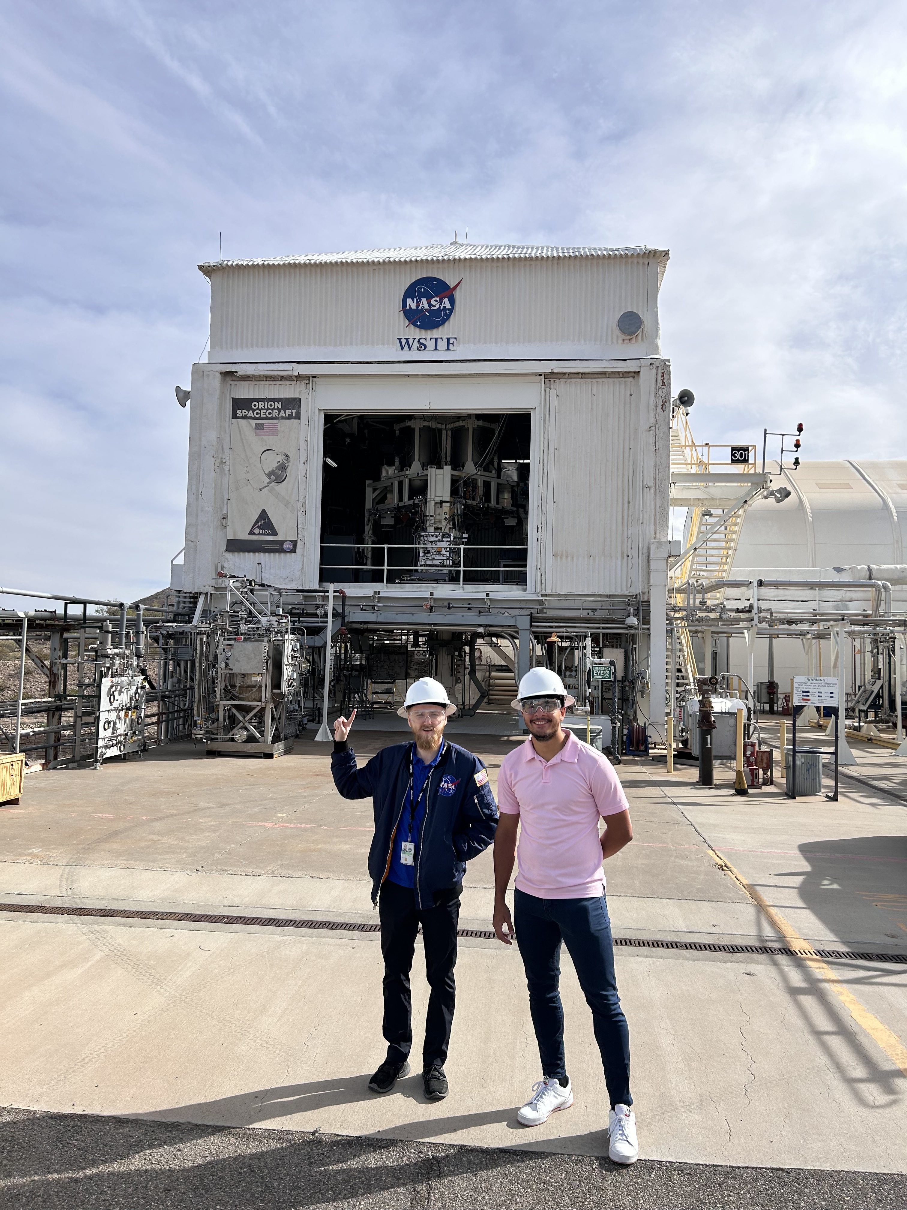
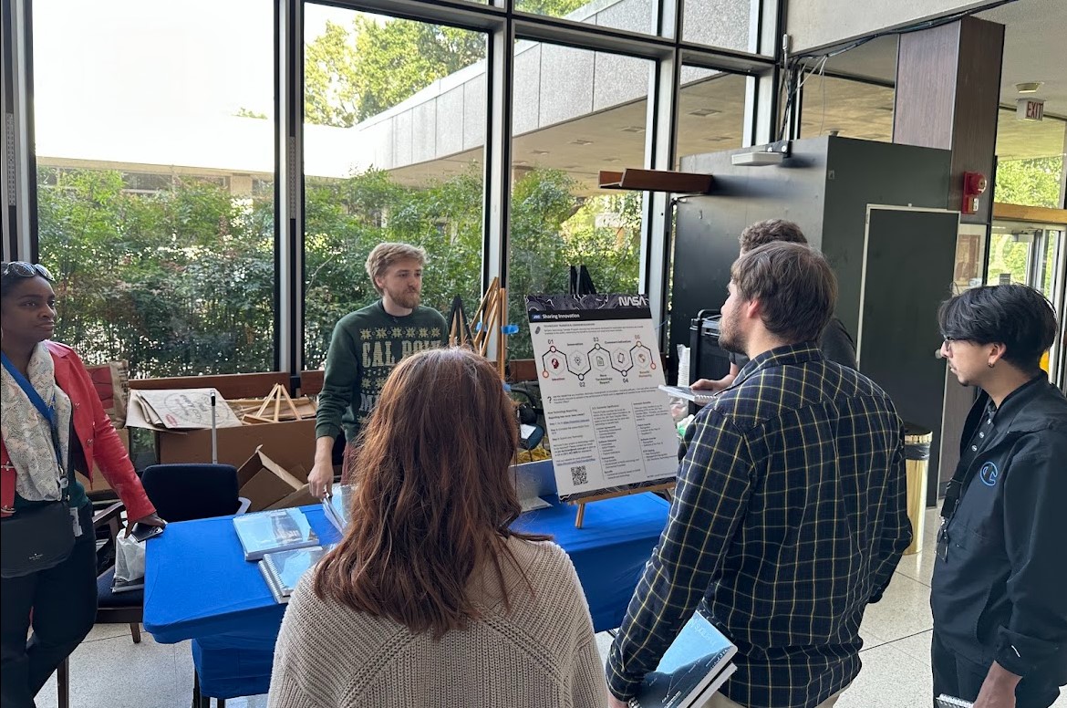
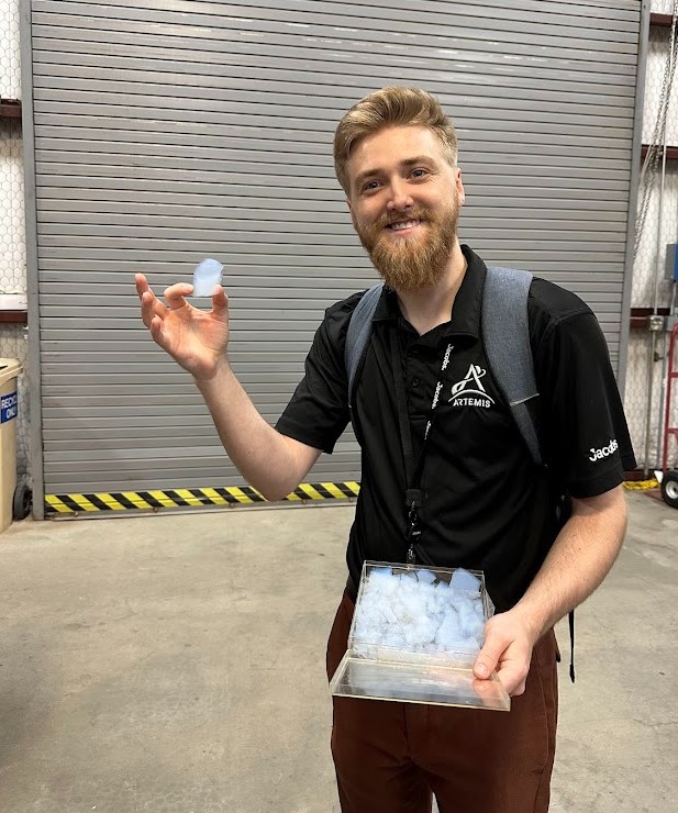
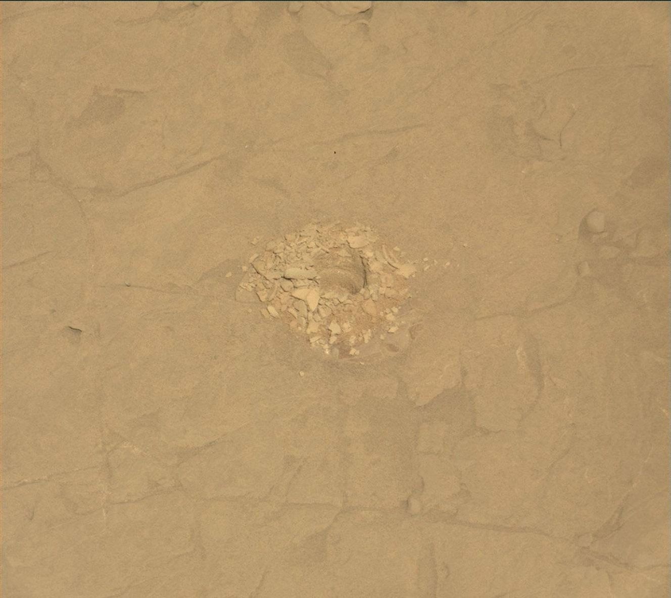
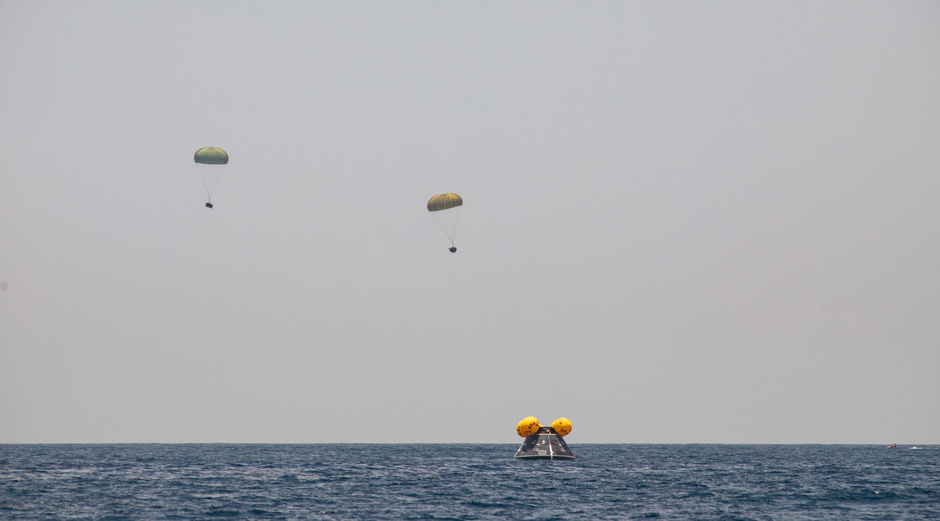
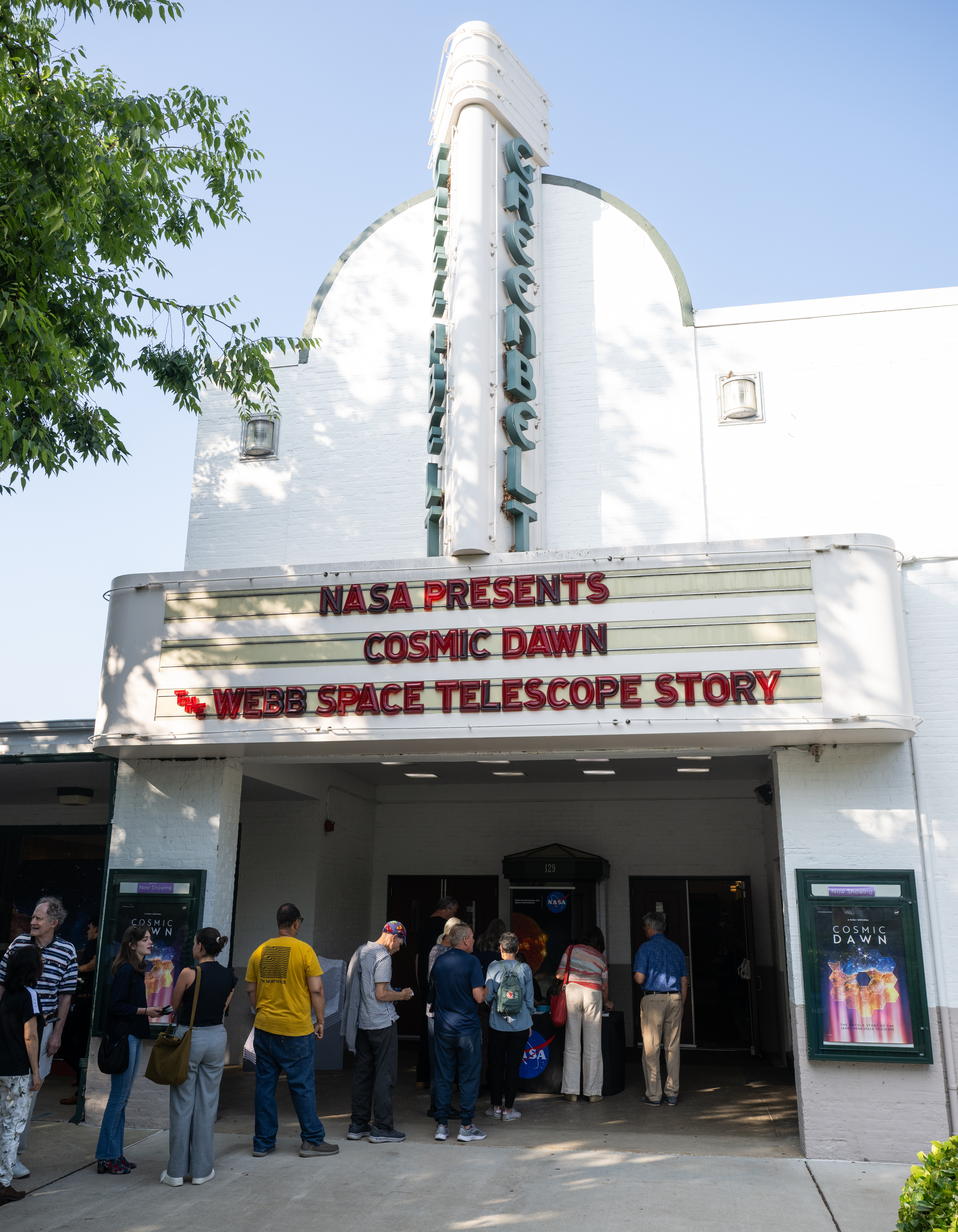
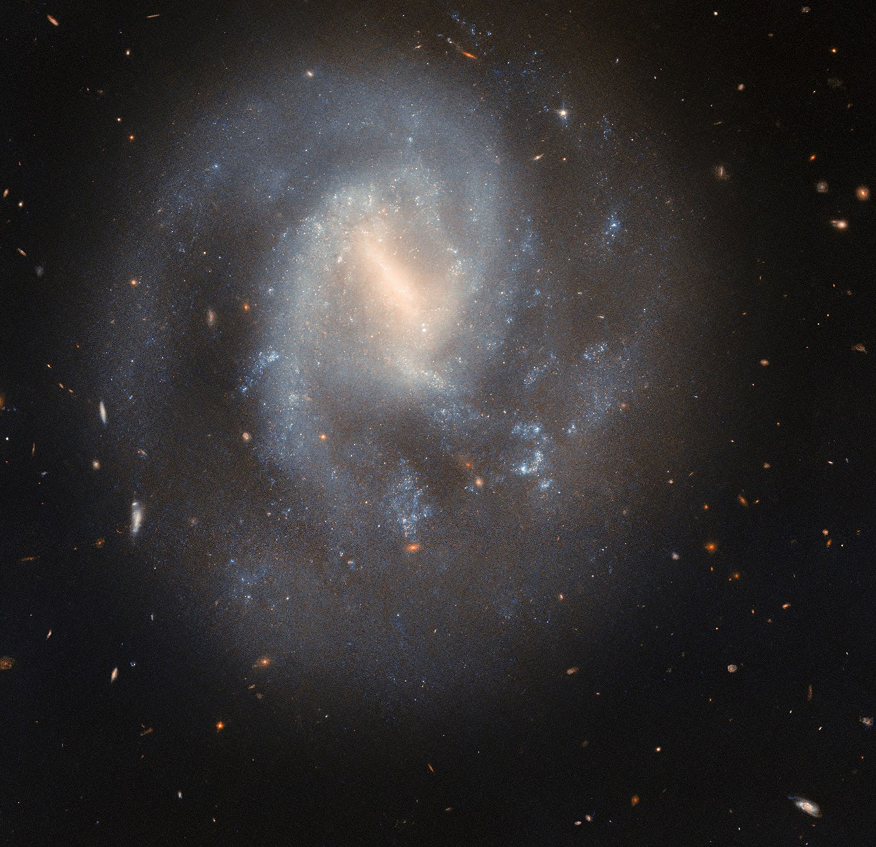
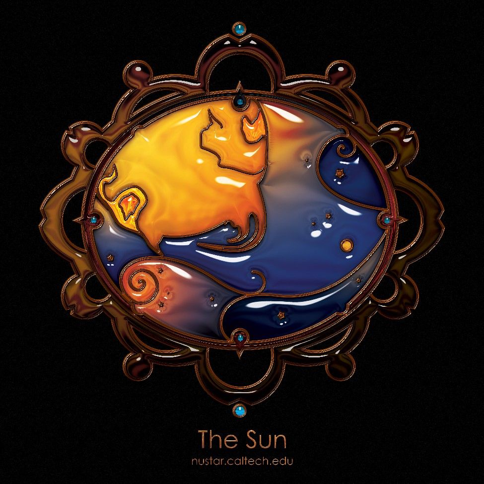
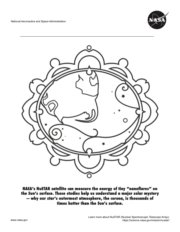
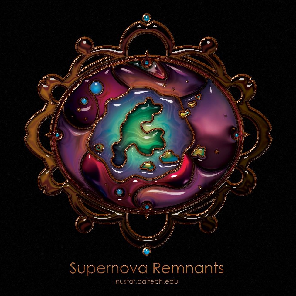
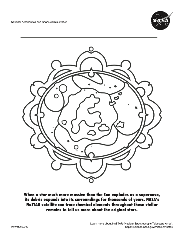
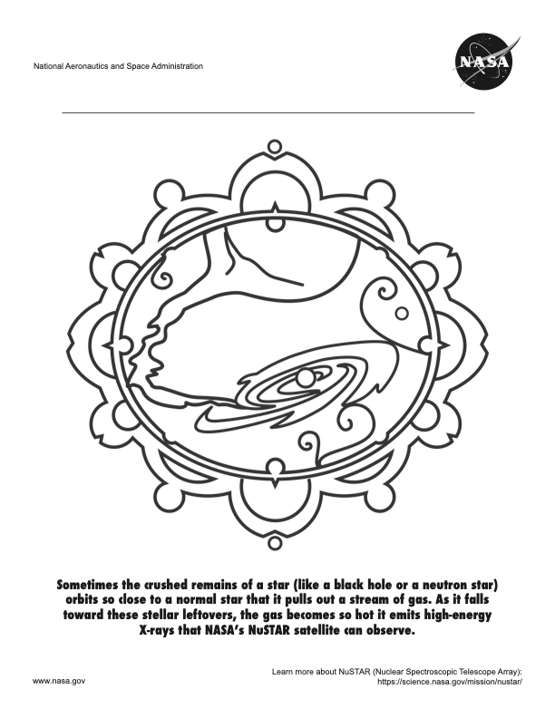
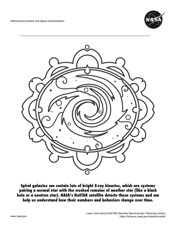
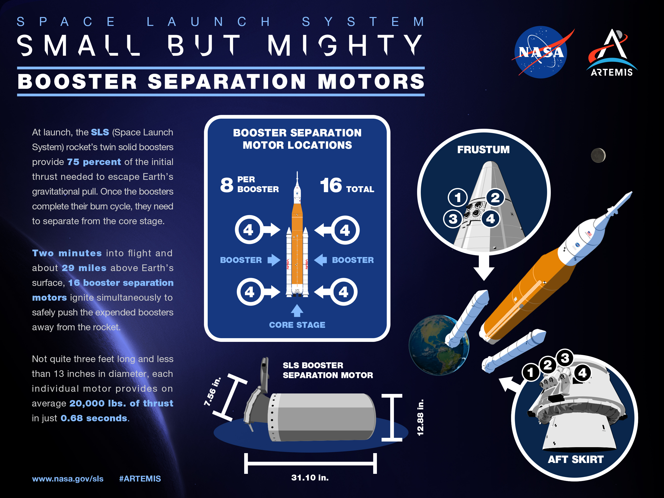
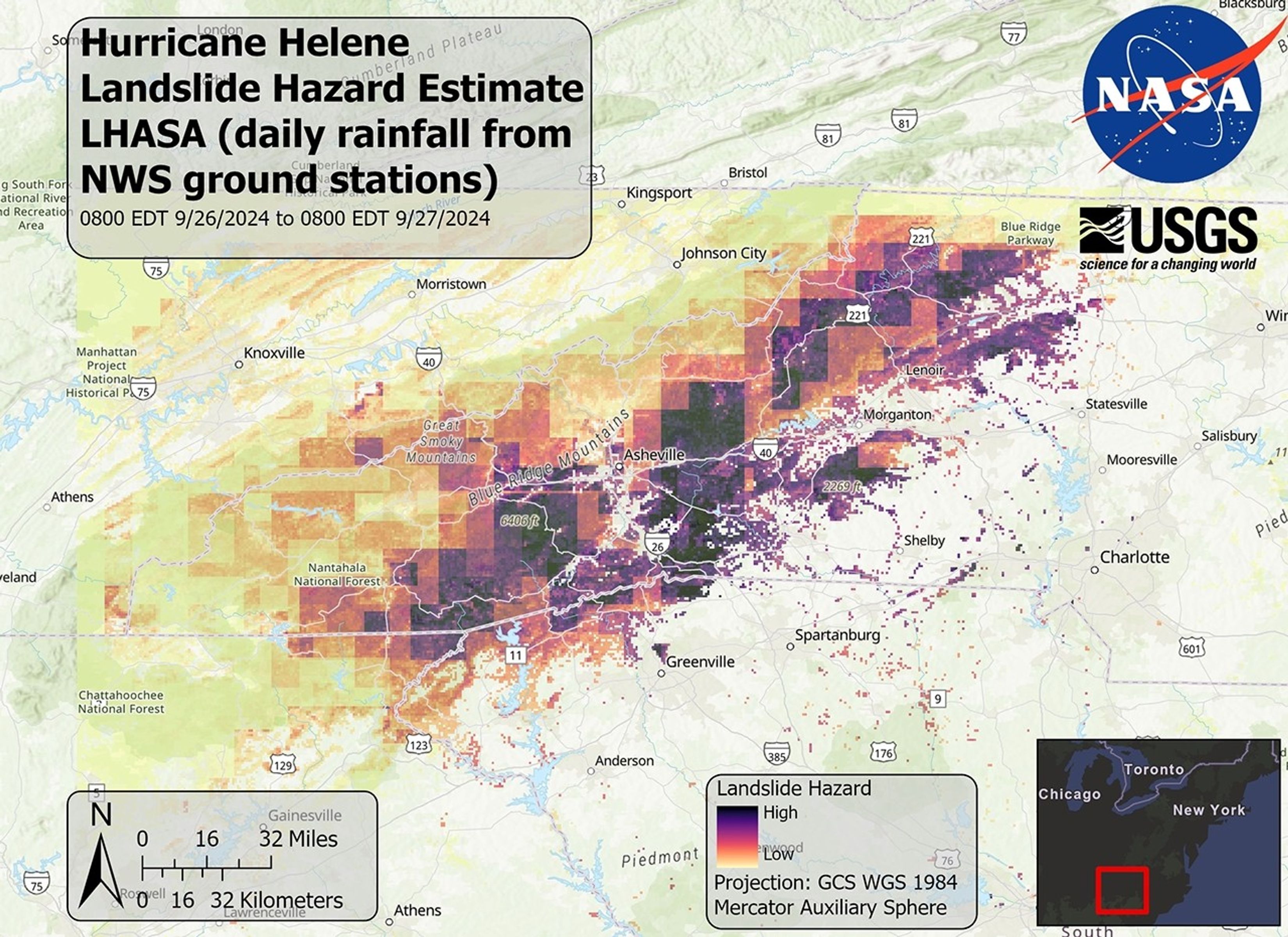
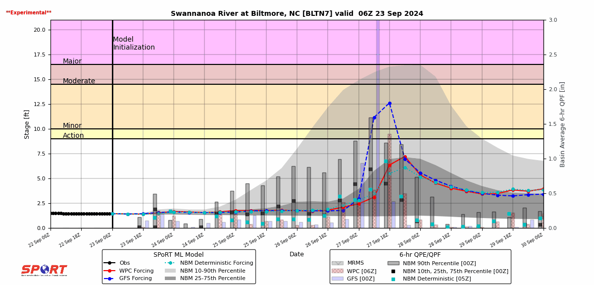
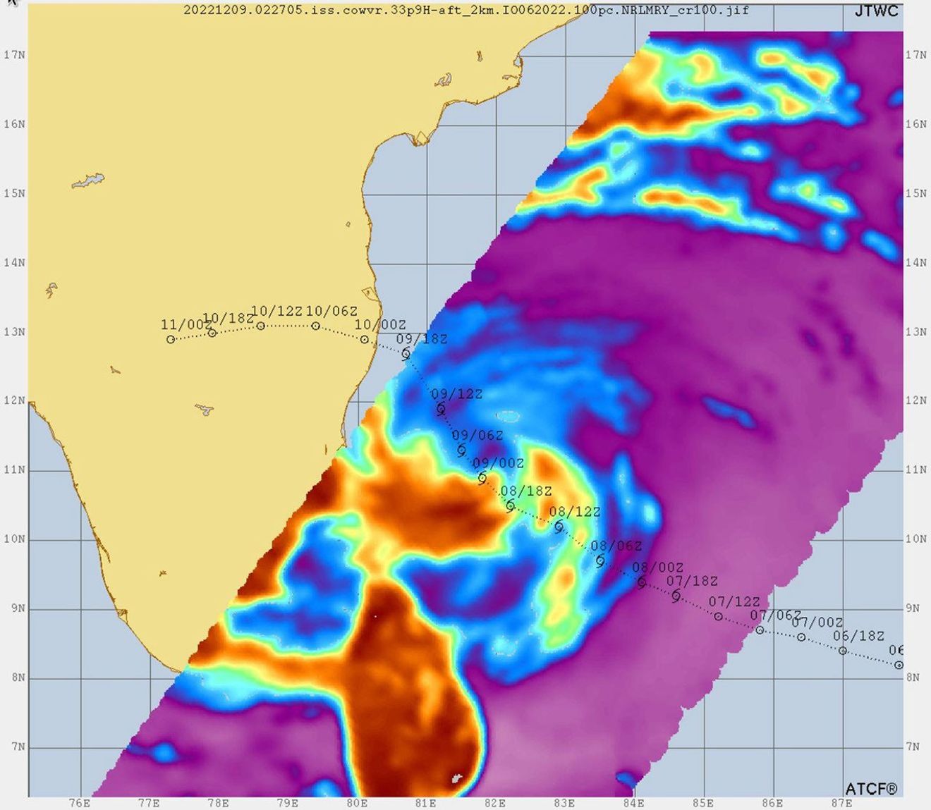
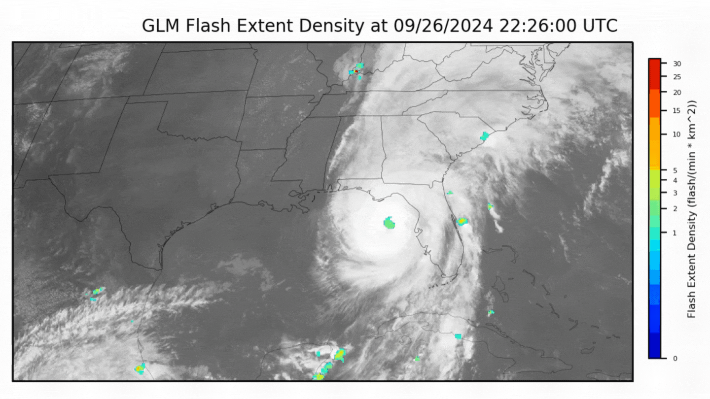
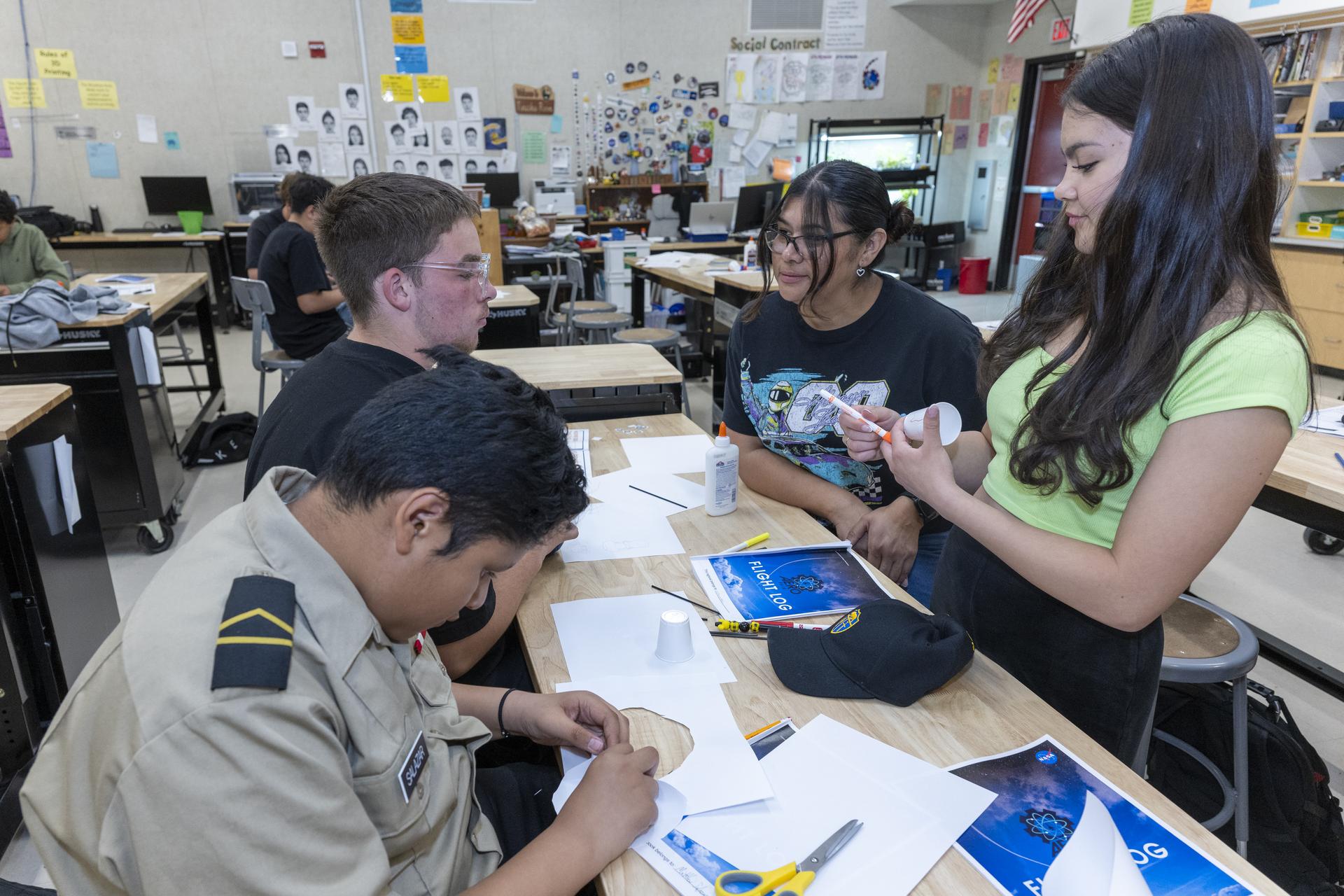
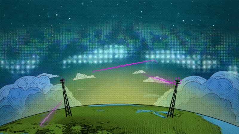
.jpg?w=2048&h=1363&fit=clip&crop=faces%2Cfocalpoint)
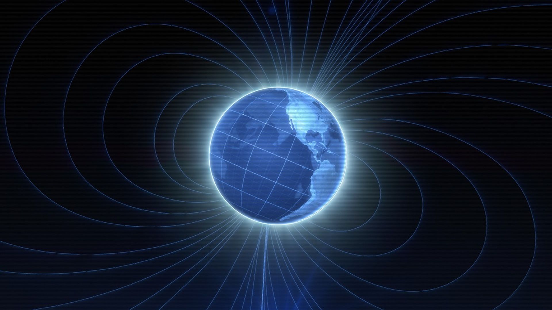
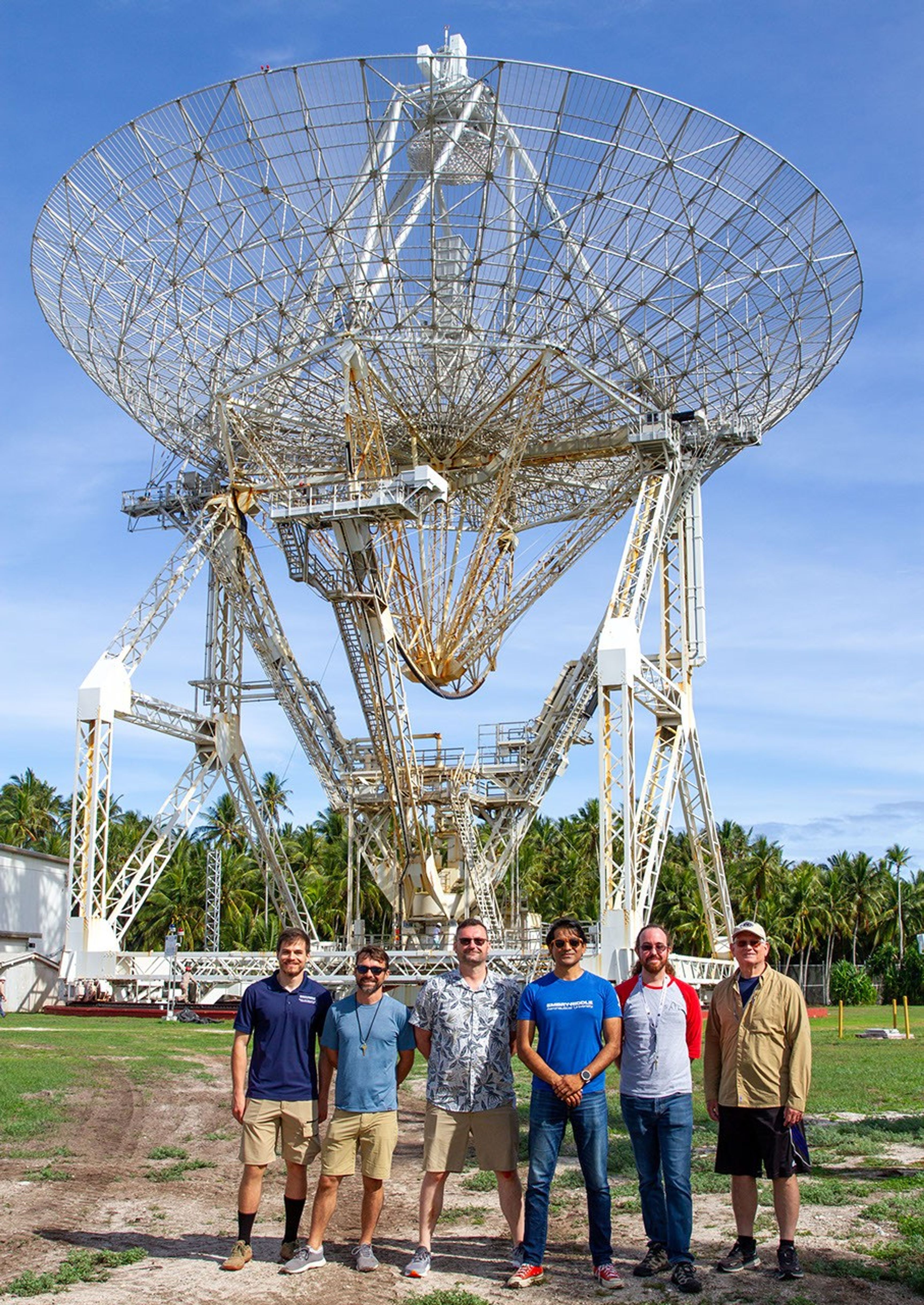
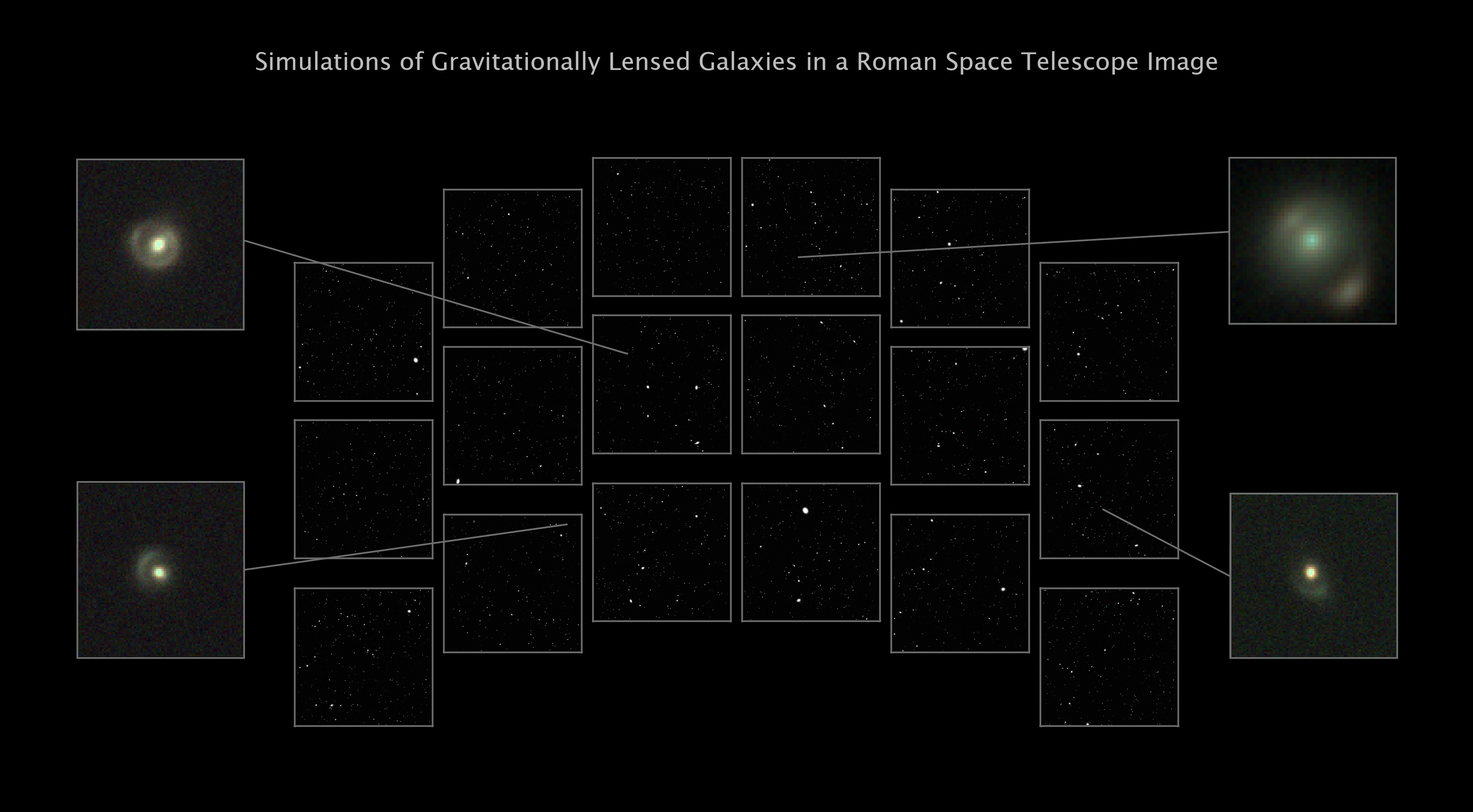
.JPG?w=1024&h=512&fit=clip&crop=faces%2Cfocalpoint)
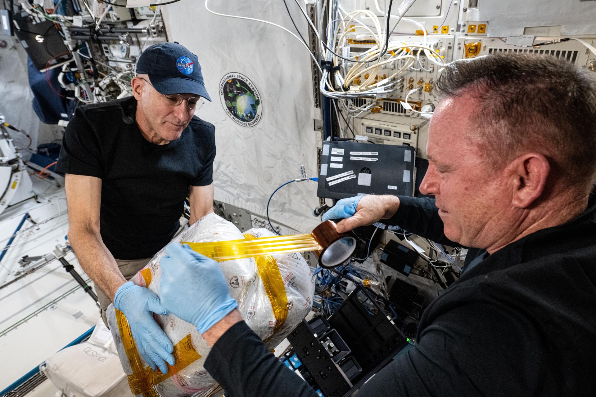
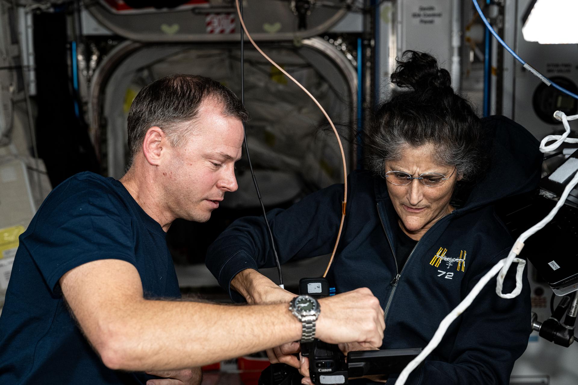
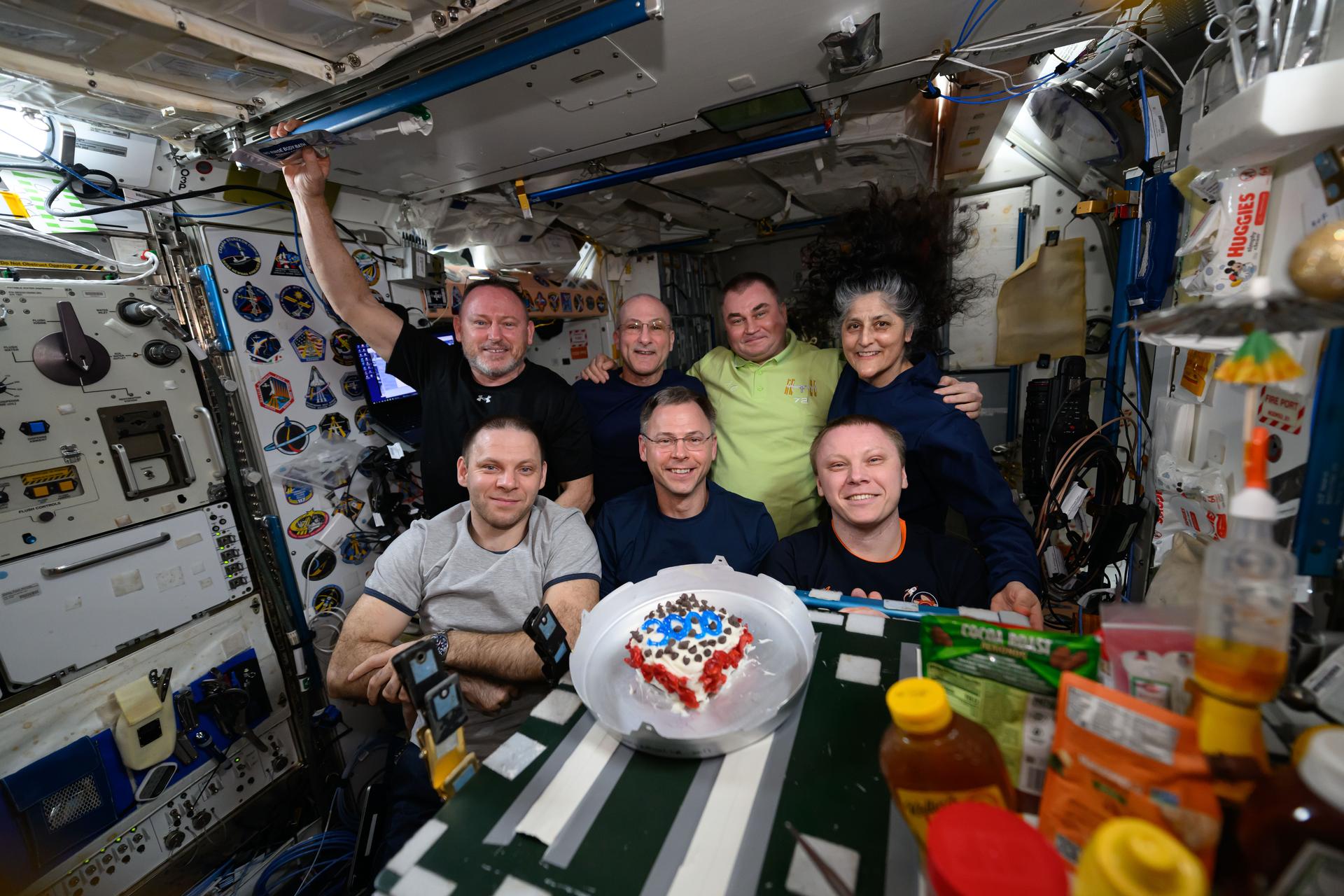
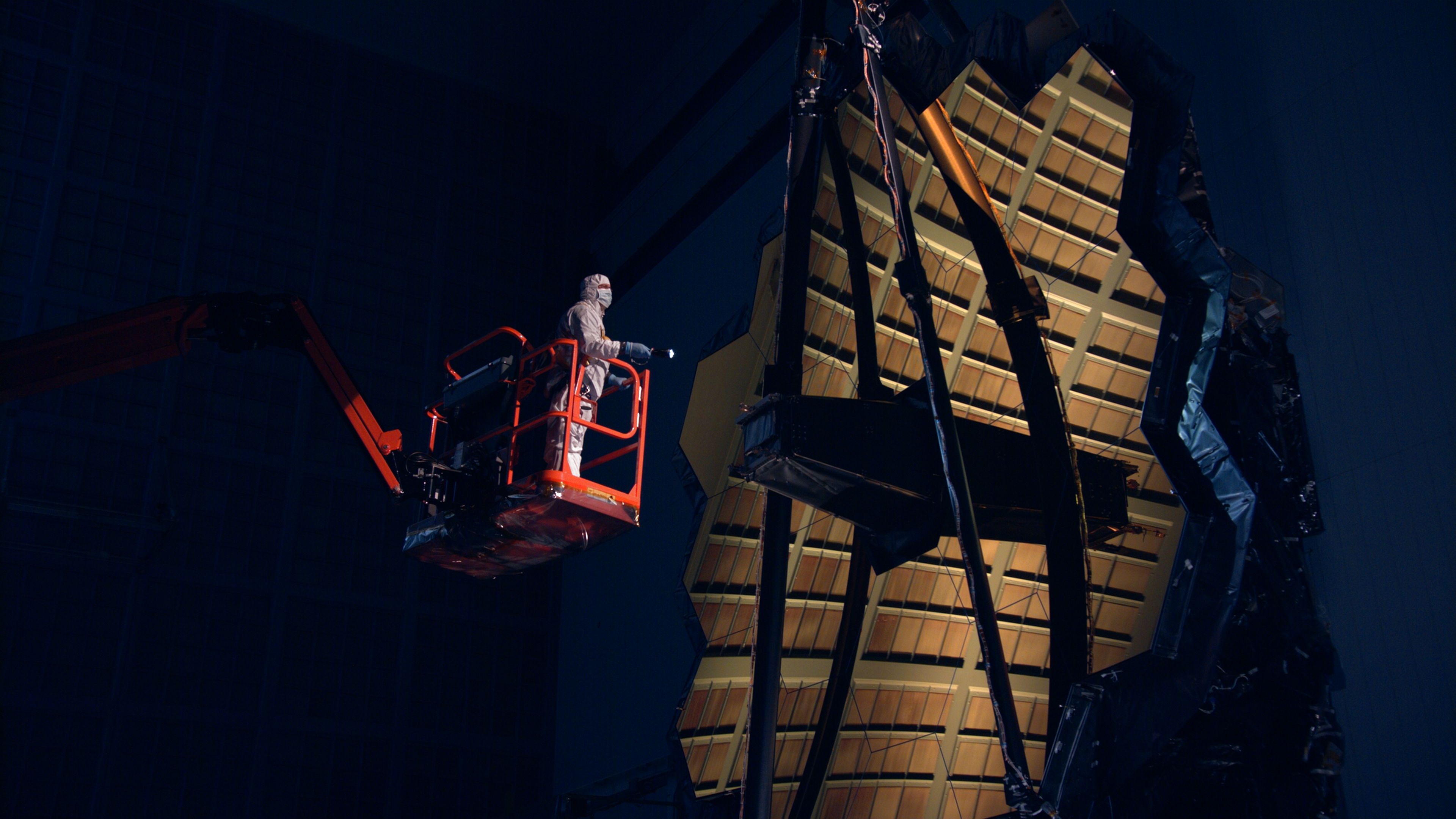
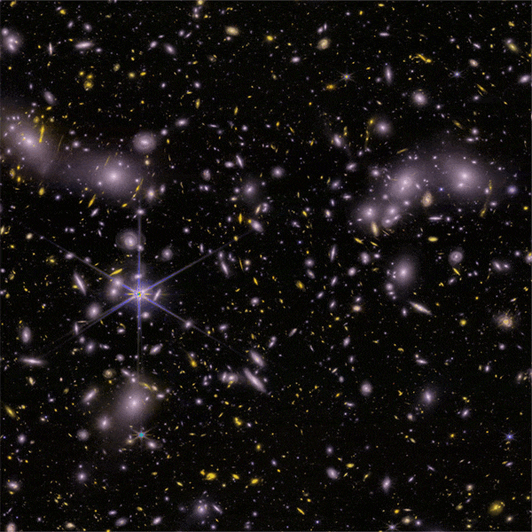
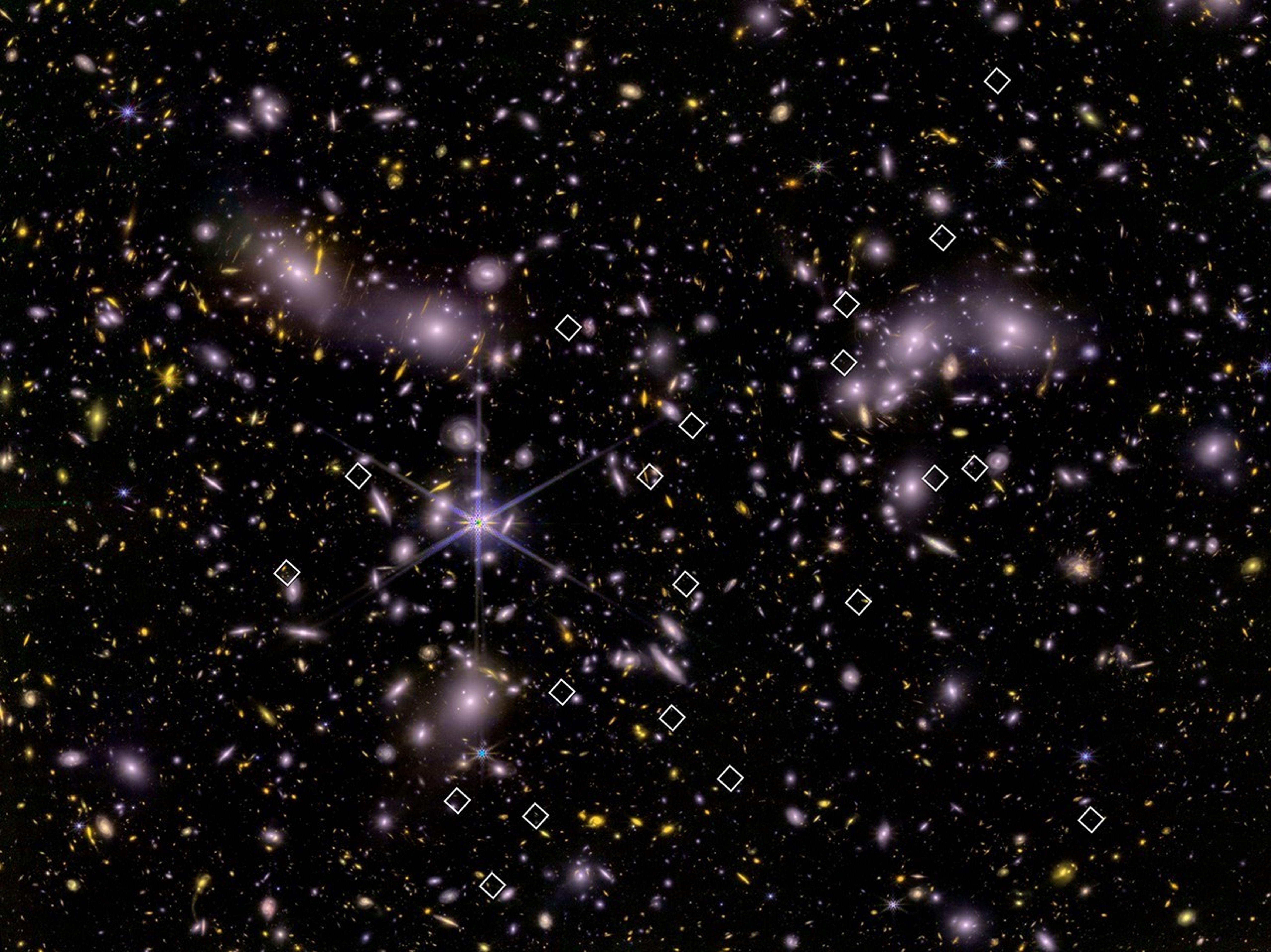
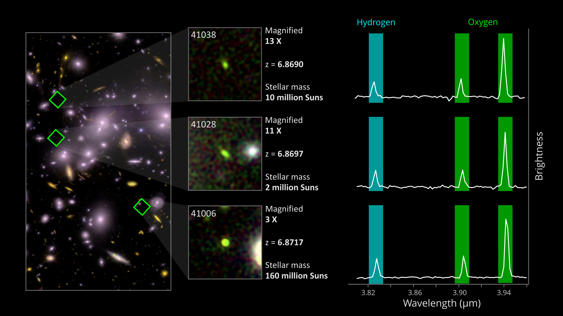