
NASA - Breaking News
NASA Aircraft, Sensor Technology, Aid in Texas Flood Recovery Efforts
3 min read
Preparations for Next Moonwalk Simulations Underway (and Underwater) The high-altitude WB-57 aircraft departed July 8, 2025, from Ellington Field in Houston, Texas, headed to the Texas Hill Country. The aircraft will use the DyNAMITE (Day/Night Airborne Motion Imager for Terrestrial Environments) sensor system to take video mosaics of the area to assist with the emergency response effort. Photo Credit: NASA/Morgan GridleyIn response to recent flooding near Kerrville, Texas, NASA deployed two aircraft to assist state and local authorities in ongoing recovery operations.
The aircraft are part of the response from NASA’s Disasters Response Coordination System, which is activated to support emergency response for the flooding and is working closely with the Texas Division of Emergency Management, the Federal Emergency Management Agency (FEMA), and the humanitarian groups Save the Children and GiveDirectly.
Persistent cloud-cover has made it difficult to obtain clear satellite imagery, so the Disasters Program coordinated with NASA’s Airborne Science Program at NASA’s Johnson Space Flight Center in Houston to conduct a series of flights to gather observations of the impacted regions. NASA is sharing these data directly with emergency response teams to inform their search and rescue efforts and aid decision-making and resource allocation.
The high-altitude WB-57 aircraft operated by NASA Johnson departed from Ellington Field on July 8 to conduct aerial surveys. The aircraft is equipped with the DyNAMITE (Day/Night Airborne Motion Imager for Terrestrial Environments) sensor.
The DyNAMITE sensor views the Guadalupe River and several miles of the surrounding area, providing high-resolution imagery critical to assessing damage and supporting coordination of ground-based recovery efforts. This system enables real-time collection and analysis of data, enhancing situational awareness and accelerating emergency response times.
In addition, the agency’s Uninhabited Aerial Vehicle Synthetic Aperture Radar (UAVSAR) is flying out of NASA’s Armstrong Flight Research Center in Edwards, California, aboard a Gulfstream III. Managed by the agency’s Jet Propulsion Laboratory in Southern California, the UAVSAR team is planning to collect observations over the Guadalupe, San Gabriel, and Colorado river basins Wednesday, Thursday, and Friday. Because UAVSAR can penetrate vegetation to spot water that optical sensors are unable to detect, the team’s goal is to characterize the extent of flooding to help with understanding the amount of damage within communities.
Flights are being coordinated with FEMA, the Texas Division of Emergency Management, and local responders to ensure data is quickly delivered to those making decisions on the ground. Imagery collected will be sent to NASA’s Disaster Response Coordination System.
Additionally, the Disasters Program, which is part of NASA’s Earth Science Division, is working to produce maps and data to assess the location and severity of flooding in the region and damage to buildings and infrastructure. These data are being shared on the NASA Disasters Mapping Portal as they become available.
Citizen science projects result in an overwhelmingly positive impact on the polar tourism experience. That’s…
Article 6 hours ago 3 min read Aaisha Ali: From Marine Biology to the Artemis Control Room Article 2 days ago 4 min read NASA Mission Monitoring Air Quality from Space Extended Article 6 days ago Keep Exploring Discover Related TopicsMissions
Humans in Space
Climate Change
Solar System
Smarter Searching: NASA AI Makes Science Data Easier to Find
6 min read
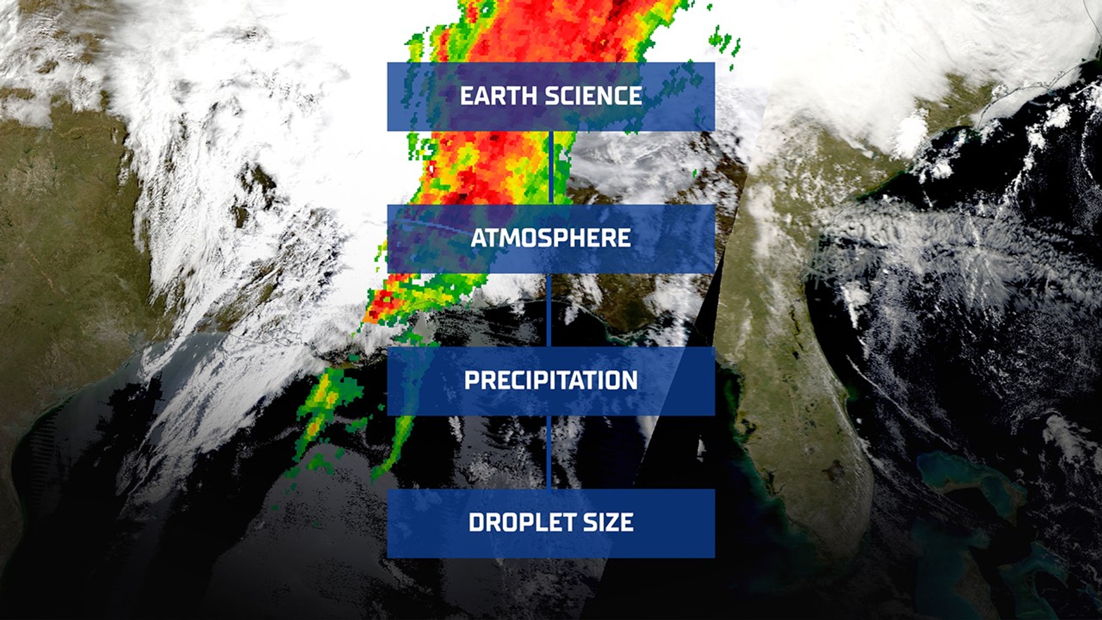
Smarter Searching: NASA AI Makes Science Data Easier to Find Image snapshot taken from NASA Worldview of NASA’s Global Precipitation Measurement (GPM) mission on March 15, 2025 showing heavy rain across the southeastern U.S. with an overlay of the GCMD Keyword Recommender for Earth Science, Atmosphere, Precipitation, Droplet Size. NASA WorldviewImagine shopping for a new pair of running shoes online. If each seller described them differently—one calling them “sneakers,” another “trainers,” and someone else “footwear for exercise”—you’d quickly feel lost in a sea of mismatched terminology. Fortunately, most online stores use standardized categories and filters, so you can click through a simple path: Women’s > Shoes > Running Shoes—and quickly find what you need.
Now, scale that problem to scientific research. Instead of sneakers, think “aerosol optical depth” or “sea surface temperature.” Instead of a handful of retailers, it is thousands of researchers, instruments, and data providers. Without a common language for describing data, finding relevant Earth science datasets would be like trying to locate a needle in a haystack, blindfolded.
That’s why NASA created the Global Change Master Directory (GCMD), a standardized vocabulary that helps scientists tag their datasets in a consistent and searchable way. But as science evolves, so does the challenge of keeping metadata organized and discoverable.
To meet that challenge, NASA’s Office of Data Science and Informatics (ODSI) at the agency’s Marshall Space Flight Center (MSFC) in Huntsville, Alabama, developed the GCMD Keyword Recommender (GKR): a smart tool designed to help data providers and curators assign the right keywords, automatically.
Smarter Tagging, Accelerated DiscoveryThe upgraded GKR model isn’t just a technical improvement; it’s a leap forward in how we organize and access scientific knowledge. By automatically recommending precise, standardized keywords, the model reduces the burden on human curators while ensuring metadata quality remains high. This makes it easier for researchers, students, and the public to find exactly the datasets they need.
It also sets the stage for broader applications. The techniques used in GKR, like applying focal loss to rare-label classification problems and adapting pre-trained transformers to specialized domains, can benefit fields well beyond Earth science.
Metadata MatchmakerThe newly upgraded GKR model tackles a massive challenge in information science known as extreme multi-label classification. That’s a mouthful, but the concept is straightforward: Instead of predicting just one label, the model must choose many, sometimes dozens, from a set of thousands. Each dataset may need to be tagged with multiple, nuanced descriptors pulled from a controlled vocabulary.
Think of it like trying to identify all the animals in a photograph. If there’s just a dog, it’s easy. But if there’s a dog, a bird, a raccoon hiding behind a bush, and a unicorn that only shows up in 0.1% of your training photos, the task becomes far more difficult. That’s what GKR is up against: tagging complex datasets with precision, even when examples of some keywords are scarce.
And the problem is only growing. The new version of GKR now considers more than 3,200 keywords, up from about 430 in its earlier iteration. That’s a sevenfold increase in vocabulary complexity, and a major leap in what the model needs to learn and predict.
To handle this scale, the GKR team didn’t just add more data; they built a more capable model from the ground up. At the heart of the upgrade is INDUS, an advanced language model trained on a staggering 66 billion words drawn from scientific literature across disciplines—Earth science, biological sciences, astronomy, and more.
NASA ODSI’s GCMD Keyword Recommender AI model automatically tags scientific datasets with the help of INDUS, a large language model trained on NASA scientific publications across the disciplines of astrophysics, biological and physical sciences, Earth science, heliophysics, and planetary science. NASA“We’re at the frontier of cutting-edge artificial intelligence and machine learning for science,” said Sajil Awale, a member of the NASA ODSI AI team at MSFC. “This problem domain is interesting, and challenging, because it’s an extreme classification problem where the model needs to differentiate even very similar keywords/tags based on small variations of context. It’s exciting to see how we have leveraged INDUS to build this GKR model because it is designed and trained for scientific domains. There are opportunities to improve INDUS for future uses.”
This means that the new GKR isn’t just guessing based on word similarities; it understands the context in which keywords appear. It’s the difference between a model knowing that “precipitation” might relate to weather versus recognizing when it means a climate variable in satellite data.
And while the older model was trained on only 2,000 metadata records, the new version had access to a much richer dataset of more than 43,000 records from NASA’s Common Metadata Repository. That increased exposure helps the model make more accurate predictions.
The Common Metadata Repository is the backend behind the following data search and discovery services:
- Earthdata Search
- International Data Network
One of the biggest hurdles in a task like this is class imbalance. Some keywords appear frequently; others might show up just a handful of times. Traditional machine learning approaches, like cross-entropy loss, which was used initially to train the model, tend to favor the easy, common labels, and neglect the rare ones.
To solve this, NASA’s team turned to focal loss, a strategy that reduces the model’s attention to obvious examples and shifts focus toward the harder, underrepresented cases.
The result? A model that performs better across the board, especially on the keywords that matter most to specialists searching for niche datasets.
From Metadata to MissionUltimately, science depends not only on collecting data, but on making that data usable and discoverable. The updated GKR tool is a quiet but critical part of that mission. By bringing powerful AI to the task of metadata tagging, it helps ensure that the flood of Earth observation data pouring in from satellites and instruments around the globe doesn’t get lost in translation.
In a world awash with data, tools like GKR help researchers find the signal in the noise and turn information into insight.
Beyond powering GKR, the INDUS large language model is also enabling innovation across other NASA SMD projects. For example, INDUS supports the Science Discovery Engine by helping automate metadata curation and improving the relevancy ranking of search results.The diverse applications reflect INDUS’s growing role as a foundational AI capability for SMD.
The INDUS large language model is funded by the Office of the Chief Science Data Officer within NASA’s Science Mission Directorate at NASA Headquarters in Washington. The Office of the Chief Science Data Officer advances scientific discovery through innovative applications and partnerships in data science, advanced analytics, and artificial intelligence.
Share Details Last Updated Jul 09, 2025 Related Terms Explore More 2 min read Polar Tourists Give Positive Reviews to NASA Citizen Science in AntarcticaArticle
6 hours ago
2 min read Hubble Observations Give “Missing” Globular Cluster Time to Shine
Article
6 days ago
5 min read How NASA’s SPHEREx Mission Will Share Its All-Sky Map With the World
Article
7 days ago
Keep Exploring Discover Related Topics
Missions
Humans in Space
Climate Change
Solar System
Anatomy of a Space Shuttle
This 2001 illustration labels important parts of a space shuttle orbiter. The orbiter was the heart and brains of the space shuttle and served as the crew transport vehicle that carried astronauts to and from space. The space shuttle was comprised of the orbiter, the main engines, the external tank, and the solid rocket boosters. The space shuttle was the world’s first reusable spacecraft and the first spacecraft in history that could carry large satellites both to and from orbit.
Image credit: NASA
“Hubble at 35 Years” Symposium Explores Insights from Hubble’s Past
As Hubble marks three and a half decades of scientific breakthroughs and technical resilience, the “Hubble at 35 Years” symposium offers a platform to reflect on the mission’s historical, operational, and scientific legacy. Hubble’s trajectory—from early challenges to becoming a symbol of American scientific ingenuity—presents valuable lessons in innovation, collaboration, and crisis response. Bringing together scientists, engineers, and historians at NASA Headquarters ensures that this legacy informs current and future mission planning, including operations for the James Webb Space Telescope, Roman Space Telescope, and other next-generation observatories. The symposium not only honors Hubble’s transformative contributions but also reinforces NASA’s commitment to learning from the past to shape a more effective and ambitious future for space science.
Hubble at 35 YearsLessons Learned in Scientific Discovery and NASA Flagship Mission Operations
October 16–17, 2025
James Webb Auditorium, NASA HQ, Washington, D.C.
The story of the Hubble Space Telescope confirms its place as the most transformative and significant astronomical observatory in history. Once called “the eighth wonder of the world” by a former NASA administrator, Hubble’s development since its genesis in the early 1970s and its launch, repair, and ultimate impact since 1990 provide ample opportunity to apply insights from its legacy. Scientists and engineers associated with groundbreaking discoveries have always operated within contexts shaped by forces including the government, private industry, the military, and the public at large. The purpose of this symposium is to explore the insights from Hubble’s past and draw connections that can inform the development of mission work today and for the future.
Contact the Organizer Keep Exploring Discover More Topics From NASAHubble’s 35th Anniversary
Universe
Humans In Space
NASA History
NASA, International Astronauts Answer Questions from Florida Students
Students in Big Pine Key, Florida, will have the chance to have NASA astronauts aboard the International Space Station answer their prerecorded questions.
At 10:05 a.m. EDT on Monday, July 14, NASA astronaut Nicole Ayers and JAXA (Japan Aerospace Exploration Agency) astronaut Takuya Onishi will answer questions submitted by students.
Watch the 20-minute Earth-to-space call on NASA STEM’s YouTube Channel.
The event is hosted by the Seacamp Association of Big Pine Key, Florida, which provides immersive science lessons for youth interested in discovering the sea. The event will be attended by local Monroe County students, as well as national and international campers ages 10-17 years old. The goal of the event is to help students make connections between astronauts training in space and scientists working in the sea.
Media interested in covering the event must RSVP by 5 p.m. EDT, Friday, July 11, to Judy Gregoire at: 305-872-2331 or email at: info@seacamp.org.
For nearly 25 years, astronauts have continuously lived and worked aboard the space station, testing technologies, performing science, and developing skills needed to explore farther from Earth. Astronauts aboard the orbiting laboratory communicate with NASA’s Mission Control Center in Houston 24 hours a day through SCaN’s (Space Communications and Navigation) Near Space Network.
Important research and technology investigations taking place aboard the space station benefit people on Earth and lay the groundwork for other agency missions. As part of NASA’s Artemis campaign, the agency will send astronauts to the Moon to prepare for future human exploration of Mars; inspiring Golden Age explorers and ensuring the United States continues to lead in space exploration and discovery.
See videos of astronauts aboard the space station at:
https://www.nasa.gov/stemonstation
-end-
Gerelle Dodson
Headquarters, Washington
202-358-1600
gerelle.q.dodson@nasa.gov
Sandra Jones
Johnson Space Center, Houston
281-483-5111
sandra.p.jones@nasa.gov
I Am Artemis: Joe Pavicic
Listen to this audio excerpt from Joe Pavicic, Artemis operations project engineer
0:00 / 0:00
Your browser does not support the audio element.Joe Pavicic will never forget when he told the Artemis launch director teams were NO-GO for launch.
Before Artemis I lifted off from NASA’s Kennedy Space Center in Florida in November 2022, the launch team made multiple launch attempts the months prior.
“During a previous Artemis I launch attempt, there was an issue with engine three,” said Pavicic, operations project engineer who worked on the engines console during Artemis I. “One sensor was showing that it wasn’t seeing liquid hydrogen through it. It was showing that it was at ambient temperature.”
And I had to tell the launch director, ‘We can't get there today with the current criteria that we have. My recommendation is a NO-GO.’Joe pavicic
Operations Project Engineer
Prior to engine ignition, launch team controllers must first chill the engines before the cryogenic liquid propellant fuels and lifts the SLS (Space Launch System) rocket and Orion spacecraft into the heavens and onward to the Moon. Chilling the engines ensures the hardware doesn’t get damaged when exposed to the super-cooled liquid hydrogen at -423 degrees Fahrenheit.
NASA/Kim Shiflett“We tried everything we could think of,” Pavicic recalls. “Any procedure we could try, we tried it, and we just never saw those rates that we should have.”
Thus, Pavicic, who is originally from West Palm Beach and studied aerospace engineering at Embry Riddle Aeronautical University in Daytona Beach, Florida, went back to the drawing board with the rest of his team, working days and nights rewriting procedures and learning new lessons about the engines and sensors until they were finally able to get to a successful launch.
“I just remember after I said, 'NO-GO,' I felt like all these people came to watch the launch, all my family, and I'm like, ‘I'm the guy,' but I told myself, ‘I'm not going to be the one to say this for the next launch attempt. I'm going to do what I can to get us there.’joe pavicic
Operations Project Engineer
NASA successfully launched and flew the Artemis I mission and now, Pavicic is working as one of the operations project engineers, continuing to help the launch team develop new launch commit criteria and procedures within the launch countdown ahead of Artemis II, the first crewed Artemis mission, which will send four astronauts around the Moon and back in 10 days next year.
About the AuthorAntonia Jaramillo Share Details Last Updated Jul 09, 2025 Related Terms Explore More 3 min read Aaisha Ali: From Marine Biology to the Artemis Control Room Article 2 days ago 2 min read NASA Announces Winners of 2025 Human Lander Challenge Article 2 weeks ago 4 min read I Am Artemis: Patrick Junen Article 2 weeks ago Keep Exploring Discover More Topics From NASAMissions
Humans in Space
Climate Change
Solar System
Polar Tourists Give Positive Reviews to NASA Citizen Science in Antarctica
2 min read
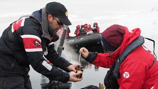
Polar Tourists Give Positive Reviews to NASA Citizen Science in AntarcticaCitizen science projects result in an overwhelmingly positive impact on the polar tourism experience. That’s according to a new paper analyzing participant experiences in the first two years of FjordPhyto, a NASA Citizen Science project..
The FjordPhyto citizen science project invites travelers onboard expedition cruise vessels to gather data and samples during the polar summer season, helping researchers understand changes in microalgae communities in response to melting glaciers. Travelers in Antarctica from November to March help collect phytoplankton and ocean data from polar regions facilitated by trained expedition guides.
The new research found that ninety-seven percent of respondents reported that participating in citizen science enriched their travel experience. The paper provides a first understanding of the impact of citizen science projects on the tourism experience.
“I was worried that I would feel guilty being a tourist in a place as remote and untouched as Antarctica,” said one anonymous FjordPhyto participant. “But being able to learn and be a part of citizen science, whilst constantly being reminded of our environmental responsibilities, made me feel less like just a visitor and more a part of keeping the science culture that Antarctica is known for alive and well.”
For more information and to sign up, visit the FjordPhyto website.
Travelers in Antarctica participate in collecting phytoplankton and ocean data from polar regions facilitated by trained expedition guides. Credit: Mathew Farrell courtesy of Robert Gilmore Share Details Last Updated Jul 09, 2025 Related Terms Explore More 2 min read NASA Citizen Scientists Find New Eclipsing Binary StarsArticle
2 weeks ago
2 min read Live or Fly a Plane in California? Help NASA Measure Ozone Pollution!
Article
2 weeks ago
5 min read NASA Launching Rockets Into Radio-Disrupting Clouds
Article
4 weeks ago
Continuing the Quest for Clays
- Perseverance Home
- Science
- News and Features
- Multimedia
- Mars Missions
- Mars Home
3 min read
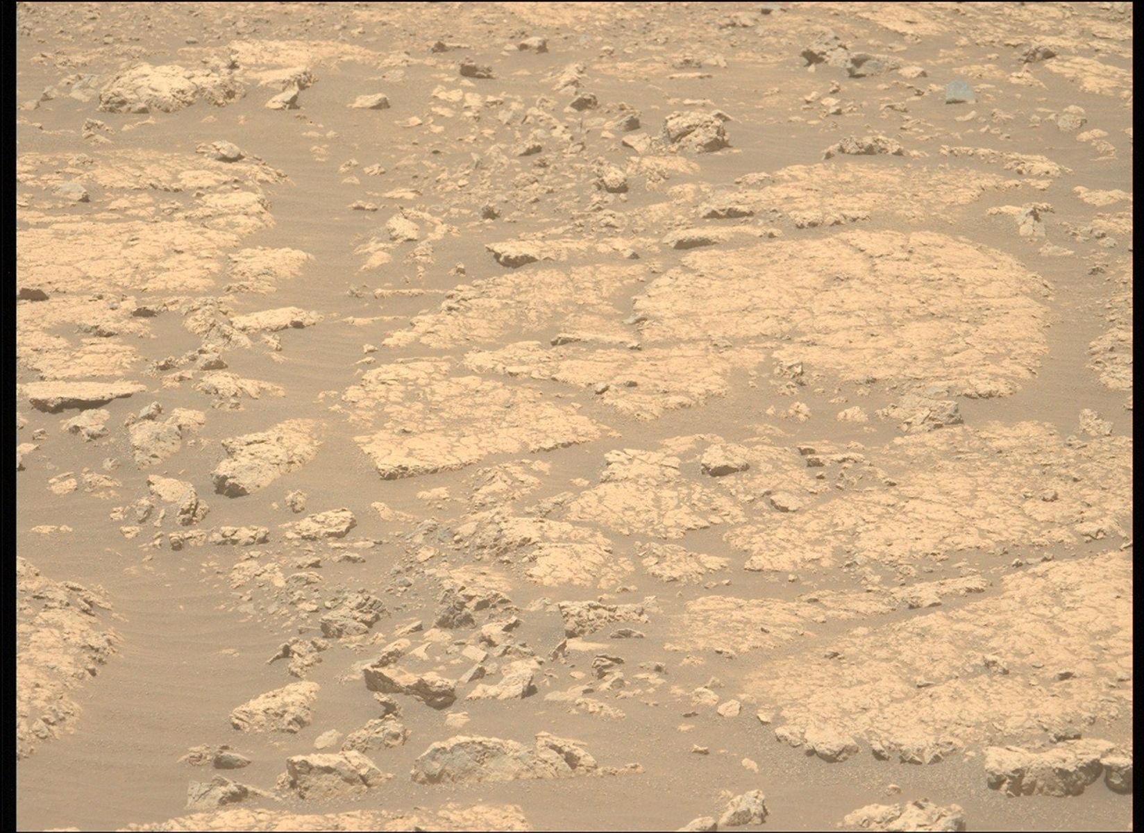
Continuing the Quest for Clays NASA’s Mars Perseverance rover acquired this image showing the target “Jigging Cove,” named by Make-A-Wish participant Madeline, located in the center of the image. Perseverance used its Left Mastcam-Z camera, one of a pair of cameras located high on the rover’s mast, to capture the image on June 27, 2025 (Sol 1547, or Martian day 1,547 of the Mars 2020 mission) at the local mean solar time of 11:26:04. NASA/JPL-Caltech/ASUWritten by Eleanor Moreland, Ph.D. Student Collaborator at Rice University
For the past month and a half, Perseverance has been exploring the Krokodillen plateau in search of clay-bearing rocks. An earlier blog discussed that these rocks could hold clues to Mars’ watery past, and Perseverance has been exploring multiple potential locations to find a suitable target to sample. When a coring target could not be found at the previous outcrop, the Science Team decided to return to the “Main Topsail” locality. In a single drive to this area, Perseverance drove 411.7 meters (1,350.7 feet, or just over a quarter mile) — the longest driving distance ever accomplished by a robotic vehicle on another planet. Go, Percy, go!
Back in the region near “Main Topsail” and “Salmon Point,” the team attempted to abrade and sample the clay-bearing rocks at a few different targets. These rocks, however, are proving very breakable and difficult to sample and abrade. Perseverance has experienced challenging fine-grained rocks before, such as during the fan front campaign inside Jezero crater. In that scenario and this one, the Science and Engineering teams work together diligently to find the highest priority targets and find rocks that could withstand the abrasion and coring processes. In this case, the team has decided to return to the site of a previous abrasion, “Strong Island,” to sample the rock we have already abraded and analyzed. This abrasion showed the strong clay signature the team is looking to sample, and we will make another coring attempt this week.
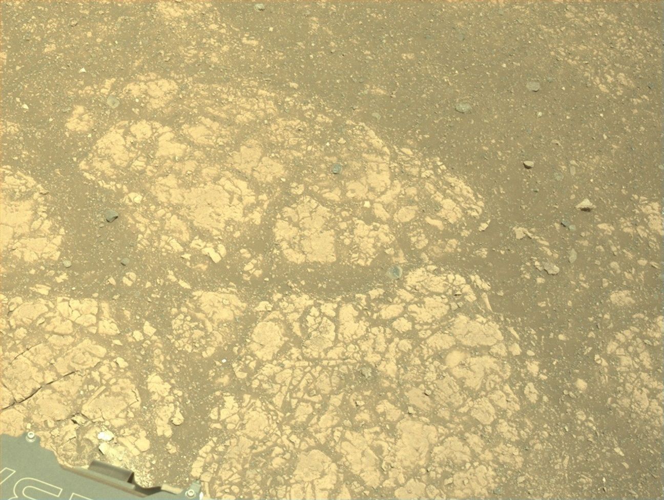
NASA’s Mars Perseverance rover acquired this image of the target “Gallants,” named by Make-A-Wish participant Joshua, located in the lower left quadrant of the image. Perseverance used its onboard Left Navigation Camera (Navcam), which is located high on the rover’s mast and aids in driving, to capture the image on July 1, 2025 (Sol 1551 or Martian day 1,551 of the Mars 2020 mission), at the local mean solar time of 13:10:08. NASA/JPL-CaltechThis past week, the Perseverance team hosted two very special visitors, Madeline and Joshua, and had the unique honor of fulfilling their wishes through the Make-A-Wish foundation. During their visits to JPL, Madeline and Joshua were named honorary Mars 2020 Operations Team Members. They visited the test rovers in the JPL Mars Yard, watched data arrive from the rover with the Perseverance operations team, and attended a rover planning meeting, collaborating with the science and engineering team members on campus. Madeline and Joshua will forever be connected to the Mars 2020 mission, as each selected the name of one of our planning targets. Madeline’s target, “Jigging Cove,” was a target for Mastcam-Z and SuperCam “all techniques” analysis, including LIBS, VISIR, and RMI. Joshua’s selection, “Gallants,” will be used for the next coring target. Carrying forward the resilience shown by Madeline and Joshua, Perseverance will attempt to sample this clay-rich bedrock before continuing the investigation along the Jezero crater rim.
Share Details Last Updated Jul 08, 2025 Related Terms Explore More 2 min read Curiosity Blog, Sols 4589 – 4592: Setting up to explore Volcán Peña BlancaArticle
21 hours ago
2 min read Curiosity Blog, Sol 4588: Ridges and troughs
Article
22 hours ago
2 min read Curiosity Blog, Sols 4586-4587: Straight Drive, Strategic Science
Article
7 days ago
Keep Exploring Discover More Topics From NASA Mars
Mars is the fourth planet from the Sun, and the seventh largest. It’s the only planet we know of inhabited…
All Mars Resources
Explore this collection of Mars images, videos, resources, PDFs, and toolkits. Discover valuable content designed to inform, educate, and inspire,…
Rover Basics
Each robotic explorer sent to the Red Planet has its own unique capabilities driven by science. Many attributes of a…
Mars Exploration: Science Goals
The key to understanding the past, present or future potential for life on Mars can be found in NASA’s four…
Helio Highlights: May 2025
- Home
- Framework for Heliophysics Education
- Resource Database
- About NASA HEAT
- More
3 min read
Helio Highlights: May 2025 3 Min Read Helio Highlights: May 2025 A satellite image showing the extent of the Northern Lights during part of the Mother’s Day 2024 solar storms. Credits:NOAA One year ago, solar storms lit up the night sky. Why?
The Sun is 93 million miles away from Earth, on average. Even though it’s far away, we can still see and feel its effects here. One of the most beautiful effects are the auroras – colorful lights that dance across the sky near the North and South Poles. These are also called the Northern and Southern Lights. They happen when tiny particles from the Sun hit gas molecules in our atmosphere and give off energy.
Sometimes the Sun becomes very active and sends out a lot more energy than normal. When this happens, we can see auroras in places much farther from the poles than normal. In May 2024, around Mother’s Day, the Sun sent powerful solar storms in the direction of Earth. These storms were also called the Gannon Storms, named after Jennifer Gannon, a scientist who studied space weather. The Northern Lights could be seen as far south as Puerto Rico, Hawaii, Mexico, Jamaica, and the Bahamas. The Southern Lights were also visible as far north as South Africa and New Zealand.
Aurora Borealis seen from British Columbia, Canada on May 10, 2024. NASA/Mara Johnson-GrohScientists who study the Sun and its effects on our solar system work in a field called heliophysics. Their studies of the Sun have shown that it goes through cycles of being more active and less active. Each one of these cycles lasts about 11 years, but can be anywhere from 8 to 14 years long. This is called the Solar Cycle.
The middle of each cycle is called Solar Maximum. During this time, the Sun has more dark spots (called sunspots) and creates more space weather events. The big storms in May 2024 happened during the Solar Maximum for Solar Cycle 25.
On May 8 and 9, 2024, an active area on the Sun called AR3664 shot out powerful solar flares and several huge bursts of energy called coronal mass ejections (CMEs). These CMEs headed straight for Earth. The first CME pushed aside the normal solar wind, making a clear path for the others to reach us faster. When all this energy hit our atmosphere, it created auroras much farther from the poles than usual. It was like the Sun gave the auroras a huge power boost!
Eruptions of Solar material into space as seen on May 7 (right) and May 8 (left), 2024. These types of eruptions often come just before a larger Coronal Mass Ejection (CME), including the ones which caused the Mother’s Day solar storms. NASA/SDOAuroras are beautiful to watch, but the space weather that creates them can also cause problems. Space weather can mess up radio signals, power grids, GPS systems, and satellites. During the May 2024 storms, GPS systems used by farmers were disrupted. Many farmers use GPS to guide their self-driving tractors. Since this happened during peak planting season, it may have cost billions of dollars in lost profit.
Because space weather can cause so many problems, scientists at NASA and around the world watch the Sun closely to predict when these events will happen. You can help too! Join local science projects at schools, teach others about the Sun, and help make observations in your area. All of this helps us to learn more about the Sun and how it affects our planet.
Here are some resources to connect you to the Sun and auroras Lesson Plans & Educator Guides Magnetic Mysteries: Sun-Earth InteractionsA 5E lesson for high school students to investigate the question of what causes aurora by using Helioviewer to examine solar activity.
Aurora Research and Heliophysics
Learn about aurora, how they form, and the different phases they go through, as well as heliophysics missions that study them.
How Earth’s Magnetic Field Causes Auroras
A 5E middle school lesson where students explore why our planet has a magnetic field (and other planets don’t) and what it is like.
Interactive Resources Magnetic Earth
Introductory activity where users learn about the magnetic field that surrounds Earth and its role in creating the Northern Lights.
NOAA Aurora
30-Minute Forecast
An interactive aurora map for both hemispheres which allows users to predict the likelihood of auroras at different latitudes.
Webinars and Slide Decks Space Weather
Basics
A slide deck (41 slides) that offers an elementary introduction to the basic features of space weather and its interactions with Earth’s magnetosphere and various technologies.
Stellar Duo
NASA’s Hubble Space Telescope captured a bright variable star, V 372 Orionis, and its companion in this festive image in this image released on Jan. 27, 2023. The pair lie in the Orion Nebula, a colossal region of star formation roughly 1,450 light-years from Earth.
V 372 Orionis is a particular type of variable star known as an Orion Variable. These young stars experience some tempestuous moods and growing pains, which are visible to astronomers as irregular variations in luminosity. Orion Variables are often associated with diffuse nebulae, and V 372 Orionis is no exception; the patchy gas and dust of the Orion Nebula pervade this scene.
Text credit: European Space Agency (ESA)
Image credit: ESA/Hubble & NASA, J. Bally, M. Robberto
Curiosity Blog, Sols 4589 – 4592: Setting up to explore Volcán Peña Blanca
- Curiosity Home
- Science
- News and Features
- Multimedia
- Mars Missions
- Mars Home
Written by Abigail Fraeman, Deputy Project Scientist at NASA’s Jet Propulsion Laboratory
Earth planning date: Thursday, July 3, 2025
The team was delighted this morning to learn that Wednesday’s drive had completed flawlessly, placing us in a stable position facing a ~3 foot high ridge located ~35 feet away. This ridge is the eastern edge of a feature the team has informally named “Volcán Peña Blanca.” This feature certainly looked intriguing in orbital images, but once we saw Curiosity’s pictures of it from the ground, we decided it was cool enough to spend the time to investigate it closer. The images from the ground show a lot more detail than is visible in orbit, including clear sedimentary structures exposed along the ridge face which could provide important clues about how the rocks in the boxwork-bearing terrain were initially deposited – dunes? Rivers? Lakes? The team picked their favorite spot to approach the ridge and take a closer look during Wednesday’s planning, so Curiosity made a sharp right turn to take us in that direction. Using today’s images, we refined our plan for the exact location to approach and planned a drive to take us there, setting us up for contact science on Monday.
We had the opportunity to plan four sols today, to cover the U.S. 4th of July holiday weekend, so there was lots of time for activities besides the drive. Curiosity is currently sitting right in front of some light toned rocks, including one we gave the evocative name “Huellas de Dinosaurios.” It’s extremely unlikely we’ll see dinosaur footprints in the rock, but we will get the chance to investigate it with APXS, MAHLI, and ChemCam. We also have a pair of ChemCam only targets on a more typical bedrock target named “Amboro” and some pebbles named “Tunari.” Mastcam will take a high resolution of mosaic covering Volcán Peña Blanca, some nearby rocks named “Laguna Verde,” a small light colored rock named “Suruto,” and various patterns in the ground. Two ChemCam RMI mosaics of features in the distant Mishe Mokwa face and environment monitoring activities round out the plan.
For more Curiosity blog posts, visit MSL Mission Updates
Learn more about Curiosity’s science instruments
Explore More 2 min read Curiosity Blog, Sol 4588: Ridges and troughs
Article
2 hours ago
2 min read Curiosity Blog, Sols 4586-4587: Straight Drive, Strategic Science
Article
6 days ago
3 min read An Update From the 2025 Mars 2020 Science Team Meeting
Article
6 days ago
Keep Exploring Discover More Topics From NASA
Mars
Mars Resources
Explore this page for a curated collection of Mars resources.
Rover Basics
Each robotic explorer sent to the Red Planet has its own unique capabilities driven by science. Many attributes of a…
Mars Exploration: Science Goals
The key to understanding the past, present or future potential for life on Mars can be found in NASA’s four…
Curiosity Blog, Sol 4588: Ridges and troughs
- Curiosity Home
- Science
- News and Features
- Multimedia
- Mars Missions
- Mars Home
Written by Lucy Thompson, APXS Collaborator and Senior Research Scientist at the University of New Brunswick, Canada
Earth planning date: Wednesday, July 2, 2025
As we traverse the boxwork terrain, we are encountering a series of more resistant ridges/bedrock patches, and areas that are more rubbly and tend to form lower relief polygonal or trough-like features. We came into planning this morning in one of the trough-like features after another successful drive. The science team is interested in determining why we see these different geomorphological and erosional expressions. Is the rock that comprises the more resistant ridges and patches a different composition to the rock in the troughs and low relief areas? How do the rocks vary texturally? Might the resistant bedrock be an indicator of what we will encounter when we reach the large boxworks that we are driving towards?
We managed to find a large enough area of rock to safely brush (target – “Guapay”), after which we will place APXS and MAHLI to determine the composition and texture. ChemCam will also analyze a different rock target, “Taltal” for chemistry and texture, and we will also acquire an accompanying Mastcam documentation image. The resistant ridge that we are planning to drive towards (“Volcan Pena Blanca”) and eventually investigate will be captured in a Mastcam mosaic. ChemCam will utilize their long-distance imaging capabilities to image the “Mishe Mokwa” butte off to the southeast of our current location, which likely contains bedrock layers that we will eventually pass through as we continue our climb up Mount Sharp.
After a planned drive, taking us closer to the “Volcan Pena Blanca” ridge, MARDI will image the new terrain beneath the wheels, before we execute some atmospheric observations. Mastcam will make a tau observation to monitor dust in the atmosphere and Navcam will acquire a zenith movie. Standard DAN, RAD and REMS activities round out the plan.
For more Curiosity blog posts, visit MSL Mission Updates
Learn more about Curiosity’s science instruments
Explore More 2 min read Curiosity Blog, Sols 4589 – 4592: Setting up to explore Volcán Peña Blanca
Article
44 minutes ago
2 min read Curiosity Blog, Sols 4586-4587: Straight Drive, Strategic Science
Article
6 days ago
3 min read An Update From the 2025 Mars 2020 Science Team Meeting
Article
6 days ago
Keep Exploring Discover More Topics From NASA
Mars
Mars Resources
Explore this page for a curated collection of Mars resources.
Rover Basics
Each robotic explorer sent to the Red Planet has its own unique capabilities driven by science. Many attributes of a…
Mars Exploration: Science Goals
The key to understanding the past, present or future potential for life on Mars can be found in NASA’s four…
Working in Space
In this May 23, 2025, image, NASA astronaut Jonny Kim works inside the SpaceX Dragon cargo spacecraft completing cargo operations before it undocked from the International Space Station’s Harmony module several hours later. Kim launched to the International Space Station on April 8, 2025; this is his first mission.
See what Kim and other space station crew do aboard the orbital lab.
Image credit: NASA; JAXA (Japan Aerospace Exploration Agency)/Takuya Onishi
NASA’s Hubble and Webb Telescopes Reveal Two Faces of a Star Cluster Duo
- Hubble Home
- Overview
- Impact & Benefits
- Science
- Observatory
- Team
- Multimedia
- News
- More
3 min read
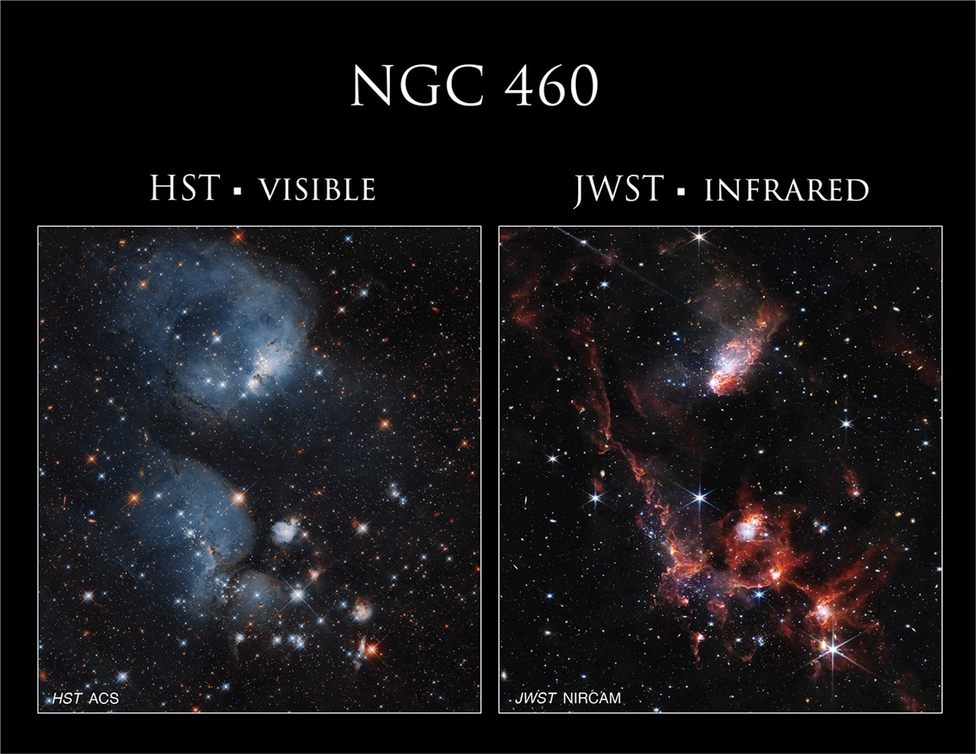
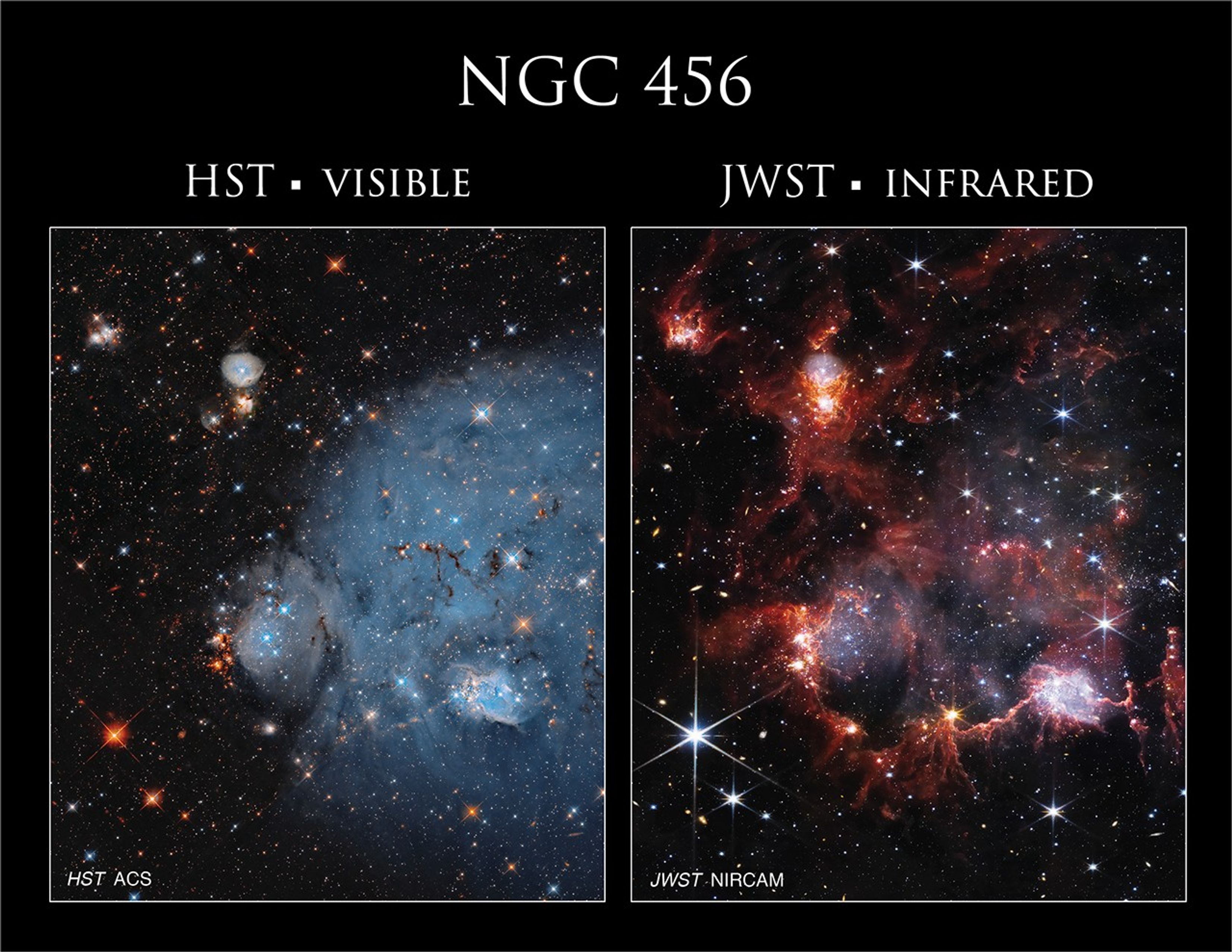
NASA’s Hubble and Webb Telescopes Reveal Two Faces of a Star Cluster Duo A vast network of stars, gas, and dust is strung among a duo of star clusters in this combined image from NASA’s Hubble and Webb space telescopes. Open clusters NGC 460 and NGC 456 reside in the Small Magellanic Cloud, a dwarf galaxy orbiting the Milky Way. This highly detailed 527 megapixel mosaic consists of 12 overlapping observations and includes both visible and infrared wavelengths. To view some of its incredible detail, download the 40.1 MB file and zoom in. NASA, ESA, and C. Lindberg (The Johns Hopkins University); Processing: Gladys Kober (NASA/Catholic University of America)Download this image
A riotous expanse of gas, dust, and stars stake out the dazzling territory of a duo of star clusters in this combined image from NASA’s Hubble and Webb space telescopes.
Open clusters NGC 460 and NGC 456 reside in the Small Magellanic Cloud, a dwarf galaxy orbiting the Milky Way. Open clusters consist of anywhere from a few dozen to a few thousand young stars loosely bound together by gravity. These particular clusters are part of an extensive complex of star clusters and nebulae that are likely linked to one another. As clouds of gas collapse, stars are born. These young, hot stars expel intense stellar winds that shape the nebulae around them, carving out the clouds and triggering other collapses, which in turn give rise to more stars.
In these images, Hubble’s view captures the glowing, ionized gas as stellar radiation blows “bubbles” in the clouds of gas and dust (blue), while Webb’s infrared vision highlights the clumps and delicate filamentary structures of dust (red). In Hubble images, dust is often seen silhouetted against and blocking light, but in Webb’s view, the dust – warmed by starlight – shines with its own infrared glow. This mixture of gas and dust between the universe’s stars is known as the interstellar medium.
Hubble (ACS) Webb (NIRCAM)
This Hubble image shows a duo of open clusters, NGC 460 and NGC 456. The nebulae’s glowing gas, ionized by the radiation of nearby stars, is distinct in Hubble’s view. NASA, ESA, and C. Lindberg (The Johns Hopkins University); Processing: Gladys Kober (NASA/Catholic University of America)
In Webb’s infrared view of open clusters NGC 460 and NGC 456, dusty areas are visible as bright structures glowing red. Many background galaxies are visible, their infrared light passing through the region’s obscuring clouds of gas and dust. NASA, ESA, and C. Lindberg (The Johns Hopkins University); Processing: Gladys Kober (NASA/Catholic University of America) Hubble (ACS)Webb (NIRCAM)
This Hubble image shows a duo of open clusters, NGC 460 and NGC 456. The nebulae’s glowing gas, ionized by the radiation of nearby stars, is distinct in Hubble’s view. NASA, ESA, and C. Lindberg (The Johns Hopkins University); Processing: Gladys Kober (NASA/Catholic University of America) In Webb’s infrared view of open clusters NGC 460 and NGC 456, dusty areas are visible as bright structures glowing red. Many background galaxies are visible, their infrared light passing through the region’s obscuring clouds of gas and dust. NASA, ESA, and C. Lindberg (The Johns Hopkins University); Processing: Gladys Kober (NASA/Catholic University of America)
Hubble (ACS)
Webb (NIRCAM)
Hubble and Webb view a duo of open star clusters
CurtainToggle2-Up
Image Details
Slide to switch between Hubble and Web images. Hubble’s view captures visible light and some infrared wavelengths, while Webb’s view is exclusively infrared. The nebulae’s glowing gas, ionized by the radiation of nearby stars, is distinct in Hubble’s view. Dusty areas that appear dark in the Hubble image are visible as bright structures in the Webb image, and more background galaxies are visible since infrared light from fainter and farther galaxies can pass through the obscuring clouds of gas and dust.
Downloads
Hubble
JPEG
(47 MB)
Webb
JPEG
(35 MB)
The nodules visible in these images are scenes of active star formation, with stars ranging from just one to 10 million years old. In contrast, our Sun is 4.5 billion years old. The region that holds these clusters, known as the N83-84-85 complex, is home to multiple, rare O-type stars, hot and extremely massive stars that burn hydrogen like our Sun. Astronomers estimate there are only around 20,000 O-type stars among the approximately 400 billion stars in the Milky Way.
Clouds of ionized gas dominate open cluster NGC 460 in the Hubble image (left), while tendrils of dust are on display in the Webb image (right). Together, the two images provide a more comprehensive look at the region. NASA, ESA, and C. Lindberg (The Johns Hopkins University); Processing: Gladys Kober (NASA/Catholic University of America) The Hubble image of NGC 456 (left) shows a puffy, bluish cloud of ionized gas, while the Webb image (right) displays the same cluster’s cavern-like outline of dust. NASA, ESA, and C. Lindberg (The Johns Hopkins University); Processing: Gladys Kober (NASA/Catholic University of America)The Small Magellanic Cloud is of great interest to researchers because it is less enriched in metals than the Milky Way. Astronomers call all elements heavier than hydrogen and helium – that is, with more than two protons in the atom’s nucleus – “metals.” This state mimics conditions in the early universe, so the Small Magellanic Cloud provides a relatively nearby laboratory to explore theories about star formation and the interstellar medium at early stages of cosmic history. With these observations of NGC 460 and NGC 456, researchers intend to study how gas flows in the region converge or divide; refine the collision history between the Small Magellanic Cloud and its fellow dwarf galaxy, the Large Magellanic Cloud; examine how bursts of star formation occur in such gravitational interactions between galaxies; and better understand the interstellar medium.
Explore MoreHubble’s Star Clusters
Exploring the Birth of Stars
Hubble’s Nebulae
Facebook logo @NASAHubble @NASAHubble Instagram logo @NASAHubble
Media Contact:
Claire Andreoli
NASA’s Goddard Space Flight Center, Greenbelt, MD
claire.andreoli@nasa.gov
Since its 1990 launch, the Hubble Space Telescope has changed our fundamental understanding of the universe.
Hubble’s Cosmic Adventure
Hubble’s Night Sky Challenge
Hubble’s 35th Anniversary
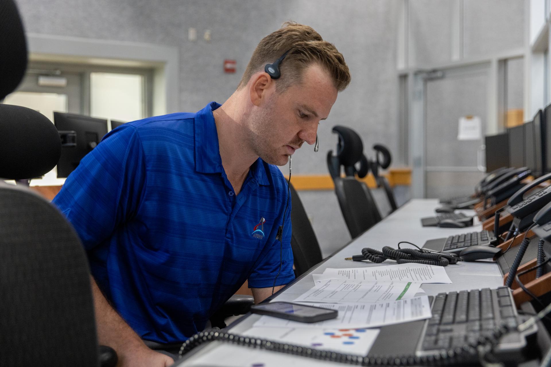
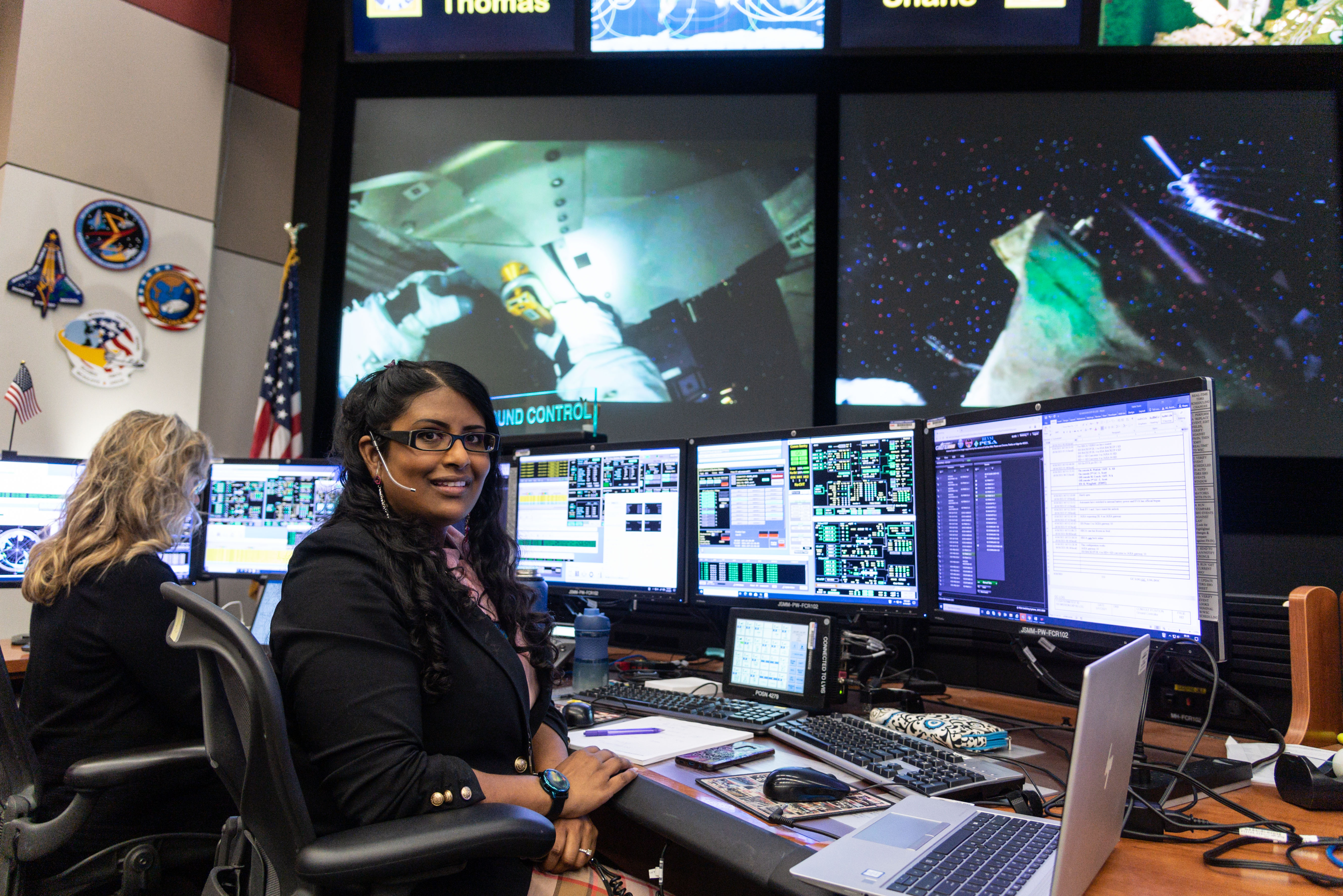
Aaisha Ali: From Marine Biology to the Artemis Control Room
As humanity prepares to return to the lunar surface, Aaisha Ali is behind the scenes ensuring mission readiness for astronauts set to orbit the Moon during Artemis II.
Ali is the Artemis ground control flight lead at NASA’s Johnson Space Center in Houston. She makes sure her team has the resources needed for the next giant leap to the Moon and beyond.
Aaisha Ali on console in the International Space Station Flight Control Room at NASA’s Johnson Space Center in Houston. NASA/Robert Markowitz My passion has always been science. I started by exploring the ocean, and now I get to help explore the stars.Aaisha Ali
Artemis Ground Control Flight Lead
Ali received a bachelor’s degree in biology from Texas A&M University at Galveston before beginning a career as a marine biologist. Her curiosity about science and communication eventually led her from studying marine life to sharing NASA’s mission with the public. With a robust skill set that includes public relations, media relations, and strategic communications, she went on to work at Space Center Houston and later at Johnson on the protocol and digital imagery teams.
Today, Ali leads the ground control team supporting Artemis II, ensuring that systems, simulations, and procedures are ready for the mission. Her role includes developing flight rules, finalizing operations plans and leading training sessions – known as “network sims” – that prepare her team to respond quickly and effectively.
“Because I’ve had a multifaceted career path, it has given me a different outlook,” she said. “Diversity of mindsets helps us approach problems. Sometimes a different angle is exactly what we need.”
Aaisha Ali, right, with her two siblings.Her perspective was also shaped by visits to her grandmother in the Caribbean as a child. “She lived in the tropical forest in a small village in Trinidad,” Ali said. “I was fortunate enough to spend summers on the island and experience a different way of life, which has helped me grow into the person I am today.”
Communication, she explained, is just as critical as technical expertise. “When we report to the flight director, we are the experts in our system. But we have to be clear and concise. You don’t get a lot of time on the flight loop to explain.”
That clarity, humility, and sense of teamwork are values Ali says have shaped her journey.
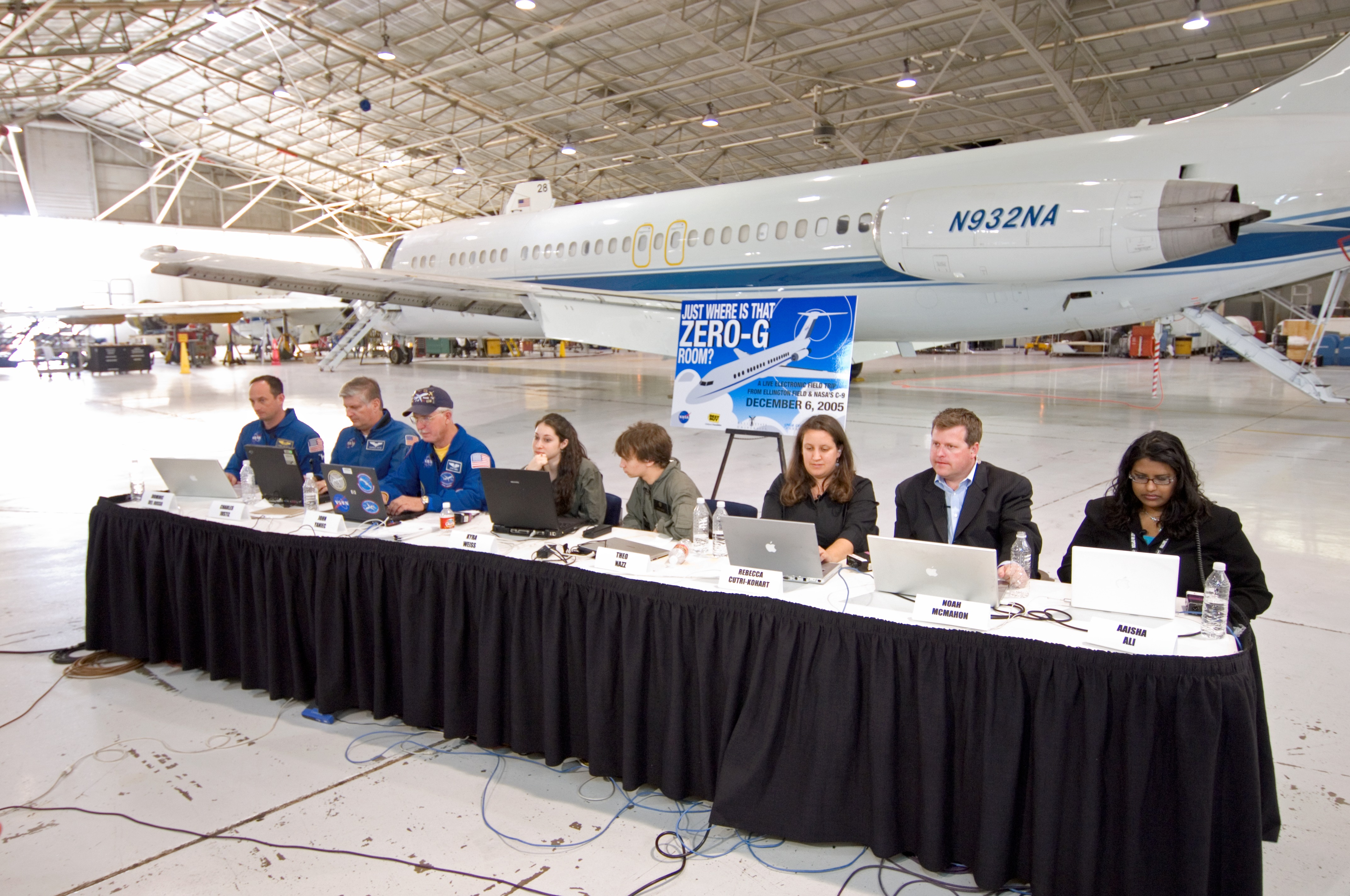
Aaisha Ali participates in a public affairs event at Ellington Field Joint Reserve Base in Houston in 2005. We don’t do it by ourselves. Everyone — from our engineers to custodial staff to cafeteria workers — plays a role in getting us to the Moon. NASA is for the world. And it takes all of us.Aaisha ali
Artemis Ground Control Flight Lead
Looking ahead, Ali is especially passionate about inspiring the Artemis Generation — those who will one day explore the Moon and Mars. She often shares advice with her nieces and nephews, including one determined nephew who has dreamed of becoming an astronaut since age 7.
“Do what you love, and NASA will find a place for you,” she said. “NASA is a big place. If you love the law, we have lawyers. If you love art, science, or technology, there’s a place for you. Passion is what we’re looking for.”
Aaisha Ali at Walt Disney World in Orlando, Florida.In her free time, Ali enjoys photography and connecting with nature by camping and visiting national parks. She also loves planning trips to Walt Disney World, meeting new people, experiencing different cultures, and learning new things.
Even as her days are packed with simulations and mission prep, Ali knows landing astronauts on the lunar surface for Artemis III is not far behind.
“There’s a lot of uphill left to climb,” she said. “But we’re ready.”
Explore More 4 min read Going the Distance: Lisa Pace Leads Exploration Development Integration at Johnson Article 1 week ago 5 min read Heather Cowardin Safeguards the Future of Space Exploration Article 2 weeks ago 4 min read I Am Artemis: Patrick Junen Article 2 weeks agoNASA Remembers Former Johnson Director Jefferson Howell
July 3, 2025
Jefferson Davis Howell, Jr., former director of NASA’s Johnson Space Center in Houston, died July 2, in Bee Cave, Texas. He was 85 years old.
Howell was a champion of the construction of the International Space Station, working on a deadline to complete the orbiting lab by 2004. He oversaw four space shuttle crews delivering equipment and hardware to reach that goal. He also served as director during a pivotal moment for the agency: the loss of STS-107 and the crew of space shuttle Columbia. He made it his personal responsibility to meet with the families, look after them, and attend memorial services, all while keeping the families informed of the accident investigation as it unfolded.
“Gen. Howell led NASA Johnson through one of the most difficult chapters in our history, following the loss of Columbia and her crew,” said acting associate administrator Vanessa Wyche. “He brought strength and steady direction, guiding the workforce with clarity and compassion. He cared deeply for the people behind the mission and shared his leadership skills generously with the team. We extend our heartfelt condolences to his family and all who knew and loved him.”
At the time of his selection as director, he was serving as senior vice president with Science Applications International Corporation (SAIC) as the program manager for the safety, reliability, and quality assurance contract at Johnson. Following the accident, he made it his mission to improve the relationship between the civil servant and contractor workforce. He left his position and the agency, in October 2005, shortly after the Return-to-Flight mission of STS-114.
“General Howell stepped into leadership at Johnson during a pivotal time, as the International Space Station was just beginning to take shape. He led and supported NASA’s successes not only in space but here on the ground — helping to strengthen the center’s culture and offering guidance through both triumph and tragedy,” said Steve Koerner, Johnson Space Center’s acting director. “On behalf of NASA’s Johnson Space Center, we offer our deepest sympathies to his family, friends, and all those who had the privilege of working alongside him. The impact of his legacy will continue to shape Johnson for decades to come.”
The Victoria, Texas, native was a retired lieutenant general in the U.S. Marine Corps with a decorated military career prior to his service at NASA. He flew more than 300 combat missions in Vietnam and Thailand.
Howell is survived by his wife Janel and two children. A tree dedication will be held at NASA Johnson’s memorial grove in the coming year.
-end-
Chelsey Ballarte
Johnson Space Center, Houston
281-483-5111
NASA Mission Monitoring Air Quality from Space Extended
4 min read
Preparations for Next Moonwalk Simulations Underway (and Underwater)Since launching in 2023, NASA’s Tropospheric Emissions: Monitoring of Pollution mission, or TEMPO, has been measuring the quality of the air we breathe from 22,000 miles above the ground. June 19 marked the successful completion of TEMPO’s 20-month-long initial prime mission, and based on the quality of measurements to date, the mission has been extended through at least September 2026. The TEMPO mission is NASA’s first to use a spectrometer to gather hourly air quality data continuously over North America during daytime hours. It can see details down to just a few square miles, a significant advancement over previous satellites.
“NASA satellites have a long history of missions lasting well beyond the primary mission timeline. While TEMPO has completed its primary mission, the life for TEMPO is far from over,” said Laura Judd, research physical scientist and TEMPO science team member at NASA’s Langley Research Center in Hampton, Virginia. “It is a big jump going from once-daily images prior to this mission to hourly data. We are continually learning how to use this data to interpret how emissions change over time and how to track anomalous events, such as smoggy days in cities or the transport of wildfire smoke.”
To view this video please enable JavaScript, and consider upgrading to a web browser that supports HTML5 video
By measuring nitrogen dioxide (NO2) and formaldehyde (HCHO), TEMPO can derive the presence of near-surface ozone. On Aug. 2, 2024 over Houston, TEMPO observed exceptionally high ozone levels in the area. On the left, NO2 builds up in the atmosphere over the city and over the Houston Ship Channel. On the right, formaldehyde levels are seen reaching a peak in the early afternoon. Formaldehyde is largely formed through the oxidation of hydrocarbons, an ingredient of ozone production, such as those that can be emitted by petrochemical facilities found in the Houston Ship Channel. Trent Schindler/NASA's Scientific Visualization StudioWhen air quality is altered by smog, wildfire smoke, dust, or emissions from vehicle traffic and power plants, TEMPO detects the trace gases that come with those effects. These include nitrogen dioxide, ozone, and formaldehyde in the troposphere, the lowest layer of Earth’s atmosphere.
“A major breakthrough during the primary mission has been the successful test of data delivery in under three hours with the help of NASA’s Satellite Needs Working Group. This information empowers decision-makers and first responders to issue timely air quality warnings and help the public reduce outdoor exposure during times of higher pollution,” said Hazem Mahmoud, lead data scientist at NASA’s Atmospheric Science Data Center located at Langley Research Center.
…the substantial demand for TEMPO's data underscores its critical role…hazem mahmoud
NASA Data Scientist
TEMPO data is archived and distributed freely through the Atmospheric Science Data Center. “The TEMPO mission has set a groundbreaking record as the first mission to surpass two petabytes, or 2 million gigabytes, of data downloads within a single year,” said Mahmoud. “With over 800 unique users, the substantial demand for TEMPO’s data underscores its critical role and the immense value it provides to the scientific community and beyond.” Air quality forecasters, atmospheric scientists, and health researchers make up the bulk of the data users so far.
To view this video please enable JavaScript, and consider upgrading to a web browser that supports HTML5 video
On April 14, strong winds triggered the formation of a huge dust storm in the U.S. central plains and fueled the ignition of grassland fires in Oklahoma. On the left, the NO2 plumes originating from the grassland fires are tracked hour-by-hour by TEMPO. Smoke can be discerned from dust as a source since dust is not a source of NO2. The animation on the right shows the ultraviolet (UV) aerosol index, which indicates particulates in the atmosphere that absorb UV light, such as dust and smoke. Trent Schindler/NASA's Scientific Visualization StudioThe TEMPO mission is a collaboration between NASA and the Smithsonian Astrophysical Observatory, whose Center for Astrophysics Harvard & Smithsonian oversees daily operations of the TEMPO instrument and produces data products through its Instrument Operations Center.
Datasets from TEMPO will be expanded through collaborations with partner agencies like the National Oceanic and Atmospheric Administration (NOAA), which is deriving aerosol products that can distinguish between smoke and dust particles and offer insights into their altitude and concentration.
To view this video please enable JavaScript, and consider upgrading to a web browser that supports HTML5 video
On May 5, TEMPO measured NO2 emissions over the Twin Cities in the center of Minnesota during morning rush hour. The NO2 increases seen mid-day through the early evening hours are illustrated by the red and black shaded areas at the Red River Valley along the North Dakota state line. These levels are driven by emissions from the soils in agriculturally rich areas. Agricultural soil emissions are influenced by environmental factors like temperature and moisture as well as fertilizer application. Small fires and enhancements from mining activities can also be seen popping up across the region through the afternoon.Trent Schindler/NASA's Scientific Visualization Studio“These datasets are being used to inform the public of rush-hour pollution, air quality alerts, and the movement of smoke from forest fires,” said Xiong Liu, TEMPO’s principal investigator at the Center for Astrophysics Harvard & Smithsonian. “The library will soon grow with the important addition of aerosol products. Users will be able to use these expanded TEMPO products for air quality monitoring, improving forecast models, deriving pollutant amounts in emissions and many other science applications.”
The TEMPO mission detects and highlights movement of smoke originating from fires burning in Manitoba on June 2. Seen in purple hues are observations made by TEMPO in the ultraviolet spectrum compared to Advanced Baseline Imagers (ABIs) on NOAA’s GOES-R series of weather satellites that do not have the needed spectral coverage. The NOAA GOES-R data paired with NASA’s TEMPO data enhance state and local agencies’ ability to provide near-real-time smoke and dust impacts in local air quality forecasts.NOAA/NESDIS/Center for Satellite Applications and Research“The TEMPO data validation has truly been a community effort with over 20 agencies at the federal and international level, as well as a community of over 200 scientists at research and academic institutions,” Judd added. “I look forward to seeing how TEMPO data will help close knowledge gaps about the timing, sources, and evolution of air pollution from this unprecedented space-based view.”
An agency review will take place in the fall to assess TEMPO’s achievements and extended mission goals and identify lessons learned that can be applied to future missions.
The TEMPO mission is part of NASA’s Earth Venture Instrument program, which includes small, targeted science investigations designed to complement NASA’s larger research missions. The instrument also forms part of a virtual constellation of air quality monitors for the Northern Hemisphere which includes South Korea’s Geostationary Environment Monitoring Spectrometer and ESA’s (European Space Agency) Sentinel-4 satellite. TEMPO was built by BAE Systems Inc., Space & Mission Systems (formerly Ball Aerospace). It flies onboard the Intelsat 40e satellite built by Maxar Technologies. The TEMPO Instrument Operations Center and the Science Data Processing Center are operated by the Smithsonian Astrophysical Observatory, part of the Center for Astrophysics | Harvard & Smithsonian in Cambridge.
For more information about the TEMPO instrument and mission, visit:
https://science.nasa.gov/mission/tempo/
About the AuthorCharles G. HatfieldScience Public Affairs Officer, NASA Langley Research Center Share Details Last Updated Jul 03, 2025 LocationNASA Langley Research Center Related Terms Explore More 3 min read NASA’s Hubble and Webb Telescopes Reveal Two Faces of a Star Cluster DuoA riotous expanse of gas, dust, and stars stake out the dazzling territory of a…
Article 1 day ago 3 min read Aaisha Ali: From Marine Biology to the Artemis Control Room Article 2 days ago 2 min read Hubble Observations Give “Missing” Globular Cluster Time to ShineA previously unexplored globular cluster glitters with multicolored stars in this NASA Hubble Space Telescope…
Article 5 days ago Keep Exploring Discover More Topics From NASAMissions
Humans in Space
Climate Change
Solar System
Hubble Observations Give “Missing” Globular Cluster Time to Shine
- Hubble Home
- Overview
- Science
- Impact & Benefits
- Observatory
- Team
- Multimedia
- News
- More
2 min read
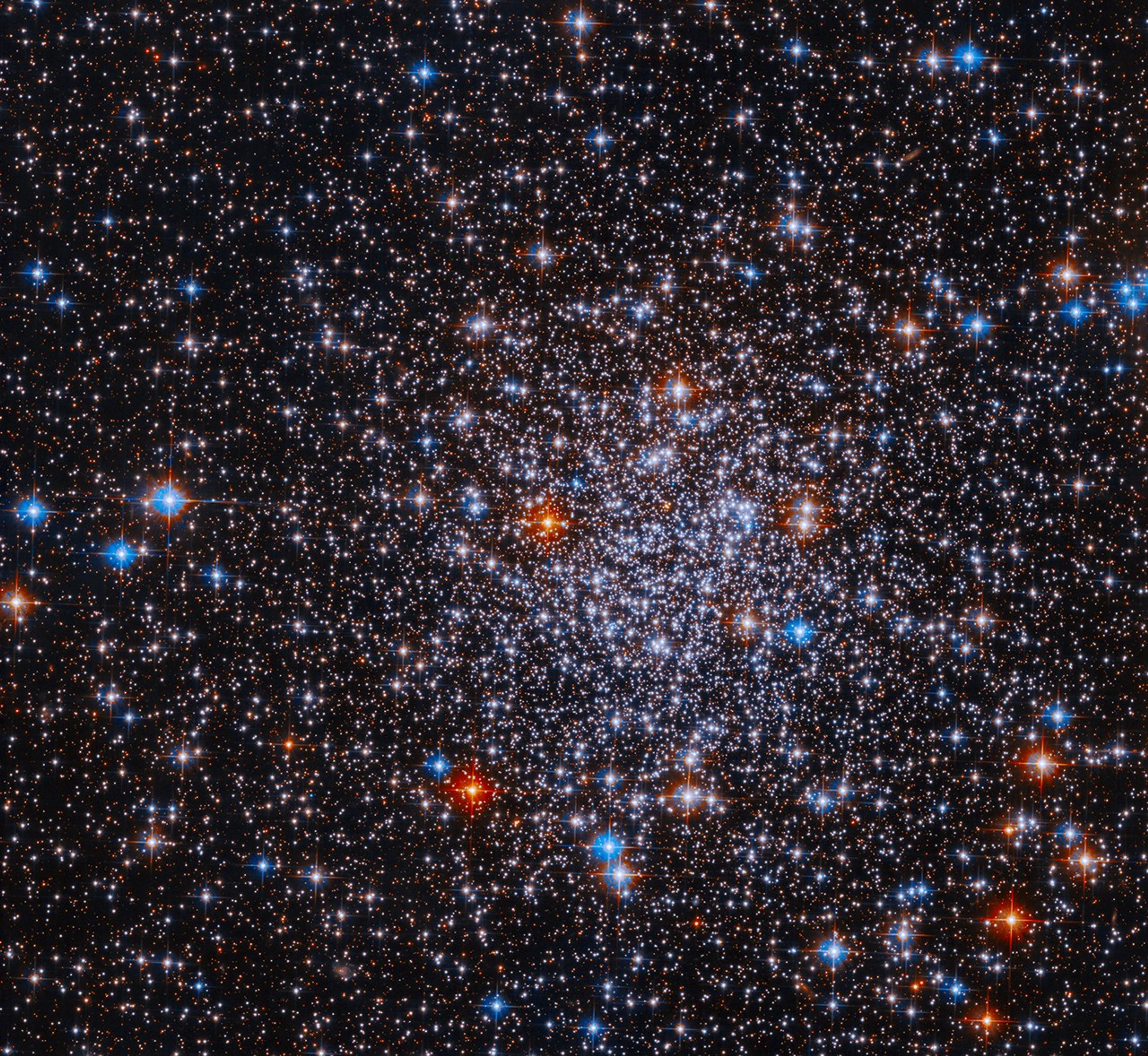
Hubble Observations Give “Missing” Globular Cluster Time to Shine This NASA Hubble Space Telescope image features a dense and dazzling array of blazing stars that form globular cluster ESO 591-12. NASA, ESA, and D. Massari (INAF — Osservatorio di Astrofisica e Scienza dello Spazio); Processing: Gladys Kober (NASA/Catholic University of America)Download this image
A previously unexplored globular cluster glitters with multicolored stars in this NASA Hubble Space Telescope image. Globular clusters like this one, called ESO 591-12 or Palomar 8, are spherical collections of tens of thousands to millions of stars tightly bound together by gravity. Globular clusters generally form early in the galaxies’ histories in regions rich in gas and dust. Since the stars form from the same cloud of gas as it collapses, they typically hover around the same age. Strewn across this image of ESO 591-12 are a number of red and blue stars. The colors indicate their temperatures; red stars are cooler, while the blue stars are hotter.
Hubble captured the data used to create this image of ESO 591-12 as part of a study intended to resolve individual stars of the entire globular cluster system of the Milky Way. Hubble revolutionized the study of globular clusters since earthbound telescopes are unable to distinguish individual stars in the compact clusters. The study is part of the Hubble Missing Globular Clusters Survey, which targets 34 confirmed Milky Way globular clusters that Hubble has yet to observe.
The program aims to provide complete observations of ages and distances for all of the Milky Way’s globular clusters and investigate fundamental properties of still-unexplored clusters in the galactic bulge or halo. The observations will provide key information on the early stages of our galaxy, when globular clusters formed.
Explore MoreHubble’s Star Clusters
Exploring the Birth of Stars
Facebook logo @NASAHubble @NASAHubble Instagram logo @NASAHubble
Media Contact:
Claire Andreoli
NASA’s Goddard Space Flight Center, Greenbelt, MD
claire.andreoli@nasa.gov
Since its 1990 launch, the Hubble Space Telescope has changed our fundamental understanding of the universe.
Hubble’s Cosmic Adventure
Hubble’s Night Sky Challenge
Hubble’s 35th Anniversary
NASA Advances Pressure Sensitive Paint Research Capability
5 min read
Preparations for Next Moonwalk Simulations Underway (and Underwater) The Swept Wing Flow Test model, known as SWiFT, with pressure sensitive paint applied, sports a pink glow under ultraviolet lights while tested during 2023 in a NASA wind tunnel at Langley Research Center in Virginia.NASA / Dave BowmanMany of us grew up using paint-by-number sets to create beautiful color pictures.
For years now, NASA engineers studying aircraft and rocket designs in wind tunnels have flipped that childhood pastime, using computers to generate images from “numbers-by-paint” – pressure sensitive paint (PSP), that is.
Now, advances in the use of high-speed cameras, supercomputers, and even more sensitive PSP have made this numbers-by-paint process 10,000 times faster while creating engineering visuals with 1,000 times higher resolution.
So, what’s the big difference exactly between the “old” capability in use at NASA for more than a decade and the “new?”
“The key is found by adding a single word in front of PSP, namely ‘unsteady’ pressure sensitive paint, or uPSP,” said E. Lara Lash, an aerospace engineer from NASA’s Ames Research Center in California’s Silicon Valley.
With PSP, NASA researchers study the large-scale effects of relatively smooth air flowing over the wings and body of aircraft. Now with uPSP, they are able to see in finer detail what happens when more turbulent air is present – faster and better than ever before.
In some cases with the new capability, researchers can get their hands on the wind tunnel data they’re looking for within 20 minutes. That’s quick enough to allow engineers to adjust their testing in real time.
Usually, researchers record wind tunnel data and then take it back to their labs to decipher days or weeks later. If they find they need more data, it can take additional weeks or even months to wait in line for another turn in the wind tunnel.
“The result of these improvements provides a data product that is immediately useful to aerodynamic engineers, structural engineers, or engineers from other disciplines,” Lash said.
Robert Pearce, NASA’s associate administrator for aeronautics, who recently saw a demonstration of uPSP-generated data displayed at Ames, hailed the new tool as a national asset that will be available to researchers all over the country.
“It’s a unique NASA innovation that isn’t offered anywhere else,” Pearce said. “It will help us maintain NASA’s world leadership in wind tunnel capabilities.”
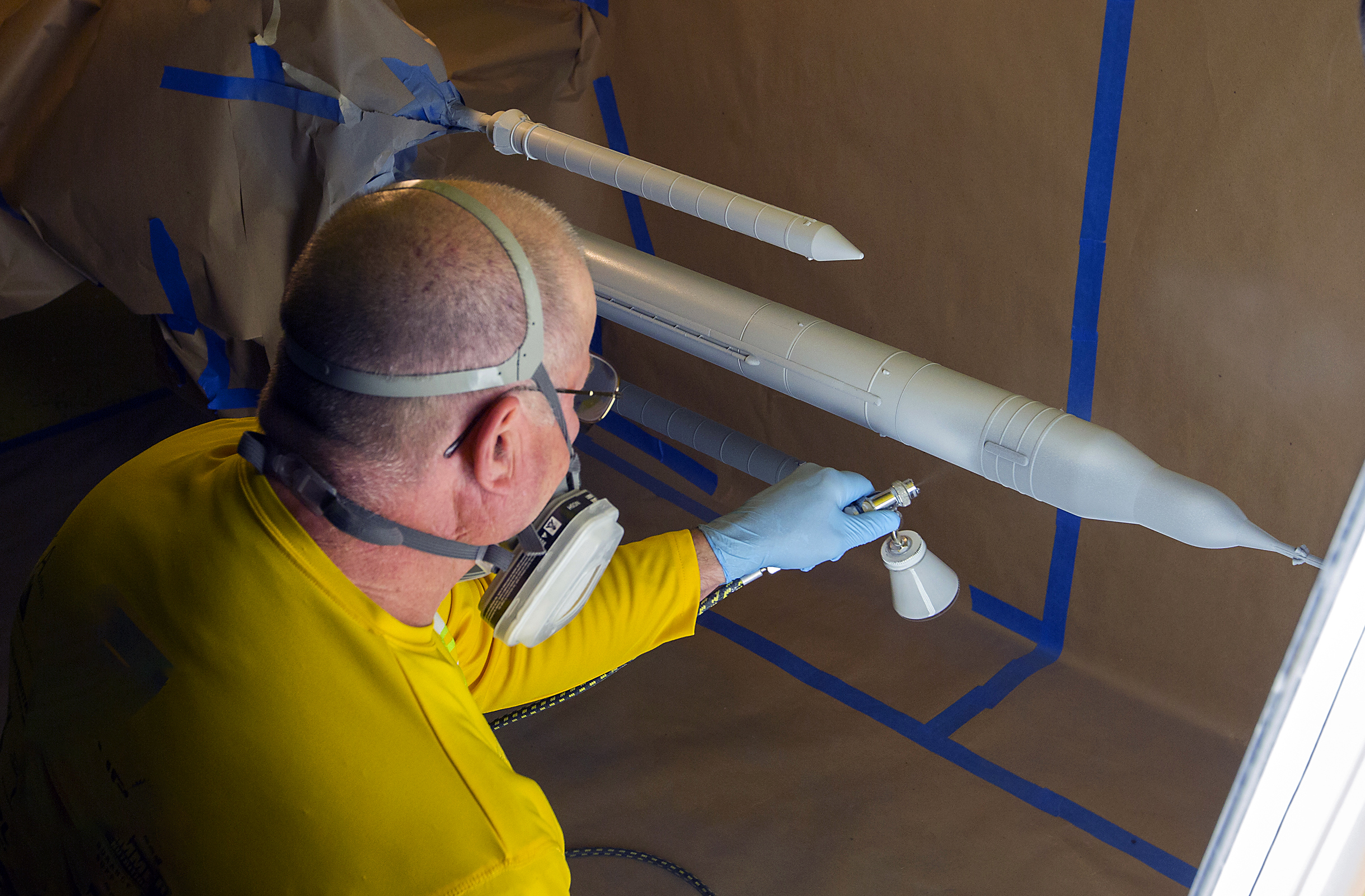
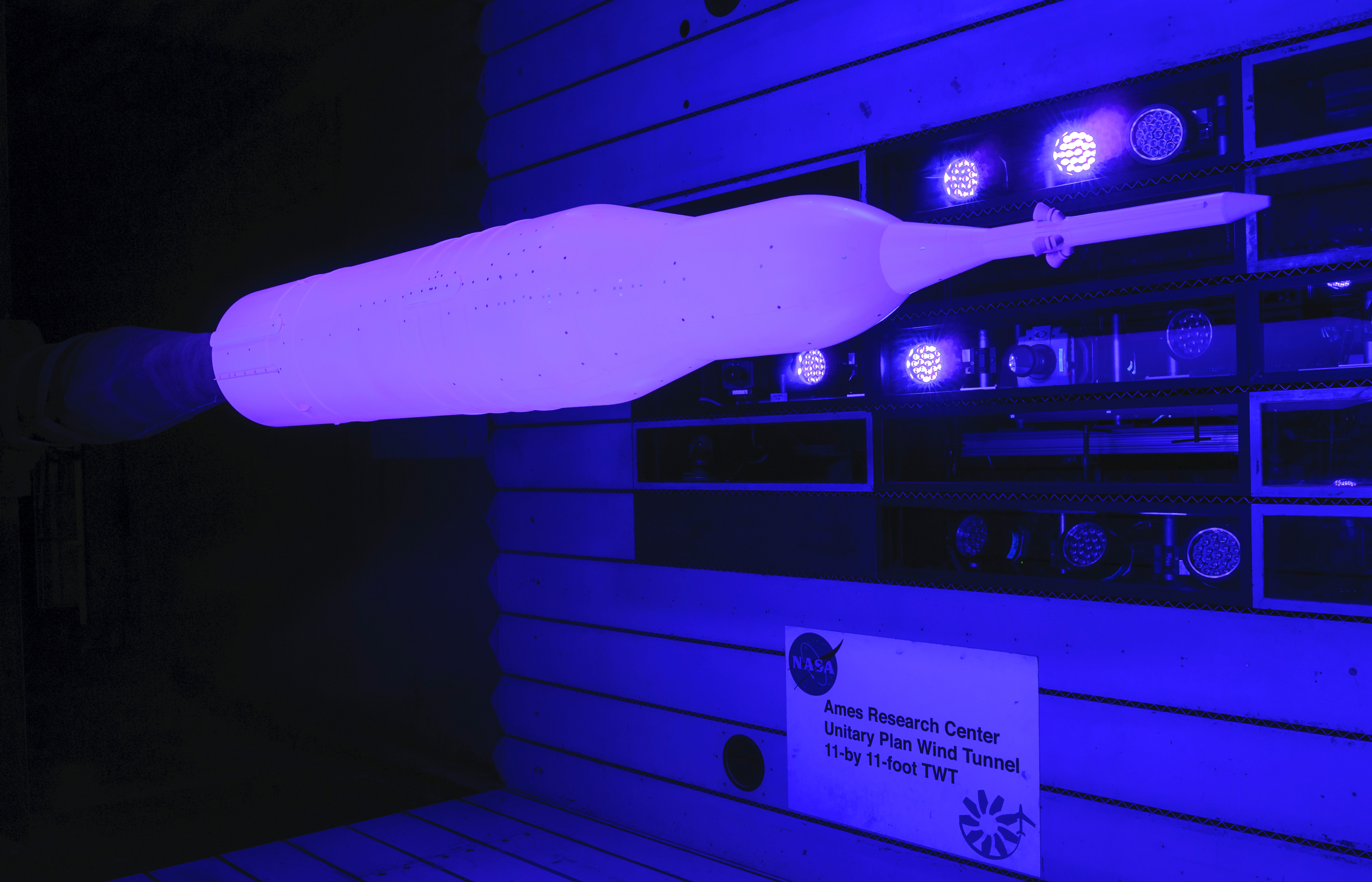
A technician sprays unsteady pressure sensitive paint onto the surface of a small model of the Space Launch System in preparation for testing in a NASA wind tunnel.NASA / Dave Bowman How it WorksWith both PSP and uPSP, a unique paint is applied to scale models of aircraft or rockets, which are mounted in wind tunnels equipped with specific types of lights and cameras.
When illuminated during tests, the paint’s color brightness changes depending on the levels of pressure the model experiences as currents of air rush by. Darker shades mean higher pressure; lighter shades mean lower pressure.
Cameras capture the brightness intensity and a supercomputer turns that information into a set of numbers representing pressure values, which are made available to engineers to study and glean what truths they can about the vehicle design’s structural integrity.
“Aerodynamic forces can vibrate different parts of the vehicle to different degrees,” Lash said. “Vibrations could damage what the vehicle is carrying or can even lead to the vehicle tearing itself apart. The data we get through this process can help us prevent that.”
Traditionally, pressure readings are taken using sensors connected to little plastic tubes strung through a model’s interior and poking up through small holes in key places, such as along the surface of a wing or the fuselage.
Each point provides a single pressure reading. Engineers must use mathematical models to estimate the pressure values between the individual sensors.
With PSP, there is no need to estimate the numbers. Because the paint covers the entire model, its brightness as seen by the cameras reveals the pressure values over the whole surface.
A four-percent scale model of the Space Launch System rocket is tested in 2017 using unsteady Pressure Sensitive Paint inside the 11-foot by 11-foot Unitary Plan Wind Tunnel at NASA’s Ames Research Center in California.NASA / Dominic Hart Making it BetterThe introduction, testing, and availability of uPSP is the result of a successful five-year-long effort, begun in 2019, in which researchers challenged themselves to significantly improve the PSP’s capability with its associated cameras and computers.
The NASA team’s desire was to develop and demonstrate a better process of acquiring, processing, and visualizing data using a properly equipped wind tunnel and supercomputer, then make the tool available at NASA wind tunnels across the country.
The focus during a capability challenge was on NASA’s Unitary Plan Facility’s 11-foot transonic wind tunnel, which the team connected to the nearby NASA Advanced Supercomputing Facility, both located at Ames.
Inside the wind tunnel, a scale model of NASA’s Space Launch System rocket served as the primary test subject during the challenge period.
Now that the agency has completed its Artemis I uncrewed lunar flight test mission, researchers can match the flight-recorded data with the wind tunnel data to see how well reality and predictions compare.
With the capability challenge officially completed at the end of 2024, the uPSP team is planning to deploy it to other wind tunnels and engage with potential users with interests in aeronautics or spaceflight.
“This is a NASA capability that we have, not only for use within the agency, but one that we can offer industry, academia, and other government agencies to come in and do research using these new tools,” Lash said.
NASA’s Aerosciences Evaluation and Test Capabilities portfolio office, an organization managed under the agency’s Aeronautics Research Mission Directorate, oversaw the development of the uPSP capability.
Watch this uPSP Video About the AuthorJim BankeManaging Editor/Senior WriterJim Banke is a veteran aviation and aerospace communicator with more than 40 years of experience as a writer, producer, consultant, and project manager based at Cape Canaveral, Florida. He is part of NASA Aeronautics' Strategic Communications Team and is Managing Editor for the Aeronautics topic on the NASA website.
Facebook logo @NASA@NASAaero@NASA_es @NASA@NASAaero@NASA_es Instagram logo @NASA@NASAaero@NASA_es Linkedin logo @NASA Explore More 4 min read NASA Mission Monitoring Air Quality from Space Extended Article 4 days ago 6 min read By Air and by Sea: Validating NASA’s PACE Ocean Color Instrument Article 2 weeks ago 3 min read NASA Intern Took Career from Car Engines to Cockpits Article 2 weeks ago Keep Exploring Discover More Topics From NASAMissions
Artemis
Aeronautics STEM
Explore NASA’s History
Share Details Last Updated Jul 03, 2025 EditorJim BankeContactJim Bankejim.banke@nasa.gov Related TermsOld Glory on the Red Planet
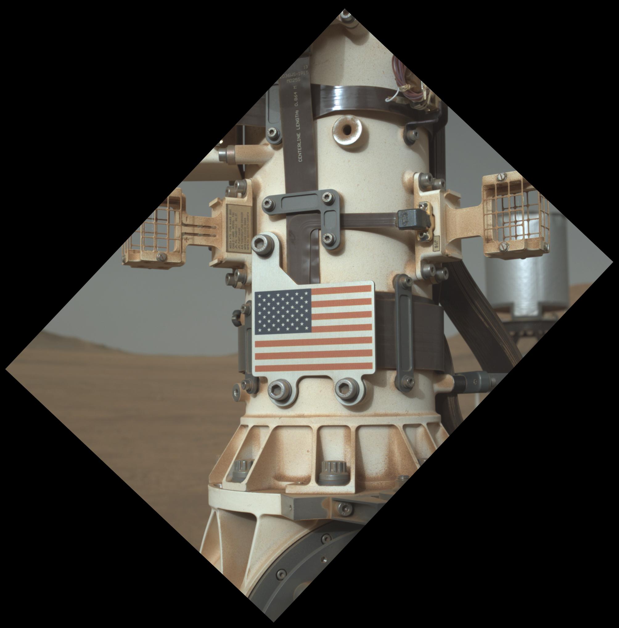
The United States flag adorns an aluminum plate mounted at the base of the mast, or “head,” of NASA’s Perseverance Mars rover. This image of the plate was taken on June 28, 2025 (the 1,548th day, or sol, of the mission), by the WATSON (Wide Angle Topographic Sensor for Operations and eNgineering) camera on the end of the rover’s robotic arm.
WATSON, part of an instrument called SHERLOC (Scanning Habitable Environments with Raman & Luminescence for Organics & Chemicals), was built by Malin Space Science Systems (MSSS) in San Diego and is operated jointly by MSSS and NASA’s Jet Propulsion Laboratory in Southern California. JPL, which is managed for the agency by Caltech, built and manages operations of the Perseverance rover.
