
NASA - Breaking News
The Marshall Star for May 29, 2024
By Wayne Smith
NASA’s Marshall Space Flight Center will celebrate its 65th birthday next summer, and while there are plans to honor the center’s rich history, there is also More to Marshall ahead.
Team members at NASA’s Marshall Space Flight Center listen to Center Director Joseph Pelfrey, background center, share updates on culture and strategy during the spring all-hands meeting May 20 in Activities Building 4316. NASA/Danielle BurlesonThat was part of the message Center Director Joseph Pelfrey delivered during the spring all-hands meeting May 20 in Activities Building 4316. He highlighted Marshall’s transformative shift to more strategic partnerships across NASA and with industry, with the center continuing to serve as a technical solutions provider.
“More to Marshall is a systematic approach that will reinforce our center’s strategy and our role in space exploration,” Pelfrey said. “We align this vision with the core values of our Marshall fabric. We are not replacing our roots; we are fostering them to grow stronger and reach farther.”
Pelfrey also discussed the center’s evolving culture, highlighting April outreach activities, including the Total Solar Eclipse event in Russellville, Arkansas, First Robotics, Student Launch, and the Human Exploration Rover Challenge.
Marshall Deputy Director Rae Ann Meyer, second from right, responds to an audience question during a question-and-answer panel the May 20 all-hands meeting. At left, Lance D. Davis, Marshall’s public affairs and news chief, moderates the panel, while Pelfrey, center left, and Larry Leopard, Marshall’s associate director, technical, far right, listen in.NASA/Danielle Burleson“These events emulate the Marshall culture,” Pelfrey said. “I am proud of the impact you have on the community, the Artemis Generation, and across the globe.”
New Deputy Director Rae Ann Meyer followed Pelfrey’s opening remarks, focusing on the center’s newest culture initiatives. Meyer also invited Trace Turner, management assistant in the Office of the Director, to highlight the efforts of three Center Action Teams leading the charge on Marshall’s culture initiatives. Team leaders Rocio Garcia, Benjamin Ferrell, and Mason Quick each shared more about their respective team’s projects, including the development of a user-friendly app that will share information on Marshall, NASA’s Michoud Assembly Facility, Redstone Arsenal, and the community.
Larry Leopard, Marshall’s associate director, technical, provided an update on the center’s efforts to address knowledge management concerns, starting with events like Meals with Mentors, Center Strategy Brown Bags and Tech Talk presentations, and after-action reviews.
Center Action Team leader Rocio Garcia shares plans to develop a user-friendly app for Marshall team members and the public, which will serve as a one-stop shop for information on Marshall, NASA’s Michoud Assembly Facility, Redstone Arsenal, and the community.NASA/Danielle BurlesonFinally, before Marshall leadership participated in a question-and-answer panel, Pelfrey shared updates on center strategy, infrastructure, NASA’s budget, and NASA 2040.
“We will build on the success of our center strategy,” Pelfrey said. “We will continue to implement and mature our pursuits culture, always seeking challenging and exciting opportunities, using our skills, expertise, capabilities, and infrastructure while continuing to build partnerships with industry and academia. Marshall has a tremendous role in returning humans to the Moon, reaching Mars, and exploring the cosmos.”
Team members can watch a recording of the all-hands meeting on Inside Marshall.
Smith, a Media Fusion employee and the Marshall Star editor, supports the Marshall Office of Communications.
Les Johnson Named Center Chief Technologist at MarshallLes Johnson has been named center chief technologist at NASA’s Marshall Space Flight Center, effective June 2.
Johnson will provide expert advice on technology initiatives to center leadership and to Marshall team members. He will lead the Marshall team on matters involving center-wide technology development. Johnson also will represent Marshall on NASA’s Center Technology Council and serves as the center’s focal point for Center Innovation Fund activities.
Les Johnson has been named center chief technologist at NASA’s Marshall Space Flight Center.NASAHe has been a principal technologist for several of NASA’s advanced in-propulsion and power technology developments during his 33-year career at Marshall. Johnson served as the principal investigator of the Propulsive Small Expendable Deployer System (ProSEDS) tether propulsion project and Near-Earth Asteroid Scout solar sail mission. He was a co-investigator (Co-I) of the JAXA T-Rex tether propulsion demonstration, the European Union’s InflateSail, and NASA’s Lightweight Integrated Solar Array and anTenna (LISA-T) missions, as well as a Co-I on multiple NASA Innovative Advanced Concepts (NIAC) studies.
Johnson began his NASA career in 1990 working in the Program Development Directorate formulating new space science mission concepts. Shortly thereafter, he became the manager for NASA’s Interstellar Propulsion Technology Project that transitioned into the In-Space Propulsion Technology Program, which he managed on behalf of the Office of Space Science. He then served as the formulation manager for the Nuclear Systems Initiative, which became Project JIMO. Johnson served as deputy manager and technical assistant for the Advanced Concepts Office, before being selected to lead the development of the Solar Cruiser solar sail propulsion system in the Science and Technology Office.
Prior to NASA, he worked three years for General Research Corp. on directed energy systems in support of the Strategic Defense Initiative.
Johnson holds three patents. His awards include NASA’s Exceptional Technology Achievement Medal, NASA’s Exceptional Achievement Medal (twice), Marshall’s Technology Transfer and Innovation Awards, and he has been a Rotary Stellar Award finalist two times. As an outside activity, he is also an award-winning author.
A native of Ashland, Kentucky, Johnson earned his bachelor’s degree from Transylvania University and his master’s degree from Vanderbilt University.
Take 5 with Jose MatienzoBy Wayne Smith
Growing up in the small village of Luquillo, Puerto Rico, Jose Matienzo would fly paper airplanes and launch model rockets from atop the building he lived in with his family.
“I knew then that I wanted to be some sort of engineer, I just didn’t know what it was called,” Matienzo said. “I never imagined that I actually would work for NASA, but I thought I could design cars or planes. I liked drawing them.”
Jose Matienzo began his NASA career in 1983 at the agency’s Marshall Space Flight Center.Photo courtesy of Jose MatienzoFlash forward more than five decades later. Matienzo is in his 42nd year working with NASA and the agency’s Marshall Space Flight Center as he nears retirement in December. Center team members will remember him as manager of the Marshall Exchange for the past 12 years, enjoying his witty daily email from the Exchange.
“Literally every day was fun trying to make life better for our team members,” Matienzo said of his team with the Exchange. “That includes bringing the food truck court, being able to have employee clothing of all styles and types, creating new clubs, and expanding facilities.”
He is currently assigned to a position with NASA’s Source Evaluation Board.
As he approaches retirement, Matienzo still finds it difficult to fathom his many milestones working with NASA and Marshall, where he began his career in 1983 as a co-op student in the structural dynamics division and worked on the Space Shuttle Program for 12 years. Matienzo followed that with a year at NASA Headquarters before returning to Marshall as lead engineer on several projects related to the International Space Station, such as the space station element transportation system.
His other assignments have included managing the NASA office at the Naval Research Center; the Marshall lead for supporting the Launch Services Program, including the office at the United Launch Alliance rocket plant in Decatur; technical assistant for former Marshall Director Robert Lightfoot; and more.
“There have been so many memories over the years,” Matienzo said. “Six months after becoming a full-time employee, the Challenger accident happened. At the time I had no idea what the possible impact of that accident would be. We all had a little part on returning to flight, so watching the first launch afterwards was a fantastic moment.
“We delivered space station hardware in partnership with the Italians and the European Space Agency, helped train the astronauts who performed the Hubble Telescope repair, and most recently, we made improvements to the Exchange services to make life at work better for our employees.”
Question: What excites you most about the future of human space exploration, or your NASA work, and your team’s role it?
Matienzo: I’ve been here for a long time and our future missions and goals have changed over the years. But no matter what, there’s always been excitement about meeting the agency’s goals and Marshall’s role in providing space transportation, lunar landers, and even Mars sample return vehicles. That and all of the support and testing work that comes with it is fun!
Question: Who or what drives/motivates you?
Matienzo: I’ve been lucky that my job assignments have always been fun and self-motivating, but certainly dealing and coordinating with colleagues in accomplishing a mutual goal, test, or assignment is very rewarding.
Question: What advice do you have for employees early in their NASA career or those in new leadership roles?
Matienzo: Network! As you get to know others and learn what they do, you will find out how everything comes together at NASA and where other opportunities may be out there for you. For our leaders: keep encouraging, mentoring, and creating opportunities for the employees to experience, learn, and grow.
Question: What do you enjoy doing with your time while away from work?
Matienzo: My kids are older now so keeping in touch is fun. But I do have grandkids to play with. Otherwise, I play congas with my bandmates, love to do social dancing, play lots of pickleball, and enjoy mountain and road bike riding.
Question: What plans do you have for retirement?
Matienzo: I want to move closer to the beach. I love Huntsville, so I want to keep a presence here. I also plan to bike all over the USA!
Smith, a Media Fusion employee and the Marshall Star editor, supports the Marshall Office of Communications.
Marshall Team Supports Safe Travels for Space Station ScienceBy Jessica Barnett
During the International Space Station’s more than 25 years of operation, there have been more than 3,000 experiments conducted aboard the microgravity laboratory, and making sure scientific samples are kept safe through launch, spaceflight, experimentation, and the return trip to Earth takes a great deal of planning, testing, and preparation across NASA.
In February, team members at NASA’s Marshall Space Flight Center handled the de-integration of zinc selenide-based crystals grown on the space station as part of an experiment to study how a lack of gravity might affect the crystals’ growth and structure. The experiment was conducted using six sample cartridge assemblies heated up to 1,200 degrees Celsius (2,192 degrees Fahrenheit) inside the Materials Science Laboratory of the Materials Science Research Rack on the space station.
NASA Marshall Space Flight Center’s payload technician Chris Honea, left, and quality assurance specialist Keith Brandon, right, on Feb. 29 carefully inspect the temperature sensors that help gather data and monitor progress during a crystals experiment. The zinc selenide-based crystals were grown on the International Space Station as part of an experiment to see how gravity affects their structure or growth, then de-integrated and inspected in Marshall’s Space Systems Integration & Test Facility.NASAJohn Luke Bili, lead systems test engineer for the sample cartridge assemblies within Marshall’s Instrument Development, Integration, and Test Branch, begins the process by working with engineers, scientists, project personnel, and the experiment’s principal investigator to create an ampoule, or sealed glass vial, to use as a sample container.
“We’ll take the ampoule and do some ground testing, like a normal flight integration,” Bili said. “We’ll assemble it with the hardware we have, then we are responsible for completing different mitigation efforts to prepare for sealing the ampoule up and processing it at the required high temperatures.”
The team exposes the test article to extreme heat and pressure using a duplicate of the furnace on the space station, allowing them to also test the experiment’s software.
The zinc selenide-based crystal experiment required six sample cartridge assemblies. After a month of preparation from Marshall’s team, the assemblies traveled to NASA’s Johnson Space Center for a final round of packing before arriving at the agency’s Kennedy Space Center for launch.
The assemblies launched on NASA’s SpaceX 24th commercial resupply services mission in December 2021 and NASA’s Northrop Grumman 19th commercial resupply services mission in August 2023. Each sample took about a week to process through the space station’s lab furnace. The samples were then brought back to Earth, with three of the six arriving at Marshall on Feb. 9.
An ampoule containing zinc selenide-based crystals rests on a table in Marshall Space Flight Center’s Space Systems Integration & Test Facility. The ampoule was part of the sixth sample cartridge assembly retrieved from the International Space Station as part of an experiment to see how gravity affects the crystals’ structure or growth.NASAWhile unpacking the crystal samples, team members took photos and notes of the tubes throughout the de-integration process in Marshall’s Space Systems Integration & Test Facility. The team includes technicians with 20 to 30 years of experience, ensuring samples safely travel to and from the station and helping expand access for researchers to explore microgravity, space exposure, and future missions in low Earth orbit.
“It’s really nice having that kind of experience when we’re working on the hardware that’s going in space,” he said. “We’ve got a lot of people that are very skilled machinists that are able to help us in a moment’s notice, we have people with a really good understanding of technical tolerances and stuff like that, and we have people with a lot of varying experience doing flight hardware integration and tests.”
For more than two decades, humans have lived and worked continuously aboard the International Space Station, advancing scientific knowledge and making research breakthroughs that are not possible on Earth. The station is a critical testbed for NASA to understand and overcome the challenges of long-duration spaceflight and to expand commercial opportunities in low Earth orbit.
Learn more about the space station.
Barnett, a Media Fusion employee, supports the Marshall Office of Communications.
Spotted: ‘Death Star’ Black Holes in ActionA team of astronomers have studied 16 supermassive black holes that are firing powerful beams into space, to track where these beams, or jets, are pointing now and where they were aimed in the past, as reported in a press release. Using NASA’s Chandra X-ray Observatory and the U.S. National Science Foundation (NSF) National Radio Astronomical Observatory’s (NRAO) Very Large Baseline Array (VLBA), they found that some of the beams have changed directions by large amounts.
These two Chandra images show hot gas in the middle of the galaxy cluster Abell 478, left, and the galaxy group NGC 5044, right.X-ray: NASA/CXC/Univ. of Bologna/F. Ubertosi; Insets Radio: NSF/NRAO/VLBA; Wide field Image: Optical/IR: Univ. of Hawaii/Pan-STARRS; Image Processing: NASA/CXC/SAO/N. WolkThese two Chandra images show hot gas in the middle of the galaxy cluster Abell 478 (left) and the galaxy group NGC 5044 (right). The center of each image contains one of the sixteen black holes firing beams outwards. Each black hole is in the center of a galaxy embedded in the hot gas.
In the images below, labels and the radio images appear. Ellipses show a pair of cavities in the hot gas for Abell 478, left, and ellipses show two pairs of cavities for NGC 5044, right. These cavities were carved out by the beams millions of years ago, giving the directions of the beams in the past. An X shows the location of each supermassive black hole.
The VLBA images are shown as insets, which reveal where the beams are currently pointing, as seen from Earth. The radio images are both much smaller than the X-ray images. For Abell 478 the radio image is about 3% of the width of the Chandra image and for NGC 5044 the radio image is about 4% of the Chandra image’s width.
A labeled version of the image.X-ray: NASA/CXC/Univ. of Bologna/F. Ubertosi; Insets Radio: NSF/NRAO/VLBA; Wide field Image: Optical/IR: Univ. of Hawaii/Pan-STARRS; Image Processing: NASA/CXC/SAO/N. WolkA comparison between the Chandra and VLBA images shows that the beams for Abell 478 changed direction by about 35 degrees and the beams for NGC 5044 changed direction by about 70 degrees.
Across the entire sample the researchers found that about a third of the 16 galaxies have beams that are pointing in completely different directions than they were before. Some have changed directions by nearly 90 degrees in some cases, and over timescales between one million years and a few tens of millions of years. Given that the black holes are of the order of 10 billion years old, this represents a relatively rapid change for these galaxies.
Black holes generate beams when material falls onto them via a spinning disk of matter and some of it then gets redirected outward. The direction of the beams from each of these giant black holes, which are likely spinning, is thought to align with the rotation axis of the black hole, meaning that the beams point along a line connecting the poles.
These beams are thought to be perpendicular to the disk. If material falls towards the black holes at a different angle that is not parallel to the disk, it could affect the direction of the black hole’s rotation axes, changing the direction of the beams.
Wide field views of Abell 478, left, and NGC 5044, right.X-ray: NASA/CXC/Univ. of Bologna/F. Ubertosi et al.; Optical/IR: Univ. of Hawaii/Pan-STARRS; IR: NASA/ESA/JPL/CalTech/Herschel Space TelescopeScientists think that beams from black holes and the cavities they carve out play an important role in how many stars form in their galaxies. The beams pump energy into the hot gas in and around the galaxy, preventing it from cooling down enough to form huge numbers of new stars. If the beams change directions by large amounts, they can tamp down star formation across much larger areas of the galaxy.
The paper describing these results was published in the January 20th, 2024 issue of The Astrophysical Journal, and is available here. The authors are Francesco Ubertosi (University of Bologna in Italy), Gerritt Schellenberger (Center for Astrophysics | Harvard & Smithsonian), Ewan O’Sullivan (CfA), Jan Vrtilek (CfA), Simona Giacintucci (Naval Research Laboratory), Laurence David (CfA), William Forman (CfA), Myriam Gitti (University of Bologna), Tiziana Venturi (National Institute of Astrophysics—Institute of Radio Astronomy in Italy), Christine Jones (CfA), and Fabrizio Brighenti (University of Bologna).
NASA’s Marshall Space Flight Center manages the Chandra program. The Smithsonian Astrophysical Observatory’s Chandra X-ray Center controls science from Cambridge Massachusetts and flight operations from Burlington, Massachusetts.
Read more from NASA’s Chandra X-ray Observatory.
NASA, IBM Research to Release New AI Model for Weather, ClimateBy Jessica Barnett
Working together, NASA and IBM Research have developed a new artificial intelligence model to support a variety of weather and climate applications. The new model – known as the Prithvi-weather-climate foundational model – uses artificial intelligence (AI) in ways that could vastly improve the resolution we’ll be able to get, opening the door to better regional and local weather and climate models.
Foundational models are large-scale, base models which are trained on large, unlabeled datasets and can be fine-tuned for a variety of applications. The Prithvi-weather-climate model is trained on a broad set of data – in this case NASA data from NASA’s Modern-Era Retrospective analysis for Research and Applications (MERRA-2)– and then makes use of AI learning abilities to apply patterns gleaned from the initial data across a broad range of additional scenarios.
With the Prithvi-weather-climate foundational model, researchers will be able to support many climate applications that can be used throughout the science community. These applications include detecting and improving models for severe weather patterns or natural disasters such as hurricanes. NASA’s Terra satellite acquired this image of Idalia in August 2023. NASA Earth Observatory“Advancing NASA’s Earth science for the benefit of humanity means delivering actionable science in ways that are useful to people, organizations, and communities. The rapid changes we’re witnessing on our home planet demand this strategy to meet the urgency of the moment,” said Karen St. Germain, director of the Earth Science Division of NASA’s Science Mission Directorate. “The NASA foundation model will help us produce a tool that people can use: weather, seasonal and climate projections to help inform decisions on how to prepare, respond and mitigate.”
With the Prithvi-weather-climate model, researchers will be able to support many different climate applications that can be used throughout the science community. These applications include detecting and predicting severe weather patterns or natural disasters, creating targeted forecasts based on localized observations, improving spatial resolution on global climate simulations down to regional levels, and improving the representation of how physical processes are included in weather and climate models.
“These transformative AI models are reshaping data accessibility by significantly lowering the barrier of entry to using NASA’s scientific data,” said Kevin Murphy, NASA’s chief science data officer, Science Mission Directorate at NASA Headquarters. “Our open approach to sharing these models invites the global community to explore and harness the capabilities we’ve cultivated, ensuring that NASA’s investment enriches and benefits all.”
Prithvi-weather-climate was developed through an open collaboration with IBM Research, Oak Ridge National Laboratory, and NASA, including the agency’s Interagency Implementation and Advanced Concepts Team (IMPACT) at NASA’s Marshall Space Flight Center.
Prithvi-weather-climate can capture the complex dynamics of atmospheric physics even when there is missing information thanks to the flexibility of the model’s architecture. This foundational model for weather and climate can scale to both global and regional areas without compromising resolution.
“This model is part of our overall strategy to develop a family of AI foundation models to support NASA’s science mission goals,” said Rahul Ramachandran, who leads IMPACT at Marshall. “These models will augment our capabilities to draw insights from our vast archives of Earth observations.”
Prithvi-weather-climate is part of a larger model family– the Prithvi family – which includes models trained on NASA’s Harmonized LandSat and Sentinel-2 data. The latest model serves as an open collaboration in line with NASA’s open science principles to make all data accessible and usable by communities everywhere. It will be released later this year on Hugging Face, a machine learning and data science platform that helps users build, deploy, and train machine learning models.
“The development of the NASA foundation model for weather and climate is an important step towards the democratization of NASA’s science and observation mission,” said Tsendgar Lee, program manager for NASA’s Research and Analysis Weather Focus Area, High-End Computing Program, and Data for Operation and Assessment. “We will continue developing new technology for climate scenario analysis and decision making.”
Along with IMPACT and IBM Research, development of Prithvi-weather-climate featured significant contributions from NASA’s Office of the Chief Science Data Officer, NASA’s Global Modeling and Assimilation Office at Goddard Space Flight Center, Oak Ridge National Laboratory, the University of Alabama in Huntsville, Colorado State University, and Stanford University.
Learn more about Earth data and previous Prithvi models.
Barnett, a Media Fusion employee, supports the Marshall Office of Communications.
Psyche Fires Up Its Sci-Fi-Worthy ThrustersNASA’s Psyche spacecraft passed its six-month checkup with a clean bill of health, and there’s no holding back now. Navigators are firing its futuristic-looking electric thrusters, which emit a blue glow, nearly nonstop as the orbiter zips farther into deep space.
The spacecraft launched from NASA’s Kennedy Space Center atop a SpaceX Falcon Heavy on Oct. 13, 2023. After leaving Earth’s atmosphere, Psyche made the most of its rocket boost and coasted beyond the orbit of Mars.
For the next year, the spacecraft will be in what mission planners call “full cruise” mode, when its electric thrusters take over and propel the orbiter toward the asteroid belt. The thrusters work by expelling charged atoms, or ions, of xenon, emitting a brilliant blue glow that trails behind the spacecraft.
This artist’s concept depicts NASA’s Psyche spacecraft headed to the metal-rich asteroid Psyche in the main asteroid belt between Mars and Jupiter. The spacecraft launched in October 2023 and will arrive at its destination in 2029.NASA/JPL-Caltech/ASUThey are part of Psyche’s incredibly efficient solar electric propulsion system, which is powered by sunlight. The thrust created by the ionized xenon is gentle, but it does the job. Even in full cruise mode, the pressure exerted by the thrusters is about what you’d feel holding three quarters in your hand.
The orbiter is now more than 190 million miles away and moving at a clip of 23 miles per second, relative to Earth. That’s about 84,000 mph. Over time, with no atmospheric drag to slow it down, Psyche will accelerate to speeds of up to 124,000 mph.
The spacecraft will arrive at the metal-rich asteroid Psyche in 2029 and will make observations from orbit for about two years. The data it collects will help scientists better understand the formation of rocky planets with metallic cores, including Earth. Scientists have evidence that the asteroid, which is about 173 miles across at its widest point, may be the partial core of a planetesimal, the building block of an early planet.
The flight team used Psyche’s first 100 days in space to conduct a full checkout of all spacecraft systems. All of the engineering systems are working just as expected, and the three science instruments have been operating without a hitch. The magnetometer is working so well that it was able to detect an eruption of charged particles from the Sun, as did the gamma-ray and neutron spectrometer. And this past December, the twin cameras on the imaging instrument captured their first images.
This photo captures an operating electric thruster identical to those being used to propel NASA’s Psyche spacecraft. The blue glow comes from the charged atoms, or ions, of xenon.NASA/JPL-Caltech“Until this point, we have been powering on and checking out the various pieces of equipment needed to complete the mission, and we can report they are working beautifully,” said Henry Stone, Psyche project manager at NASA’s Jet Propulsion Laboratory, which manages the mission. “Now we are on our way and looking forward to an upcoming close flyby of Mars.”
That’s because the spacecraft’s trajectory will bring it back toward the Red Planet in the spring of 2026. The spacecraft will power down the thrusters as it coasts toward Mars, using the planet’s gravity to slingshot itself out. From there, the thrusters return to full cruise mode. Next stop: the asteroid Psyche.
In the meantime, the Deep Space Optical Communications technology demonstration aboard the spacecraft will keep on testing its mettle. The experiment already surpassed expectations when, in April, it transmitted test data from over 140 million miles away at a rate of 267 megabits per second to a downlink station on Earth – a bit rate comparable to broadband internet download speeds.
Arizona State University leads the Psyche mission. A division of Caltech in Pasadena, JPL is responsible for the mission’s overall management, system engineering, integration and test, and mission operations. Maxar Technologies in Palo Alto, California, provided the high-power solar electric propulsion spacecraft chassis.
JPL manages DSOC for the Technology Demonstration Missions program within NASA’s Space Technology Mission Directorate and the Space Communications and Navigation program within the Space Operations Mission Directorate.
Psyche is the 14th mission selected as part of NASA’s Discovery Program, which is managed by the agency’s Marshall Space Flight Center. NASA’s Launch Services Program, based at Kennedy, managed the launch service.
NASA’s OSIRIS-APEX Unscathed After Searing Pass of SunMission engineers were confident NASA’s OSIRIS-APEX (Origins, Spectral Interpretation, Resource Identification – Apophis Explorer) spacecraft could weather its closest ever pass of the Sun on Jan. 2. Their models had predicted that, despite traveling 25 million miles closer to the heat of the Sun than it was originally designed to, OSIRIS-APEX and its components would remain safe.
The mission team confirmed that the spacecraft indeed had come out of the experience unscathed after downloading stored telemetry data in mid-March. The team also tested OSIRIS-APEX’s instruments in early April, once the spacecraft was far enough from the Sun to return to normal operations. Between December 2023 and March, OSIRIS-APEX was inactive, with only limited telemetry data available to the team on Earth.
Both these images from a camera called StowCam aboard OSIRIS-APEX show the same view taken six months apart, before, left, and after, right, the Jan. 2, 2024, perihelion. Notably, there is no observable difference on spacecraft surfaces, a good indication that the higher temperatures faced during perihelion didn’t alter the spacecraft. Another insight gleaned from the identical view in the two images is that the camera’s performance was also not affected by perihelion. NASA/University of Arizona/Lockheed MartinThe spacecraft’s clean bill of health was due to creative engineering. Engineers placed OSIRIS-APEX in a fixed orientation with respect to the Sun and repositioned one of its two solar arrays to shade the spacecraft’s most sensitive components during the pass.
The spacecraft is in an elliptical orbit around the Sun that brings it to a point closest to the Sun, called a perihelion, about every nine months. To get on a path that will allow it to meet up with its new target Apophis in 2029, the spacecraft’s trajectory includes several perihelions that are closer to the Sun than the spacecraft’s components were originally designed to withstand.
“It’s phenomenal how well our spacecraft configuration protected OSIRIS-APEX, so I’m really encouraged by this first close perihelion pass,” said Ron Mink, mission systems engineer for OSIRIS-APEX, based at NASA’s Goddard Space Flight Center.
Besides confirming that the January perihelion worked out according to predictions, engineers found surprises while testing spacecraft components. A couple of instruments came out better than expected after exposure to higher temperatures.
A camera that helped map asteroid Bennu and will do the same at Apophis, saw a 70% reduction in “hot pixels” since April 13, 2023, the last time it was tested. Hot pixels, which are common in well-used cameras in space, show up as white spots in images when detectors accumulate exposure to high-energy radiation, mostly from our Sun.
“We think the heat from the Sun reset the pixels through annealing,” said Amy Simon, OSIRIS-APEX project scientist, based at NASA Goddard. Annealing is a heat process that can restore function of instruments and is often done intentionally through built-in heaters on some spacecraft.
Another welcome surprise, said Simon, came from the spacecraft’s visible and near-infrared spectrometer. Before perihelion, the spectrometer, which mapped the surface composition of Bennu, and will do the same at Apophis, seemed to have a rock from Bennu stuck inside its calibration port. Scientist suspected that some sunlight was blocked from filtering through the instrument after the spacecraft, then called OSIRIS-REx, grabbed a sample from asteroid Bennu on Oct. 20, 2020. By picking up the sample and then firing its engines to back away from Bennu, the spacecraft stirred up dust and pebbles that clung to it.
“But, with enough spacecraft maneuvers and engine burns after sample collection,” Simon said, the rock in the calibration port appears to have been dislodged. Scientists will check the spectrometer again when OSIRIS-APEX swings by Earth on Sept. 25, 2025, for a gravitational boost.
OSIRIS-APEX is now operating normally as it continues its journey toward asteroid Apophis for a 2029 rendezvous. Its better-than-expected performance during the first close perihelion is welcome news. But engineers caution that it doesn’t mean it’s time to relax. OSIRIS-APEX needs to execute five more exceptionally close passes of the Sun – along with three Earth gravity assists – to get to its destination. It’s unclear how the cumulative effect of six perihelions at a closer distance than designed will impact the spacecraft and its components.
The second OSIRIS-APEX perihelion is scheduled for Sept. 1. The spacecraft will be 46.5 million miles away from the Sun, which is roughly half the distance between Earth and the Sun, and well inside the orbit of Venus.
OSIRIS-APEX (previously named OSIRIS-REx) is the third mission in NASA’s New Frontiers Program, managed by NASA’s Marshall Space Flight Center in for the agency’s Science Mission Directorate.
NASA Goddard, Maryland Sign Memo to Boost State’s Aerospace Sector
2 min read
Preparations for Next Moonwalk Simulations Underway (and Underwater)To foster growth in Maryland’s aerospace industry, the state’s Department of Commerce signed a Memorandum of Understanding with NASA at the agency’s Goddard Space Flight Center in Greenbelt Wednesday, May 28, 2024.
Center Director Dr. Makenzie Lystrup, Secretary of the Maryland Department of Commerce Kevin Anderson signed a Memorandum of Understanding with Maryland’s Department of Commerce at NASA’s Goddard Space Flight Center in Greenbelt Wednesday, May 28, 2024. NASA/Brian GabourelThe agreement commits the two organizations to develop the state’s aerospace economy, particularly in the area surrounding Goddard’s main Greenbelt campus, as well as on Maryland’s Eastern Shore near NASA’s Wallops Flight Facility in Virginia.
“Our cutting-edge research, and the critical benefits it provides to society, is only possible with the support of strong partnerships outside NASA,” said Goddard Center Director Dr. Makenzie Lystrup, who signed the memo on NASA’s behalf. “I’m grateful to clasp hands with our home state and work together to build up the coalition that will help us all make those next giant leaps.”
Goddard, NASA’s premiere spaceflight complex, hosts the nation’s largest cohort of scientists, engineers, and technologists studying Earth, our solar system, and the universe. Wallops, managed by Goddard for NASA, is the agency’s only owned-and-operated launch range.
“Maintaining and growing Maryland’s strategic advantage in the aerospace industry requires collaboration with our formidable partners at facilities like the Goddard Space Flight Center,” said Maryland Commerce Secretary Kevin Anderson, signing as the state’s representative. “We’re thrilled to sign this agreement, which will support NASA’s innovative work and help make our state more competitive.”
The three-year agreement details how NASA Goddard and the Maryland Department of Commerce will collaborate to promote technology transfer from NASA Goddard to the private sector, STEM education, aerospace industry development, and community outreach. This includes raising awareness of resources such as Small Business Innovation Research (SBIR) and Small Business Technology Transfer (STTR) funding, supporting the creation and growth of new space-related businesses, leading economic development efforts around the two NASA facilities, and collaborating on a report analyzing NASA Goddard’s economic impact in Maryland.
Center Director Dr. Makenzie Lystrup, Secretary of the Maryland Department of Commerce Kevin Anderson signed a Memorandum of Understanding with Maryland’s Department of Commerce at NASA’s Goddard Space Flight Center in Greenbelt Wednesday, May 28, 2024. NASA/Brian GabourelPursuant to the agreement, the Maryland Economic Development Corporation will work with the commerce department and NASA Goddard to host business outreach events in Prince George’s County and on the Lower Eastern Shore.
By Rob Garner
NASA’s Goddard Space Flight Center, Greenbelt, Md.
25 Years Ago: STS-96 Resupplies the Space Station
On May 27, 1999, the second space station assembly and logistics mission began. The main goals of STS-96, designated as the 2A.1 mission in the overall assembly sequence, included resupplying and repairing the fledgling orbital facility, consisting of the Zarya and Node 1 modules assembled during STS-88 in December 1998. The multinational seven-member crew transferred nearly two tons of supplies from the shuttle’s Spacehab double module and water to the crew-tended space station. Two of the astronauts conducted a spacewalk to install equipment on the outside of the facility. The astronauts also conducted repairs inside the station. After six days of docked operations in low Earth orbit, the crew departed the repaired and resupplied space station, making a rare night landing.
Left: The STS-96 crew of Daniel T. Barry, left, Kent V. Rominger, Julie Payette of the Canadian Space Agency, Ellen Ochoa, Valeri I. Tokarev of Roscosmos, Rick D. Husband, and Tammy E. Jernigan. Right: The STS-96 crew patch.
Left: Launch of Discovery on Shuttle mission STS-96. Middle: View of the International Space Station from Discovery during the rendezvous maneuver. Right: The Node 1’s Pressurized Mating Adapter appears in on Discover’s overhead windows just before docking.
The second space shuttle assembly and resupply mission to the space station lifted off just after sunrise on May 27, 1999, from Launch Pad 39B at NASA’s Kennedy Space Center (KSC) in Florida. Its multinational seven-person crew included Commander Kent V. Rominger, Pilot Rick D. Husband, and Mission Specialists Tamara “Tammy” E. Jernigan, Ellen Ochoa, Daniel T. Barry, Julie Payette of the Canadian Space Agency, and Valeri I. Tokarev representing Roscosmos. The flight marked the first time a space crew included three women since STS-40 in 1991. Less than two days after launch, Rominger guided Discovery to the first docking with the two-module space station at the Pressurized Mating Adapter-2 (PMA-2), attached to Node 1. In preparation for the next day’s spacewalk, the astronauts reduced the pressure in the shuttle’s cabin from the usual 14.7 pounds per square inch (psi) to 10.2 psi to reduce the time needed for spacewalkers Jernigan and Barry to breathe pure oxygen to purge their bodies of nitrogen to prevent decompression sickness, also called the bends.
Left: The Orbital Replacement Unit Transfer Device installed on the Pressurized Mating Adapter during the STS-96 spacewalk. Middle: Tamara E. Jernigan carries the Strela boom to the Zarya module. Right: Daniel T. Barry mounts a stowage bag on Node 1.
The day after docking, Jernigan and Barry exited the Shuttle’s airlock to begin one of the flight’s major objectives. From inside the Shuttle, Payette coordinated the spacewalk activities and Ochoa operated the robotic arm to position Jernigan. Jernigan and Barry first installed the American crane, also known as the Orbital Replacement Unit (ORU) Transfer Device onto its socket on PMA-1, the tunnel joining Node 1 and Zarya. Then they moved the Russian Strela boom and installed it on PMA-2. Next, they installed a pair of foot restraints onto PMA-1 and then installed three large tool bags onto Node 1. Jernigan and Barry completed the spacewalk in 7 hours and 55 minutes.
Left: Ellen Ochoa inside the double Spacehab module. Right: Stowage bags transferred into Zarya.
The day after the spacewalk, having repressurized the shuttle cabin to 14.7 psi, the astronauts opened the hatches between the shuttle and the station, first into the PMA-2, then into Node 1, and finally into Zarya. Jernigan and Tokarev entered the station first, and the rest of the crew followed shortly after. Over the course of flight days 5 and 6, Payette and Tokarev replaced all 18 charge/discharge units of Zarya’s six batteries, located under the floor of the module, to improve the batteries’ performance. Husband and Barry repaired the Node 1 S-band radio, part of the station’s early communications system. The entire crew spent the next few days transferring 3,567 pounds of supplies, clothing, sleeping bags, spare parts, medical equipment, and other hardware from the Spacehab double module into the station. They also transferred 84 gallons of water produced by the shuttle’s fuel cells for later use by the station’s first resident crew, then planned for arrival in early 2000. They returned about 200 pounds of items from the station to Discovery. They spent nearly 80 hours inside the station before closing the hatches on June 2, the eighth flight day of the mission. Rominger and Husband pulsed Discovery’s Reaction Control System (RCS) thrusters 17 times to raise the station’s orbit by six miles to 246 by 241 miles.
Left: Battery charge-discharge units in Zarya after replacement. Middle: Inflight photo of the STS-96 crew in Node 1. Right: A resupplied and refurbished space station as seen from Discovery during its departure.
On June 3, with Husband at the controls, Discovery undocked from the space station and completed a 2.5-revolution fly around of the refurbished facility, with the crew taking photographs to document its condition. After departing from the station, Rominger and Husband practiced shuttle landings using a laptop-based simulator in preparation for the actual landing two days later. In addition, the astronauts added to their trove of Earth observation photos.
On flight day 10, the astronauts’ last full day in space, they deployed the Student-Tracked Atmospheric Research Satellite for Heuristic International Networking Equipment (STARSHINE) satellite from Discovery’s payload bay. STARSHINE consisted of an 87-pound hollow aluminum sphere 19 inches in diameter covered with 878 mirrors. Thousands of students in 18 countries polished the mirrors. The Naval Research Laboratory in Washington, D.C. built the sphere and attached the mirrors. The students monitored sightings of the satellite as it orbited the Earth, the Sun reflecting off its multiple mirrors. The astronauts tested Discovery’s RCS thrusters, Auxiliary Power Units, and Flight Control Surfaces in preparation for the next day’s re-entry and landing.
Earth observation photographs from STS-96. Left: The Manicougan impact feature in Québec, Canada. Middle: The Straits of Gibraltar. Right: Sunlit clouds over the Indian Ocean.
Left: Deployment of the STARSHINE student satellite. Right: Discovery makes a smooth night landing at NASA’s Kennedy Space Center in Florida.
On June 6, the astronauts closed Discovery’s payload bay doors, put on their launch and entry suits, strapped into their seats, and fired the Shuttle’s engines for the trip back to Earth. Rominger guided Discovery to a smooth night landing on the Shuttle Landing Facility at KSC, ending a highly successful mission to prepare the space station for future occupants. The flight lasted 9 days 19 hours 13 minutes.
Enjoy the crew narrate a video about the STS-96 mission.
Explore More 6 min read 15 Years Ago: First Time all Partners Represented aboard the International Space Station Article 1 day ago 18 min read 40 Years Ago: NASA Selects its 10th Group of Astronauts Article 6 days ago 21 min read 55 Years Ago: Two Months Until the Moon Landing Article 1 week agoHistoric Marker Celebrates NASA Kennedy’s Old Center Headquarters
A grass field and tile display of NASA’s iconic “meatball” is all that remains of the structure that stood for over 50 years during America’s most monumental launches to space. Now, a large bronze plaque at the agency’s Kennedy Space Center in Florida marks the location of this original headquarters building, commemorating the early days of space exploration.
Approved in April 2023 as part of the State of Florida’s Historical Markers program, the marker was unveiled Tuesday, May 28, 2024, by center leaders during a ceremony attended by former and current NASA employees as part of National Historic Preservation Month.
“As we surge into the future, it’s appropriate to take a moment and remember the past,” said Kennedy Space Center Director Janet Petro. “We wouldn’t be at the forefront of space exploration without those whose footsteps we followed and it’s important that their service be properly honored. But we also focus on the future of the spaceport so that it will always maintain our path to space.”
The new marker will be displayed permanently just west of the seven-story, 200,000 square foot Central Campus Headquarters Building on NASA Parkway, which replaced the old building in 2019. The more modern headquarters was built with the center’s master plan in mind, prioritizing efficiencies in cost, energy, and land usage to ensure NASA puts as much resources as possible toward its mission.
Various artifacts from the old building were removed before its demolition and are now displayed in the new headquarters, including its original sign and a bust of President John F. Kennedy, after whom the center is named.
Wall tiles from Kennedy Space Center’s former headquarters building are presented to Kennedy Director Janet Petro inside the Florida spaceport’s Central Campus Headquarters Building on May 3, 2022. The two 15-pound sections from the building were preserved by Maverick Constructors LLC, the construction company that completed demolition of the structure. The company’s presentation of the tiles is in honor of the many civil servants and contractors who dedicated their lives to working for and supporting NASA in this building.Photo credit: NASA/Frank MichauxConstructed in 1965, Kennedy’s original four-story headquarters building became the scientific, engineering, and administrative hub for three of NASA’s most iconic space programs: Gemini, Apollo, and Space Shuttle. Designed in the International Style, the 440,000 square foot structure had an intimate view of some of NASA’s grandest moments, including the launch of the Apollo 11 mission that successfully landed the first humans on the moon in 1969, fulfilling the goal famously set by President Kennedy seven years earlier.
Other major NASA milestones accomplished during the building’s lifetime include the 1973 launch of Skylab, the first-ever space meeting of American astronauts and Russian cosmonauts in 1975, the 1990 launch of the Hubble Space Telescope, and the construction of the International Space Station in 1998.
Prior to its demolition, the old headquarters was listed in the National Register of Historic Places in 2000. It is the first original NASA center headquarters building to be demolished.
The original headquarters ground becomes the seventh location within the Merritt Island National Wildlife Refuge and Canaveral National Seashore to have a marker approved by the Florida Historic Marker Council. It joins three others within Cape Canaveral Space Force Station and three more located on Kennedy Parkway. It is the only one of the seven inside Kennedy’s secure area.
Swarming for Success: Starling Completes Primary Mission
5 min read
Preparations for Next Moonwalk Simulations Underway (and Underwater) The four CubeSate spacecraft that make up the Starling swarm have demonstrated success in autonomous operations, completing all key mission objectives.After ten months in orbit, the Starling spacecraft swarm successfully demonstrated its primary mission’s key objectives, representing significant achievements in the capability of swarm configurations.
Swarms of satellites may one day be used in deep space exploration. An autonomous network of spacecraft could self-navigate, manage scientific experiments, and execute maneuvers to respond to environmental changes without the burden of significant communications delays between the swarm and Earth.
“The success of Starling’s initial mission represents a landmark achievement in the development of autonomous networks of small spacecraft,” said Roger Hunter, program manager for NASA’s Small Spacecraft Technology program at NASA’s Ames Research Center in California’s Silicon Valley. “The team has been very successful in achieving our objectives and adapting in the face of challenges.”
Sharing the WorkThe Distributed Spacecraft Autonomy (DSA) experiment, flown onboard Starling, demonstrated the spacecraft swarm’s ability to optimize data collection across the swarm. The CubeSats analyzed Earth’s ionosphere by identifying interesting phenomena and reaching a consensus between each satellite on an approach for analysis.
By sharing observational work across a swarm, each spacecraft can “share the load” and observe different data or work together to provide deeper analysis, reducing human workload, and keeping the spacecraft working without the need for new commands sent from the ground.
The experiment’s success means Starling is the first swarm to autonomously distribute information and operations data between spacecraft to generate plans to work more efficiently, and the first demonstration of a fully distributed onboard reasoning system capable of reacting quickly to changes in scientific observations.
Communicating Across the SwarmA swarm of spacecraft needs a network to communicate between each other. The Mobile Ad-hoc Network (MANET) experiment automatically established a network in space, allowing the swarm to relay commands and transfer data between one another and the ground, as well as share information about other experiments cooperatively.
The team successfully completed all the MANET experiment objectives, including demonstrating routing commands and data to one of the spacecraft having trouble with space to ground communications, a valuable benefit of a cooperative spacecraft swarm.
“The success of MANET demonstrates the robustness of a swarm,” said Howard Cannon, Starling project manager at NASA Ames. “For example, when the radio went down on one swarm spacecraft, we ‘side-loaded’ the spacecraft from another direction, sending commands, software updates, and other vital information to the spacecraft from another swarm member.”
Autonomous Swarm NavigationNavigating and operating in relation to one another and the planet is an important part of forming a swarm of spacecraft. Starling Formation-Flying Optical Experiment, or StarFOX, uses star trackers to recognize a fellow swarm member, other satellite, or space debris from the background field of stars, then estimate each spacecraft’s position and velocity.
The experiment is the first-ever published demonstration of this type of swarm navigation, including the ability to track multiple members of a swarm simultaneously and the ability to share observations between the spacecraft, improving accuracy when determining each swarm member’s orbit.
Near the end of mission operations, the swarm was maneuvered into a passive safety ellipse, and in this formation, the StarFOX team was able to achieve a groundbreaking milestone, demonstrating the ability to autonomously estimate the swarm’s orbits using only inter-satellite measurements from the spacecraft star trackers.
Managing Swarm ManeuversThe ability to plan and execute maneuvers with minimal human intervention is an important part of developing larger satellite swarms. Managing the trajectories and maneuvers of hundreds or thousands of spacecraft autonomously saves time and reduces complexity.
The Reconfiguration and Orbit Maintenance Experiments Onboard (ROMEO) system tests onboard maneuver planning and execution by estimating the spacecraft’s orbit and planning a maneuver to a new desired orbit.
The experiment team has successfully demonstrated the system’s ability to determine and plan a change in orbit and is working to refine the system to reduce propellant use and demonstrate executing the maneuvers. The team will continue to adapt and develop the system throughout Starling’s mission extension.
Swarming TogetherNow that Starling’s primary mission objectives are complete, the team will embark on a mission extension known as Starling 1.5, testing space traffic coordination in partnership with SpaceX’s Starlink constellation, which also has autonomous maneuvering capabilities. The project will explore how constellations operated by different users can share information through a ground hub to avoid potential collisions.
“Starling’s partnership with SpaceX is the next step in operating large networks of spacecraft and understanding how two autonomously maneuvering systems can safely operate in proximity to each other. As the number of operational spacecraft increases each year, we must learn how to manage orbital traffic,” said Hunter.
NASA’s Small Spacecraft Technology program, based at Ames and within NASA’s Space Technology Mission Directorate (STMD), funds and manages the Starling mission. Blue Canyon Technologies designed and manufactured the spacecraft buses and is providing mission operations support. Rocket Lab USA, Inc. provided launch and integration services. Partners supporting Starling’s payload experiments have included Stanford University’s Space Rendezvous Lab in Stanford, California, York Space Systems (formerly Emergent Space Technologies) of Denver, Colorado, CesiumAstro of Austin, Texas, L3Harris Technologies, Inc., of Melbourne, Florida. Funding support for the DSA experiment was provided by NASA’s Game Changing Development program within STMD. Partners supporting Starling’s mission extension include SpaceX of Hawthorne, California, NASA’s Conjunction Assessment Risk Analysis (CARA) program, and the Department of Commerce. SpaceX manages the Starlink satellite constellation and the Collision Avoidance ground system.
Share Details Last Updated May 29, 2024 Related Terms Explore More 2 min read Follow NASA’s Starling Swarm in Real Time Article 7 months ago 6 min read NASA’s Starling Mission Sending Swarm of Satellites into Orbit Article 11 months ago Keep Exploring Discover Related TopicsAmes Research Center
Space Technology Mission Directorate
Starling
Game Changing Development
Travel Through Data From Space in New 3D Instagram Experiences
A new project provides special 3D “experiences” on Instagram using data from NASA’s Chandra X-ray Observatory and other telescopes through augmented reality (AR), allowing users to travel virtually through objects in space. These new experiences of astronomical objects – including the debris fields of exploded stars – are being released to help celebrate the 25th anniversary of operations from Chandra, NASA’s flagship X-ray telescope.
In recent years, Instagram experiences (previously referred to as filters) of NASA mission control, the International Space Station, and the Perseverance Rover on Mars have allowed participants to virtually explore what NASA does. This new set of Chandra Instagram filters joins this space-themed collection.
These four images showcase the 2D captured views of the cosmic objects included in the new augmented reality 3D release. Presenting multiwavelength images of the Vela Pulsar, Tycho’s Supernova Remnant, Helix Nebula, and Cat’s Eye Nebula that include Chandra X-ray data as well as optical data in each, and for the Helix, additional infrared and ultraviolet data.Vela Pulsar: X-ray: NASA/CXC/SAO; Optical: NASA/ESA/STScI; Image processing: NASA/CXC/SAO/J. Schmidt, K. Arcand; Tycho’s Supernova Remnant: X-ray: NASA/CXC/SAO; Optical: DSS; Image Processing: NASA/CXC/SAO/N. Wolk; Helix Nebula: X-ray: NASA/CXC/SAO; UV: NASA/JPL-Caltech/SSC; Optical: NASA/ STScI/M. Meixner, ESA/NRAO/T.A. Rector; Infrared:NASA/JPL-Caltech/K. Su; Image Processing: NASA/CXC/SAO/N. Wolk and K. Arcand; Cat’s Eye Nebula: X-ray: NASA/CXC/SAO; Optical: NASA/ESA/STScI; Image Processing: NASA/CXC/SAO/J. Major, L. Frattare, K. Arcand“We are excited to bring data from the universe down to earth in this way,” said Kimberly Arcand, visualization and emerging technology scientist at the Chandra X-ray Center. “By enabling people to access cosmic data on their phones and through AR, it brings Chandra’s amazing discoveries literally right to your fingertips.”
The new Instagram experiences are created from 3D models based on data collected by Chandra and other telescopes along with mathematical models. Traditionally, it has been very difficult to gather 3D data of objects in our galaxy due to their two-dimensional projection on the sky. New instruments and techniques, however, have helped allowed astronomers in recent years to construct more data-driven models of what these distant objects look like in three dimensions.
These advancements in astronomy have paralleled the explosion of opportunities in virtual, extended, and augmented reality. Such technologies provide virtual digital experiences, which now extend beyond Earth and into the cosmos. This new set of Chandra Instagram experiences was made possible by a collaboration including NASA, the Smithsonian Institution, and students and researchers at Brown University.
These Instagram experiences also include data sonifications of the celestial objects. Sonification is the process of translating data into sounds and notes so users can hear representations of the data, an accessibility project the Chandra team has led for the past four years.
“These Chandra Instagram experiences are another way to share these cosmic data with the public,” said Arcand. “We are hoping this helps reach new audiences, especially those who like to get their information through social media.”
The objects in the new Chandra Instagram experience collection include the Tycho supernova remnant, the Vela Pulsar, the Helix Nebula, the Cat’s Eye Nebula, and the Chandra spacecraft. The 3D models of the first three objects were done in conjunction with Sal Orlando, an astrophysicist at Italy’s National Institute for Astrophysics (INAF) in Palmero. The Cat’s Eye Nebula was created with data from Ryan Clairmont, physics researcher and undergraduate at Stanford University. Arcand worked with Brown’s Tom Sgouros and his team, research assistant Alexander Dupuis and undergraduate Healey Koch, on the Chandra Instagram filters.
The experiences include text that explains what users are looking at. The effects are free and available on Instagram on mobile devices for at least six months, and some will remain viewable in perpetuity on the Smithsonian’s Voyager 3D website.
“There is a lot of rich and beautiful data associated with these models that Healey and I looked to bring in, which we did by creating the textures on the models as well as programming visual effects for displaying them in AR,” said Dupuis.
NASA’s Marshall Space Flight Center manages the Chandra program. The Smithsonian Astrophysical Observatory’s Chandra X-ray Center controls science from Cambridge Massachusetts and flight operations from Burlington, Massachusetts. The Chandra X-ray Center is headquartered at the Smithsonian Astrophysical Observatory, which is part of the Center for Astrophysics | Harvard & Smithsonian.
Read more from NASA’s Chandra X-ray Observatory.
For more Chandra images, multimedia and related materials, visit:
https://www.nasa.gov/mission/chandra-x-ray-observatory/
News Media ContactMegan Watzke
Chandra X-ray Center
Cambridge, Mass.
617-496-7998
Jonathan Deal
Marshall Space Flight Center
Huntsville, Ala.
256-544-0034
In Memoriam: Dr. Richard S. Stolarski [1941–2024]
7 min read
In Memoriam: Dr. Richard S. Stolarski [1941–2024] Photo. Dr. Richard (Rich) Stolarski in February, 1989 at the NASA Arctic Airborne Stratospheric Experiment (AASE-I) in Stavanger, Norway. Rich is seen here describing model results from the GSFC chemistry model. Photo credit: Paul Newman/NASARenowned ozone scientist Dr. Richard “Rich” Stolarski died on February 22, 2024, at age 82 from the complications of prostate cancer. Rich was born at Fort Lewis, WA on November 22, 1941. After short stays in Kansas and Hawaii, Rich’s family settled in Tacoma, WA. He attended Stadium High School for three years and Wilson High School for his final year. He received his Bachelor of Science in physics and mathematics from the University of Puget Sound in 1963 and his Ph.D. from the University of Florida three years later in 1966 under Professor Alex Green. Rich was a University of Michigan post-doctoral fellow from 1967 – 1974 under Professor Andrew Nagy, where he met his colleague and friend Dr. Ralph Cicerone.
Rich joined NASA in 1974 at the Manned Space Center (now the Johnson Space Center) as a research physicist in the Environmental Effects Projects Office. He moved to NASA’s Goddard Space Flight Center (GSFC) in 1976 to join the fledgling Stratospheric Physics and Chemistry Branch. Rich was branch head (1979 – 1985) and a research scientist (1985 – 2010). He was the Program Scientist for the Atmospheric Effects of the Stratospheric Aircraft program at NASA headquarters from 1992 to 1995. From 2010 until his passing, Rich was a NASA Goddard Emeritus scientist and a Research Professor in the Department of Earth and Planetary Sciences at Johns Hopkins University.
Rich’s atmospheric science career began during a period of great ferment. A proposed fleet of supersonic transport aircraft (SSTs) was being researched in the early 1970s, and scientists had proposed that nitrogen emissions from SST engines could deplete the Earth’s ozone layer. In 1974, Rich and Ralph Cicerone published their groundbreaking paper showing that reactive chlorine compounds derived from emissions by the NASA space shuttle could also deplete the ozone layer. Mario Molina and Sherry Rowland independently proposed that reactive chlorine could destroy ozone, and further hypothesized that human-produced chlorofluorocarbons (CFCs) would be a source of reactive chlorine compounds. Molina and Rowland shared the 1995 Nobel Prize in chemistry for this work, and Stolarski and Cicerone were cited in the Royal Swedish Academy of Science’s press release for their contributions. Rich was awarded the United Nations Environmental Program’s Ozone Award in 1997, where “Dr. Ralph J. Cicerone and Dr. Richard S. Stolarski were the first to indicate the important role of chlorine monoxide in stratospheric ozone depletion.”
The severe ozone decline over Antarctica discovered by British Antarctic Survey scientists in the 1980s was simultaneously shocking, disturbing, and exciting. In parallel, Dr. P. K. Bhartia and others were examining extremely low ozone values measured by the Total Ozone Mapping Spectrometer (TOMS) aboard NASA’s Nimbus–7 satellite. Rich and colleagues found that TOMS showed that this severe Antarctic ozone decline was continental in scale, publishing the first paper on satellite observations of this ozone depletion. This rapid ozone decline combined with the continental scale led to the coining of the name “Antarctic Ozone Hole” to describe the phenomenon. The ozone hole’s appearance did not directly lead to the finalizing of the “Montreal Protocol on Substances that Deplete the Ozone Layer” (now signed by every nation on Earth), but it likely influenced negotiations for the treaty and supported later strengthening of the protocol with amendments in 1990 and 1992. Subsequent work showing that chlorine-containing substances were causing the ozone hole led to a complete banning of CFCs in 2010. Rich’s work on the Antarctic ozone hole was cited in his 2007 NASA Goddard Scientific Research Award as “… one of the most important papers in atmospheric science in the second half of the twentieth century.” Rich also received NASA’s Exceptional Achievement Medal for his ozone hole research and was named a Fellow of the American Geophysical Union in 1996.
Rich continued his ozone layer research, contributing to the development of trend-quality data sets. In 1991 he published a seminal paper on ozone trends that showed the unambiguous decline of the ozone layer. In this paper he carefully removed “natural” ozone variations to reveal a steady downward ozone trend. Rich was recognized in 1991 by the U.S. Environmental Protection Agency’s Ozone Protection Award for being “… a leader in the verification of ozone depletion from observational data.”
Assessments of ozone depletion are written reports from scientists that provide the foundation for the international Montreal Protocol and Vienna Convention. While many “national” reports were written following Rich’s 1974 paper, there was no international consensus. In December 1980, Rich led an international-based scientific summary of the stratosphere and an assessment of human impact on the ozone layer. This was followed by the 1985 three-volume international report (Atmospheric Ozone: 1985) in which Rich helped write the introduction as well as provide model contributions, reviews, and edits of the report. Ozone 1985 was the scientific basis for the landmark Montreal Protocol. Rich contributed to assessments in 1988, 1989, 1991, 1994, 1998, 2002, 2006, 2010, and 2014 in several roles. Rich attended many of the Les Diableret meetings where the primary executive summaries for Montreal Protocol policy makers were written. Rich’s calm influence and careful science statements at those meetings helped produce clear and consistent messages for the nations of the world in their Montreal Protocol deliberations.
Rich’s modeling contributions began with one dimensional models (height) in the 1970s, evolving to height – latitude models in the 1980s, and fully three-dimensional models late in his career. He was expert at identifying the processes that controlled the simulated ozone distribution and its response to natural and human-produced perturbations. Late in his career at NASA, Rich took on the challenge of leading NASA Goddard’s chemistry–climate modeling project. Rich applied his strengths to this project, making sure that it focused on the scientific questions of the day and examining how ozone changes impact the temperature and dynamics of the stratosphere and troposphere. In 2009, Rich was awarded the NASA Robert H. Goddard Award of Merit, in part for having “… pioneered a new initiative in the model of the coupling of chemistry and climate, utilizing the GMAO climate model, and involving a large number of Goddard and outside scientists.”
In the 1990s the World Climate Research Program’s (WCRP) Stratospheric Processes effort was emerging, drawing together scientists from many nations to discuss our evolving understanding of the ozone layer. As an important contributor to conferences and summer schools organized by this WCRP effort, Rich could be found in the center of a crowd of early career scientists, discussing ozone, science, and life, thus fostering the next generation of leaders. He was elected a member of the International Ozone Commission (IO3C) in 1996, became the IO3C vice-president in 2008, and was elected as an “Honorary IO3C Member” in 2016.
Papers, citations, and awards are performance measures that rarely fully capture the totality of a scientist’s contribution and clearly fail to capture the essence of a life. Rich had an extremely distinguished science career with 155 publications in refereed science journals and 63 additional publications in other reports and science documents. Rich was a quick thinker with a curiosity and a love of learning that never faded. He was particularly adept at the use of models and analysis to identify the processes that control the ozone distribution, the interplay between chemical reactions and transport, and applying his knowledge to understand the stratospheric response to anthropogenic changes in composition and climate. He was a selfless contributor and an excellent collaborator. He was a friend and mentor to many, and through his mentorship his legacy will continue.
In addition to his scientific family, Rich is survived by his beloved wife of 59 years, Shirley Stolarski; daughter Susan Stolarski Datta and her husband Joy of Charleston, SC; son Steven Stolarski and his wife Vanessa of Purcellville, VA; three grandchildren, Kellen Datta, and Zachary and Maxwell Stolarski; brother Bob Stolarski and his wife Jean of Dewey, AZ; and brother-in-law Bob Jewett and his wife Janet of Loveland, CO.
Acknowledgments: The Earth Observer staff wishes to thank Paul A. Newman [GSFC] and Anne Douglass [GSFC, emeritus] for writing this In Memoriam.
Summary of the Fifty-Second U.S.–Japan ASTER Science Team Meeting
8 min read
Summary of the Fifty-Second U.S.–Japan ASTER Science Team MeetingMichael Abrams, NASA/Jet Propulsion Laboratory/California Institute of Technology, mjabrams@jpl.nasa.gov
Yasushi Yamaguchi, Nagoya University/Japan Science and Technology Agency, yasushi@nagoya-u.jp
Introduction
The Advanced Spaceborne Thermal Emission and Reflection Radiometer (ASTER) Science Team (ST) organized a three-day workshop that took place September 11–13, 2023, at the offices of Japan Space Systems (JSS) in Tokyo. Over 40 people from Japan and the U.S. participated in the in-person meeting—some of whom are shown in the Photo below. U.S. participants included members from NASA/Jet Propulsion Laboratory (JPL), NASA’s Land Processes Distributed Active Archive Center (LPDAAC), NASA’s Goddard Space Flight Center (GSFC), University of Arizona (UA), Grace Consulting (GC), and University of Pittsburgh (Pitt). Japanese members included representatives from JSS, Ibaraki University (IU), Nagoya University (NU), University of Tokyo (UT), Geologic Survey of Japan (GSJ), National Institute of Advanced Industrial Science and Technology (AIST), University of Tsukuba (UTs), and Remote Sensing Technology Center of Japan (RESTEC).
The meeting objectives focused on discussing impacts of the 50% budget reductions to the Terra mission (including ASTER) that have been proposed in the NASA Budget for Fiscal Years (FY) 2024–26; revised spacecraft management protocols by the Flight Operations Team; data acquisition status; data calibration and validation; data distribution; status of Level-1 processing interruption; applications; and end-of-mission plans. After summarizing the opening plenary presentations, the remainder of this article provides highlights from meetings of the various ASTER working groups and the closing plenary session.
Photo. Some of the attendees at the fifty-second ASTER STM. Photo credit: Mako Komoda, JSSOpening Plenary Session
Yasushi Yamaguchi [NU] and Michael Abrams [JPL—ASTER ST Leaders from Japan and the U.S., respectively] welcomed participants and reviewed the agenda for the opening plenary and the schedule for the week’s working groups.
Akira Tsuneto [AIST—Vice President], whose office is responsible for the ASTER project, presented a special welcome. As the former Director of Space Industry Office in the Japan Ministry of Economy, Trade and Industry (METI), he was responsible for making ASTER data free to all users.
Michael Abrams [JPL] presented Jason Hendrickson’s [GSFC] slides on the operations status of NASA’s Terra platform—which has changed significantly since the last meeting. The Earth Science Mission Operations (ESMO) Flight Operations Team began implementing “Lights Out Operation,” reducing staff from 24/7 coverage and eliminating the night shift. These changes resulted in a small increase in data gaps and delayed anomaly response. In early 2023 Terra lost two of its 24 solar array shunts. Full power capability remains—however, there is only one spare shunt remaining. Those issues notwithstanding, Terra remains healthy after more than 23 years of operation.
Chris Torbert [LPDAAC] presented ASTER product distribution statistics. The ASTER Global Digital Elevation Model (DEM) continues to be the most ordered product. Torbert discussed the ASTER Preservation Content Specification for the end-of-mission archiving. There is a NASA document that describes the desired content of this archive. As described by the ST at the last meeting, most ASTER data products will be created as real files and placed in a searchable and orderable archive, accessed through NASA’s Earthdata tool, where mission preservation documents for other instruments (e.g., HIRDLS, ICESat/GLAS, TOMS) can be found.
Michael Abrams [JPL] presented highlights of science results based on ASTER data—including the 2023 Earth Science Senior Review. Terra presented its report to NASA Headquarters, but as of this meeting, the response is still pending. However, as stated earlier, a three-year budget reduction of 50% is anticipated.
Hitomi Inada [JSS] presented the status of the ASTER instrument. Although many of the monitored components [e.g., visible-near-infrared (VNIR) pointing motor] have exceeded their original useful life in orbit, they show no signs of decreases in performance. All temperature and current telemetry trends remain straight lines.
Tetsushi Tachikawa [JSS] summarized the status of ASTER observations since the beginning of the mission. He reported that all of the global observation programs are functioning normally, acquiring data as planned. The change of the orbit repeat after the October 2022 constellation exit maneuver has been accommodated in the ASTER scheduler.
Simon Hook [JPL] described the status of the multispectral thermal infrared (TIR) instrument on the ECOsystem Spaceborne Thermal Radiometer Experiment on Space Station (ECOSTRESS) as well as NASA’s future Surface Biology and Geology (SBG) mission, which is part of the planned Earth System Observatory.
Applications Working Group
The applications session offered a sample of the variety of applications that make use of data from ASTER, see examples below. Miyuki Muto [IU] shared her work to estimate the volume of waste in 19 landfills in 11 countries through analysis of ASTER DEM data over the past 20 years. Analysis of data from a site in India showed that the volume of waste increased four-fold over 20 years—see Figure 1. All the other monitored sites showed similar large increases in waste volume.
Figure 1. Google Earth Image of landfill in India [top] and temporal changes in volume from 2001 to 2021 [bottom]. Figure credit: Miyuki Muto and Hideyuki Tonooka, IU Figure credit: Miyuki Muto and Hideyuki Tonooka, IUMichael Ramsey [Pitt] discussed detecting volcanic eruption precursors using the entire ASTER TIR archive for six selected volcanoes: Etna, Fuego, Kliuchevskoi, Lascar, Vulcano, and Popocatepetl—four of these are shown in Figure 2. He and his students developed statistical methods to detect both low- and high-temperature anomalies. The team performed a cluster analysis on four volcanoes. By calculating and plotting heat flux versus mean temperature-above-background versus maximum temperature-above-background, clusters for eruption styles can be identified—see Figure 2. These results offer potential applicability to other volcanoes.
Figure 2. Three-dimensional plots show heat flux and temperature plots (further explained in the text) for hundreds of ASTER TIR scenes for four volcanoes, revealing differences related to eruptive styles. The lower cluster (blue) indicated fumarole and passive degassing; the medium cluster (red) correlated with domes and explosive and small lava flows; and the high clusters (green) correlated with large lava flows. Figure credit: Michael Ramsey/PittCalibration/Validation Working Group
This working group monitors the radiometric performance of ASTER’s VNIR and TIR instruments. The team performs calibration and validation of these instruments by analysis of onboard calibration lamps or blackbody, as well as measurements of pseudo-invariant ground targets during field campaigns. No changes in instrument performance were found based on validation activities during the past year. The radiometric calibration coefficients will remain unchanged for the foreseeable future.
Temperature–Emissivity Working Group
The Temperature–Emissivity Working Group focuses on ASTER’s kinetic temperature and emissivity (T–E) products and their applications, including monitoring instrument performance and calibration. They also review the status of the nighttime TIR global map program. In situ measurement campaigns in Japan and the U.S. use lakes and dry lake beds for ground-based calibration campaigns. Recent campaign results indicate that the TIR instrument perform within required calibration limits—see Figure 3. The team also noted the successful completion of the Visible Infrared Imaging Radiometer Suite (VIIRS)–ASTER 375-m (~1230-ft) near-real-time land-surface temperature algorithm using ASTER emissivity for corrections. Review of the thermal global mapping acquisition program indicated that it was proceeding as planned with no changes needed.
Figure 3. ASTER and Landsat 8 and 9 data provide a way to compare the satellite-derived temperature and lake surface measured temperature. ASTER mean difference for all five bands is less than 0.5 °C (~0.9 °F). On the Y axis, BT stands for Brightness Temperature. Figure credit: Remote Sensing Technology Center of Japan/Soushi Kato Figure credit: Remote Sensing Technology Center of Japan/Soushi KatoOperations and Mission Planning Working Group
The Operations and Mission Planning working group oversees and reviews the acquisition programs executed by the ASTER scheduler. The working group schedules ASTER data acquisitions daily to accommodate ASTER’s average 8% duty cycle. An automated program selects 600–700 daily scenes from the more than 3000 in the request archive.
Tetsushi Tachikawa [JSS] reviewed the status of acquisition scheduling. Urgent observations receive the highest priority and can be scheduled close to acquisition time. Approximately 70 scenes are programmed per month—with over 95% acquisition success. By contrast, global mapping data acquisitions receive the lowest priority and fill in the scenes for the daily quota. The objective is for ASTER to acquire at least one cloud-free image for every place on Earth. Due to persistent cloud cover, success is typically ~85%. The group restarts the program after several years, with the next scheduled restart in October 2024. The thermal group submits aerial requirements to acquire global nighttime coverage with the thermal bands, which will continue as scheduled. There are also acquisition programs that focus on islands, volcanoes, glaciers, and cloudy areas. The global volcano image acquisition program will continue with no change to the observation parameters. Acquisition of images of islands and over cloudy areas will also continue in current form. The global glacier acquisition program will be modified to change the VNIR gain settings to optimize images over snow and ice.
Chris Torbert [LPDAAC] reported that software fixes were ongoing for the (currently non-functional) expedited data processing at the LPDAAC.
Closing Plenary Session
Each working group chairperson summarized the presentations, discussions, and recommendations that occurred during each session. Consensus holds the ASTER instrument is operating normally, with no indications of any component failures. The backlog of unprocessed scenes resulting from the 2022 constellation exit maneuver impact on production software should clear by early October 2023. The closing highlighted the impact of the 50% budget reduction on the Flight Operation Team at GSFC with only a small increase in lost data (1–2%) due to the absence of operators to attempt immediate recovery.
Conclusion
The fifty-second ASTER ST Meeting successfully covered all of the critical issues introduced during the opening plenary session. Working groups updated instrument scheduling, instrument performance, archiving plans, and new applications. The plan is for the 2024 meeting to take place at the same venue in Tokyo.
NASA Lucy Images Reveal Asteroid Dinkinesh to be Surprisingly Complex
4 min read
Preparations for Next Moonwalk Simulations Underway (and Underwater)Images from the November 2023 flyby of asteroid Dinkinesh by NASA’s Lucy spacecraft show a trough on Dinkinesh where a large piece — about a quarter of the asteroid — suddenly shifted, a ridge, and a separate contact binary satellite (now known as Selam). Scientists say this complicated structure shows that Dinkinesh and Selam have significant internal strength and a complex, dynamic history.
Panels a, b, and c each show stereographic image pairs of the asteroid Dinkinesh taken by the NASA Lucy Spacecraft’s L’LORRI Instrument in the minutes around closest approach on Nov. 1, 2023. The yellow and rose dots indicate the trough and ridge features, respectively. These images have been sharpened and processed to enhance contrast. Panel d shows a side view of Dinkinesh and its satellite Selam taken a few minutes after closest approach.NASA/GSFC/SwRI/Johns Hopkins APL/NOIRLab“We want to understand the strengths of small bodies in our solar system because that’s critical for understanding how planets like Earth got here,” said Hal Levison, Lucy principal investigator at the Boulder, Colorado, branch of the Southwest Research Institute in San Antonio, Texas. “Basically, the planets formed when zillions of smaller objects orbiting the Sun, like asteroids, ran into each other. How objects behave when they hit each other, whether they break apart or stick together, has a lot to do with their strength and internal structure.” Levison is lead author of a paper on these observations published May 29 in Nature.
On November 1, 2023, NASA’s Lucy spacecraft flew by the main-belt asteroid Dinkinesh. Now, the mission has released pictures from Lucy’s Long Range Reconnaissance Imager taken over a roughly three-hour period, providing the best views of the asteroid to date. During the flyby, Lucy discovered that Dinkinesh has a small moon, which the mission named “Selam,” a greeting in the Amharic language meaning “peace.” Lucy is the first mission designed to visit the Jupiter Trojans, two swarms of asteroids trapped in Jupiter’s orbit that may be “fossils” from the era of planet formation. Credit: NASA’s Goddard Space Flight Center. Download this video and more at: https://svs.gsfc.nasa.gov/14596/Researchers think that Dinkinesh is revealing its internal structure by how it has responded to stress. Over millions of years rotating in the sunlight, the tiny forces coming from the thermal radiation emitted from the asteroid’s warm surface generated a small torque that caused Dinkinesh to gradually rotate faster, building up centrifugal stresses until part of the asteroid shifted into a more elongated shape. This event likely caused debris to enter into a close orbit, which became the raw material that produced the ridge and satellite.
Stereo movie of asteroid Dinkinesh from NASA’s Lucy spacecraft flyby on Nov. 1, 2023.NASA/GSFC/SwRI/Johns Hopkins APL/NOIRLab/Brian May/Claudia ManzoniIf Dinkinesh were much weaker, more like a fluid pile of sand, its particles would have gradually moved toward the equator and flown off into orbit as it spun faster. However, the images suggest that it was able to hold together longer, more like a rock, with more strength than a fluid, eventually giving way under stress and fragmenting into large pieces. (Although the amount of strength needed to fragment a small asteroid like Dinkinesh is miniscule compared to most rocks on Earth.)
“The trough suggests an abrupt failure, more an earthquake with a gradual buildup of stress and then a sudden release, instead of a slow process like a sand dune forming,” said Keith Noll of NASA’s Goddard Space Flight Center in Greenbelt, Maryland, project scientist for Lucy and a co-author of the paper.
“These features tell us that Dinkinesh has some strength, and they let us do a little historical reconstruction to see how this asteroid evolved,” said Levison. “It broke, things moved apart and formed a disk of material during that failure, some of which rained back onto the surface to make the ridge.”
The researchers think some of the material in the disk formed the moon Selam, which is actually two objects touching each other, a configuration called a contact binary. Details of how this unusual moon formed remain mysterious.
Stereo movie of Selam from NASA’s Lucy spacecraft flyby on Nov. 1, 2023.NASA/GSFC/SwRI/Johns Hopkins APL/NOIRLab/Brian May/Claudia ManzoniDinkinesh and its satellite are the first two of 11 asteroids that Lucy’s team plans to explore over its 12-year journey. After skimming the inner edge of the main asteroid belt, Lucy is now heading back toward Earth for a gravity assist in December 2024. That close flyby will propel the spacecraft back through the main asteroid belt, where it will observe asteroid Donaldjohanson in 2025, and then on to the first of the encounters with the Trojan asteroids that lead and trail Jupiter in its orbit of the Sun beginning in 2027.
Lucy’s principal investigator is based out of the Boulder, Colorado, branch of Southwest Research Institute, headquartered in San Antonio. NASA’s Goddard Space Flight Center in Greenbelt, Maryland, provides overall mission management, systems engineering, and safety and mission assurance. Lockheed Martin Space in Littleton, Colorado, built and operates the spacecraft. Lucy is the 13th mission in NASA’s Discovery Program. NASA’s Marshall Space Flight Center in Huntsville, Alabama, manages the Discovery Program for the Science Mission Directorate at NASA Headquarters in Washington.
For more information about NASA’s Lucy mission, visit:
https://science.nasa.gov/mission/lucy
Share Details Last Updated May 29, 2024 EditorWilliam SteigerwaldContactWilliam Steigerwaldwilliam.a.steigerwald@nasa.govLocationGoddard Space Flight Center Related Terms Explore More 1 min read What are the Trojan Asteroids? We Asked a NASA ScientistWhat are the Trojan asteroids? These mysterious space rocks have been gravitationally trapped in Jupiter’s…
Article 2 years ago 3 min read Asteroid Fast Facts Article 10 years ago 13 min read NASA’s Lucy Mission: A Journey to the Young Solar SystemNASA’s Lucy spacecraft launched Oct. 16, 2021, on a 12-year journey to Jupiter’s Trojan asteroids.
Article 3 years agoApollo 10 Ends Successfully
Astronaut Eugene A. Cernan, lunar module pilot for the Apollo 10 mission, exits the spacecraft during recovery operations on May 26, 1969. He and the other two crew members already in the raft, Thomas P. Stafford (left) and John W. Young, were brought to the prime recovery ship, USS Princeton after splashdown.
The Apollo 10 mission was the first flight of a complete, crewed Apollo spacecraft to operate around the Moon. It encompassed all aspects of an actual crewed lunar landing, except the landing.
See more photos from the Apollo 10 mission.
Image Credit: NASA
Earth Science Information Partners Celebrate 25 Years of Collaboration
13 min read
Earth Science Information Partners Celebrate 25 Years of CollaborationAllison Mills, Earth Science Information Partners, allisonmills@esipfed.org
Susan Shingledecker, Earth Science Information Partners, susanshingledecker@esipfed.org
Introduction
In 2023, the Earth Science Information Partners (ESIP) community celebrated 25 years since the nonprofit’s founding. Serving as a home for Earth science data and computing professionals, ESIP has evolved alongside the tools and vast expansion of Earth science data available now.
Building on the deep roots of collaboration that ground ESIP and honoring the 2023 Year of Open Science, the 2023 July ESIP Meeting’s theme focused on “Opening Doors to Open Science.” Open science is a collaborative culture enabled by technology that empowers the open sharing of data, information, and knowledge within the scientific community and the wider public to accelerate scientific research and understanding. This definition of open science comes from the 2021 article on the topic published in Earth and Space Science. (To learn more about how open science is being implemented within the context of NASA’s Earth Science Division – see Open Source Science: The NASA Earth Science Perspective, in the September–October 2021 issue of The Earth Observer [Volume 33, Issue 5, pp. 5–9, 11].)
Participants from around the world gathered July 18–21, 2023, in Burlington, VT to explore this theme. One of the strengths of the ESIP community is how it brings people together from government agencies, academia, and industry to work toward common goals. Altogether, nearly 400 attendees from nearly as many institutions, spanning many technical domains and career stages, gathered for the 4-day meeting, which featured a hybrid format that allowed for both in-person participation and virtual access to all plenaries and breakout sessions. Some of the in-person attendees are shown in Photo 1.
This article begins with a brief section on the history and purpose of ESIP followed by a summary of the highlights from each day of the July 2023 meeting.
History and Purpose of ESIP
ESIP was created in response to a National Research Council (NRC) review of the Earth Observing System Data and Information System (EOSDIS). (To learn more about EOSDIS, see Earth Science Data Operations: Acquiring, Distributing, and Delivering NASA Data for the Benefit of Society, in the March–April 2017 issue of The Earth Observer [Volume 29, Issue 2, pp. 4–18].) As NASA’s first Earth Observing System (EOS) missions were launching or preparing to launch, the NRC called on NASA to develop a new, distributed structure that would be operated and managed by the Earth science community and would include observation and research, application, and education data.
ESIP began with 24 NASA-funded partners, whose purpose was to experiment with and evolve methods to make Earth science data easy to preserve, locate, access, and use by a broad community encompassing research, education, and commercial interests. NASA adopted a deliberate and incremental approach in developing ESIP by starting with a limited set of prototype projects called ESIPs, representing both the research and applications development communities. These working prototype ESIP projects were joined by nine NASA distributed active archive centers (DAACs) to form the core of what was then known as the Federation of ESIPs and were responsible for creating its governing structures and the collaborative community it is today.
Although it started as a federation of partners connected due to a NASA mandate, ESIP has grown into an organization of organizations — and its membership has increased exponentially and diversified significantly. Today, there are more than 170 partner organizations – with room to grow. ESIP holds twice-annual meetings, which have run nonstop since 1998, and all past meeting material is available online. (To see an example of topics discussed at an early ESIP Federation meeting, see Meeting of the Federation of Earth Science Information Partners in the September–October 2001 issue of The Earth Observer [Volume 13, Issue 5, pp. 19–20, 26].)
ESIP also currently supports about 30 collaboration areas, which include 11 standing committees and numerous smaller clusters, or working groups. These committees and clusters conduct business both during and especially between meetings. ESIP also started the ESIP Lab, a microfunding initiative that supports learning objectives alongside technical skill-building. The establishment of an ESIP Community Fellows program has carved out a stronger foothold for early career professionals while the Awards, Endorsement, and programs offers knowledge sharing and recognition at all career stages.
ESIP still brings people together to work on complex Earth science issues — an important task that has not changed in over 25 years — but clearly the world is not the same as it was in 1998 when ESIP was established. This holds true for the hardware, software, remote sensing tools, and computing resources that have changed along with the people and communities who use them. In recognition of this, ESIP has developed a new mission and vision statements, and a new list of core values. A key moment in the 2023 July ESIP meeting (reported on below) was the revelation of these new statements, which were then refined during the meeting and voted on by the Board on July 17, 2023 — see ESIP Vision, Mission, and Core Value Statements below.
ESIP Vision and Mission Statements and Core Values
Vision. We envision a world where data-driven solutions are a reality for all by making Earth science data actionable by all who need them anytime, anywhere.
Mission. To empower innovative use and stewardship of Earth science data to solve our planet’s greatest challenges.
Core Values. Integrity, inclusiveness, collaboration, openness, and curiosity.
The new vision statement was intentionally worded to acknowledge how much power is at the fingertips of all data users. The new mission statement honors the depth of knowledge that is required to make data-driven decisions. Much like open science itself, there is a productive tension between wanting to make data as easy to use as possible while upholding the rigor of scientific standards.
All ESIP collaborations are open to everyone, whether an individual’s home institution is an ESIP partner or not.
Overview of the 2023 July ESIP Meeting
The 2023 July ESIP Meeting showcased how the attitudes, behaviors, connections, engagement, and responses of people to the natural environment as well as to agricultural and food systems – known as human dimensions – inform the ways the community tackles technical challenges and how important it is to gather, work together, and find inspiration. Summary highlights from the meeting follow – organized by day. All the meeting sessions were recorded and are available publicly through the ESIP YouTube channel. The reader is referred to these recordings to learn more about the topics mentioned here.
The 2023 July ESIP meeting brought together 366 attendees – including 120 first-time participants. Through 4 plenaries and 44 breakout sessions, more than 100 organizers and speakers addressed the latest updates in Earth science data. Through the lens of open science, the community considered both the impact of the past 25 years of ESIP as well as how to move forward into the next quarter century.
Opening Doors – and Knocking Down Barriers – to Open Science
Throughout its history, ESIP meetings have brought together the most innovative thinkers and leaders around Earth observation data, forming a community dedicated to making Earth observations more discoverable, accessible, and useful to researchers, practitioners, policy makers, and the public. Openness is simply how work is done in ESIP.
Many participants are drawn to ESIP’s approach, because they find roadblocks to open collaboration and innovation elsewhere. While the ESIP community values the transparency and accountability that is fundamental to open science processes, ESIP participants also recognize the challenges in implementing those practices more broadly.
The 2023 July meeting was an excellent example. The “Opening Doors to Open Science” theme provided a space for participants to talk honestly about the institutional inertia, lack of incentives, and unintended consequences that hinder the open science approach. Often, the barriers are specific to particular domains, organizations, or roles. The ESIP meeting content explored such challenges – and solutions – for researchers, agencies, repositories, data managers, software developers, curriculum designers, and many other groups.
Daniel Segessenman [ESIP Community Fellow] explains his poster at the Research Showcase in Burlington, VT. Photo credit: Homer HorowitzDAY ONE
Susan Shingledecker [ESIP—Executive Director] gave the opening remarks and rallied the audience with interactive activities codesigned with Charley Haley [Way Foragers Consulting]. As a collaborative space, ESIP often breaks the norm of lecture-and-listen modes. The discussion and audience-driven talking points helped the community frame the week’s explorations of open science in Earth science data and computing.
Ken Casey [NOAA, National Center for Environmental Information (NCEI)—Deputy Chief of Data Stewardship and ESIP President 2021–2023] shared ESIP’s new mission, vision, and core values.
Kari Jordan [The Carpentries—Chief Executive Officer (CEO)] addressed the importance of authentic diversity and inclusion as a key function of open science. While she laid out systemic issues and barriers, her presentation focused mostly on action and solutions. She advised the ESIP community to use the organization’s core values and mission to continue opening doors to communities that have been historically left out of Science, Technology, Engineering, and Math (STEM) careers, leadership, and tech development.
The rest of the day was filled with rich, deep dives into many Earth science data and computing topics. Notable highlights include the hands-on, knowledge-sharing sessions led by the ESIP Cloud Computing Cluster, chaired by Aimee Barciauskas [Development Seed]. The sessions – from kerchunk tutorials to overviews of geospatial packages for the Python programming language, to lightning talks where speakers gave walkthroughs of tools used for cloud computing applications (e.g. GeoZarr, a geospatial extension to the Zarr specification for processing multidimensional arrays, or tensors, and storing and manipulating them on the cloud, and JupyterHub) – were often standing room only.
In addition to exploring technical tools, another breakout session motif centered around discussions on engaging stakeholders. One session featured Lesley-Ann Dupigny-Giroux [University of Vermont—State Climatologist], who spoke about climate preparedness for small communities, which was particularly relevant in light of the record-setting flooding that had taken place in Vermont just prior to the meeting. In another session, a team from NASA, including Grace Llewellyn [NASA/Jet Propulsion Laboratory—Software Engineer], Stephanie Schollaert Uz [NASA’s Goddard Space Flight Center (GSFC)—Applied Sciences Manager], and Jennifer Wei [GSFC—Scientist] alongside their collaborators Robert Gradeck [University of Pittsburgh], Mukul Sonwalkar [George Mason University], and Michiaki Tatsubori [IBM Research– Tokyo—Senior Technical Staff Member and Manager], focused on broader collaborations for natural disaster response. Several other sessions focused on specific end users in data centers, repositories, and universities.
DAY TWO
The second day of ESIP’s in-person meetings was nicknamed “Workshop Wednesday.” The day began with the ESIP Lab Plenary, followed by longer, in-depth sessions, and capped with the crowd-favorite Research Showcase Poster and Demo Reception.
Annie Burgess [ESIP—ESIP Lab Director] gave the opening remarks and welcomed Corine Farewell [University of Vermont Innovations] to share her perspective on open science and technology transfer. Many in the research community see the two at odds fundamentally – which the audience made clear during the question-and-answer session – but Farewell laid out how interactions between open science and technology transfer can open opportunities to tailor licensing and rollouts and to help ensure technology is shared and supported.
Scott Reinhard [New York Times—Graphics Editor] took the stage and showed a room full of data managers, researchers, and program directors just how powerful their work can be with the right color choice and analytical filtering for an audience’s intuitive ease – see Figure. As a data visualization expert, Reinhard laid out his creative process for making award-winning news graphics, built with data from sources such as the Moderate Resolution Imaging Spectroradiometer (MODIS) on NASA’s Terra and Aqua platforms, and from instruments on NASA–U.S. Geological Survey Landsat missions. His advice during the question-and-answer session was that “less is more.” He said sharing data with public audiences should be about meeting their needs with clarity and succinctness, which means removing ancillary data that is often included in more dense, scientific presentations.
Figure. This graphic shows an example of work by Scott Reinhard [New York Times], who uses national and state geospatial data to create data visualizations for broad audiences. This map depicts the Dixie Fire in California in 2021 and is shown in a newsprint layout. Figure Credit: Scott Reinhard/New York TimesThe rest of the day continued with community-led breakout sessions that dove into additional tools like OPeNDAP, Amazon Web Service’s SageMaker, and open data resources in NASA’s Earth Science Division. The day also featured a special plated lunch with presentations from ESIP Award winners. Falkenberg Awardees Angelia Seyfferth [University of Delaware] and Raskin Scholar Alexis Garretson [Tufts University] each shared their domain specialties, Seyfferth focusing on arsenic uptake in crops and Garretson on the ecology of mouse genomes.
In the afternoon, the ESIP Education Committee led the annual ESIP Teacher’s Workshop. The organizers brought together about a dozen instructors keen to learn more about Earth science data tools for use in their middle and high school classrooms. Every participant was given a solar eclipse kit, including eclipse glasses and lesson plans – see Photo 2.
The evening concluded with the Research Showcase, which featured 47 posters and demonstrations. This is a particularly important event for early career meeting attendees, including the ESIP Community Fellows.
Photo 2. The ESIP Teacher Workshop took participants outside to test the solar eclipse gear they will use in their classrooms. Photo credit: Homer HorowitzDAY THREE
While there was no plenary to start the day, breakout sessions continued throughout the morning and late afternoon. Covering artificial intelligence (AI) tools for wildfires, the United Nations Decade of Ocean Science for Sustainable Development (2021–2030), and the Ocean Decade, these ESIP sessions spanned the interdisciplinary breadth of the community. While many attendees have different backgrounds and career paths, it is the technical challenges and opportunities that bring everyone together.
A longer scheduled lunch break transitioned to the unconference, a space for on-the-fly and emergent discussions. Organizers pitched their mini-session ideas, the audience voted, then everyone split into discussion groups similar to organized coffee-break hallway chats. ESIP meeting feedback data shows that in-person attendees value time to integrate new knowledge and network; a short unconference has proven to be a productive way to encourage this.
Another key networking opportunity was the FUNding Friday microfunding competition. On Thursday night, participants gathered at a local eatery to ideate, write, and even draw their projects, which would be pitched the next morning.
DAY FOUR
While short, the final day of the ESIP meeting proved to be lively. The morning started with the FUNding Friday pitches and voting followed by the closing plenary and Partner Assembly Business meeting. The day concluded with the final breakout sessions, which highlighted the human and social aspects of implementing open science in an Earth data context. From the process of public comments to AI and large-language models, the breakouts illustrated how entangled human challenges are with technical and environmental ones.
Conclusion
Celebrating the organization’s twenty-fifth anniversary at the 2023 July ESIP Meeting tapped into the community’s deep roots while highlighting how much the gathering has grown and evolved. Over the next 25 years, the Earth sciences and its technology will continue to expand – and so will the user base.
To help make Earth science data and its tools accessible, ESIP is committed to making its meetings as open as possible. All ESIP meeting content is made freely available on the ESIP YouTube channel with no time limit.
In general, the ESIP community is open to all people interested in making Earth science data accessible and actionable. The community gathers twice each year in January and July, but the ESIP Collaboration Areas host monthly gatherings throughout the year. Additionally, the ESIP Lab offers seed funding for pilot projects.
Readers who wish to stay informed on the latest from ESIP, Earth science data community events, jobs, and resources are invited to subscribe to the weekly ESIP Update. The next ESIP meeting will take place in July 2024; watch the ESIP website and other social media for more details.
Discovery Alert: Spock’s Home Planet Goes ‘Poof’
A planet thought to orbit the star 40 Eridani A – host to Mr. Spock’s fictional home planet, Vulcan, in the “Star Trek” universe – is really a kind of astronomical illusion caused by the pulses and jitters of the star itself, a new study shows.
Key factsThe possible detection of a planet orbiting a star that Star Trek made famous drew excitement and plenty of attention when it was announced in 2018. Only five years later, the planet appeared to be on shaky ground when other researchers questioned whether it was there at all. Now, precision measurements using a NASA-NSF instrument, installed a few years ago atop Kitt Peak in Arizona, seem to have returned the planet Vulcan even more definitively to the realm of science fiction.
DetailsTwo methods for detecting exoplanets – planets orbiting other stars – dominate all others in the continuing search for strange new worlds. The transit method, watching for the tiny dip in starlight as a planet crosses the face of its star, is responsible for the vast majority of detections. But the “radial velocity” method also has racked up a healthy share of exoplanet discoveries. This method is especially important for systems with planets that don’t, from Earth’s point of view, cross the faces of their stars. By tracking subtle shifts in starlight, scientists can measure “wobbles” in the star itself, as the gravity of an orbiting planet tugs it one way, then another. For very large planets, the radial velocity signal mostly leads to unambiguous planet detections. But not-so-large planets can be problematic.
Even the scientists who made the original, possible detection of planet HD 26965 b – almost immediately compared to the fictional Vulcan – cautioned that it could turn out to be messy stellar jitters masquerading as a planet. They reported evidence of a “super-Earth” – larger than Earth, smaller than Neptune – in a 42-day orbit around a Sun-like star about 16 light-years away. The new analysis, using high-precision radial velocity measurements not yet available in 2018, confirms that caution about the possible discovery was justified.
The bad news for Star Trek fans comes from an instrument known as NEID, a recent addition to the complex of telescopes at Kitt Peak National Observatory. NEID, like other radial velocity instruments, relies on the “Doppler” effect: shifts in the light spectrum of a star that reveal its wobbling motions. In this case, parsing out the supposed planet signal at various wavelengths of light, emitted from different levels of the star’s outer shell, or photosphere, revealed significant differences between individual wavelength measurements – their Doppler shifts – and the total signal when they were all combined. That means, in all likelihood, the planet signal is really the flickering of something on the star’s surface that coincides with a 42-day rotation – perhaps the roiling of hotter and cooler layers beneath the star’s surface, called convection, combined with stellar surface features such as spots and “plages,” which are bright, active regions. Both can alter a star’s radial velocity signals.
While the new finding, at least for now, robs star 40 Eridani A of its possible planet Vulcan, the news isn’t all bad. The demonstration of such finely tuned radial velocity measurements holds out the promise of making sharper observational distinctions between actual planets and the shakes and rattles on surfaces of distant stars.
Fun factsEven the destruction of Vulcan has been anticipated in the Star Trek universe. Vulcan was first identified as Spock’s home planet in the original 1960s television series. But in the 2009 film, “Star Trek,” a Romulan villain named Nero employs an artificial black hole to blow Spock’s home world out of existence.
The discoverersA science team led by astronomer Abigail Burrows of Dartmouth College, and previously of NASA’s Jet Propulsion Laboratory, published a paper describing the new result, “The death of Vulcan: NEID reveals the planet candidate orbiting HD 26965 is stellar activity,” in The Astronomical Journal in May 2024 (Note: HD 26965 is an alternate designation for the star, 40 Eridani A.)
Arizona Students Go on an Exoplanet Watch
2 min read
Arizona Students Go on an Exoplanet Watch The instructor, teaching assistant, and students from the online exoplanet research course meeting synchronously via Zoom.From left to right and top to bottom: Suber Corley, Molly Simon (instructor), Kimberly Merriam, Bradley Hutson, Elizabeth Catogni, Heather Hewitt (teaching assistant), Steve Marquez-Perez, Fred Noguer, Matthew Rice, Ty Perry, Mike Antares, Zachary Ruybal, Chris Kight, Kellan Reagan. Credit: Image collected by Molly Simon
Exoplanets, planets outside of our own solar system, hold the keys to finding extraterrestrial life and understanding the origin of our own world. Now online students at Arizona State University (ASU) in a new course called Exoplanet Research Experience have become exoplanet scientists by taking part in NASA’s Exoplanet Watch project.
Fifteen students from ASU’s Astronomical and Planetary Sciences online degree program enroll in this course each year. These students analyze data on transits, events where the exoplanets block some of the light from their host stars. Each week, the class meets via Zoom to discuss progress, answer questions, and go over assignments. Students begin by completing a module from an online astrobiology course called Habitable Worlds, which is supported by NASA’s Infiniscope project. During the last 5 weeks of the course, students work to consolidate their work into a paper draft that is later submitted to a peer-reviewed journal with all of the students listed as co-authors.
“I think [the class] changed the course of my life…” said one student. “Not just in my confidence, but just knowing that people in the field have my back…I have tremendous support from them.”
“This course definitely helped kind of show what exactly scientists do and what the expectation is…especially for an online program, to have research opportunities is a great help…” another student said.
After participating in the course, students have gone on to participate in other research experiences, write their own first-author papers, participate in internships, and present their research at national astronomy conferences. An assessment of student outcomes was recently published in the Physics Review Physics Education Research Journal.
You don’t need to go to ASU to do real exoplanet research. Anyone can help collect and analyze exoplanet data through Exoplanet Watch, whether you own a telescope or just want to help analyze data. Visit the NASA Exoplanet Watch website to get started!
Share Details Last Updated May 28, 2024 Related Terms Explore More 2 min read Hubble Captures a Bright Spiral in the Queen’s HairArticle
4 days ago
5 min read Galaxies Actively Forming in Early Universe Caught Feeding on Cold Gas
Article
5 days ago
5 min read NASA’s TESS Finds Intriguing World Sized Between Earth, Venus
Article
5 days ago
NASA to Provide Coverage of Progress 88 Launch, Space Station Docking
NASA will provide live launch and docking coverage of a Roscosmos cargo spacecraft carrying about three tons of food, fuel, and supplies for the Expedition 71 crew aboard the International Space Station.
The unpiloted Progress 88 spacecraft is scheduled to launch at 5:43 a.m. EDT (2:43 p.m. Baikonur time) Thursday, May 30, on a Soyuz rocket from the Baikonur Cosmodrome in Kazakhstan.
Live launch coverage will begin at 5:15 a.m. on NASA+, NASA Television, the NASA app, YouTube, and the agency’s website. Learn how to stream NASA TV through a variety of platforms including social media.
After a two-day in-orbit journey to the station, the spacecraft will automatically dock to the space-facing port of orbiting laboratory’s Poisk module at 7:47 a.m., Saturday, June 1. NASA coverage of rendezvous and docking will begin at 7 a.m. on NASA+, NASA Television, the NASA app, YouTube, and the agency’s website.
The spacecraft will remain docked at the station for almost six months before departing in late November for a re-entry into Earth’s atmosphere to dispose of trash loaded by the crew.
The International Space Station is a convergence of science, technology, and human innovation that enables research not possible on Earth. For more than 23 years, NASA has supported a continuous U.S. human presence aboard the orbiting laboratory, through which astronauts have learned to live and work in space for extended periods of time. The space station is a springboard for the development of a low Earth economy and NASA’s next great leaps in exploration, including missions to the Moon under Artemis and ultimately, human exploration of Mars.
Learn more about the space station, its research, and crew, at:
-end-
Julian Coltre
Headquarters, Washington
202-358-1100
julian.n.coltre@nasa.gov
Sandra Jones
Johnson Space Center, Houston
281-483-5111
sandra.p.jones@nasa.gov
NASA’s OSIRIS-APEX Unscathed After Searing Pass of Sun
4 min read
NASA’s OSIRIS-APEX Unscathed After Searing Pass of SunMission engineers were confident NASA’s OSIRIS-APEX (Origins, Spectral Interpretation, Resource Identification – Apophis Explorer) spacecraft could weather its closest ever pass of the Sun on Jan. 2, 2024. Their models had predicted that, despite traveling 25 million miles closer to the heat of the Sun than it was originally designed to, OSIRIS-APEX and its components would remain safe.
The mission team confirmed that the spacecraft indeed had come out of the experience unscathed after downloading stored telemetry data in mid-March. The team also tested OSIRIS-APEX’s instruments in early April, once the spacecraft was far enough from the Sun to return to normal operations. Between December 2023 and March, OSIRIS-APEX was inactive, with only limited telemetry data available to the team on Earth.
Both these images from a camera called StowCam aboard OSIRIS-APEX show the same view taken six months apart, before (left) and after (right) the Jan. 2, 2024, perihelion. Notably, there is no observable difference on spacecraft surfaces, a good indication that the higher temperatures faced during perihelion didn’t alter the spacecraft. Another insight gleaned from the identical view in the two images is that the camera’s performance was also not affected by perihelion. StowCam, a color imager, is one of three cameras comprising TAGCAMS (the Touch-and-Go Camera System), which is part of OSIRIS-APEX’s guidance, navigation, and control system. TAGCAMS was designed, built and tested by Malin Space Science Systems; Lockheed Martin integrated TAGCAMS to the OSIRIS-APEX spacecraft and operates TAGCAMS.The spacecraft’s clean bill of health was due to creative engineering. Engineers placed OSIRIS-APEX in a fixed orientation with respect to the Sun and repositioned one of its two solar arrays to shade the spacecraft’s most sensitive components during the pass.
The spacecraft is in an elliptical orbit around the Sun that brings it to a point closest to the Sun, called a perihelion, about every nine months. To get on a path that will allow it to meet up with its new target Apophis in 2029, the spacecraft’s trajectory includes several perihelions that are closer to the Sun than the spacecraft’s components were originally designed to withstand.
“It’s phenomenal how well our spacecraft configuration protected OSIRIS-APEX, so I’m really encouraged by this first close perihelion pass,” said Ron Mink, mission systems engineer for OSIRIS-APEX, based at NASA’s Goddard Space Flight Center in Greenbelt, Maryland.
Besides confirming that the January perihelion worked out according to predictions, engineers found surprises while testing spacecraft components. A couple of instruments came out better than expected after exposure to higher temperatures.
A camera that helped map asteroid Bennu and will do the same at Apophis, saw a 70% reduction in “hot pixels” since April 13, 2023, the last time it was tested. Hot pixels, which are common in well-used cameras in space, show up as white spots in images when detectors accumulate exposure to high-energy radiation, mostly from our Sun.
“We think the heat from the Sun reset the pixels through annealing,” said Amy Simon, OSIRIS-APEX project scientist, based at NASA Goddard. Annealing is a heat process that can restore function of instruments and is often done intentionally through built-in heaters on some spacecraft.
Captured on Oct. 20, 2020, as NASA’s OSIRIS-REx spacecraft collected a sample from the surface of asteroid Bennu, this series of 82 images shows the SamCam imager’s field of view as the spacecraft approached and touched Bennu’s surface. OSIRIS-REx’s sampling head touched Bennu’s surface for approximately 6 seconds, after which the spacecraft performed a back-away burn. Credit: NASA/Goddard/University of ArizonaAnother welcome surprise, said Simon, came from the spacecraft’s visible and near-infrared spectrometer. Before perihelion, the spectrometer, which mapped the surface composition of Bennu, and will do the same at Apophis, seemed to have a rock from Bennu stuck inside its calibration port. Scientist suspected that some sunlight was blocked from filtering through the instrument after the spacecraft, then called OSIRIS-REx, grabbed a sample from asteroid Bennu on Oct. 20, 2020. By picking up the sample and then firing its engines to back away from Bennu, the spacecraft stirred up dust and pebbles that clung to it.
“But, with enough spacecraft maneuvers and engine burns after sample collection,” Simon said, the rock in the calibration port appears to have been dislodged. Scientists will check the spectrometer again when OSIRIS-APEX swings by Earth on Sept. 25, 2025, for a gravitational boost.
OSIRIS-APEX is now operating normally as it continues its journey toward asteroid Apophis for a 2029 rendezvous. Its better-than-expected performance during the first close perihelion is welcome news. But engineers caution that it doesn’t mean it’s time to relax. OSIRIS-APEX needs to execute five more exceptionally close passes of the Sun — along with three Earth gravity assists — to get to its destination. It’s unclear how the cumulative effect of six perihelions at a closer distance than designed will impact the spacecraft and its components.
The second OSIRIS-APEX perihelion is scheduled for Sept. 1, 2024. The spacecraft will be 46.5 million miles away from the Sun, which is roughly half the distance between Earth and the Sun, and well inside the orbit of Venus.
Learn more about the OSIRIS-APEX mission to Apophis
NASA’s Goddard Space Flight Center, Greenbelt, Md.
Sols 4195-4198: Feels Like Summer
2 min read
Sols 4195-4198: Feels Like Summer Navcam Right image of Fascination Turret to the north from sol 4193 NASA/JPL-CaltechEarth planning date: Friday, May 24, 2024
The first sol of this weekend includes an extremely long, 6-hour DAN activity to measure the amount of hydrogen near the surface, in parallel with a standard midday remote science block including: ChemCam LIBS on a smooth, dark rock named “Shadow Lake,” an RMI 7-frame mosaic of the Gediz Vallis ridge base, and two small Mastcam mosaics to document the rock diversity in this area. Since we have so much power to play with, we’re actually staying awake until beginning a custom afternoon Mastcam imaging block to capture the low-sun-angle lighting on Kukenan butte and Milestone Peak ridge in front of us. Should be a butte-iful view.
On the second sol, it’s time to stretch the old arm! After another standard midday block with more ChemCam and Mastcam remote sensing, the arm will get ready for a full evening of contact science on the workspace blocks we have reachable. There’s no DRT-able rocks here, so MAHLI has two dusty targets named “Second Lake” and “Josephine Lake,” the latter of which will include a 5-frame MAHLI mosaic on the dusty layers. APXS finishes off the evening with two integrations on both Josephine Lake and Second Lake.
The third sol includes one last midday remote sensing block and an hour-long drive, which is proving tricky to plan. There’s sand, spikey rocks, float rocks, you name it we’re driving over it. If we make it all 38.41 meters, we’ll have crossed a major transition in the bedrock and gotten closer to the white stones to the west. I don’t camp much these days, but if I could go anywhere this holiday weekend it’d be where Curiosity is! Except, you know, the radioactive power source…A fourth sol is included this weekend since Curiosity is on a California holiday schedule, but we make it easy on ourselves by using it as a “REMS-only” sol where the only measurements come from REMS (our local Gale weather station). Enjoy the holiday, US-based earthlings!
Written by Natalie Moore, Mission Operations Specialist at Malin Space Science Systems
Share Details Last Updated May 28, 2024 Related Terms Explore More 4 min read Sols 4193-4194: Stay Overnight? No, Touch-and-Go!Article
6 days ago
2 min read Sols 1151-1152: Rocky Roads in the Margin Unit
Article
6 days ago
2 min read Sols 4191-4192: Communication
Article
6 days ago
Keep Exploring Discover More Topics From NASA Mars
Mars is no place for the faint-hearted. It’s dry, rocky, and bitter cold. The fourth planet from the Sun, Mars…
All Mars Resources
Rover Basics
Mars Exploration Science Goals
15 Years Ago: First Time all Partners Represented aboard the International Space Station
From May 29 to July 17, 2009, for the first time in its history, each of the five partner agencies participating in the International Space Station Program had a crew member living and working aboard the orbiting facility at the same time. The period also marked the beginning of six-person crew habitation, greatly increasing the time available for utilization. The addition of the international partner elements and life support systems to enable the larger crew size made this 49-day event possible. Although international partner crew members routinely live and work aboard the station, its crew size now expanded to seven, having all the partners represented at the same time remains a unique event in the space station’s history.
Left: Plaque commemorating the signing of the 1988 Inter-Governmental Agreement (IGA) governing the International Space Station partnership. Middle: Signatories of the 1998 IGA visit the Space Station Processing Facility at NASA’s Kennedy Space Center in Florida, posing in front of the Unity Node 1 module being prepared for launch. Right: Joint NASA-Roscosmos crew of STS-88, the first space station assembly mission.
The International Space Station as we know it came into existence in 1993 with the merging of Space Station Freedom, a partnership among the United States, Canada, Japan, and the European Space Agency (ESA), with Russia’s planned Mir-2 space station. In January 1998, representatives of these space agencies met at NASA’s Kennedy Space Center in Florida and signed the Intergovernmental Agreement (IGA) that established the framework for use of the orbiting laboratory. The IGA stipulated the contributions of each agency to the program that entitled them commensurate utilization of the research facility as well as long-duration crew member flight opportunities, beginning when their elements had reached the station. Separate agreements covered the flights of International Partner astronauts on space shuttle assembly flights, usually to accompany elements from their agencies. In orbit construction of the space station began 11 months after the signing of the IGA. From the first assembly mission in December 1998 to March 2001, all components belonged to either NASA or Roscosmos, a fact reflected in the makeup of early space shuttle and expedition crews. The crew of the STS-88, the first space shuttle assembly mission, included five NASA astronauts and cosmonaut Sergei K. Krikalev representing Roscosmos.
Left: STS-96 included Julie Payette, third from left, the first Canadian Space Agency astronaut to visit the space station. Middle: STS-92 included Koichi Wakata, right, the first astronaut from the Japan Aerospace Exploration Agency to visit the space station. Right: The joint NASA-Roscosmos space station Expedition 1 crew.
As early assembly continued, select space shuttle missions included International Partner crew members. The Canadian Space Agency’s (CSA) first astronaut to visit the space station, Julie Payette, flew as one of the seven crew members on the second assembly flight, STS-96 in May-June 1999. The first astronaut from the Japan Aerospace Exploration Agency (JAXA) to visit the station, Koichi Wakata, flew on the fifth assembly flight, STS-92 in October 2000. When the Expedition 1 crew arrived to begin permanent habitation of the space station in November 2000, the crew consisted of NASA astronaut William M. Shepherd, and Roscosmos cosmonauts Krikalev and Yuri P. Gidenzko. The next six expeditions maintained the two-and-one crew composition, alternating between expeditions, until the impacts from the Columbia accident reduced crew size to two until Expedition 13. During this time, NASA and Roscosmos each had one crew member on board.
Left: STS-100 included Umberto Guidoni, center, the first European Space Agency (ESA) astronaut to visit the space station. Middle: Expedition 13 included Thomas A. Reiter, left, the first ESA astronaut to serve as a long-duration crew member on the space station. Right: STS-119 delivered Koichi Wakata, right, the first astronaut from the Japanese Aerospace Exploration Agency to serve as a long-duration crewmember on the space station.
The first ESA astronaut to visit the space station, Umberto Guidoni from Italy, served as a mission specialist on STS-100 in April 2001. The seven-member crew also included CSA’s Christopher A. Hadfield, who accompanied and helped install the Canadian Space Station Remote Manipulator System, and Yuri V. Lonchakov from Roscosmos, making the STS-100 crew the most internationally diverse shuttle assembly crew. Thomas A. Reiter from Germany arrived at the station aboard STS-121 in July 2006, joining Expedition 13 as ESA’s first long-duration resident crew member, and also returning the onboard crew size back to three. Wakata arrived at the station on STS-119 in March 2009 as JAXA’s first long-duration crew member, joining Expedition 19’s Lonchakov and E. Michael Fincke. Wakata’s arrival set in motion the steps leading to the unique occasion of having each of the five partners with a crew member living and working aboard the space station at the same time.
Left: Expedition 19 crew of Koichi Wakata of the Japan Aerospace Exploration Agency, left, NASA astronaut E. Michael Fincke, and Yuri V. Lonchakov of Roscosmos. Middle: Gennadi I. Padalka of Roscosmos, left, and NASA astronaut Michael M. Barratt of Expedition 19. Right: Canadian Space Agency astronaut Robert B. Thirsk, left, Roman Y. Romanenko of Roscosmos, and European Space Agency astronaut Frank L. DeWinne of Expedition 20.
Eleven days after Wakata’s arrival, Soyuz TMA-14 delivered replacement Expedition 19 crew members NASA astronaut Michael M. Barratt and Gennadi I. Padalka of Roscosmos. On May 29, ESA’s Frank L. DeWinne and CSA’s Robert B. Thirsk, along with Roman Y. Romanenko of Roscosmos arrived aboard Soyuz TMA-15, and all five space station partners had representatives on board. Their arrival began Expedition 20 and the first period of six-person crew residency.
Left: Preflight crew photo of Expedition 20, the first six-person crew on the space station – Michael M. Barratt (NASA), Frank L. DeWinne (ESA), Robert B. Thirsk (CSA), Koichi Wakata (JAXA), Gennadi I. Padalka (Roscosmos), and Roman Y. Romanenko (Roscosmos). Middle: Inflight photo of the Expedition 20 crew. Right: The Expedition 20 crew members put their heads together.
The period of full international representation proved brief, however, lasting just 49 days, and remains unique to this day. Wakata broke up the party on July 17 when he exchanged places with NASA astronaut Timothy L. Kopra who arrived aboard STS-127. Barratt and Padalka left on Oct. 11, replaced by another NASA-Roscosmos crew. Finally, Romanenko, DeWinne, and Thirsk left on Dec. 1, replaced after a brief gap by a crew consisting of a NASA astronaut, a JAXA astronaut, and a representative of Roscosmos.
Explore More 18 min read 40 Years Ago: NASA Selects its 10th Group of Astronauts Article 5 days ago 21 min read 55 Years Ago: Two Months Until the Moon Landing Article 1 week ago 16 min read 15 Years Ago: STS-125, the Final Hubble Servicing Mission Article 2 weeks agoA Mental Health Awareness Month Message from Your MAF EAP office: “Suicide and Crises Lifeline”
While NASA promotes the availability of EAP counselors at each Center, there may be reasons when, during a mental health crisis, employees do not think about EAP or cannot remember how to access.
Now, the Suicide and Crises Lifeline (https://988lifeline.org/) is available to anyone, anytime nationwide by calling or texting three numbers from your cell phone “988”. Please check out their link for more information about the Lifeline and additional mental health resources.
For MAF Employee Assistance Program Office support contact Porter Pryor at porter.j.pryor@nasa.gov or call or text 228-363-4910. If you need support grieving a recent or past death of a friend or family member, consider joining the monthly Grief Support Group for SSC/NSSC/MAF/MSFC employees (via NASA Teams) by contacting Porter Pryor.
Additional resources and education available through NASA Occupational Health’s Health4Life link:
Johnson Celebrates AA and NHPI Heritage Month: Britney Tang
When you think about personal property, your home, clothes, and electronic devices probably come to mind. For NASA, personal property comprises government-owned government-held assets ranging from laptops to spacecraft and space station components. Managing the financial records for these assets is the responsibility of the Property Accounting Team, which includes Personal Property Accountant Britney Tang.
Tang sits within the Accounting Services Office of Johnson Space Center’s Office of the Chief Financial Services Officer (OCFO). She works with her colleagues to determine which NASA-held assets must be tracked over time versus expensed, and to ensure those assets are reported appropriately on Johnson’s financial statements.
Official portrait of Britney Tang.NASA/Josh ValcarcelWhile she has only held her civil servant position for a few months, Tang is no stranger to Johnson or the OCFO. She completed five rotations with NASA’s Pathways Program between 2021 and 2023, including two stints as a property accounting intern for her current office. “I jumped around a bit as an intern because I really wanted to have a full understanding of NASA’s whole business,” she said. “It made things click to see the entire process of how funds are being used and recorded throughout the agency.” Tang particularly enjoyed her rotations with the Property Accounting Team and feels lucky to rejoin them as a full-time employee.
As an accounting major at the University of Houston’s C.T. Bauer College of Business, Tang planned to work for a public accounting firm or a private company when she graduated, until she stumbled upon a Pathways internship opportunity. “It was in a newsletter that my school put out, which I rarely opened, but one day I did, and I saw the call for applications,” she said. “I thought I might as well throw my hat into the ring and see where it got me.”
Britney Tang tries on a spacesuit glove and attempts basic astronaut tasks, like latching and unlatching tethers, during Johnson Space Center’s Intern, Innovation, and Industry Day on July 13, 2023.Image courtesy of Britney TangTang believes her experience highlights an important opportunity for NASA to attract more diverse talent by reaching out to students enrolled in a wider variety of schools and academic fields. “When you think of NASA, you think of engineers and rockets. I think that’s why a lot of people in business specifically do not consider NASA as a career option, because they forget that we do need mission support operations to keep things running,” she said. “I’m really passionate about telling people about the opportunities at NASA, especially on the business side.”
That passion prompted Tang to work with ASIA ERG to host a virtual event with the University of Houston’s Asian Business Student Association last year. At the time, she was participating in the group’s education and outreach and social cohorts as a Pathways intern. Tang developed a presentation for the event that provided overviews of Johnson’s business organizations, describing each organization’s work and related career opportunities for students. She also recruited several employees from those organizations to participate in the presentation and a brief panel discussion that followed.
Britney Tang participates in a payload-capture simulation from a mockup of the International Space Station’s cupola during an intern tour of Johnson’s systems engineering simulators in March 2023. Image courtesy of Britney TangTang said that she has never felt like a minority on the teams she has been a part of, noting that her current team is almost entirely female and includes several people of color, but she knows this may not be every Johnson employee’s experience. During one intern orientation session, Tang observed that she was one of five or six women in a room of 30 people. “I did not like that feeling and I expressed that to the Pathways coordinators,” she said. “I think if people don’t see someone similar to them, or someone they can relate to, it’s harder for them to feel like they can apply.”
A self-described foodie, Tang said that showing openness and acceptance of teammates’ ethnic foods is one way that every Johnson employee can promote cultural understanding and inclusivity. Asian American families often share stories about bringing Asian food to school for lunch as kids and getting teased by other students because it smelled different, she said, adding that she hopes the growing popularity of ethnic cuisines will help put an end to those experiences. Telling her fellow Pathways interns that she enjoys trying different foods around Houston helped her build connections with them, and many approached her with questions about where they should go and what they should try. “The easiest way to start a conversation is to talk about food, and food is very integral to a culture,” she said.
Ongoing Venus Volcanic Activity Discovered With NASA’s Magellan Data
6 min read
Preparations for Next Moonwalk Simulations Underway (and Underwater) This computer-generated 3D model of Venus’ surface shows the volcano Sif Mons, which is exhibiting signs of ongoing activity. Using data from NASA’s Magellan mission, Italian researchers detected evidence of an eruption while the spacecraft orbited the planet in the early 1990s.NASA/JPL-CaltechAn analysis of data from Magellan’s radar finds two volcanoes erupted in the early 1990s. This adds to the 2023 discovery of a different active volcano in Magellan data.
Direct geological evidence of recent volcanic activity on Venus has been observed for a second time. Scientists in Italy analyzed archival data from NASA’s Magellan mission to reveal surface changes indicating the formation of new rock from lava flows linked to volcanoes that erupted while the spacecraft orbited the planet. Managed by NASA’s Jet Propulsion Laboratory in Southern California, Magellan mapped 98% of the planet’s surface from 1990 to 1992, and the images it generated remain the most detailed of Venus to date.
“Using these maps as a guide, our results show that Venus may be far more volcanically active than previously thought,” said Davide Sulcanese of d’Annunzio University in Pescara, Italy, who led the study. “By analyzing the lava flows we observed in two locations on the planet, we have discovered that the volcanic activity on Venus could be comparable to that on Earth.”
This latest discovery builds on the historic 2023 discovery of images from Magellan’s synthetic aperture radar that revealed changes to a vent associated with the volcano Maat Mons near Venus’ equator. The radar images proved to be the first direct evidence of a recent volcanic eruption on the planet. By comparing Magellan radar images over time, the authors of the 2023 study spotted changes caused by the outflow of molten rock from Venus’ subsurface filling the vent’s crater and spilling down the vent’s slopes.
Scientists study active volcanoes to understand how a planet’s interior can shape its crust, drive its evolution, and affect its habitability. The discovery of recent volcanism on Venus provides a valuable insight to the planet’s history and why it took a different evolutionary path than Earth.
Before starting its journey to Venus, NASA’s Magellan spacecraft was released while in Earth orbit by Space Shuttle Atlantis’ STS-30 mission. Captured in this May 4, 1989, photo, Magellan was the first planetary spacecraft to be launched from the shuttle.NASA Radar BackscatterFor the new study, published in the journal Nature Astronomy, the researchers likewise focused on archival data from Magellan’s synthetic aperture radar. Radio waves sent by the radar traveled through Venus’ thick cloud cover, then bounced off the planet’s surface and back to the spacecraft. Called backscatter, these reflected radar signals carried information about the rocky surface material they encountered.
The two locations studied were the volcano Sif Mons in Eistla Regio and the western part of Niobe Planitia, which is home to numerous volcanic features. By analyzing the backscatter data received from both locations in 1990 and again in 1992, the researchers found that radar signal strength increased along certain paths during the later orbits. These changes suggested the formation of new rock, most likely solidified lava from volcanic activity that occurred during that two-year period. But they also considered other possibilities, such as the presence of micro-dunes (formed from windblown sand) and atmospheric effects that could interfere with the radar signal.
To help confirm new rock, the researchers analyzed Magellan’s altimetry (surface height) data to determine slope of the topography and locate obstacles that lava would flow around.
“We interpret these signals as flows along slopes or volcanic plains that can deviate around obstacles such as shield volcanoes like a fluid,” said study co-author Marco Mastrogiuseppe of Sapienza University of Rome. “After ruling out other possibilities, we confirmed our best interpretation is that these are new lava flows.”
Using flows on Earth as a comparison, the researchers estimate new rock that was emplaced in both locations to be between 10 and 66 feet (3 and 20 meters) deep, on average. They also estimate that the Sif Mons eruption produced about 12 square miles (30 square kilometers) of rock — enough to fill at least 36,000 Olympic-size swimming pools. The Niobe Planitia eruption produced about 17 square miles (45 square kilometers) of rock, which would fill 54,000 Olympic swimming pools. As a comparison, the 2022 eruption of Mauna Loa in Hawaii, Earth’s largest active volcano, produced a lava flow with enough material to fill 100,000 Olympic pools.
“This exciting work provides another example of volcanic change on Venus from new lava flows that augments the vent change Dr. Robert Herrick and I reported last year,” said Scott Hensley, senior research scientist at JPL and co-author of the 2023 study. “This result, in tandem with the earlier discovery of present-day geologic activity, increases the excitement in the planetary science community for future missions to Venus.”
Figuring Out VolcanoesHensley is the project scientist for NASA’s upcoming VERITAS mission, and Mastrogiuseppe is a member of its science team. Short for Venus Emissivity, Radio science, InSAR, Topography, And Spectroscopy, VERITAS is slated to launch early next decade, using a state-of-the-art synthetic aperture radar to create 3D global maps and a near-infrared spectrometer to figure out what Venus’ surface is made of while also tracking volcanic activity. In addition, the spacecraft will measure the planet’s gravitational field to determine its internal structure.
“These new discoveries of recent volcanic activity on Venus by our international colleagues provide compelling evidence of the kinds of regions we should target with VERITAS when it arrives at Venus,” said Suzanne Smrekar, a senior scientist at JPL and principal investigator for VERITAS. “Our spacecraft will have a suite of approaches for identifying surface changes that are far more comprehensive and higher resolution than Magellan images. Evidence for activity, even in the lower-resolution Magellan data, supercharges the potential to revolutionize our understanding of this enigmatic world.”
More About the MissionNASA’s VERITAS mission was selected in 2021 under NASA’s Discovery Program. Mission partners include Lockheed Martin Space, the Italian Space Agency, the German Aerospace Center, and Centre National d’Études Spatiales in France. The Discovery Program is managed by the Planetary Missions Program Office at NASA’s Marshall Space Flight Center in Huntsville, Alabama, for the Planetary Science Division of NASA’s Science Mission Directorate in Washington.
News Media ContactsIan J. O’Neill
Jet Propulsion Laboratory, Pasadena, Calif.
818-354-2649
ian.j.oneill@jpl.nasa.gov
Karen Fox / Charles Blue
NASA Headquarters
202-358-1600 / 202-802-5345
karen.c.fox@nasa.gov / charles.e.blue@nasa.gov
Giuseppina Piccirilli
Agenzia Spaziale Italiana
+39 06 85 67 431 / 887 / 655
stampa@asi.it
2024-073
Share Details Last Updated May 27, 2024 Related Terms Explore More 6 min read New Images From Euclid Mission Reveal Wide View of the Dark Universe Article 5 days ago 4 min read NASA’s Psyche Fires Up Its Sci-Fi-Worthy Thrusters Article 6 days ago 7 min read NASA Tool Gets Ready to Image Faraway Planets Article 7 days ago Keep Exploring Discover Related TopicsMissions
Humans in Space
Climate Change
Solar System

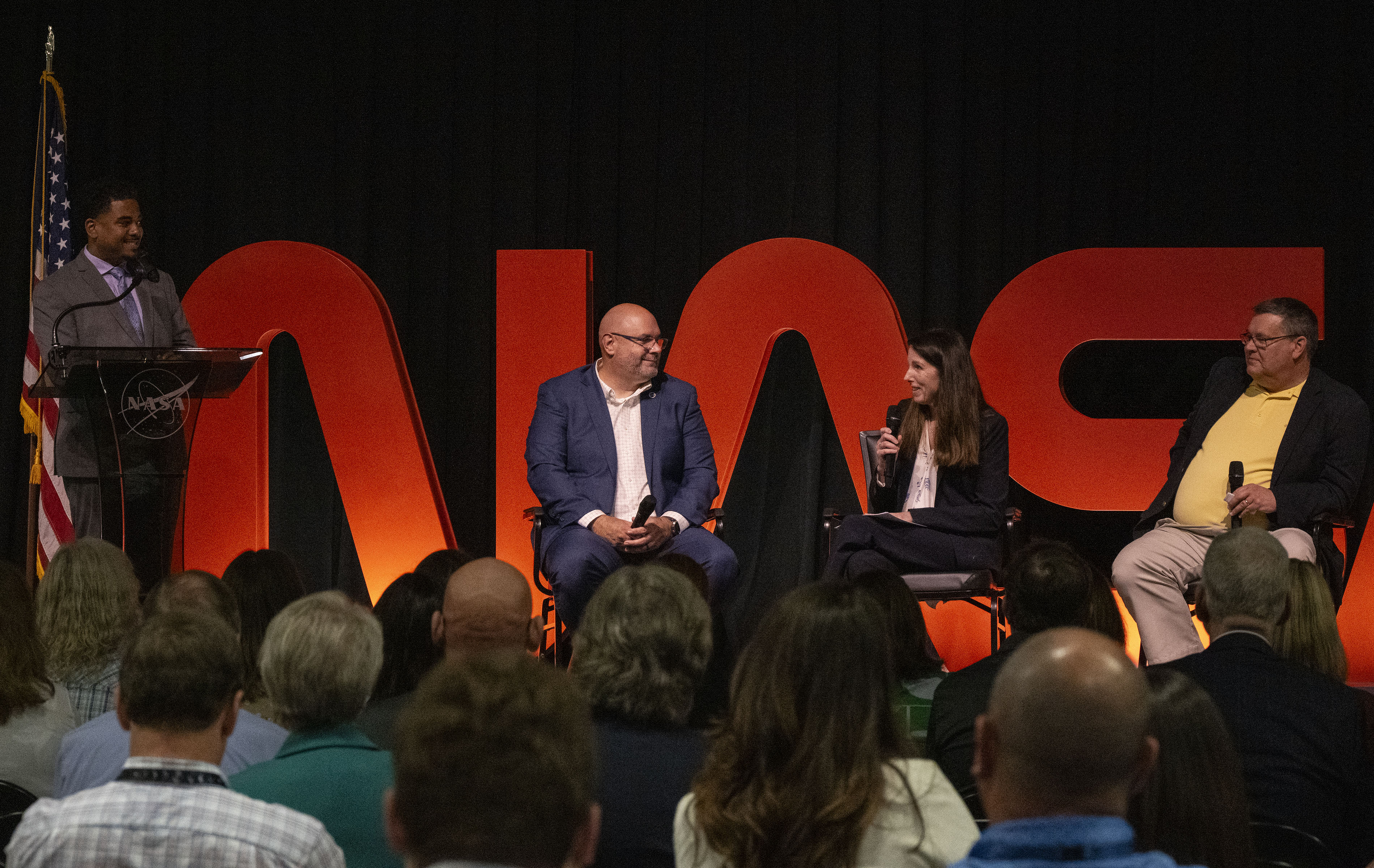
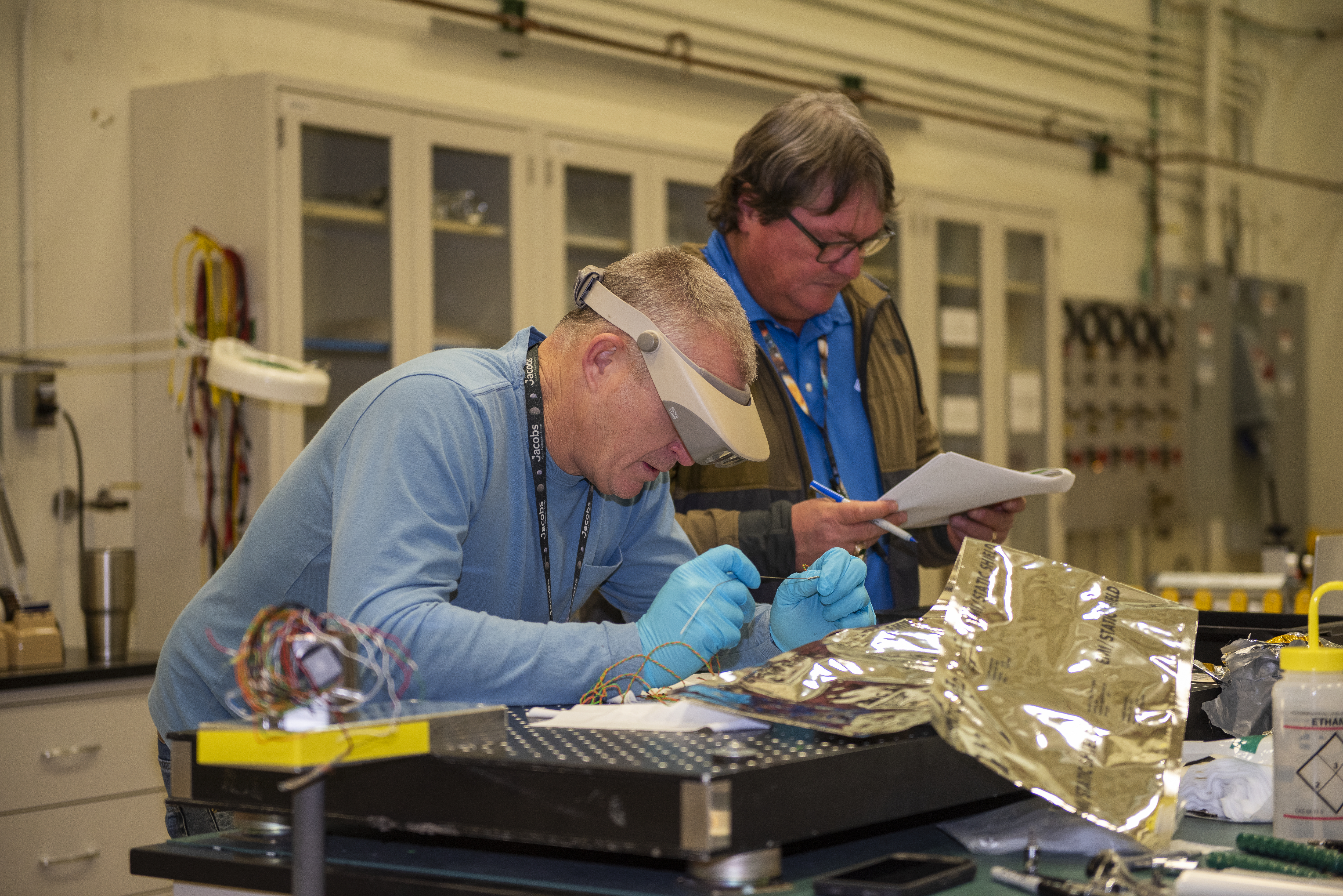
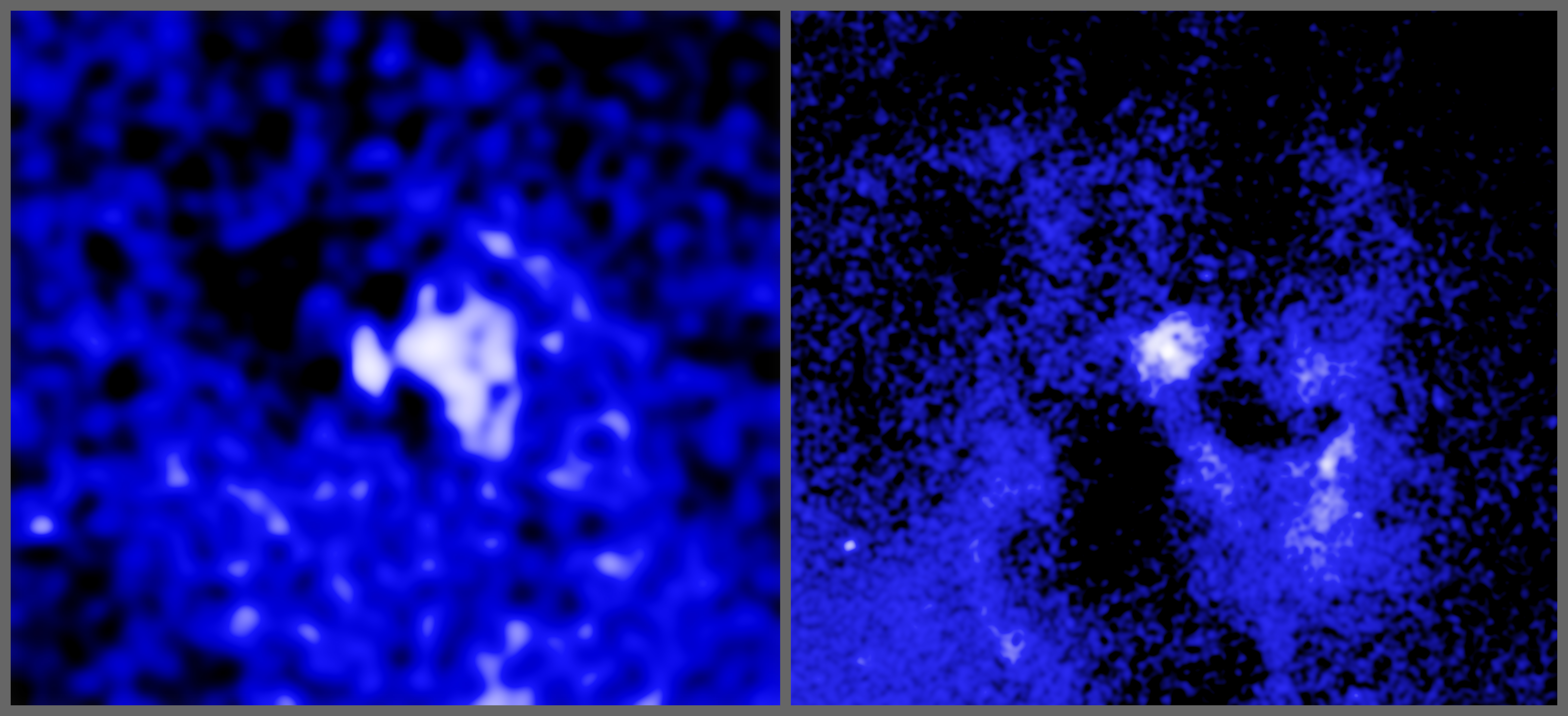
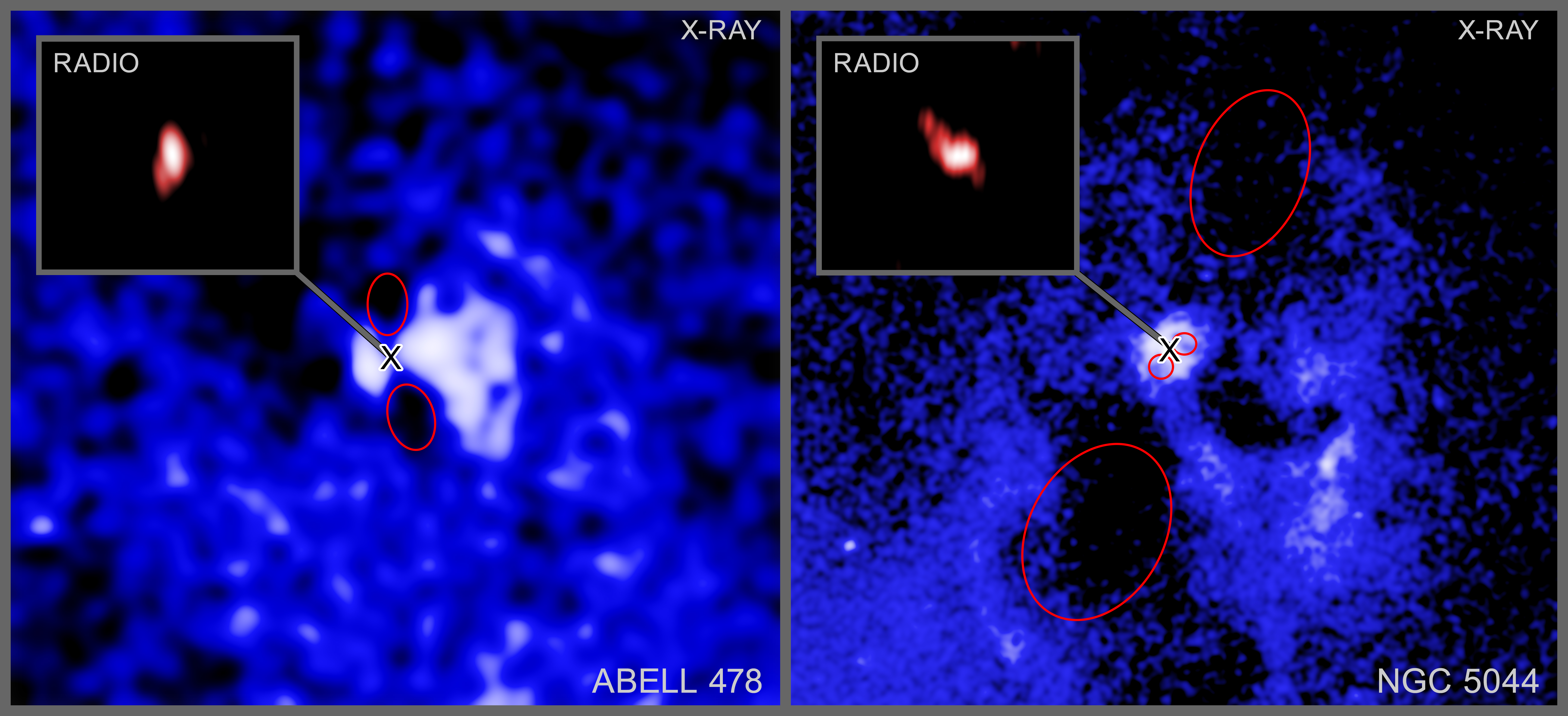
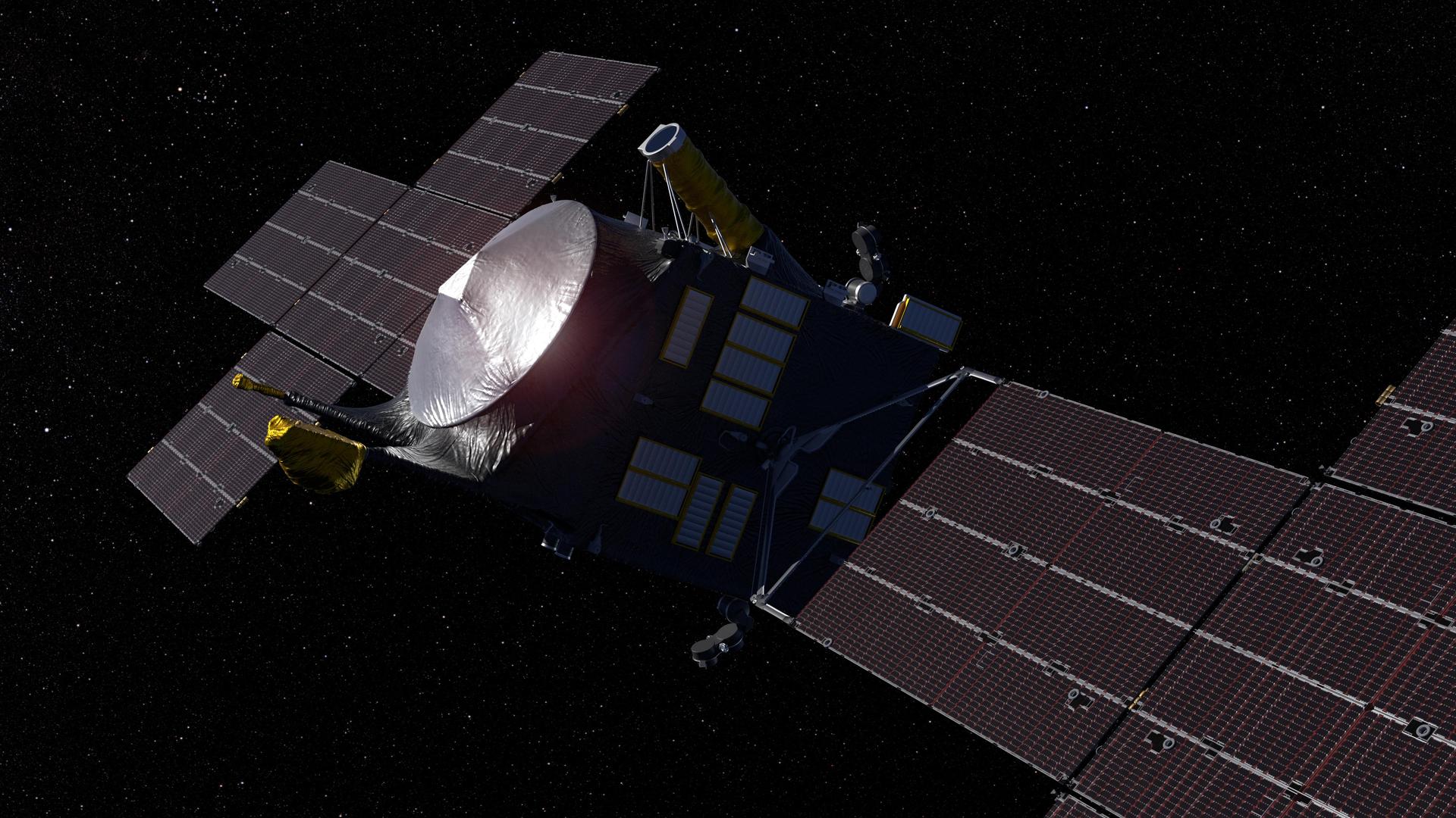
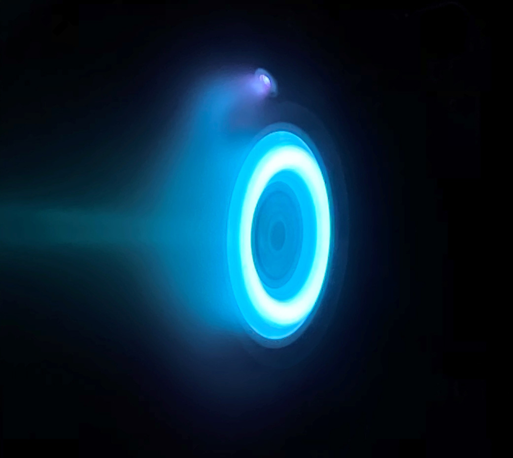
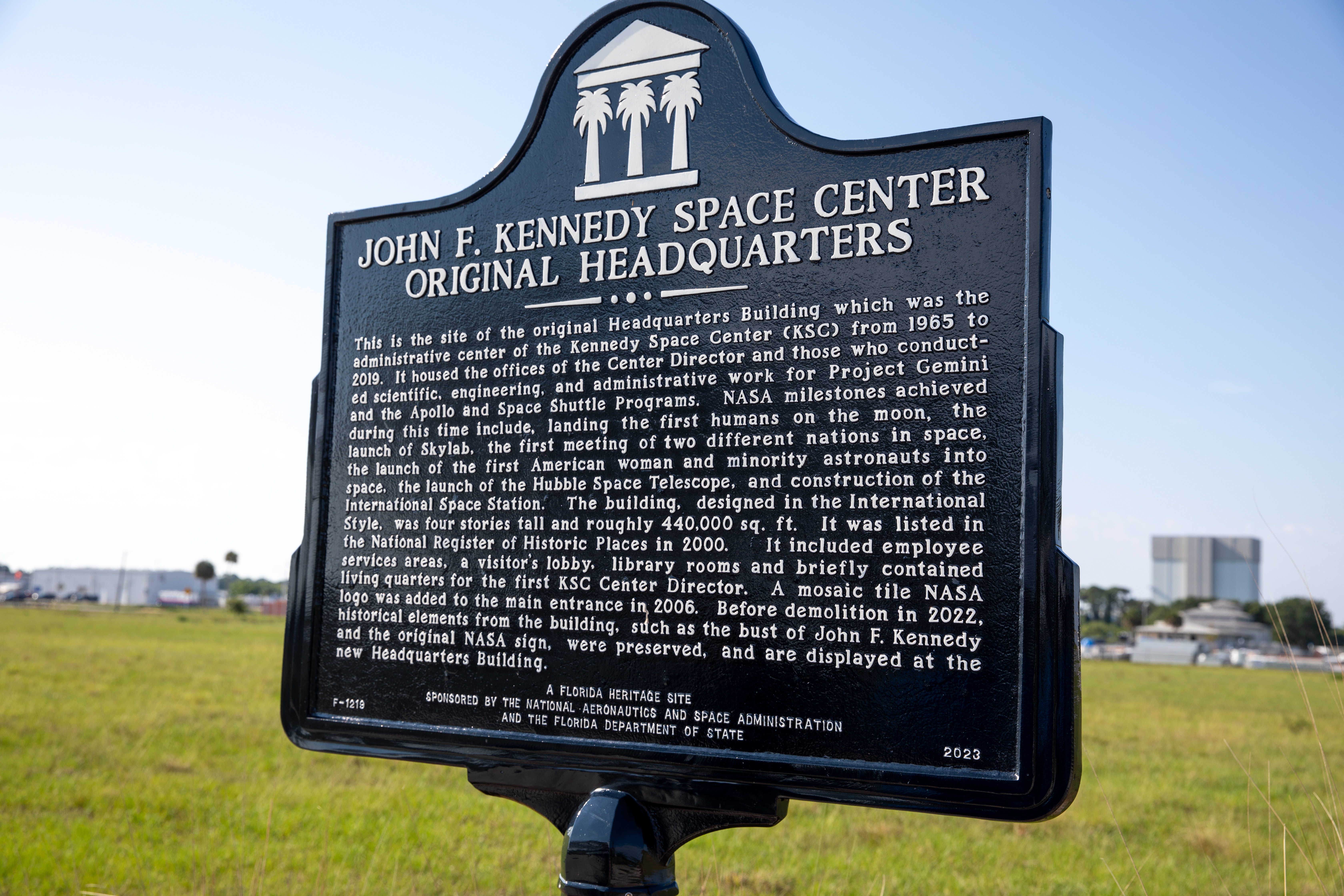
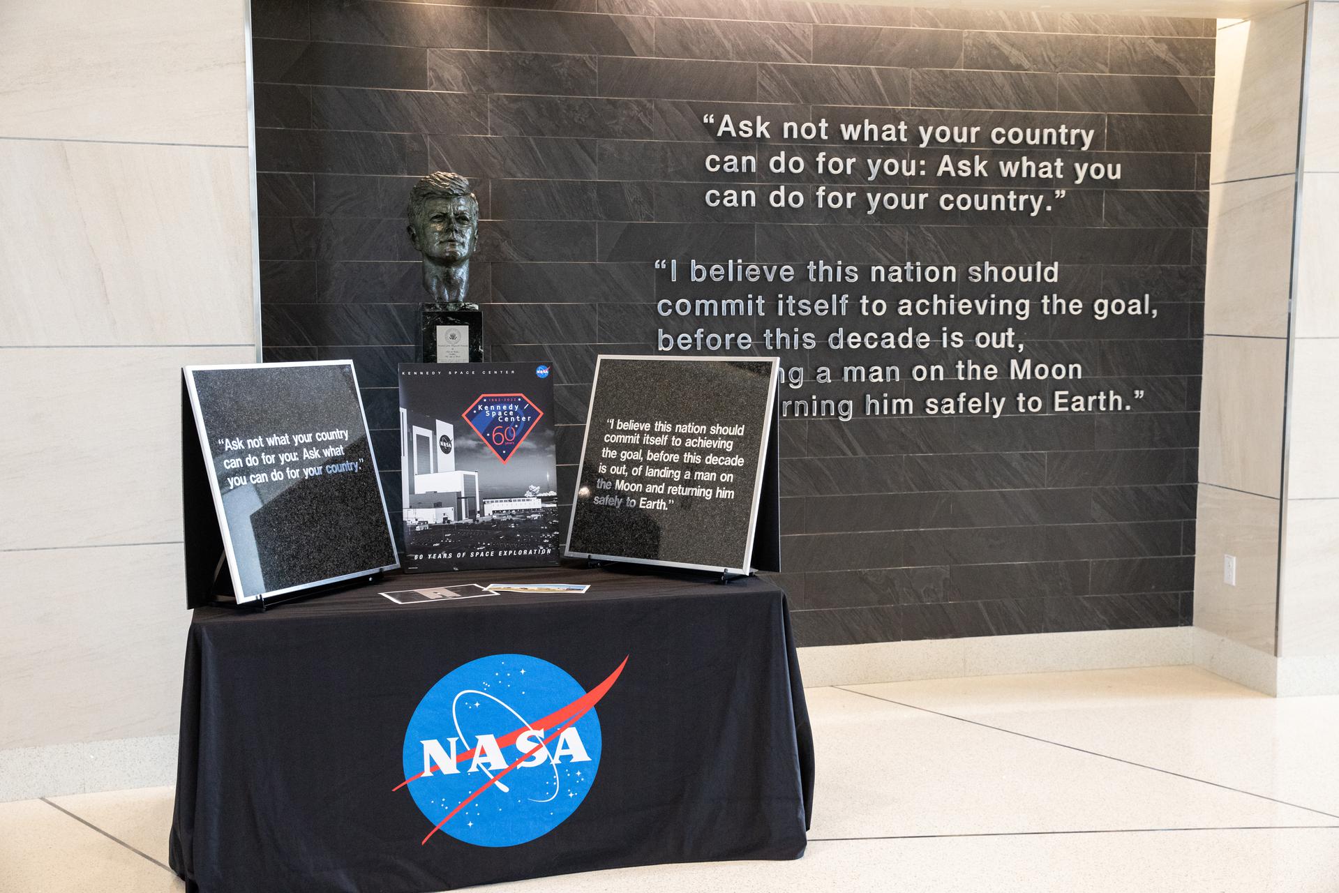
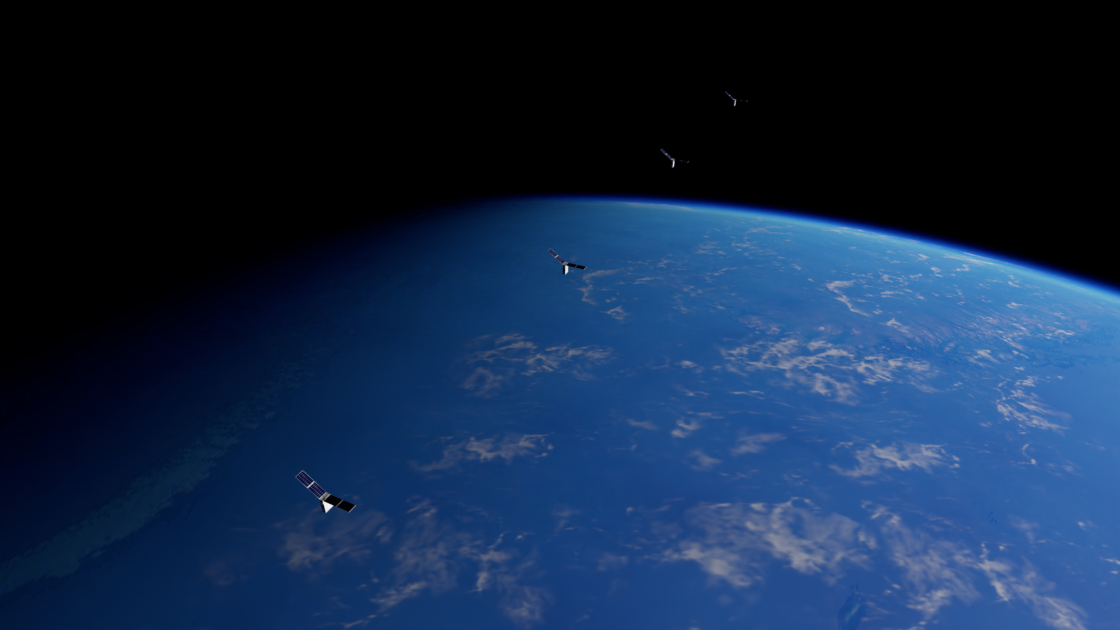
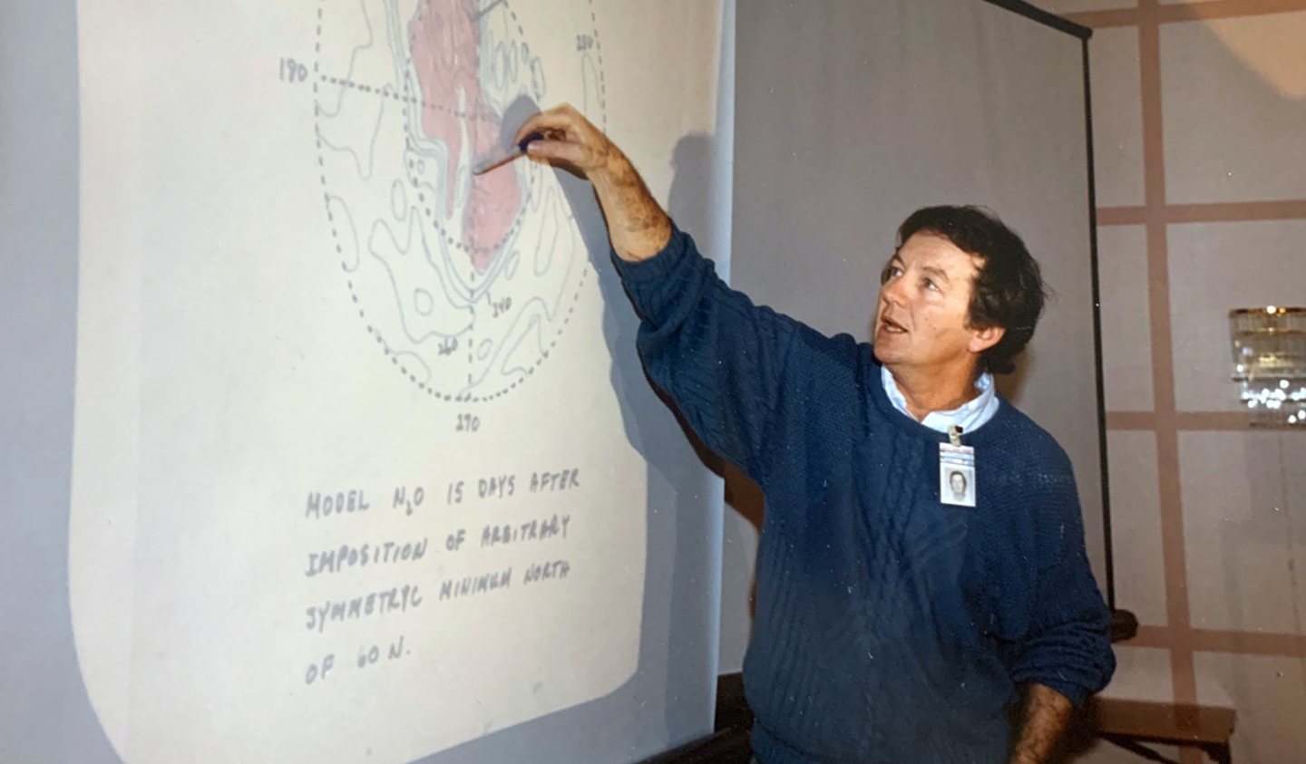
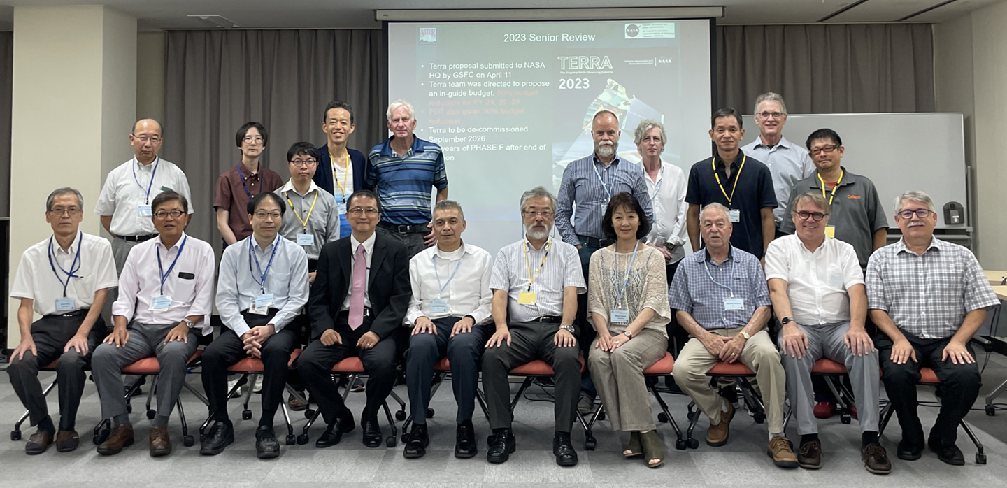
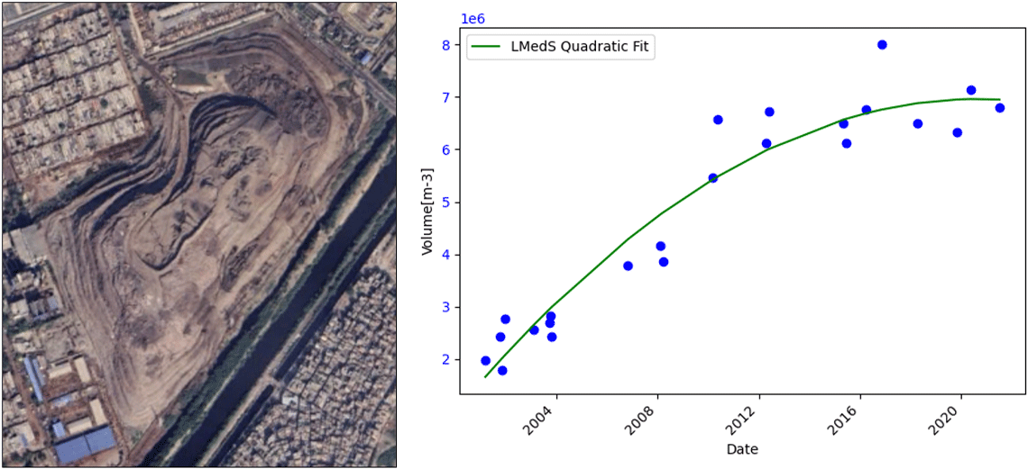
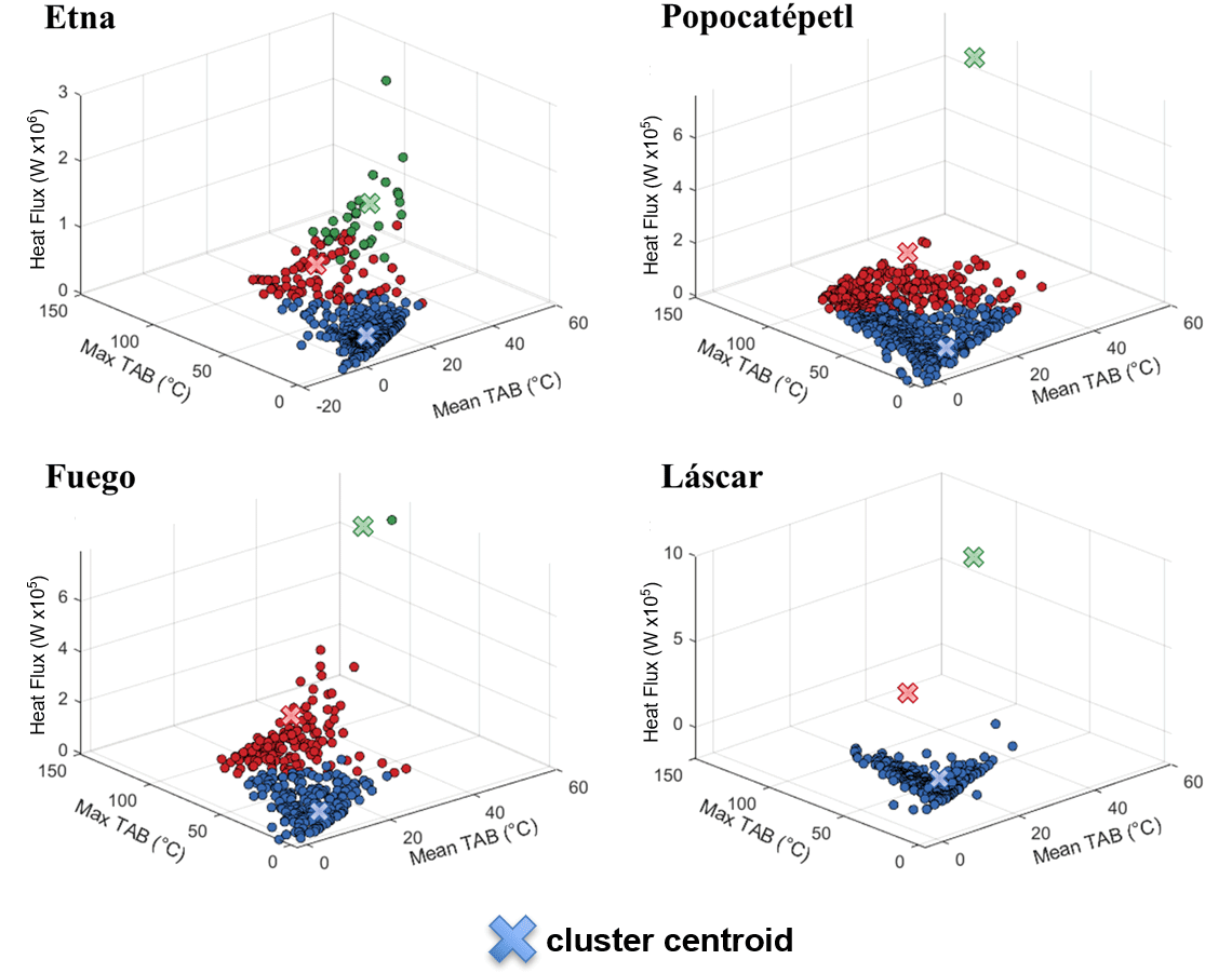
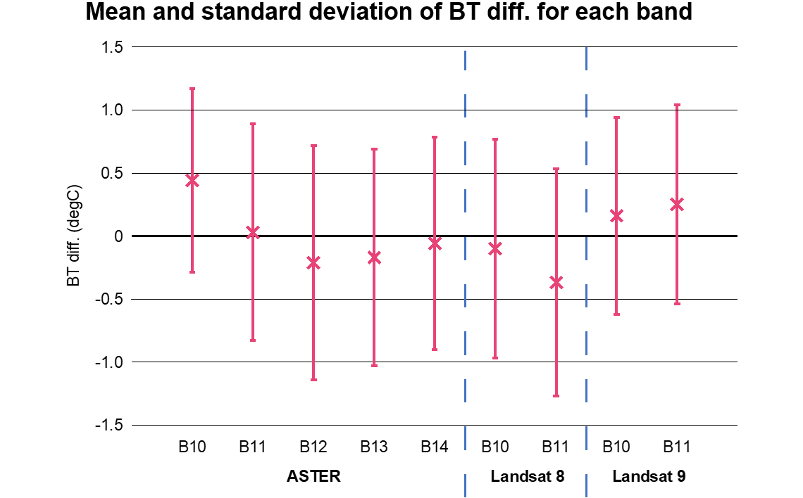
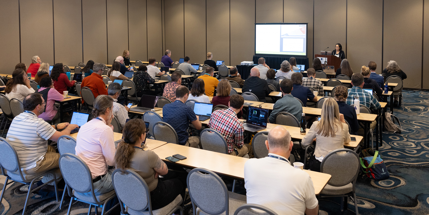
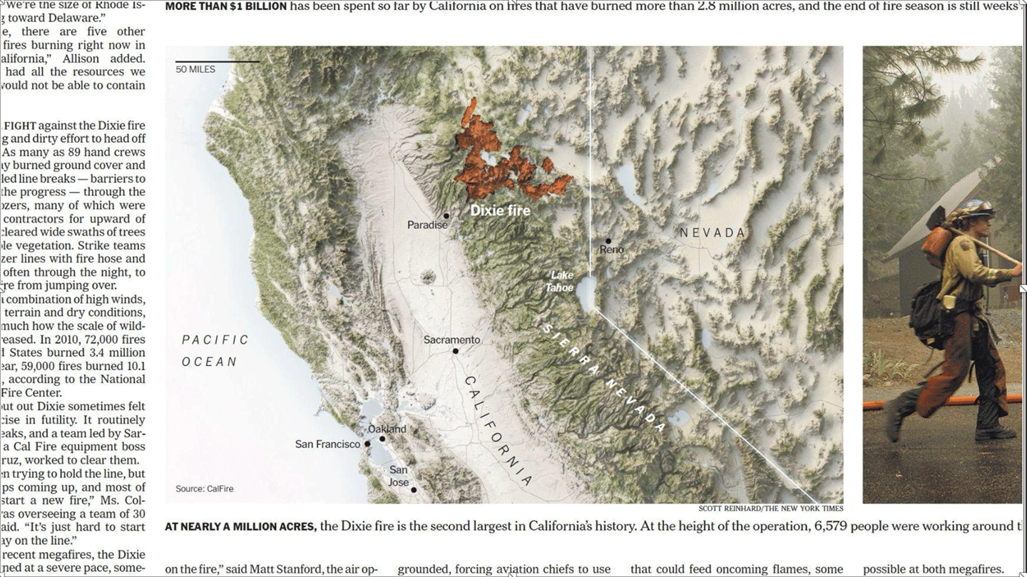
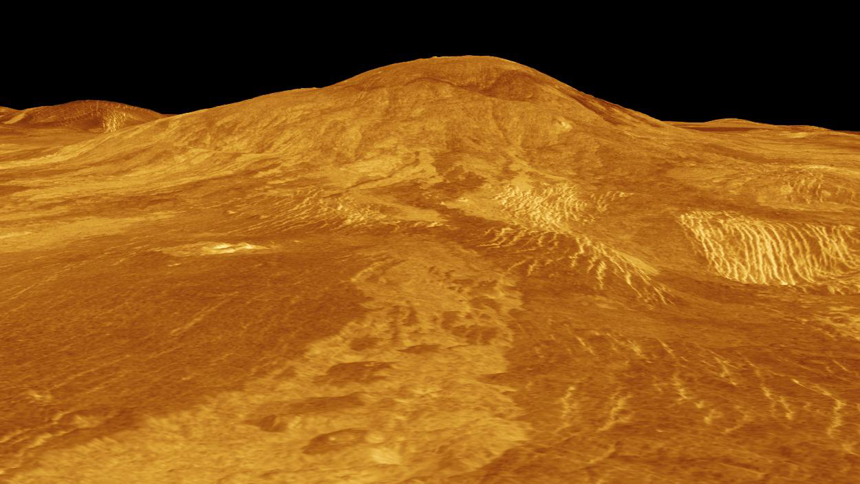
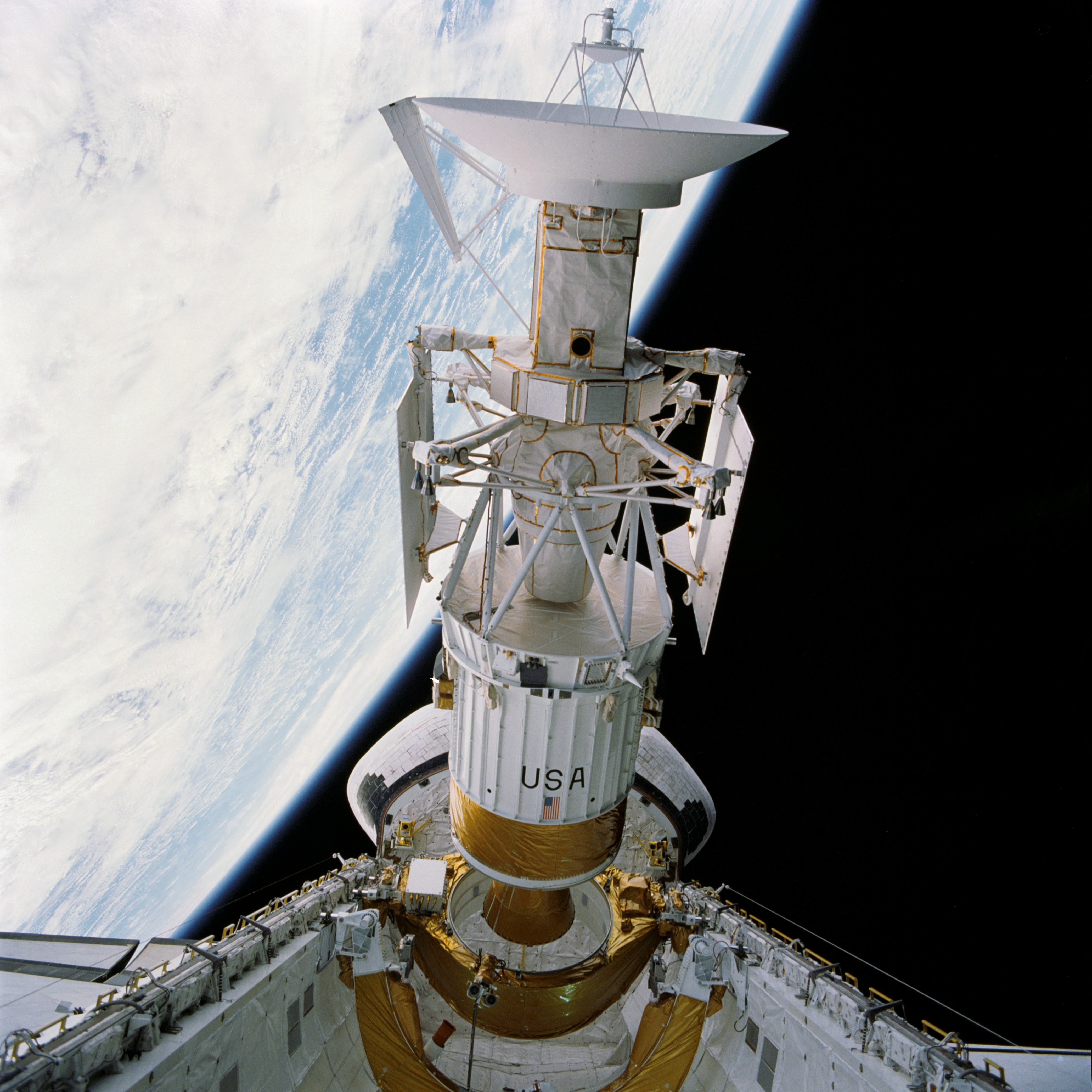