
NASA - Breaking News
June 2026 Satellite Puzzler
- Earth
- Earth Observatory
- Image of the Day
- EO Explorer
- Topics
- More Content
- About
NASA Knows: What Is Mass Distribution?
This article is for students grades 5-8.
Mass distribution affects everything from galaxy shapes to aircraft design to planetary rotation. It’s used to map stars in our universe, figure out what planets are made of, and even to determine how luggage is loaded onto an airplane.
Mass distribution can be a tricky thing to understand. So, let’s explore it using an everyday example: a soccer ball.
How Does Mass Distribution Affect Center of Mass?Have you ever kicked a soccer ball and wondered why it curves, spins, or sometimes wobbles? Mass distribution plays a part.
On the outside, soccer balls look simple – a series of geometric shapes woven together in a pattern. But on the inside, they are carefully engineered. The key to a great soccer ball is something you can’t see: how the mass is distributed inside the ball.
When engineers build a soccer ball, they try to make sure its mass is evenly balanced in all areas. This is because the way a ball spins and flies depends on how its mass is arranged. If one part of the ball is slightly heavier, its center of mass shifts. If the ball’s center of mass isn’t precisely balanced, the ball won’t move smoothly.
______________________________________________________________________
Words to Know
mass: the measurement of the amount of matter in an object
mass distribution: how mass is spread within an object
center of mass: the unique point around which the mass of an object is perfectly balanced
______________________________________________________________________
How Is Mass Distribution Measured?Scientists and engineers use tools like precision scales, computer models, and repeated testing to determine an object’s mass distribution. These efforts help them design balanced airplanes, rockets, and even soccer balls. Their goal is to achieve dynamic balance, meaning the object can travel smoothly without unexpected movements.
How Does Gravity Affect How We Study Mass Distribution?On Earth, gravity hides some of the details about how objects move. In microgravity, astronauts can observe motion more clearly. In 2019, Adidas partnered with NASA and sent soccer balls to the International Space Station.
Astronauts conducted tests to help engineers confirm their designs and understand the physics behind ball motion in ways they simply can’t on Earth. The results of the space station experiments have already helped improve the accuracy and consistency of modern soccer balls.
Try It YourselfYou don’t need to go to space to explore the physics of a ball in motion. Try this experiment at home or school:
- Grab different types of sports balls (soccer ball, basketball, tennis ball)
- Spin each one on the ground or between your hands
- Watch for wobbling, flipping, or smooth spinning
Can you tell which balls are well balanced? Or which ones might have uneven mass distribution?
Career CornerAre you interested in a career that explores the science and engineering of mass distribution? Many different occupations can help you strike the perfect balance. Here are a few examples:
Computer-Aided Design (CAD) Technician/Drafter: These specialists convert sketches and engineering designs into technical drawings. They use powerful computer software to create detailed 3D and 2D drawings of objects. A two-year associate degree from a technical or community college is key to this career path.
Computational fluid dynamics engineer: These engineers use computer simulation tools to model and analyze fluid behavior in real-world situations. They might study airflow around sport ball designs or explore ways to improve aircraft wings. They need a strong background in engineering and the ability to analyze complex problems.
Physicist: These scientists study matter and energy. They develop models and theories to explain how things work, conduct experiments, and use math to better understand the universe. A career in physics demands a strong understanding of math and complex problem-solving and usually requires an advanced college degree.
More to Explore:San Francisco’s Metropolitan Mosaic
- Earth
- Earth Observatory
- Image of the Day
- EO Explorer
- Topics
- More Content
- About
How NASA Science and Artemis Are Shaping the 2026 FIFA World Cup
As the FIFA World Cup approaches, NASA is bringing space science and engineering to soccer fans worldwide. From June 11 to July 19, 2026, NASA will host an exhibit at FIFA Fan Festival™ Houston where visitors can learn how research aboard the International Space Station benefits life on Earth and experience missions in low Earth orbit, the Moon, and beyond through the Artemis program.
On June 11, as the FIFA World Cup begins, NASA’s exhibit at Fan Festival Houston will open to the public. The event is free to attend and open for every match of the tournament in East Downtown, Houston. On June 20, Johnson Space Center Director Vanessa Wyche will introduce select Artemis II crew members following their historic mission around the Moon. The crew will participate in World Cup activities ahead of the Netherlands-Sweden match in Houston and will appear on the Fan Festival Houston main stage to share their experience with fans.
The connection between NASA and the World Cup goes beyond the exhibit floor, reaching all the way to orbit. NASA spinoff technologies are innovations developed for space exploration that go on to shape commercial products and everyday life – even on the soccer field.
For more than 25 years, research aboard the International Space Station has enabled breakthroughs in science, technology, and human health while advancing innovations that benefit people on Earth. That work includes studies that improve understanding of the aerodynamics and physics involved in soccer ball flight.
In partnership with the ISS National Laboratory in 2019, researchers used the station’s microgravity environment to study how a soccer ball’s internal mass affects its motion, stability, and rotation. The findings have improved understanding of how embedded technologies, including match-ball sensors, can influence performance during play. The research contributed to studies used in the development and evaluation of soccer balls for major international tournaments, including FIFA World Cup competition.
Understanding the relationship between an object’s center of mass and its geometric center is key to predicting how free-flying objects move, including spacecraft, satellites, and aircraft.
Since 2022, Adidas has embedded electronics inside official match balls used in major tournaments. The sensors track speed, position, and contact in real time to support officiating and broadcast technology. But those sensors also add mass in specific locations inside the ball, and uneven mass distribution can affect how a ball moves through the air.
The space-based research has helped improve understanding of how internal mass, including embedded sensors, can influence stability and rotation in real-world playing conditions.
This work builds on earlier research into how spinning objects behave in microgravity.
Engineers at NASA’s Ames Research Center in Silicon Valley, California tested Adidas’ Brazuca ball, developed for the 2014 FIFA World Cup, in wind tunnel conditions at the Fluid Mechanics Laboratory. Researchers studied aerodynamic behavior, including how low-spin kicks can produce “knuckling,” where the ball moves unpredictably due to unstable airflow across the seams. NASA engineers measured the speeds and flow conditions where this effect was most pronounced.
Adjustments in panel shape, seam depth, and surface texture can influence flight consistency, helping determine whether a ball curves, dips, or holds its line during play.
Now, NASA and Adidas are presenting that science through a STEMonstration that compares how differently balanced soccer balls spin and move in microgravity. The experiment shows how the same physics that governs motion in space also shape the game millions watch on Earth.
Through research aboard the International Space Station and technology developed for exploration, NASA continues to demonstrate how discoveries made for space can benefit people on Earth—including athletes and fans participating in the world’s most popular sport.
Watch the soccer ball STEMonstration video:
Explore More 3 min read San Francisco’s Metropolitan MosaicUrban development, green spaces, and maritime activity converge in this Northern California city.
Article 20 hours ago 6 min read Spacewalking With Scott Wray, Artemis EVA Training Lead Article 1 week ago 5 min read NASA Uses Mineralogical Marker to Understand Ancient Martian ClimateScientists analyzed 20 Martian samples collected by NASA’s Curiosity Rover and found that differences in…
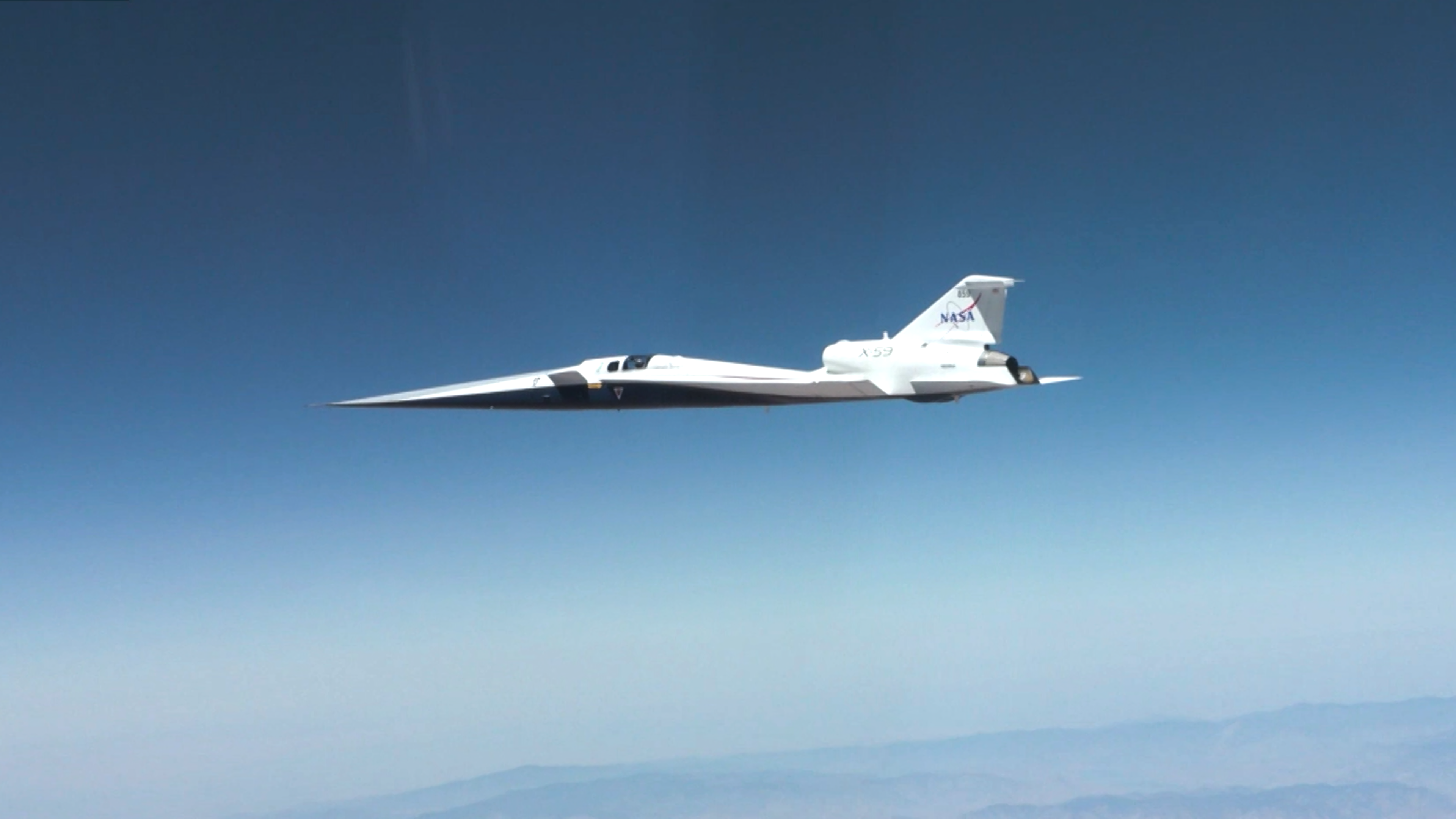
Article 2 weeks agoSupersonic!
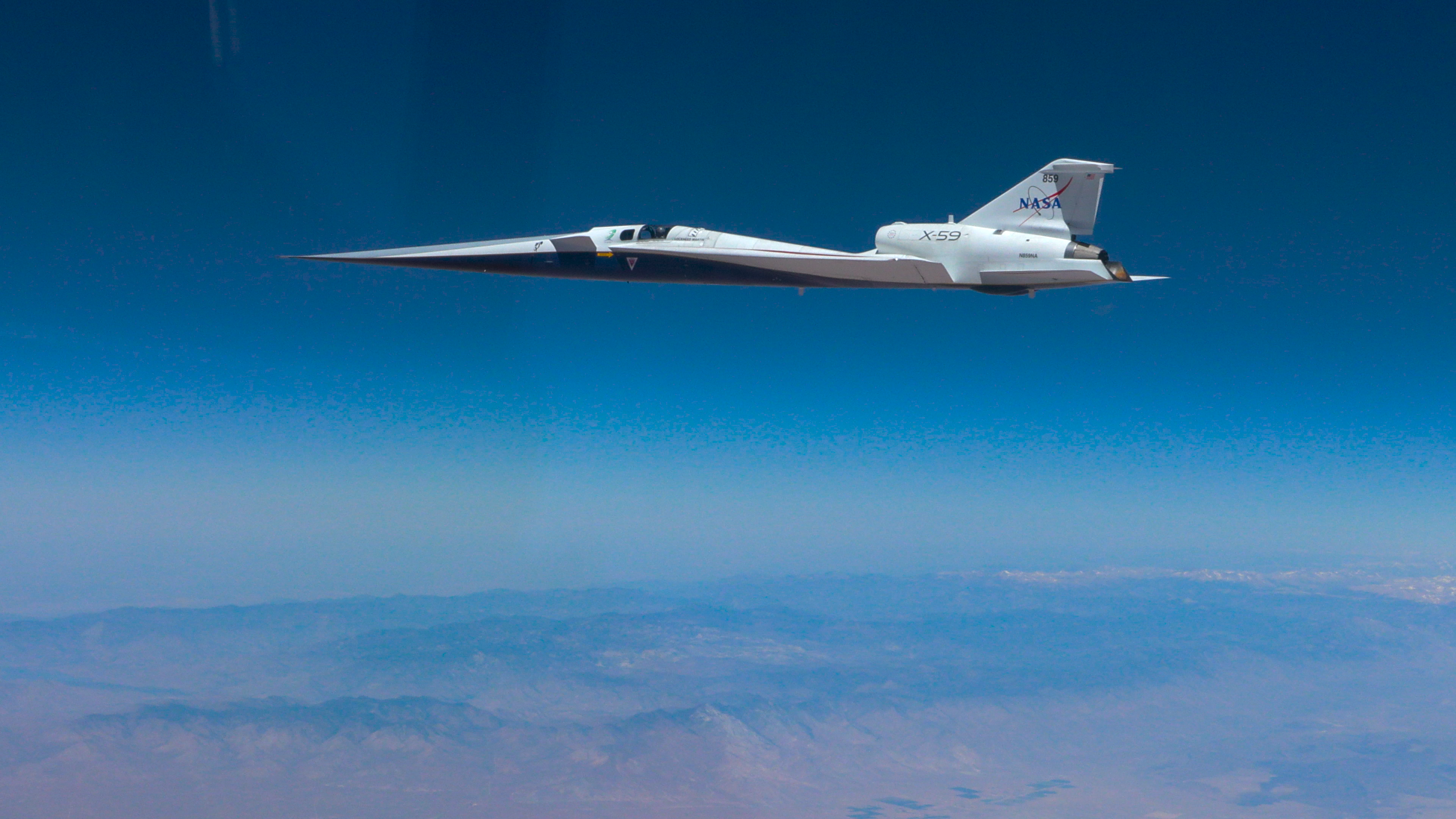
On June 5, 2026, NASA’s experimental X-59 aircraft flew faster than the speed of sound for the first time, setting the stage for demonstrating its quiet supersonic capabilities later this year. NASA test pilot Jim “Clue” Less took off and landed at Edwards Air Force Base in California, reaching a top speed of approximately Mach 1.1 (713 mph). The flight lasted 81 minutes, with the team focusing on flying qualities at both subsonic and then supersonic speeds.
The X-59 is the centerpiece of NASA’s Quesst mission, which aims to demonstrate quiet supersonic flight and help enable commercial supersonic flight over land worldwide. These advancements will help travelers reach their preferred destinations faster, spending less time in the air.
Learn more about the milestone and Quesst.
Image credit: NASA/Lori Losey
NASA’s INCUS Satellites Progress Toward Launch
Blue Canyon Technologies Photojournal Navigation Downloads NASA’s INCUS Satellites Progress Toward Launch
JPEG (10.32 MB)
Description
One of the three satellites that make up NASA’s INCUS (Investigation of Convective Updrafts) mission sits on a fixture at the facilities of Blue Canyon Technologies in Lafayette, Colorado. The satellite completed testing in preparation for launch in late May 2026. The mission will make the first space-based survey of the dynamics of tropical convective storms.
The three nearly identical satellites will fly in tight coordination in low Earth orbit, with the first and second satellites separated by 30 seconds, and the second and third satellite separated by 90 seconds.
Each satellites carries a radar designed to observe the vertical motion of air and water — known as convective mass flux — as storms develop and evolve. The middle satellite will also carry a microwave radiometer.
The INCUS mission is set to launch in 2027 from NASA’s Wallops Flight Facility in Virginia.
Funded through the Earth Venture Mission-3 acquisition under NASA’s Earth System Science Pathfinder Program and led by principal investigator Sue van den Heever at Colorado State University in Fort Collins, INCUS is one of several missions fulfilling the clouds, convection, and precipitation requirements of NASA’s Earth System Observatory, a set of interconnected missions set to study our home planet’s dynamic natural systems and how they interact. The mission is also part of FALCON (Fleet for the Atmosphere Linking Commercial Observations with NASA), a fleet of atmosphere-observing satellites that will combine hardware contributions from NASA centers, universities, and commercial partners.
Keep Exploring Discover More Topics From Photojournal
Photojournal
Search Photojournal
Photojournal’s Latest Content
Feedback
Digging Back in Time in the UAE
- Earth
- Earth Observatory
- Image of the Day
- EO Explorer
- Topics
- More Content
- About
NASA’s X-59 Aircraft Flies Supersonic for First Time
4 min read
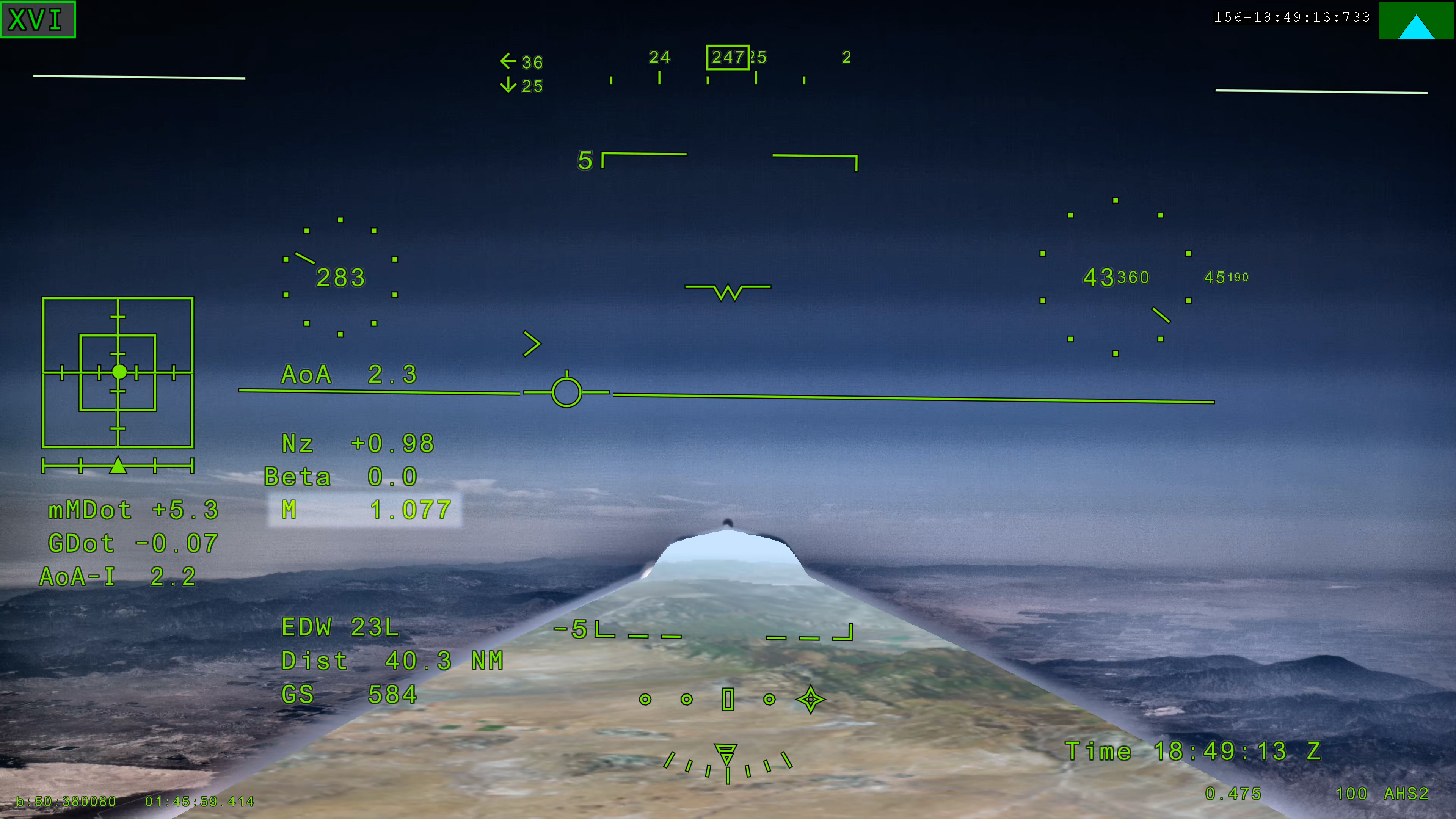
Preparations for Next Moonwalk Simulations Underway (and Underwater) NASA’s X 59 eXternal Vision System shows Mach 1.077 on Friday, June 5, 2026, marking the aircraft’s first time reaching supersonic speed in support of NASA’s Quesst mission. The moment represents a milestone for the aircraft as it transitions to include test flights faster than the speed of sound. NASANASA’s experimental X-59 aircraft marked a major milestone Friday, June 5, when it flew faster than the speed of sound for the first time, setting the stage for demonstrating its quiet supersonic capabilities later this year.
NASA test pilot Jim “Clue” Less took off and landed at Edwards Air Force Base in California, reaching a top speed of approximately Mach 1.1 (713 mph) and altitude of 43,400 feet. The X-59’s flight began at 11:08 a.m. PDT and lasted 81 minutes, with the team focusing on flying qualities at both subsonic and then supersonic speeds.
In the coming days, we expect to take the next step and push to Mach 1.4jared isaacman
NASA Administrator
”X-59 is getting ready for its quiet supersonic debut. Since the aircraft’s first flight on Oct. 28, 2025, the team has made tremendous progress, flying 16 times in the last 90 days and getting into a steady test rhythm. In the coming days, we expect to take the next step and push to Mach 1.4,” said NASA Administrator Jared Isaacman “I’m grateful to the NASA team and Lockheed Martin Skunk Works for their help getting us to this point, and I hope this is the first of many collaborations as we rebuild NASA’s X-plane portfolio.”
The X-59 is designed to fly at supersonic speeds while creating only a quiet thump instead of a loud sonic boom. For this flight, a NASA F‑15 chase plane flew nearby to monitor the X‑59. The loud sonic booms from the F-15 obscured any sound made by the X-59.
“The X-59’s first supersonic flight is a testament to America’s enduring leadership in science, engineering, and aerospace innovation,” said Michael Kratsios, Assistant to the President for Science and Technology and Director of the Office of Science and Technology Policy. “This achievement comes as the Trump Administration continues work to unleash supersonic flight and enable American ingenuity.”
This first supersonic flight is a significant milestone, but an event even more critical to the mission is upcoming. In just days, the aircraft is expected to make its first “mission conditions” flight, reaching a cruising speed of Mach 1.4 (925 mph) and altitude of approximately 55,000 feet. The X-59 also will be accompanied by a chase plane for this flight.
NASA’s X-59 quiet supersonic research aircraft completed its first supersonic flight Friday, June 5, 2026, marking the first time the aircraft exceeded the speed of sound in support of NASA’s Quesst mission. The milestone represents a major step in flight testing as the aircraft expands into the supersonic portion of its flight envelope. NASA / Lori LoseyThis speed and altitude are the base conditions for the X-59 when it will eventually fly over several U.S. communities enabling NASA to gather data about how people may perceive its quiet thump. NASA will share this data with U.S. and international regulators to help establish new data-driven noise standards to enable a future viable market for supersonic commercial flight over land.
For the last several months, the X-59 has been participating in an ongoing series of flights where the plane has been flying at a wide range of speeds and altitudes – a process known as envelope expansion. These tests are the first phase of the X-59’s flight testing. They are focused on performance and involve chase plane monitoring. When the aircraft completes this phase it will enter another, focused on its sound profile in order to verify its quiet thump capability.
The X-59 is the centerpiece of NASA’s Quesst mission, which aims to demonstrate quiet supersonic flight and help enable commercial supersonic flight over land worldwide. These advancements will help travelers reach their preferred destinations faster, spending less time in the air.
Through Quesst’s development of the X-59, NASA also will deliver design tools and technology for quiet supersonic airliners that will achieve the high speeds desired by commercial operators without disturbing people on the ground. NASA will validate design tools through ground and flight testing, providing U.S. aircraft manufacturers the ability to explore new quiet supersonic concepts, and provide them with confidence that their resulting designs will meet quiet flight requirements.
Read more about NASA’s Quesst mission and the X-59. Facebook logo @NASA@NASAaero@NASAes @NASA@NASAaero@NASA_es Instagram logo @NASA@NASAaero@NASA_es Linkedin logo @NASA Explore More 6 min read NASA’s X-59 Prepares for First Supersonic Flight Article 2 weeks ago 4 min read Keeping NASA Flying: Ground Crews Ensure Aircraft Readiness Article 2 weeks ago 4 min read NASA Announces Winners in University Aeronautics Competition Article 3 weeks ago Keep Exploring Discover More Topics From NASAMissions
Artemis
Aeronautics STEM
Explore NASA’s History
Share Details Last Updated Jun 08, 2026 EditorJim BankeContactMatt Kamletmatthew.r.kamlet@nasa.govKristen Hatfieldkristen.m.hatfield@nasa.govLocationArmstrong Flight Research Center Related TermsNASA Announces Winners of 2026 University Innovation Competition
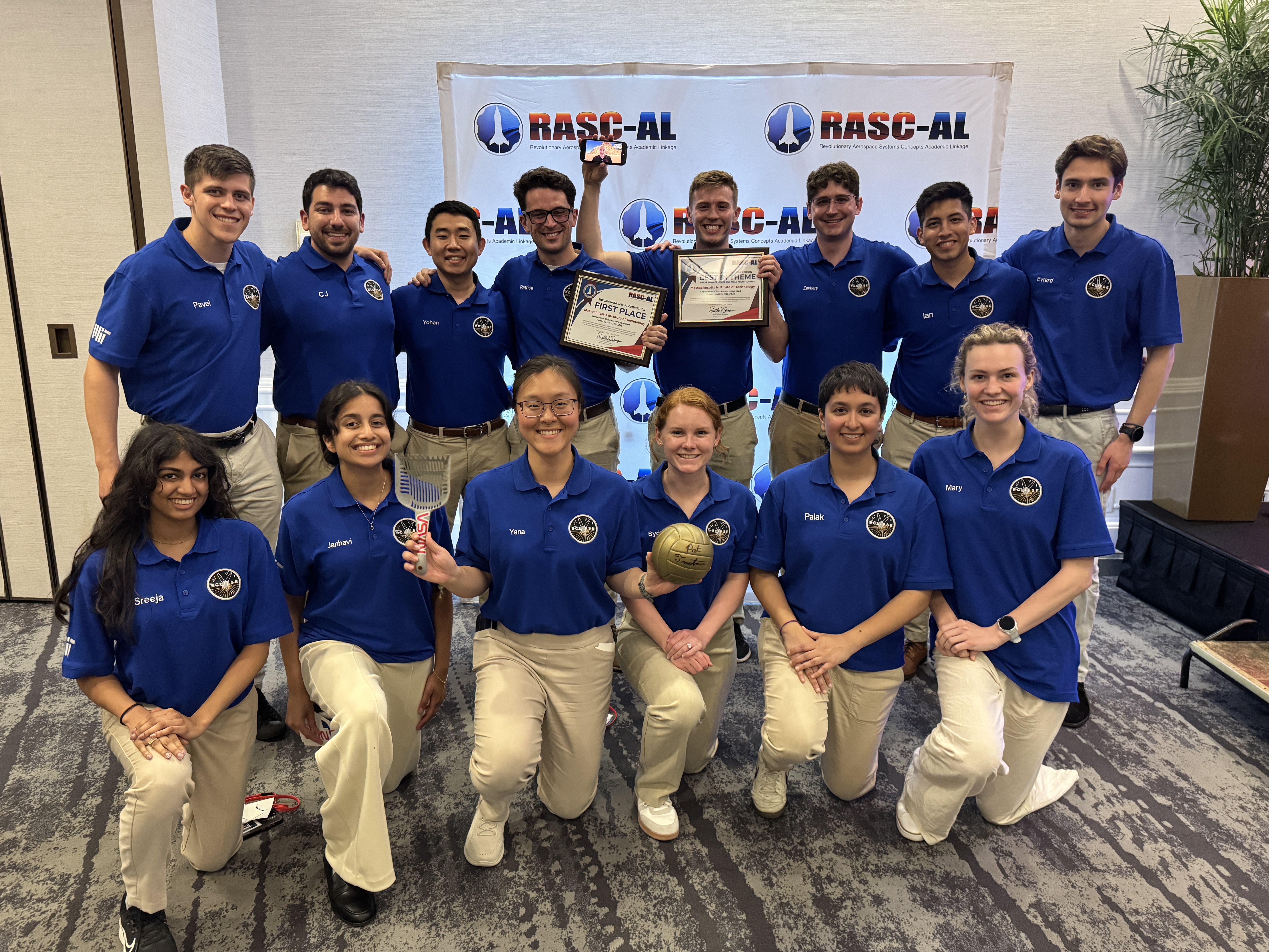
NASA announced the Massachusetts Institute of Technology project, Exploration-Class Lunar Integrated Power SystEm, as the first place winner for the 2026 Revolutionary Aerospace Systems Concepts – Academic Linkage (RASC-AL) competition, which challenges students to bridge gaps in aerospace technology by innovating new system concepts and prototypes.
Another team from the same university won second place overall for their project, Mars Exploration Layered Infrastructure for Operations, Research, and Advancement, while Virginia Polytechnic Institute and State University took third place with the Mars Pylon Network.
Empowering the next generation, the competition also supports the agency’s workforce development priorities by offering university teams hands-on experience in mission architecture development, systems engineering, and technical communication.
“The winning teams demonstrated how academic innovation can support Artemis mission goals,” said Daniel Mazanek, program sponsor for RASC-AL and senior space systems engineer, NASA’s Langley Research Center in Hampton, Virginia. “Their work highlights the important role student research plays in shaping future space exploration, and the results showcase how disciplined analysis can elevate innovative ideas into viable exploration concepts.”
Fourteen finalists attended the multi-day RASC-AL Forum in Cocoa Beach, Florida, and gave formal presentations outlining their mission architectures, technology solutions, and supporting analysis. These discussions provided students with real-time engineering feedback, exposing them to the rigor and scrutiny applied to human spaceflight concepts under development within the agency.
Awards were presented to teams demonstrating the highest levels of technical rigor, innovation, and mission alignment. In addition to the top prizes, other awards included:
- Best in Communications, Position, Navigation, and Time Architectures for Mars Surface Operations Theme: Massachusetts Institute of Technology
Mars Exploration Layered Infrastructure for Operations, Research, and Advancement MELIORA)
- Best in Lunar Sample Return Concept Theme: South Dakota State University
Sample Extraction of Lunar Elements for Network Entry (SELENE)
- Best in Lunar Surface Power and Power Management and Distribution Architectures Theme: Massachusetts Institute of Technology
Exploration-Class Lunar Integrated Power SystEm (ECLIPSE)
- Best in Lunar Technology Demonstrations Leveraging Common Infrastructure Theme: Massachusetts Institute of Technology
CLPS-enabled Highly-autonomous End-to-End isruSystem Evaluations to Build Understanding and Resilient Growth by Experimenting with Regolith (CHEESEBURGER)
- Best Prototype:
Embry-Riddle Aeronautical University, Worldwide Campus
Advanced Utilization of Resources for Energy & Viability Off-Earth (Project AUREVO)
University of Illinois, Urbana-Champaign with Leonardo de Vinci Engineering School
Mining and Advanced Transformation of Regolith for Infrastructure and eXpansion (MATRIX)
“The RASC-AL program allows students to demonstrate their ability to transform innovative concepts into technically sound studies, with emphasis on technical rigor, clear communication, and systems-level thinking,” said Christopher Jones, program sponsor for RASC-AL and chief technologist for the Systems Analysis and Concepts Directorate at NASA Langley. “These are the hallmarks of effective engineering that we’re looking for and reflect the standards required for real-world aerospace problem-solving,”
The NASA RASC-AL competition represents a cross-agency collaboration. The competition is administered by the National Institute of Aerospace and managed by the NASA Tournament Lab, part of the agency’s Prizes, Challenges, and Crowdsourcing Program.
For more information, visit:
NASA’s Artemis II Moon Mission Research Continues on Earth
5 min read
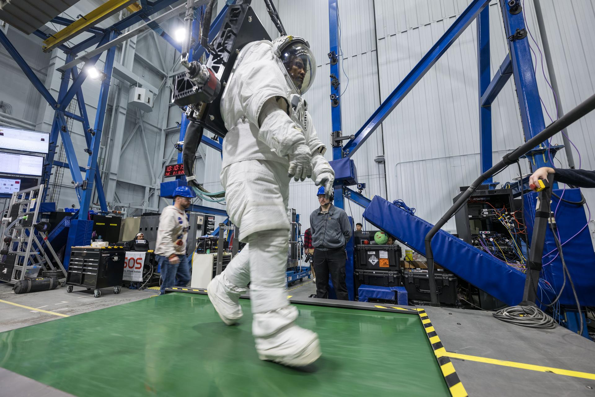
NASA’s Artemis II Moon Mission Research Continues on Earth Artemis II astronaut Victor Glover walks on a treadmill while in a space suit harnessed to NASA’s Active Response Gravity Offload System at NASA’s Johnson Space Center. Glover is simulating a walk on a planetary surface while in a suit that has been offloaded to lunar gravity. Artemis II astronauts completed this and other suited tasks before their mission launched and within a few days of landing, giving researchers a chance to assess how quickly upon landing crews’ bodies adapt to a different gravity. Results will help scientists better understand how soon after landing crews can complete mission-critical tasks on the surface of the Moon or Mars. NASA/Robert MarkowitzSince NASA’s Artemis II crew members safely splashed down in the Pacific Ocean on April 10 after their record-setting mission around the Moon, science teams have been busy collecting more data and combing through observations collected on the test flight. Results from these science investigations will help support safe human exploration of deep space and provide a blueprint for how future missions will conduct science on the lunar surface as NASA builds a Moon Base and develops an enduring human presence there.
Postflight crew health, performance dataIn the hours, days, and weeks after landing, the Artemis II crew members, NASA astronauts Reid Wiseman, Victor Glover, Christina Koch, and CSA (Canadian Space Agency) astronaut Jeremy Hansen, contributed critical data to help the agency understand how the human body reacts to spaceflight. Collecting this data as soon as possible after landing was important to understand how the body adapts from microgravity to Earth’s gravity. The data will inform NASA’s understanding of how quickly crews can complete mission-critical tasks after landing on a planetary surface like the Moon or Mars, where there won’t be landing support personnel to assist.
Within a day of splashdown, researchers collected a suite of data for the Artemis II Spaceflight Standard Measures study, which is part of a larger effort across the astronaut corps to gather a baseline set of health measurements on blood pressure, heart rate, eye health, and motor control. Crew members also completed a mini obstacle course, which included lying down, standing up, unfurling a rope ladder, ladder climbing, and more, to assess how their bodies were adapting to Earth’s gravity.
Once the crew returned to NASA’s Johnson Space Center in Houston, researchers guided them through further medical check-ups and tests of motor control. Over the next several days, the crew completed obstacle courses wearing spacesuits offloaded to lunar gravity, which is roughly one-sixth the force of Earth’s gravity. Researchers are now analyzing this data to gain insight into how crews may perform as they adapt to the gravity of a planetary surface.
As part of the Immune Biomarkers study, researchers are comparing blood and saliva samples collected after the Artemis II splashdown with samples collected preflight and during the mission. Among other topics, the study investigates whether and how dormant viruses reawaken in astronauts’ bodies while in space.
Some crew members completed postflight cognition tests and a simulated manual spacecraft docking task to assess motor control for the ARCHeR (Artemis Research for Crew Health & Readiness) study. This, combined with data collected through a wrist-worn device while crew members were in space, is used to understand the effect of space hazards on well-being and performance.
Initial data collections for Artemis II health studies concluded 45 days after splashdown. However, medical teams will continually monitor astronaut health throughout the Artemis II crew members’ lifetimes.
Once this data is processed and anonymized, information will be available for scientists to study the effects of spaceflight via a request to NASA’s Life Sciences Data Archive. The results from this work could lead to new technologies and studies that help predict the adaptability of crews on future missions to the Moon and Mars.
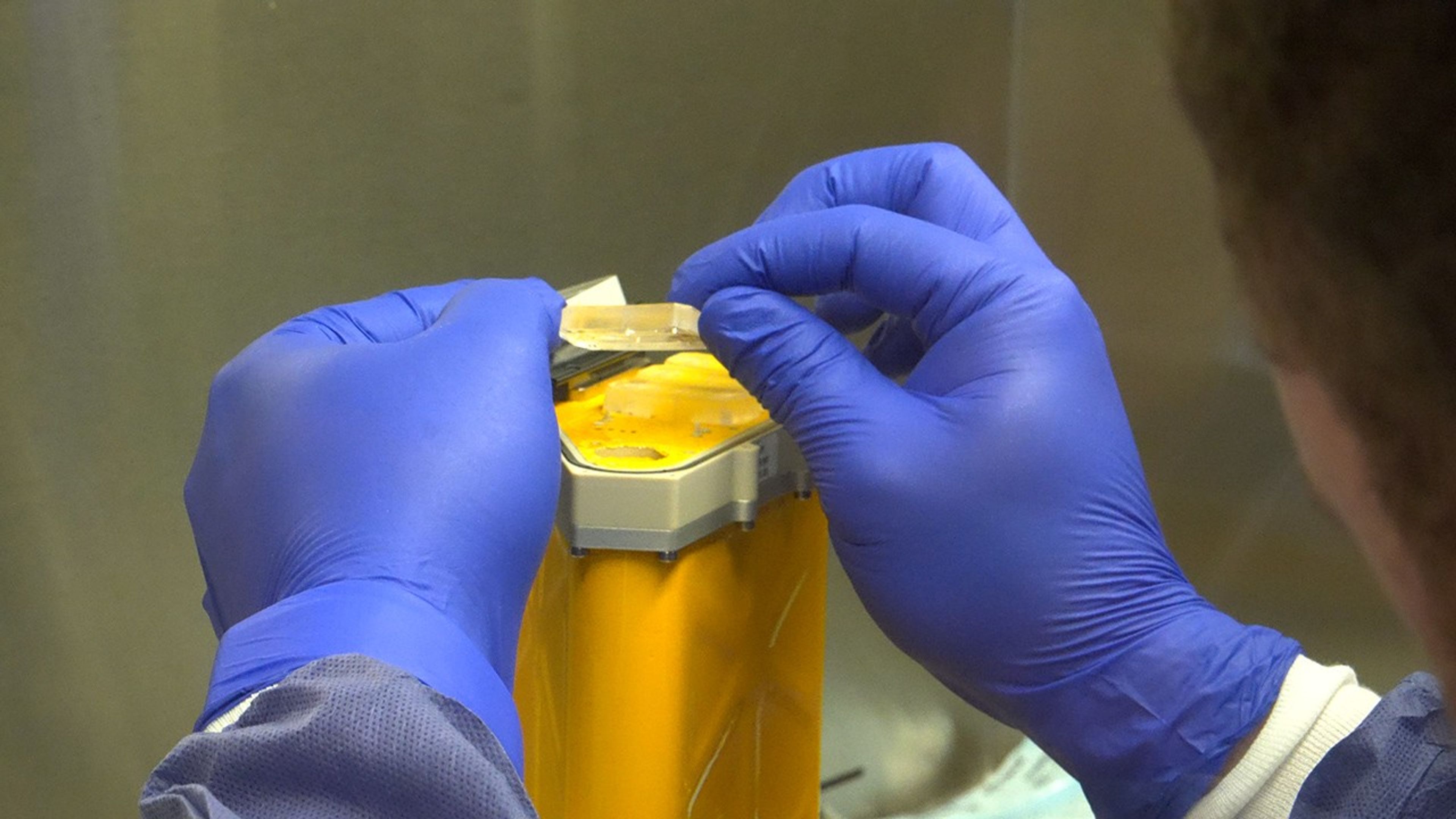
Analyzing astronaut-derived organ chips flown around Moon A scientist handles AVATAR organ chips following their journey around the Moon aboard Orion. The chips contain cells from each astronaut and are being prepared for detailed analysis. NASAOrgan chips from NASA’s AVATAR (A Virtual Astronaut Tissue Analog Response) investigation are being analyzed at chip developer Emulate’s laboratory in Boston. The organ chips included bone marrow cells from each Artemis II astronaut. They flew around the Moon with the astronauts, and now researchers are studying these organ chips to determine how deep space radiation and microgravity affect human health at the molecular level.
Scientists are comparing the chips flown aboard the spacecraft to ground controls and crew blood samples using advanced techniques, including single-cell RNA sequencing. The analysis will characterize how organ chips model individual responses to spaceflight, which is data that could allow NASA to send future astronauts’ AVATAR chips ahead on missions to develop personalized medical kits. The researchers plan to share early findings at scientific conferences while full analysis continues.
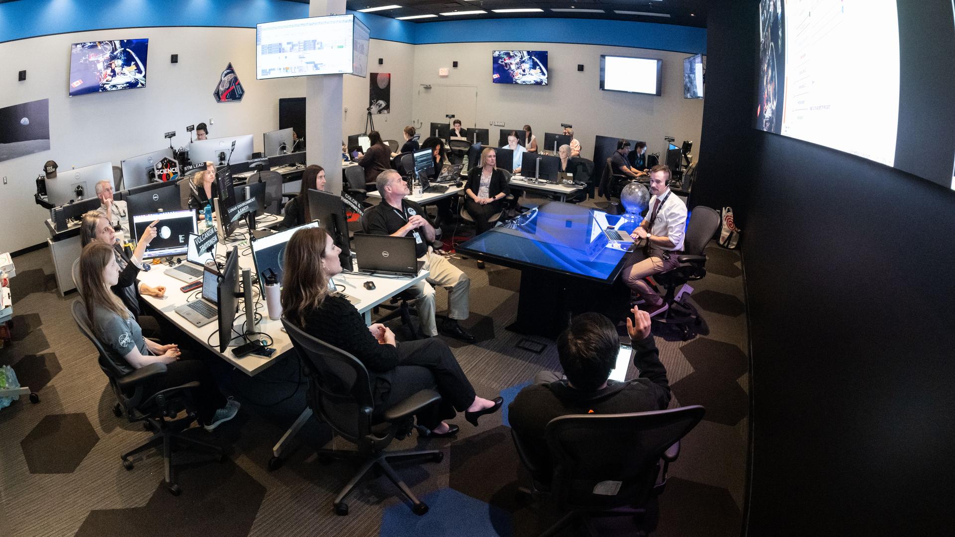
Lunar imagery, audio for data release In this April 3, 2026, image, the Artemis II lunar science team is shown working in the Science Evaluation Room in the Mission Control Center at NASA’s Johnson Space Center in Houston. The team is putting together a plan of science observations for the Artemis II crew, which was headed toward the Moon aboard Orion. As they passed the Moon at closest approach on April 6, the crew applied the geology skills they learned in the classroom and in Moon-like environments on Earth as they photographed and described nuances of geologic features such as impact craters, ancient lava flows, and surface cracks and ridges. The crew noted differences in color, brightness, and texture — details that provide clues to surface composition and history. NASA/Bill StaffordOn April 6, the Artemis II crew members studied features on and around the Moon for nearly seven hours during Orion’s closest approach to the lunar surface. Their work was guided by a minute-by-minute observation plan developed by the Artemis II lunar science team.
Scientists are reviewing the data collected from the mission, which includes images, video, and audio files, to release a report of their initial data interpretations later this year. The report will cover observations of impact flashes, variations in color on the lunar surface, and the shape and texture of faults and ridges. The team also will publish a report on how Artemis II lunar science observations were planned, organized, and executed for the benefit of future Artemis missions.
NASA will publish more than 100 science-related audio recordings with transcripts, as well as approximately 11,500 Earth and Moon image and video files from the mission science campaign, with accompanying data. While many of these images already are public, these records will be available through NASA’s Planetary Data System, a public archive of data from all of NASA’s planetary missions. To get the data ready, the team is converting files into standard formats that anyone can easily open and add information to make the data searchable in NASA’s archive for generations to come.
For more information on NASA’s Artemis II science efforts, visit:
https://www.nasa.gov/humans-in-space/artemis-ii-science/
Karen Fox / Molly Wasser
Headquarters, Washington
240-285-5155 / 240-419-1732
karen.c.fox@nasa.gov / molly.l.wasser@nasa.gov
Facebook logo @NASA@NASAScience@NASASolarSystem @NASA@NASASolarSystem@NASAScience_ Instagram logo @NASA@NASASolarSystem@NASAScience_ Linkedin logo @NASARead More
Share Details Last Updated Jun 08, 2026 Related Terms Explore More 5 min read Digging Back in Time in the UAE
Once below a shallow sea, Jabal al Fāyah now stands above the desert in the…
Article
10 hours ago
3 min read Fighting Fire With Fire
In fire-prone ecosystems in Australia’s Northern Territory, prescribed burns are lit to minimize the severity…
Article
3 days ago
4 min read A Moonlit Earth as Seen From Artemis II
An astronaut’s photo, taken en route to the Moon, reveals our planet and its place…
Article
4 days ago
Keep Exploring Discover Related Topics
Missions
Humans in Space
Climate Change
Solar System
NASA Concludes Antenna Mishap Investigation, Releases Report
5 min read
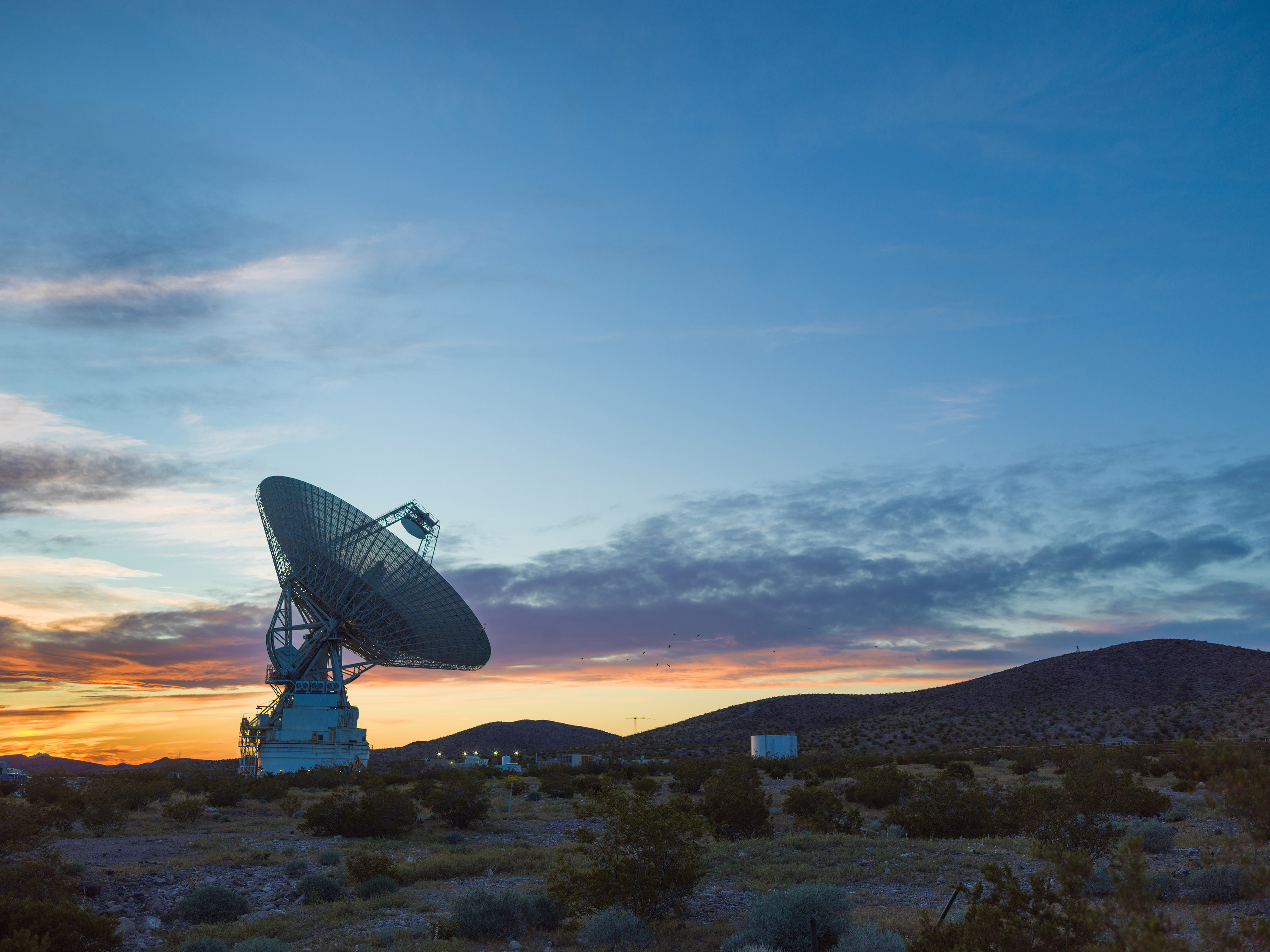
Preparations for Next Moonwalk Simulations Underway (and Underwater) This sunset photo shows Deep Space Station 14, the 230-foot-wide (70-meter) antenna at the Goldstone Deep Space Communications Complex near Barstow, California, part of NASA’s Deep Space Network.NASA/JPLNASA has completed the investigation into the damage sustained last year at its 70-meter radio-frequency antenna, known as the Deep Space Station 14 (DSS-14), at the Goldstone Deep Space Communications Complex near Barstow, California. The agency has classified the event as a Type A mishap based on the total cost of damages. The antenna will remain offline to complete repairs and previously scheduled upgrades.
“NASA takes safety and any departure from established procedures seriously, and the investigation at Goldstone made clear that we must strengthen our processes. We are acting on the investigation’s findings,” said Joel Montalbano, acting associate administrator for NASA’s Space Operations Mission Directorate at the agency’s headquarters in Washington. “We will update and improve procedures, rebuild core in-house capabilities, and reinforce operational discipline across the Deep Space Network. NASA remains focused on learning from this and modernizing systems, so DSS-14 and the broader network are ready to support our ambitious future missions.”
On Sept. 16, 2025, the DSS‑14 antenna over‑rotated while actively tracking the Juno mission, placing excessive stress on cabling and associated structural supports. Water lines tied to the antenna’s fire‑suppression system also were damaged, causing significant flooding in the facility. There were no injuries.
NASA convened a Mishap Investigation Board, bringing together experts from across the agency to examine the technical, organizational, and cultural factors behind the incident. The board conducted on‑site inspections, interviews, and detailed reviews of technical documentation and operational logs from all three Deep Space Network sites. The board completed its final report in April and submitted it for agency concurrence.
The investigation issued findings and recommendations that emphasize training, technical rigor, operational procedures, system design, clear roles and responsibilities, and safety assurance. At the same time, teams already are applying lessons learned across all network sites to improve operational consistency. These steps will help bolster the network and reduce the risk of future mishaps.
In its final report, the board found the mishap primarily stemmed from software weaknesses, human error, and an undetected failure in the antenna’s hydraulic limit system. Investigators determined an electrical issue at the antenna the previous day caused the control system to misreport the antenna’s rotation state, an issue that went unnoticed and triggered multiple limit-stops during the Juno track on Sept. 16. While working to identify the limit-stop problem, operators performed several troubleshooting steps that inadvertently bypassed software and hardware safeguards, which ultimately led to the over-rotation incident. After flooding in the antenna base was observed, operators attempted to stow the antenna as a safety precaution, however, because the system had already passed the rotation limits, this action drove the antenna further into over‑rotation, causing additional damage.
Additionally, the investigation found the antenna’s hydraulic limit system, its final mechanical safeguard, was inoperable on Sept. 16 after being damaged in an undocumented prior incident. The system also had not been adequately tested for an undetermined period of time.
Investigators also concluded workplace culture pressured operators to work as expeditiously as possible, often stretching beyond their usual roles, expertise, and training, to keep the antenna operating. The board states the cultural conditions observed at Goldstone were not present at the network’s other sites, where roles and responsibilities are followed more consistently. Other contributing factors outlined in the report include inadequate procedures, reliance on undocumented practices and tacit knowledge, and gaps in the antenna’s control logic. NASA will accept this as the final report.
The agency estimates repairs will cost between $4.1 and $4.6 million, with a final figure to be determined after the antenna’s systems are fully assessed. The antenna will remain offline as it enters its previously scheduled extended maintenance and upgrade period, originally set to begin in August and expected to be completed by October 2028. These upgrades are part of broader network improvements essential to supporting future exploration and science missions, as well as enhancing the nation’s planetary defense capabilities.
“We are committed to learning everything we can from this incident, and we’ve already begun putting those lessons into practice,” said Kevin Coggins, deputy associate administrator for NASA’s SCaN (Space Communications and Navigation) Program at the agency’s headquarters. “Our teams are working to strengthen and standardize processes and training across all three network sites to ensure it remains resilient, consistent, and ready to support the next generation of missions. Every challenge is an opportunity to improve, and this is no exception.”
The Deep Space Network continues to provide full coverage for more than 40 missions despite the DSS‑14 incident. The network’s 13 other antennas, located at complexes in California, Australia, and Spain, are supporting all tracking needs without interruption. A dedicated scheduling team allocates antenna time across the network to meet each mission’s science and data‑return objectives. The team also maintains continuous coverage when an antenna goes offline for maintenance or an unexpected outage.
To view the report, which includes redactions to protect proprietary and privacy-sensitive material, visit:
Missions
Humans in Space
Climate Change
Solar System
First Steps: America’s Grueling Second Spacewalk
One year after Gemini IV astronaut Edward H. White completed NASA’s first spacewalk the agency prepared for a demanding second excursion. Originally scheduled for Gemini VIII, the extravehicular activity (EVA) was reassigned to Gemini IX-A after that mission ended early, with Gene Cernan taking on the task.
On June 5, 1966—the mission’s third day—Cernan exited the spacecraft and quickly found himself fighting his own equipment. His spacesuit was so rigid that even simple movements required intense effort. He struggled to complete the simplest maneuvers.
Within minutes, Cernan was exhausted and sweating profusely. His spacesuit was cooled only through the circulation of oxygen and as he worked to complete the goals of the EVA, his helmet fogged over completely, obstructing his view and his heart rate rose to about 180 beats per minute. As concerns grew that he might lose consciousness, the EVA was called off and Cernan’s spacewalk ended after two hours and eight minutes.
When Gemini IX-A returned to Earth, doctors found that Cernan had lost 13 pounds during the three-day mission, most of it water lost during his EVA.
The challenges Cernan faced that day reshaped NASA’s approach to spacewalking. His experience directly influenced improved training methods, refined EVA procedures, and precipitated advances in spacesuit design—key steps in preparing astronauts for lunar surface missions just a few years later.
Credit: NASA
Fighting Fire With Fire
- Earth
- Earth Observatory
- Image of the Day
- EO Explorer
- Topics
- More Content
- About
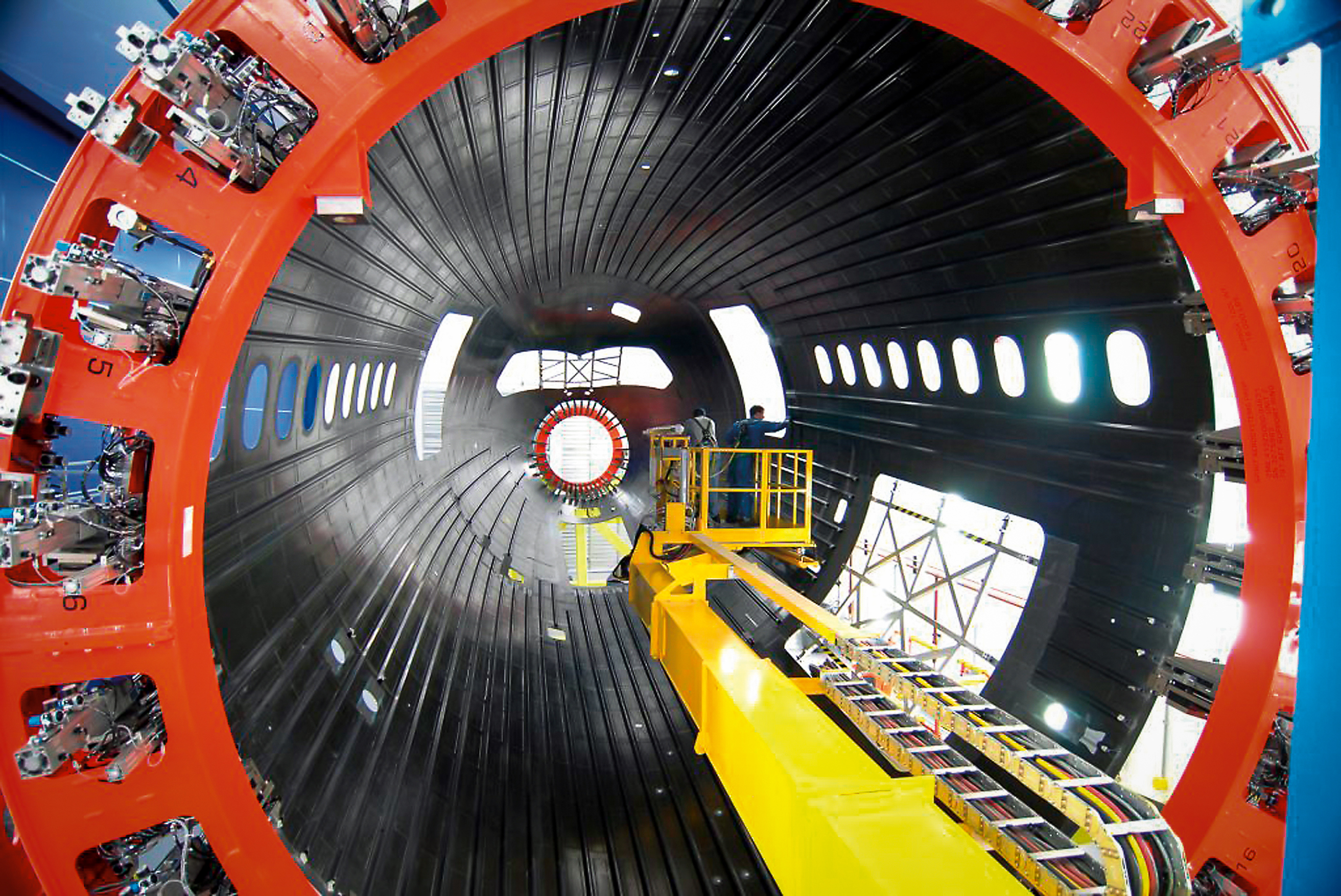
NASA Hosts 2026 Review on Advanced Composite Manufacturing
2 min read
Preparations for Next Moonwalk Simulations Underway (and Underwater) Boeing assembles a composite aircraft fuselage section in one of its production facilities. Composite materials are used in major portions of modern aircraft, including sections of the fuselage and wings on aircraft such as the Boeing 787. NASA’s HiCAM project aims to help accelerate manufacturing processes for future composite aircraft. BoeingNASA’s Hi-Rate Composite Aircraft Manufacturing (HiCAM) project brought together its full team of Advanced Composites Consortium partners for a 2026 spring review at NASA’s Langley Research Center in Hampton, Virginia.
The meeting took place May 5-7, bringing together about 150 people from the consortium, a 22-member public-private partnership.
The review gave NASA and industry partners a chance to look at recent progress and plan for the work ahead. NASA announced recent portfolio decisions, selecting technologies that can have the greatest impact on manufacturing rate for the next airplane program.
During the meeting, teams reviewed the latest results from the project’s Development Phase and discussed early progress under Phase 2, known as the Demonstration Phase. This phase will scale up key manufacturing technologies in the coming years.
A major part of the event included full-day workshops focused on assembly demonstrations of two large aircraft structures: the wing and fuselage. These sessions brought together NASA researchers, industry engineers, and partners to share updates, exchange ideas, and discuss long-term plans. Many teams said they noticed stronger collaboration and coordination across the group this year.
That collaboration supports HiCAM’s goal of large-scale manufacturing demonstrations of a composite fuselage barrel and wing box in 2028 and 2029. These demonstrations represent major project milestones and will help show how advanced composite materials and processes could support faster, lower cost aircraft production.
NASA and its partners continue to make steady progress toward the project’s goals. The project’s work could help pave the way for new manufacturing methods for lightweight composite structures that make future aircraft easier to build and more efficient to operate.
Kimiko Booker
NASA Langley Research Center
NASA-Funded Study Shows Wildfire Smoke’s Hidden Ozone Toll
- Earth
- Explore
- Science at Work
- Multimedia
- Data
- For Researchers
- About Us
NASA’s Goddard Space Flight Center
Wildfire smoke is stoking a new challenge for cleaner air. A NASA-supported study published Thursday found that, over the last decade, wildfires have worsened ground-level ozone pollution across much of the contiguous United States, creating unhealthy air far from active flames.
Wildfires have become an increasingly important contributor to ground-level ozone, or smog, across much of the United States, researchers report June 4 in the journal Science. Nationally, fires offset nearly four years’ worth of ozone-control gains, with larger setbacks in the West and Midwest.
Smoke often is associated with the soot, ash, and other fine particles that make the air look hazy. But wildfires also emit gases such as carbon monoxide, which can help form surface ozone in sunlight when other pollutants are present. Surface ozone is an invisible pollutant harmful to human health, plants, and crops. As smoke plumes travel and mix with other pollution, those reactions can drive ozone increases hundreds or even thousands of miles from active fires.
“NASA Earth observations, along with ground monitoring networks, help reveal air quality risks from wildfires that can cross state lines, giving air quality managers better decision-making information as wildfire smoke affects more communities,” said John Haynes, manager of NASA Earth Action’s Health and Air Quality program at the agency’s Headquarters in Washington. “This is a strong example of NASA science serving communities here in the U.S.”
Building a clearer ozone pictureHigh in the atmosphere, ozone shields Earth from harmful ultraviolet radiation. Near the ground, however, ozone can irritate lungs, worsen asthma and other respiratory diseases, and increase health risks for children, older adults, outdoor workers, and people with existing health conditions.
To track surface ozone changes, researchers turned to deep learning, a form of artificial intelligence that finds patterns across large datasets. They used it to build a first-of-its-kind dataset estimating daily surface ozone from 2003 to 2024 on a kilometer-by-kilometer grid — about 0.6 miles on each side — across the contiguous U.S. The work received support from NASA’s Health and Air Quality program and other NASA grants.
The scientists combined data from about 1,000 ground-based air quality stations with atmospheric model data, weather information, wildfire pollution data, and satellite-derived information, including products from the Visible Infrared Imaging Radiometer Suite (VIIRS) and the Moderate Resolution Imaging Spectroradiometer (MODIS) instruments.
Smoke from Canada’s 2023 wildfires spread across North America. Tan to deep red colors show smoke intensity, estimated from black carbon in NASA’s GEOS-FP model. NASA’s Scientific Visualization Studio (SVS) and NASA’s Global Modeling Assimilation Office (GMAO)Their analysis revealed two distinct periods. From 2003 to 2015, U.S. ground-level ozone generally declined as emissions of ozone-forming pollutants decreased. After 2015, however, those gains slowed or reversed in many places. By comparing estimated ozone levels with scenarios that removed wildfire influence, the researchers found that pollution from wildfires was a main factor in that shift.
Without the wildfire contribution, ground-level ozone in the Midwest, for example, would likely have continued to decline. Instead, wildfires erased about 5.3 years’ worth of ozone-control progress since 2015.
“People in the Midwest may think fires burning far away will not affect them,” said the study’s corresponding author Jun Wang, an atmospheric scientist at the University of Iowa in Iowa City. “But once wildfire pollution is in the air, it can move across regions. Pollution from one place can affect air quality in another.”
Measuring the health tollThe study also found that wildfire-driven ozone increased exposure to unhealthy air and likely contributed to premature deaths. Premature deaths associated with long-term wildfire-related ozone exposure in the U.S. increased by an estimated 318 deaths per year after 2013, with the post-2013 average 46% higher than in the previous decade. The researchers calculated premature deaths using average lifespan, ozone exposure estimates, and population density.
The 2023 Canadian wildfires showed how widely those risks can spread, with smoke-driven ozone increases stretching across the Midwest and into parts of the Northeast and South. Overall, from 2022 to 2024, wildfires exposed an additional 43 million people in the U.S. to conditions that did not meet current federal air quality standards for ozone, the researchers estimated.
Capturing that national picture is difficult from ground monitors alone. Ground monitors remain the backbone of U.S. air quality tracking, but they do not cover every community. NASA’s scientifically validated satellite observations and models help researchers and agencies see air quality patterns across states, regions, and fire seasons.
That broader air quality work includes newer missions such as TEMPO (Tropospheric Emissions: Monitoring of Pollution). Launched in 2023, TEMPO is NASA’s first mission to use a space-based spectrometer to provide hourly daytime measurements of air quality over North America. Its view is sharp enough to distinguish pollution patterns, including surface ozone, across areas only a few square miles wide, a major improvement over earlier satellites.
Together, these capabilities help researchers and agencies see smoke-related ozone patterns that might otherwise be harder to detect, especially in rural and remote areas.
The work also points toward a practical use of NASA science during fire season. Wang’s team has used NASA support to develop FireAQ, a decision-support system that brings satellite observations, model forecasts, and fire and aerosol products into weekly briefings with state and local air quality officials. The goal is to help officials see where smoke-related pollution may move next and give communities better information.
Discover more about NASA’s air quality observations
About the Author Emily DeMarco Writer/Editor (IV), Earth Science Division
Share
Details Last Updated Jun 05, 2026 Contact Emily DeMarco emily.p.demarco@nasa.gov Location Goddard Space Flight Center Related Terms Explore More 3 min read Fighting Fire With FireIn fire-prone ecosystems in Australia’s Northern Territory, prescribed burns are lit to minimize the severity…
Article
16 hours ago
4 min read A Moonlit Earth as Seen From Artemis II
An astronaut’s photo, taken en route to the Moon, reveals our planet and its place…
Article
2 days ago
2 min read Typhoon Jangmi
The sprawling storm promised to deliver torrential rain across a wide swath of southern Japan.
Article
3 days ago
Keep Exploring Discover More Topics From NASA Air Quality
Air pollution is a significant threat to human health and our environment. Instruments on NASA satellites, along with airborne and…
Wildfires
Landsat satellites monitor wildfire extent, burn severity, and post-fire recovery since the 1970s, helping managers assess damage, improve safety, estimate…
Earth Science at Work
NASA Earth Science helps Americans respond to challenges and societal needs — such as wildland fires, hurricanes, and water supplies…
NASA Knows: The Ozone Hole
This is the story of the hole in Earth’s protective ozone layer: what it is, how it formed, and the…
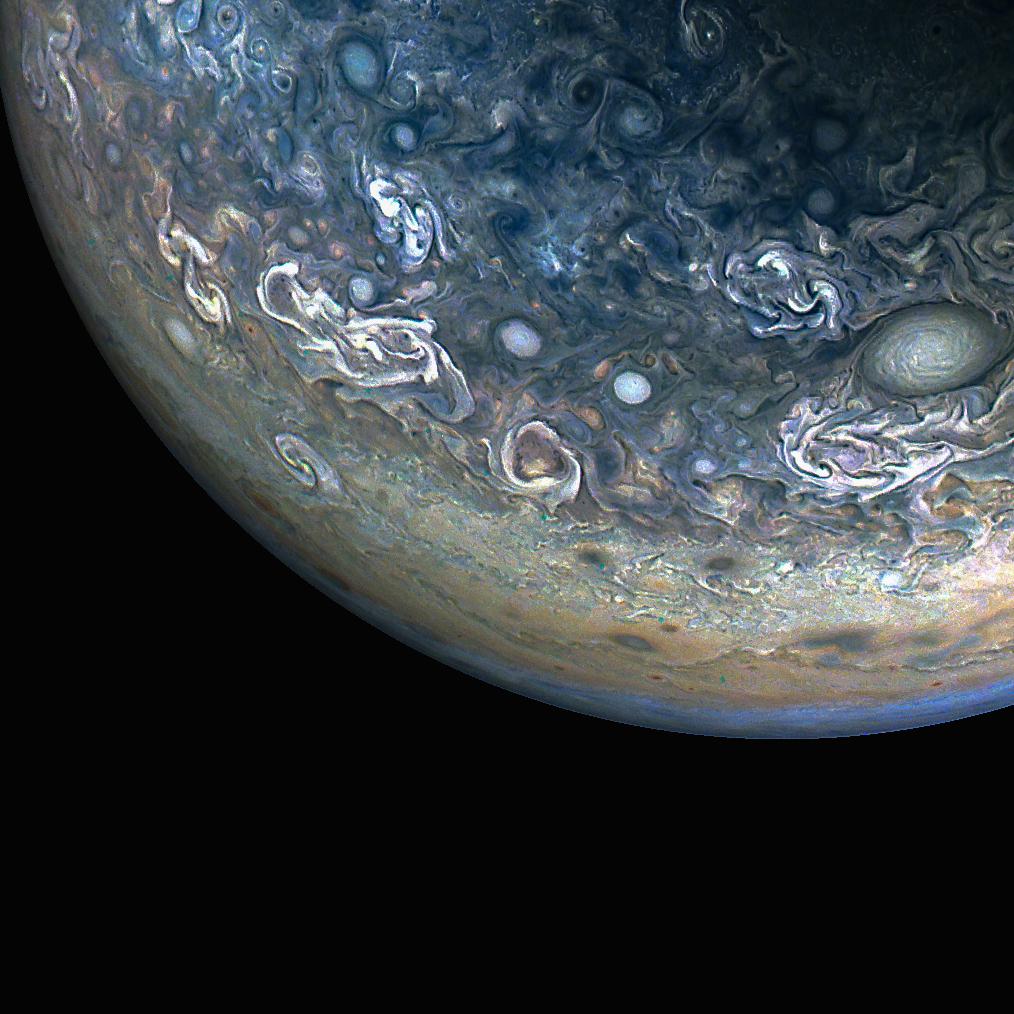
Colorful, Chaotic Jupiter
NASA’s Juno spacecraft captured this color-enhanced view of Jupiter’s northern hemisphere during its 61st close flyby of the giant planet on May 12, 2024.
Citizen scientist Gary Eason made this image using raw data from the JunoCam instrument, applying digital processing techniques to enhance color and clarity. It provides a detailed view of chaotic clouds and cyclonic storms in an area known to scientists as a folded filamentary region. In these regions, the zonal jets that create the familiar banded patterns in Jupiter’s clouds break down, leading to turbulent patterns and cloud structures that rapidly evolve over the course of only a few days.
Learn more about opportunities to do NASA science with citizen science projects.
Image credit: NASA/JPL-Caltech/SwRI/MSSS; Image processing by Gary Eason © CC BY
A Moonlit Earth as Seen From Artemis II
- Earth
- Earth Observatory
- Image of the Day
- EO Explorer
- Topics
- More Content
- About
Curiosity Blog, Sols 4908-4912: Goodbye Campo Marte, It’s Been Fun!
- Curiosity Home
- Science
- News and Features
- Multimedia
- Mars Missions
- Mars Home
5 min read
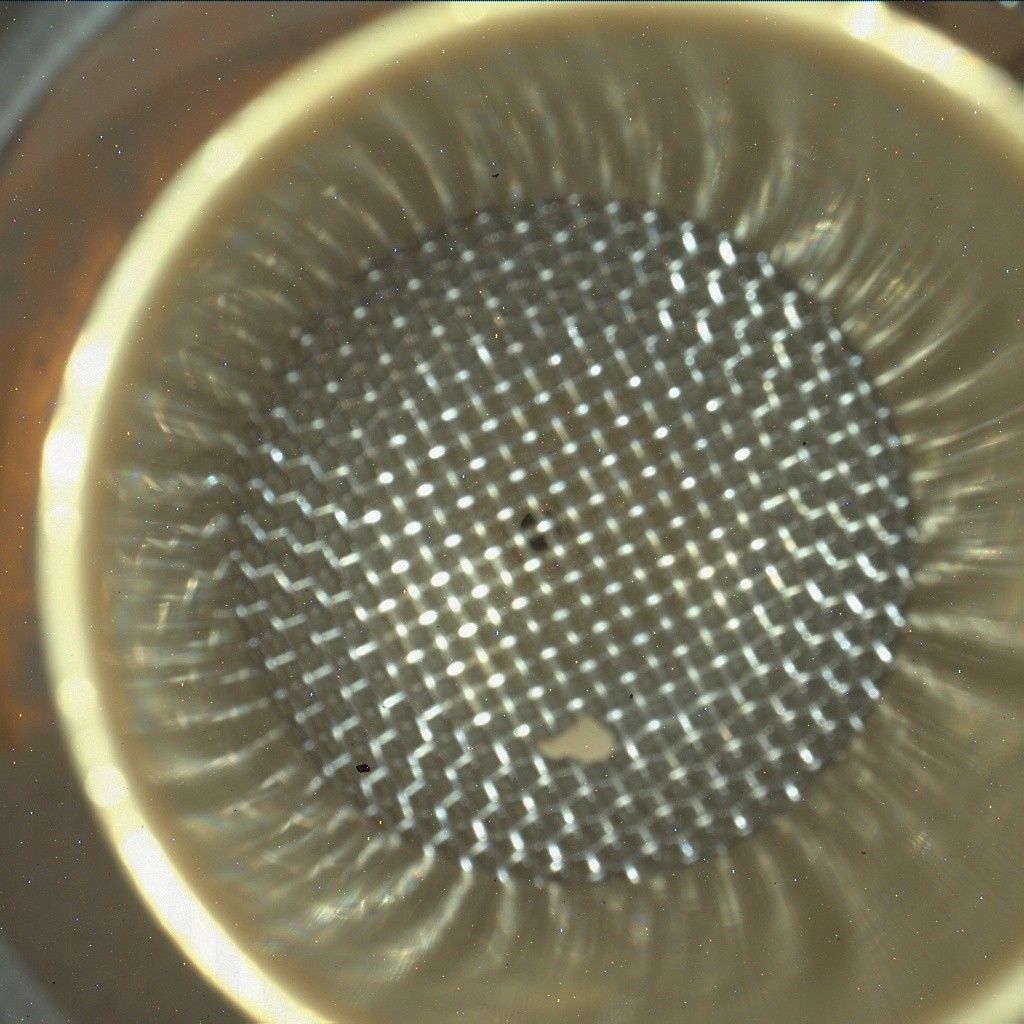
Curiosity Blog, Sols 4908-4912: Goodbye Campo Marte, It’s Been Fun! NASA’s Mars rover Curiosity acquired this image of the inlet on its Chemistry & Mineralogy X-Ray Diffraction instrument (CheMin), which is about the size of a laptop computer and sits inside rover’s body, where it analyzes the chemical composition of rocks and soil. Curiosity captured the image using its Mars Hand Lens Imager (MAHLI), a close-up camera located on the turret at the end of the rover’s robotic arm, on May 28, 2026 — Sol 4908, or Martian day 4,908 of the Mars Science Laboratory Mission — at 11:14:14 UTC. NASA/JPL-Caltech/MSSSBy Susanne P. Schwenzer, Professor of Planetary Mineralogy at The Open University, UK
Earth planning date: Friday, May 29, 2026
Drilling always keeps the rover in place for a little while, and our 47th successful drill, “Campo Marte,” was no exception. The team used the time wisely and on top of the drilling, we also have many observations. Thinking for a long time about a workspace always gets me attached to the area — some more than others; at the shorter stops, especially — when I am on shift several times during this time. I was Science Operations Working Group chair three times while we were here, so it’s a real “Goodbye” for me today as we are driving onward to reach the next area up the hill on Mount Sharp.
The Campo Marte drill was successful, as my colleague Abigail Fraeman reported last week. This week was spent investigating the aftermath of the drilling, which means running the CheMin instrument to get mineralogical data and the SAM instrument to inspect the volatile releases. ChemCam, APXS, MAHLI and Mastcam were also busy documenting the drill hole and the drill fines, as well as how much sample there was available overall.
Of course, Curiosity also had a very good look at the other interesting targets in the area! Besides all the work on the drill hole, ChemCam carried out an expert’s targeting exercise by setting two targets up to aim at two different layers on adjacent spots on the finely laminated sediments. That involves aiming at millimeter-sized targets, named “Corcovado” and “Junakas,” respectively, about 3 meters away (about 10 feet)! We are curious if the layers are chemically different, which would tell us about different formation conditions, or if they are similar and the conditions when those layers formed were more similar. ChemCam is also looking at the target “Palcaya” to get more data on the chemistry of the layered bedrock, and will investigate the target “Alcamachi,” which is a float rock that looks intriguingly dark. Maybe that tells us it’s got a different chemistry? We will find out when we get the data!
In addition to the chemistry measurements, ChemCam will also carry out a spectral investigation on the target “Magallanas,” which was a little too far away to also point the laser at it, but is intriguingly dark. This last week, ChemCam also planned three long-distance RMIs to document the sedimentary structures — younger and older ones — in the surrounding area. One of them drew the suspicion that it might break a record: it might be the longest strip of RMI images we have taken in one mosaic! The jury is out, it’s 24 frames and this way links up with an earlier, shorter set of images. The reason the mosaic is so long is because it images a small ridge with sedimentary textures that could tell us about the depositional conditions when the rock layers formed. But how cool is that — at 13+ years to still break our own records?
Since our arrival, Mastcam has been very busy getting the entire region around us imaged. In addition, some higher-resolution mosaics have been taken, most notably one of the locations where the remaining sample was dropped, and then of the workspace to see again how much sample might — or might not — have been left in the drill stem and fallen out when Curiosity did the motions that are designed to shake any remaining sample out of the drill, to leave it prepared for the next time. Another imaging task, but for MAHLI, is to always image the sample inlets, also, to see if they are clean and prepared for the next sample. I included the MAHLI image of the CheMin inlet — don’t worry about the little rock, it’s with us for a while, and the CheMin team now calls it “our pet rock.”
APXS joined the drill-hole investigations and has been focused on it even more than usual. The team decided that this is a very good opportunity to increase counting statistics beyond the usual and well-tested levels by significantly increasing the measurement time. To achieve that, it measured the Campo Marte drill fines in all plans of this week. And on the last night of that, MAHLI gets out its LED lights to finish the experiment with a sparkling nighttime MAHLI experiment to document it all.
Our environmental team has kept the rover busy by looking at atmospheric opacity, dust activity, dust-devil activity and, of course, also monitoring the environment in general. With all this finished, the rover will continue its way up the hill to the next interesting area. I heard something like “cross-bedding” during the discussions, but as a mineralogist, I just note that that decision was taken by people who know more about sediments than I do, while I am itching to see the CheMin mineralogy results!
-
Want to read more posts from the Curiosity team?
-
Want to learn more about Curiosity’s science instruments?
Article
6 days ago
3 min read Curiosity Blog, Sols 4893-4899: Drilling at Campo Marte and a Visit From the Psyche Spacecraft
Article
2 weeks ago
3 min read Curiosity Blog, Sols 4886-4892: Ingenuity and Perseverance, Curiosity Style
Article
3 weeks ago
Keep Exploring Discover More Topics From NASA Mars
Mars is the fourth planet from the Sun, and the seventh largest. It’s the only planet we know of inhabited…
All Mars Resources
Explore this collection of Mars images, videos, resources, PDFs, and toolkits. Discover valuable content designed to inform, educate, and inspire,…
Rover Basics
Each robotic explorer sent to the Red Planet has its own unique capabilities driven by science. Many attributes of a…
Mars Exploration: Science Goals
The key to understanding the past, present or future potential for life on Mars can be found in NASA’s four…
NASA Finds New Way Earth May Have Received Elements Needed for Life
Illustration: ESO
NASA-supported scientists have provided new information about how the early Earth may have acquired some elements necessary for the planet to become habitable. They also suggest a new role for Jupiter in the distribution of these elements throughout the young solar system. The study, published today in Science Advances, examines this history by looking at the ratio of phosphorus to nitrogen in iron meteorites and in younger objects known as chondrites.
The study suggests that Earth acquired its inventory of the life-essential elements phosphorous and nitrogen primarily from the inner solar system, without requiring a significant contribution from outer solar system chondritesDebjeet Pathak
Rice University
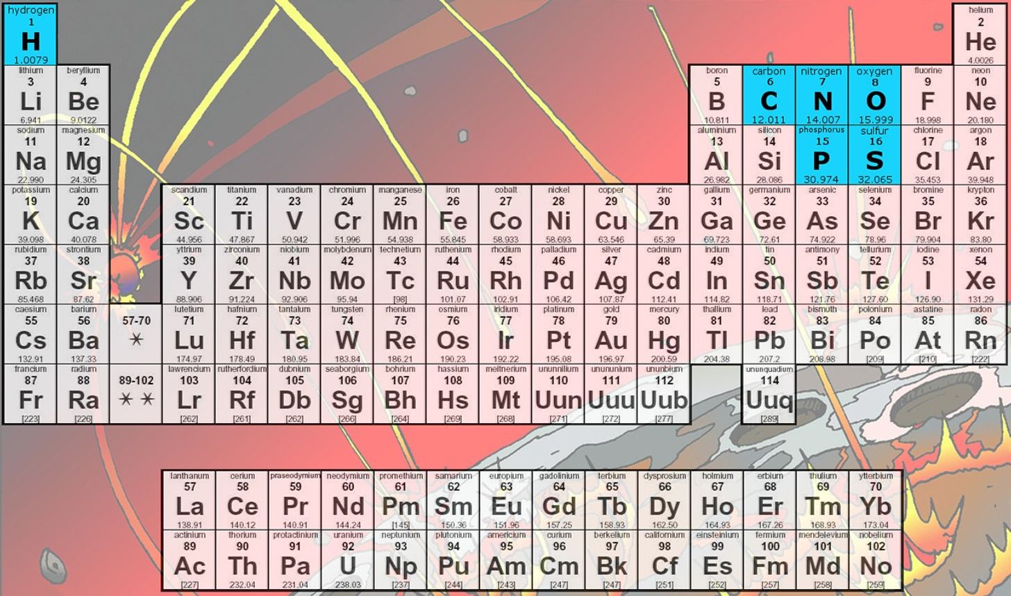
Planetary system formationOur solar system formed from gas and dust that swirled around the proto-Sun more than 4.5 billion years ago. This gas contained the raw materials needed to form planets, moons, and ultimately life as we know it. Two elements of particular importance for life are nitrogen and phosphorus.
All life on Earth needs the same elements: carbon, hydrogen, nitrogen, oxygen, phosphorus, and sulfur (CHNOPS). These elements came from space, born inside stars and spread in clouds of gas and dust. Gravity then caused this material to gather together, forming new stars and smaller objects like planets. NASAIn the earliest stages of the solar system, gas and dust coalesced into bodies known as planetesimals. As these objects orbited the young Sun in this chaotic environment, planetesimals collided, leaving shattered remnants throughout the system. Eventually, many of these pieces were incorporated into planets and moons. Other pieces survive today as asteroids, still orbiting the Sun, and – if they have impacted the Earth and been recovered – as meteorites. These meteorites provide a window into the early solar system at a time before the Earth existed. Chondrites and iron meteorites are two different classes of these meteorites.
As their name suggests, iron meteorites are dense, metallic objects and are primarily made of iron-nickel alloy. Chondrites, on the other hand, are stony objects and they are responsible for most of the meteorites that have been found on Earth.
Each type of meteorite originates from planetesimals that formed at different times in our system. The oldest generation of planetesimals are the source of iron meteorites. Chondrites came from a second generation of planetesimals that formed 2-3 million years later.
Habitable planet buildingUnderstanding how the Earth was made and the timing of its formation is important for astrobiologists who study how and when our planet became habitable for life as we know it. The young Earth needed to have a supply of life’s ingredients, including nitrogen and phosphorus, for the first living cells to form.
There is debate between scientists over where Earth’s stock of life-essential elements came from. Some evidence points to chondrites in the outer solar system traveling inward to arrive at Earth late in our planet’s formation process. However, the new study tells a different story.
Using laboratory experiments and geochemical models, the team reconstructed a map of phosphorus-nitrogen (P/N) ratios across the early solar system and found differences between the first (iron meteorites) and second (chondrites) generations of planetesimals.
An illustration of our solar system. The asteroid belt is located between Mars and Jupiter, separating our system into what we refer to as the inner and outer regions. NASA/JPL-CaltechThe experiments and subsequent geochemical modeling showed that the first generation had a higher ratio of P/N in the outer solar system, with that ratio decreasing toward the inner solar system. This trend was reversed in the second generation of planetesimals, with higher P/N ratios in the inner solar system.
The thought is that during the formation of the first generation of planetesimals, there was an outward flow of material that raised the P/N ratio in the outer solar system. Then came Jupiter.
For our own solar system, Jupiter’s presence and growth history, indeed, seem to have played a critical role in determining the distribution of the basic chemical ingredients necessary for habitable worlds.Rajdeep Dasgupta
Rice University
As Jupiter formed and grew to a tremendous size (and gravitational influence), the planet restricted the movement of phosphorus and nitrogen from the inner to outer solar system. This meant that when the second generation of planetesimals appeared, those in the inner solar system were left with a higher P/N ratio than their cousins further out.
“For our own solar system, Jupiter’s presence and growth history, indeed, seem to have played a critical role in determining the distribution of the basic chemical ingredients necessary for habitable worlds,” said Rajdeep Dasgupta of Rice University in Houston and senior author on the study. “It remains an open question whether a life-essential element budget similar to Earth’s can be established without a Jupiter-like planet in the population.”
Geochemical accretion modeling further shows that Earth’s present-day P/N signature is best reproduced by the inner solar system planetesimals, either those related to iron meteorites or those related to chondrites.
“The study suggests that Earth acquired its inventory of the life-essential elements phosphorous and nitrogen primarily from the inner solar system, without requiring a significant contribution from outer solar system chondrites,” said study lead author Debjeet Pathak, graduate student at Rice University.
For more information on astrobiology at NASA, visit:
https://science.nasa.gov/astrobiology
Karen Fox / Molly Wasser
Headquarters, Washington
202-358-1600
karen.c.fox@nasa.gov / molly.l.wasser@nasa.gov
Share
Details Last Updated Jun 03, 2026 Related Terms Explore More 5 min read NASA Uses Mineralogical Marker to Understand Ancient Martian ClimateScientists analyzed 20 Martian samples collected by NASA’s Curiosity Rover and found that differences in…
Article
6 days ago
5 min read NASA Research Shows Early Life Relied on Rare Metal
Article
4 weeks ago
8 min read Optical Vortex Phase Masks for the Detection of Habitable Worlds
A team of NASA researchers is developing new types of optical masks that could help…
Article
2 months ago
Keep Exploring Discover More Astrobiology Topics From NASA
Astrobiology Program Overview
Astrobiology Multimedia
Astrobiology Publications
Funded Astrobiology Research at NASA
International Sea Level Satellite Observes El Niño Precursor
NASA/JPL-Caltech Photojournal Navigation Downloads International Sea Level Satellite Observes El Niño Precursor
MP4 (1.10 MB)
Description
Sea level height data from the international Sentinel-6 Michael Freilich satellite collected from March to May 2026 show higher, warmer water moving from the western Pacific Ocean to just off the coast of Colombia, Ecuador, and Peru. This phenomenon is known as a warm Kelvin wave, signified in this animation of the data by yellow, orange, red, and white. The emergence of Kelvin waves in the early part the year is a signal that an El Niño event is likely to follow.
In early 2026, measurements from Sentinel-6 Michael Freilich showed a small Kelvin wave forming around Micronesia in late January and dissipating by mid-February. The wave shown in the animation emerged in early March, then moved east over time. By mid-May, the seas around Peru were more than 5.9 inches (15 centimeters) higher than long-term averages. Because water expands as it warms, a rise in elevation of an area of the ocean indicates increasing temperature.
The additional heat at the sea surface can change the circulation patterns of energy, water, and air in the atmosphere, which can affect weather. El Niños can cause heavy precipitation in some regions and deficits in others, influencing daily life and commerce around the world.
Sentinel-6 Michael Freilich, named after former NASA Earth Science Division Director Michael Freilich, is one of two satellites that compose the Copernicus Sentinel-6/Jason-CS (Continuity of Service) mission.
Sentinel-6/Jason-CS was jointly developed by ESA, the European Organisation for the Exploitation of Meteorological Satellites (EUMETSAT), NASA, and NOAA, with funding support from the European Commission and technical support on performance from the French space agency CNES (Centre National d’Études Spatiales). Spacecraft monitoring and control, as well as the processing of all the altimeter science data, is carried out by EUMETSAT on behalf of the European Union’s Copernicus programme, with the support of all partner agencies.
A division of Caltech in Pasadena, NASA’s Jet Propulsion Laboratory contributed three science instruments for each Sentinel-6 satellite: the Advanced Microwave Radiometer, the Global Navigation Satellite System – Radio Occultation, and the Laser Retroreflector Array. NASA also contributed launch services, ground systems supporting operation of the NASA science instruments, the science data processors for two of these instruments, and support for the U.S. members of the international Ocean Surface Topography Science Team.
To learn more about Sentinel-6 Michael Freilich, visit:
https://www.nasa.gov/sentinel-6
Keep Exploring Discover More Topics From Photojournal
Photojournal
Search Photojournal
Photojournal’s Latest Content
Feedback
