
NASA News
NASA Tech to Use Moonlight to Enhance Measurements from Space
NASA will soon launch a one-of-a-kind instrument, called Arcstone, to improve the quality of data from Earth-viewing sensors in orbit. In this technology demonstration, the mission will measure sunlight reflected from the Moon— a technique called lunar calibration. Such measurements of lunar spectral reflectance can ultimately be used to set a high-accuracy, universal standard for use across the international scientific community and commercial space industry.
To ensure satellite and airborne sensors are working properly, researchers calibrate them by comparing the sensor measurements against a known standard measurement. Arcstone will be the first mission exclusively dedicated to measuring lunar reflectance from space as a way to calibrate and improve science data collected by Earth-viewing, in-orbit instruments.
To view this video please enable JavaScript, and consider upgrading to a web browser that supports HTML5 video
This visualization demonstrates how Arcstone will operate while in orbit measuring lunar reflectance to establish a new calibration standard for future Earth-observing remote sensors. Arcstone’s satellite platform was manufactured by Blue Canyon Technologies. NASA/Tim Marvel/Blue Canyon Technologies“One of the most challenging tasks in remote sensing from space is achieving required instrument calibration accuracy on-orbit,” said Constantine Lukashin, principal investigator for the Arcstone mission and physical scientist at NASA’s Langley Research Center in Hampton, Virginia. “The Moon is an excellent and available calibration source beyond Earth’s atmosphere. The light reflected off the Moon is extremely stable and measurable at a very high level of detail. Arcstone’s goal is to improve the accuracy of lunar calibration to increase the quality of spaceborne remote sensing data products for generations to come.”
Across its planned six-month mission, Arcstone will use a spectrometer — a scientific instrument that measures and analyzes light by separating it into its constituent wavelengths, or spectrum — to measure lunar spectral reflectance. Expected to launch in late June as a rideshare on a small CubeSat, Arcstone will begin collecting data, a milestone called first light, approximately three weeks after reaching orbit.
“The mission demonstrates a new, more cost-efficient instrument design, hardware performance, operations, and data processing to achieve high-accuracy reference measurements of lunar spectral reflectance,” said Lukashin.
To view this video please enable JavaScript, and consider upgrading to a web browser that supports HTML5 video
Measuring the lunar reflectance at the necessary ranges of lunar phase angles and librations is required to build a highly accurate lunar reference. A satellite platform in space would provide this required sampling. Arcstone will use a spectrometer to demonstrate the ability to observe and establish a data record of lunar spectral reflectance throughout its librations and phases for other instruments to use the Moon to calibrate sensors.NASA/Scientific Visualization StudioMeasurements of lunar reflectance taken from Earth’s surface can be affected by interference from the atmosphere, which can complicate calibration efforts. Researchers already use the Sun and Moon to calibrate spaceborne instruments, but not at a level of precision and agreement that could come from having a universal standard.
Lukashin and colleagues want to increase calibration accuracy by getting above the atmosphere to measure reflected solar wavelengths in a way that provides a stable and universal calibration source. Another recent NASA mission, called the Airborne Lunar Spectral Irradiance mission also used sensors mounted on high-altitude aircraft to improve lunar irradiance measurements from planes.
There is not an internationally accepted standard (SI-traceable) calibration for lunar reflectance from space across the scientific community or the commercial space industry.
“Dedicated radiometric characterization measurements of the Moon have never been acquired from a space-based platform,” said Thomas Stone, co-investigator for Arcstone and scientist at the U.S. Geological Survey (USGS). “A high-accuracy, SI-traceable lunar calibration system enables several important capabilities for space-based Earth observing missions such as calibrating datasets against a common reference – the Moon, calibrating sensors on-orbit, and the ability to bridge gaps in past datasets.”
The Arcstone spacecraft with solar panels installed as it is tested before being integrated for launch. Blue Canyon TechnologiesIf the initial Arcstone technology demonstration is successful, a longer Arcstone mission could allow scientists to make the Moon the preferred reference standard for many other satellites. The new calibration standard could also be applied retroactively to previous Earth data records to improve their accuracy or fill in data gaps for data fields. It could also improve high-precision sensor performance on-orbit, which is critical for calibrating instruments that may be sensitive to degradation or hardware breakdown over time in space.
“Earth observations from space play a critical role in monitoring the environmental health of our planet,” said Stone. “Lunar calibration is a robust and cost-effective way to achieve high accuracy and inter-consistency of Earth observation datasets, enabling more accurate assessments of Earth’s current state and more reliable predictions of future trends.”
The Arcstone technology demonstration project is funded by NASA’s Earth Science Technology Office’s In-space Validation of Earth Science Technologies. Arcstone is led by NASA’s Langley Research Center in partnership with Colorado University Boulder’s Laboratory for Atmospheric and Space Physics, USGS, NASA Goddard Space Flight Center in Greenbelt, Maryland, Resonon Inc., Blue Canyon Technologies, and Quartus Engineering.
For more information on NASA’s Arcstone mission visit:
https://science.larc.nasa.gov/arcstone/about/
About the AuthorCharles G. HatfieldScience Public Affairs Officer, NASA Langley Research Center Share Details Last Updated Jun 20, 2025 LocationNASA Langley Research Center Related Terms Explore More 3 min read NASA Measures Moonlight to Improve Earth Observations Article 2 months ago Keep Exploring Discover More Topics From NASAMissions
Humans in Space
Climate Change
Solar System
NASA’s LRO Views ispace HAKUTO-R Mission 2 Moon Lander Impact Site
On June 11, NASA’s LRO (Lunar Reconnaissance Orbiter) captured photos of the site where the ispace Mission 2 SMBC x HAKUTO-R Venture Moon (RESILIENCE) lunar lander experienced a hard landing on June 5, 2025, UTC.
RESILIENCE lunar lander impact site, as seen by NASA’s Lunar Reconnaissance Orbiter Camera (LROC) on June 11, 2025. The lander created a dark smudge surrounded by a subtle bright halo.Credit: NASA/Goddard/Arizona State University.RESILIENCE was launched on Jan. 15 on a privately funded spacecraft.
LRO’s right Narrow Angle Camera (one in a suite of cameras known as LROC) captured the images featured here from about 50 miles above the surface of Mare Frigoris, a volcanic region interspersed with large-scale faults known as wrinkle ridges.
The dark smudge visible above the arrow in the photo formed as the vehicle impacted the surface, kicking up regolith — the rock and dust that make up Moon “soil.” The faint bright halo encircling the site resulted from low-angle regolith particles scouring the delicate surface.
This animation shows the RESILIENCE site before and after the impact. In the image, north is up. Looking from west to east, or left to right, the area pictured covers 2 miles.Credit: NASA/Goddard/Arizona State University.LRO is managed by NASA’s Goddard Space Flight Center in Greenbelt, Maryland, for the Science Mission Directorate at NASA Headquarters in Washington. Launched on June 18, 2009, LRO has collected a treasure trove of data with its seven powerful instruments, making an invaluable contribution to our knowledge about the Moon. NASA is returning to the Moon with commercial and international partners to expand human presence in space and bring back new knowledge and opportunities.
More on this story from Arizona State University’s LRO Camera website
Media Contact
Karen Fox / Molly Wasser
Headquarters, Washington
202-358-1600
karen.c.fox@nasa.gov / molly.l.wasser@nasa.gov
Lonnie Shekhtman
NASA’s Goddard Space Flight Center, Greenbelt, Md.
lonnie.shekhtman@nasa.gov
NASA Air Taxi Passenger Comfort Studies Move Forward
3 min read
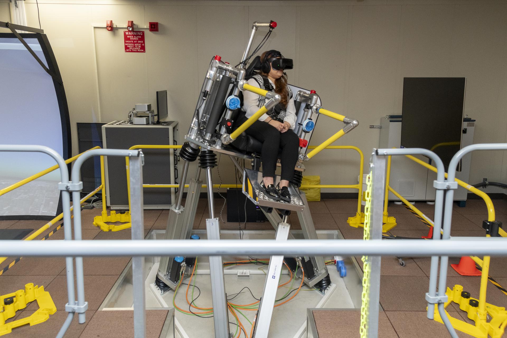
Preparations for Next Moonwalk Simulations Underway (and Underwater) NASA employee Naomi Torres sits inside the air taxi passenger ride quality simulator at NASA’s Armstrong Flight Research Center in Edwards, California, as the simulator moves during a study on Oct. 23, 2024. Research continues to better understand how humans may interact with these new types of aircraft.NASA/Steve FreemanNASA’s Advanced Air Mobility vision involves the skies above the U.S. filled with new types of aircraft, including air taxis. But making that vision a reality involves ensuring that people will actually want to ride these aircraft – which is why NASA has been working to evaluate comfort, to see what passengers will and won’t tolerate.
NASA is conducting a series of studies to understand how air taxi motion, vibration, and other factors affect ride comfort. The agency will provide the data it gathers to industry and others to guide the design and operational practices for future air taxis.
“The results of this study can guide air taxi companies to design aircraft that take off, land, and respond to winds and gusts in a way that is comfortable for the passengers,” said Curt Hanson, senior flight controls researcher for this project based at NASA’s Armstrong Flight Research Center in Edwards, California. “Passengers who enjoy their experience in an air taxi are more likely to become repeat riders, which will help the industry grow.”
The air taxi comfort research team uses NASA Armstrong’s Ride Quality Laboratory as well as the Human Vibration Lab and Vertical Motion Simulator at NASA’s Ames Research Center in California’s Silicon Valley to study passenger response to ride quality, as well as how easily and precisely a pilot can control and maneuver aircraft.
After pilots checked out the simulator setup, the research team conducted a study in October where NASA employees volunteered to participate as passengers to experience the virtual air taxi flights and then describe their comfort level to the researchers.
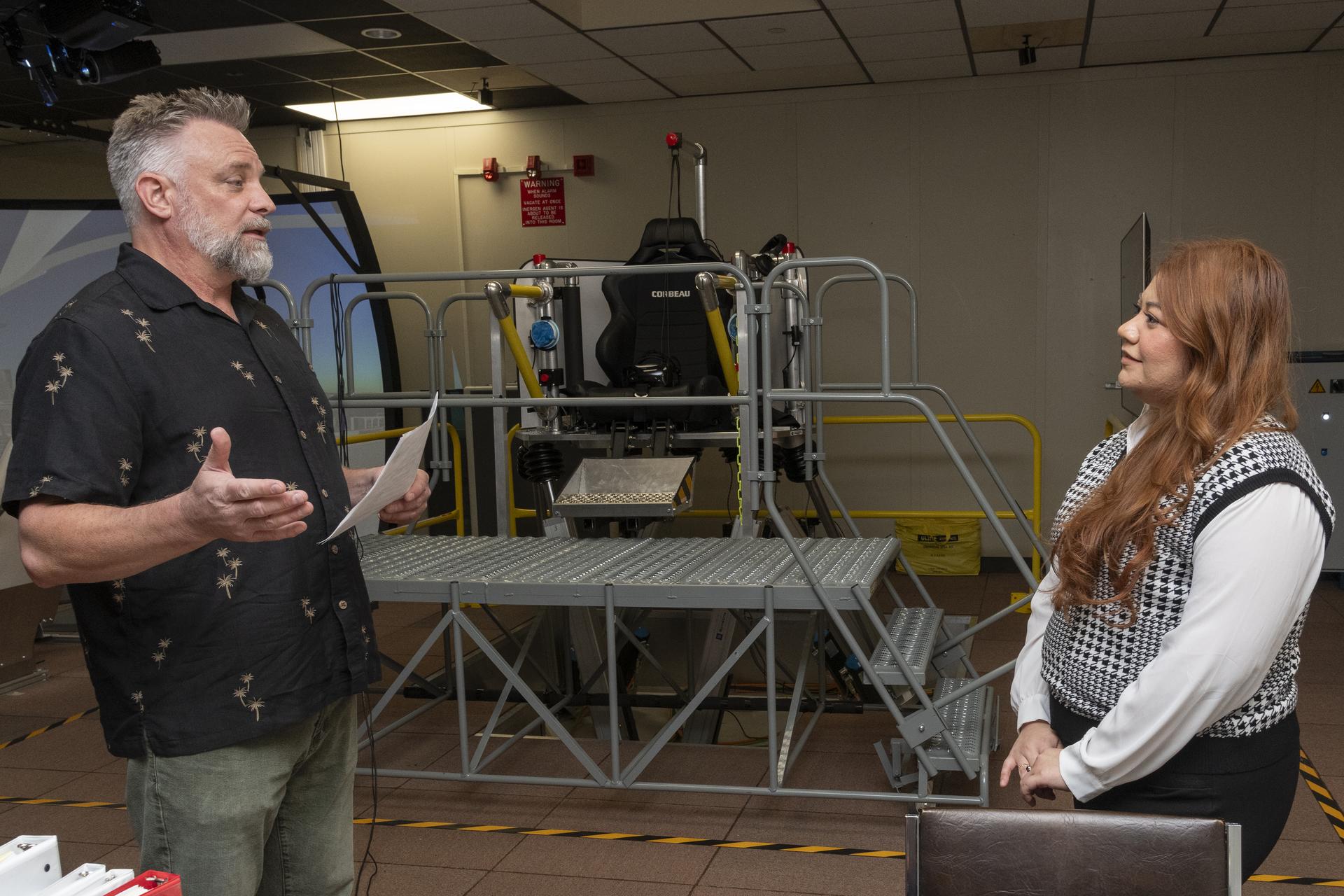
Curt Hanson, senior flight controls researcher for the Revolutionary Vertical Lift Technology project based at NASA’s Armstrong Flight Research Center in Edwards, California, explains the study about to begin to NASA employee and test subject Naomi Torres on Oct. 23, 2024. Behind them is the air taxi passenger ride quality simulator in NASA Armstrong’s Ride Quality Laboratory. Studies continue to better understand passenger comfort for future air taxi rides.NASA/Steve FreemanUsing this testing, the team produced an initial study that found a relationship between levels of sudden vertical motion and passenger discomfort. More data collection is needed to understand the combined effect of motion, vibration, and other factors on passenger comfort.
“In the Vertical Motion Simulator, we can investigate how technology and aircraft design choices affect the handling qualities of the aircraft, generate data as pilots maneuver the air taxi models under realistic conditions, and then use this to further investigate passenger comfort in the Ride Quality and Human Vibration Labs,” said Carlos Malpica, senior rotorcraft flight dynamics researcher for this effort based at NASA Ames.
This work is managed by the Revolutionary Vertical Lift Technology project under NASA’s Advanced Air Vehicles Program in support of NASA’s Advanced Air Mobility mission, which seeks to deliver data to guide the industry’s development of electric air taxis and drones.
Share Details Last Updated Jun 20, 2025 EditorDede DiniusContactTeresa Whitingteresa.whiting@nasa.govLocationArmstrong Flight Research Center Related Terms Explore More 2 min read NASA Aircraft to Make Low-Altitude Flights in Mid-Atlantic, California Article 3 days ago 4 min read NASA to Gather In-Flight Imagery of Commercial Test Capsule Re-Entry Article 5 days ago 4 min read NASA Tech to Measure Heat, Strain in Hypersonic Flight Article 5 days ago Keep Exploring Discover More Topics From NASAArmstrong Flight Research Center
Humans in Space
Climate Change
Solar System
Summer Begins in Northern Hemisphere
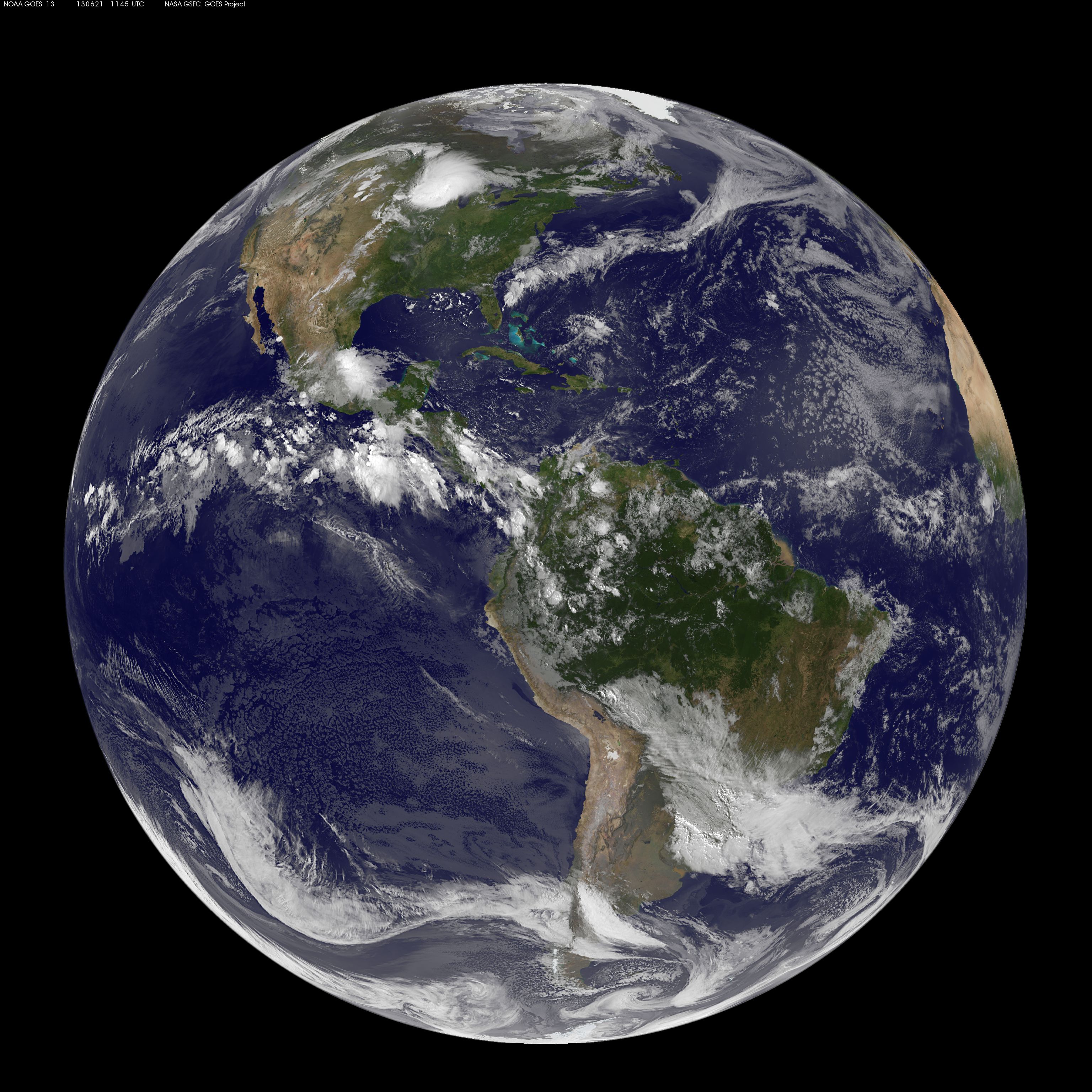
This full-disk image from NOAA’s GOES-13 satellite was captured at 7:45 a.m. EDT (11:45 UTC) and shows the Americas on June 21, 2012, the start of astronomical summer – in the Northern Hemisphere – that year.
The first day of summer in 2025 is June 20; it is also the longest day of the year. In the Southern Hemisphere, it’s the shortest day of the year and the beginning of winter.
Earth orbits at an angle, so the Northern Hemisphere is tilted toward the Sun half of the year — this is summer in the Northern Hemisphere, and winter in the Southern Hemisphere. The other half of the year, the Northern Hemisphere is tilted away from the Sun, creating winter in the north and summer in the south. Solstices happen twice per year, at the points in Earth’s orbit where this tilt is most pronounced.
Image credit: NASA
NASA History News and Notes – Summer 2025
7 min read
Preparations for Next Moonwalk Simulations Underway (and Underwater)In the summer 2025 issue of the NASA History Office’s News & Notes newsletter, examples of leadership and critical decision-making in NASA’s history form the unifying theme. Among the topics discussed are NASA’s Shuttle-Centaur program, assessing donations to the NASA Archives, how the discovery of the first exoplanet orbiting a sun-like star catalyzed NASA’s exoplanet program, and Chief of the Medical Operations Office Charles A. Berry’s decisions surrounding crew health when planning the Project Gemini missions.
Volume 42, Number 2
Summer 2025
By Brian Odom
NASA’s is a history marked by critical decisions. From George Mueller’s 1963 decision for “all up” testing of the Saturn V rocket to Michael Griffin’s 2006 decision to launch a final servicing mission to the Hubble Space Telescope, the agency has continually met key inflection points with bold decisions. These choices, such as the decision to send a crewed Apollo 8 mission around the Moon in December 1968, stand at the center of the agency’s national legacy and promote confidence in times of crisis. Continue Reading
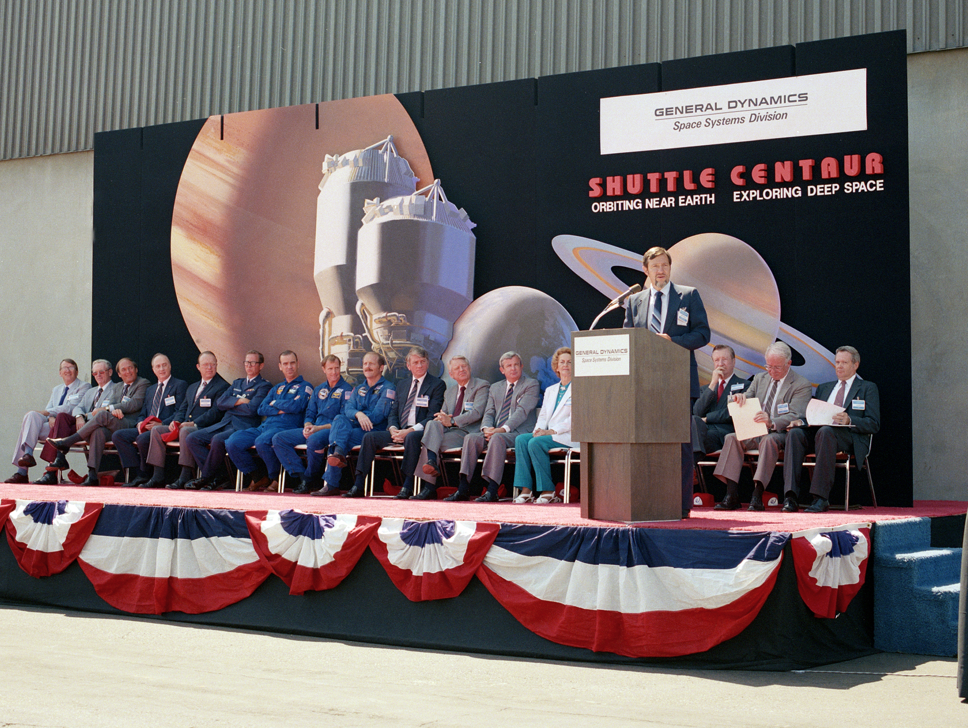
Shuttle-Centaur: Loss of Launch Vehicle Redundancy Leads to DiscordBy Robert Arrighi
“Although the Shuttle/Centaur decision was very difficult to make, it is the proper thing to do, and this is the time to do it.” With those words on June 19, 1986, NASA Administrator James Fletcher canceled the intensive effort to integrate the Centaur upper stage with the Space Shuttle to launch the Galileo and Ulysses spacecraft. The decision, which was tied to increased safety measures following the loss of Challenger several months earlier, brought to the forefront the 1970s decision to launch all U.S. payloads with the Space Shuttle. Continue Reading
Lewis Director Andy Stofan speaks at the Shuttle-Centaur rollout ceremony on August 23, 1985 at General Dynamics’s San Diego headquarters. Galileo mission crew members Dave Walker, Rick Hauck, and John Fabian were among those on stage. NASA A View into NASA’s Response to the Apollo 1 TragedyBy Kate Mankowski
On January 27, 1967, Mission AS-204 (later known as Apollo 1) was conducting a simulated countdown when a fire suddenly broke out in the spacecraft, claiming the lives of astronauts Virgil I. “Gus” Grissom, Edward H. White, and Roger B. Chaffee. The disaster highlighted the risks that come with spaceflight and the work that still needed to be accomplished to meet President Kennedy’s challenge of going to the Moon before the end of the decade. With the complexity of the Apollo spacecraft, discerning the cause of the fire proved to be incredibly difficult. Continue Reading
The Fight to Fund AgRISTARSBy Brad Massey
Robert MacDonald, the manager of NASA’s Large Area Crop Inventory Experiment (LACIE), was not pleased in January 1978 after he read a draft copy of the U.S. General Accounting Office’s (GAO’s) “Crop Forecasting by Satellite: Progress and Problems” report. The draft’s authors argued that LACIE had not achieved its goals of accurately predicting harvest yields in the mid-1970s. Therefore, congressional leaders should “be aware of the disappointing performance of LACIE to date when considering the future direction of NASA’s Landsat program and the plans of the Department of Agriculture.” Continue Reading
The Hubble Space Telescope: The Right Project at the Right TimeBy Jillian Rael
This year, NASA commemorates 35 years of the Hubble Space Telescope’s study of the cosmos. From observations of never-before-seen phenomena within our solar system, to the discovery of distant galaxies, the confirmation of the existence of supermassive black holes, and precision measurements of the universe’s expansion, Hubble has made incredible contributions to science, technology, and even art. Yet, for all its contemporary popularity, the Hubble program initially struggled for congressional approval and consequential funding. For its part, NASA found new ways to compromise and cut costs, while Congress evaluated national priorities and NASA’s other space exploration endeavors against the long-range value of Hubble. Continue Reading
Within the tempestuous Carina Nebula lies “Mystic Mountain.”NASA/ESA/M. Livio/Hubble 20th Anniversary Team Appraisal: The Science and Art of Assessing Donations to the NASA ArchivesBy Alan Arellano
The major functions of an archivist center include appraising, arranging, describing, preserving, and providing access to historical records and documents. While together these are pillars of archival science, they are more of an art than a science in their application, fundamentally necessitating skilled decision making. Throughout the NASA archives, staff members make these decisions day in and day out. Continue Reading
Orbit Shift: How 50 Pegasi b Helped Pull NASA Toward the Stars in the 1990sBy Lois Rosson
On October 20, 1995, the New York Times reported the detection of a distant planet orbiting a Sun-like star. The star, catalogued as 51 Pegasi by John Flamsteed in the 18th century, was visible to the naked eye as part of the constellation Pegasus—and had wobbled on its axis just enough that two Swiss astronomers were able to deduce the presence of another object exerting its gravitational pull on the star’s rotation. The discovery was soon confirmed by other astronomers, and 51 Pegasi b was heralded as the first confirmed exoplanet orbiting a star similar to our own Sun. Continue Reading
Detail from an infographic about 51 Pegasi b and the significance of its discovery.NASA Four, Eight, Fourteen Days: Charles A. Berry, Gemini, and the Critical Steps to Living and Working in SpaceBy Jennifer Ross-Nazzal
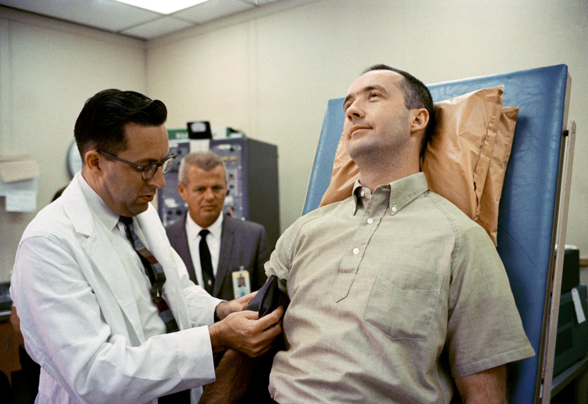
In 1963, critical decisions had to be made about NASA’s upcoming Gemini missions if the nation were to achieve President John F. Kennedy’s lunar goals. Known as the bridge to Apollo, Project Gemini was critical to landing a man on the Moon by the end of the decade and returning him safely to Earth. The project would demonstrate that astronauts could rendezvous and dock their spacecraft to another space vehicle and give flight crews the opportunity to test the planned extravehicular capabilities in preparation for walking on the lunar surface on future Apollo flights. Perhaps most importantly, Gemini had to show that humans could live and work in space for long periods of time, a fiercely debated topic within and outside of the agency. Continue Reading
Dr. Charles Berry prepares to check the blood pressure of James A. McDivitt, Command Pilot for the Gemini IV mission. McDivitt is on the tilt table at the Aero Medical Area, Merritt Island, FL, where he and Gemini IV pilot Edward H. White II underwent preflight physicals in preparation for their four-day spaceflight.NASA Imagining Space: The Life and Art of Robert McCallBy Sandra Johnson
As we walked into Bob McCall’s Arizona home, it quickly became obvious that two talented and creative people lived there. Tasked with interviewing one of the first artists to be invited to join the NASA Art Program, our oral history team quickly realized the session with McCall would include a unique perspective on NASA’s history. We traveled to Arizona in the spring of 2000 to capture interviews with some of the pioneers of spaceflight and had already talked to an eclectic group of subjects in their homes, including a flight controller for both Gemini and Apollo, an astronaut who had flown on both Skylab and Space Shuttle missions, a former NASA center director, and two former Women’s Airforce Service Pilots (WASPs) who ferried airplanes during WWII. However, unlike most interviews, the setting itself provided a rare glimpse into the man and his inspiration. Continue Reading
Inside the Archives: Biomedical Branch FilesBy Alejandra Lopez
The Biomedical Branch Files (1966–2008) in the Johnson Space Center archives showcase the inner workings of a NASA office established to perform testing to provide a better understanding of the impacts of spaceflight on the human body. Ranging from memos and notes to documents and reports, this collection is an invaluable resource on the biomedical research done with NASA’s Apollo, Skylab, Space Shuttle, and Space Station projects. Files in the collection cover work done by groups within the branch such as the Toxicology, Microbiology, Clinical, and Biochemistry Laboratories. It also reveals the branch’s evolution and changes in its decision-making process over the years. Continue Reading
Dr. Carolyn S. Huntoon, shown here in 1972, became the Biomedical Branch’s first chief in 1977.NASA Download the Summer 2025 Edition More Issues of NASA History News and Notes Share Details Last Updated Jun 20, 2025 EditorMichele Ostovar Related Terms Explore More 5 min read NASA History News and Notes–Spring 2025 Article 3 months ago 6 min read NASA History News and Notes – Winter 2024 Article 6 months ago 7 min read NASA History News and Notes – Fall 2024 Article 9 months ago Keep Exploring Discover Related TopicsNASA History
History Publications and Resources
NASA Archives
NASA Oral Histories
NASA Aircraft to Make Low-Altitude Flights in Mid-Atlantic, California
2 min read
Preparations for Next Moonwalk Simulations Underway (and Underwater)From Sunday, June 22 to Wednesday, July 2, two research aircraft will make a series of low-altitude atmospheric research flights near Philadelphia, Baltimore, and some Virginia cities, including Richmond, as well as over the Los Angeles Basin, Salton Sea, and Central Valley in California.
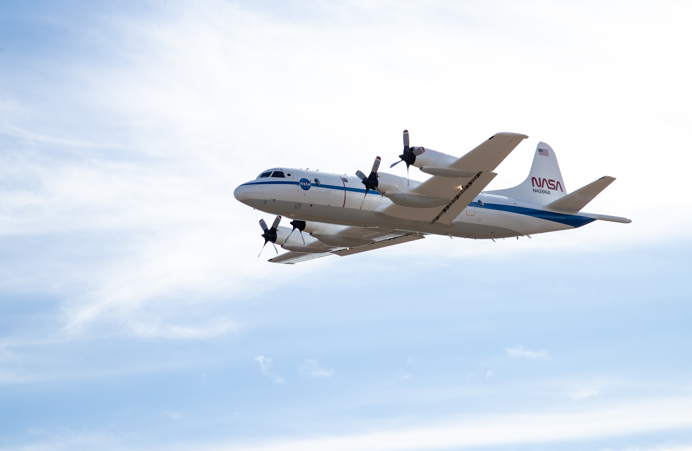
NASA’s P-3 Orion aircraft, based out of the agency’s Wallops Flight Facility in Virginia, along with Dynamic Aviation’s King Air B200 aircraft, will fly over parts of the East and West coasts during the agency’s Student Airborne Research Program. The science flights will be conducted between June 22 and July 2, 2025. NASA/Garon ClarkPilots will operate the aircraft at altitudes lower than typical commercial flights, executing specialized maneuvers such as vertical spirals between 1,000 and 10,000 feet, circling above power plants, landfills, and urban areas. The flights will also include occasional missed approaches at local airports and low-altitude flybys along runways to collect air samples near the surface.
The East Coast flights will be conducted between June 22 and Thursday, June 26 over Baltimore and near Philadelphia, as well as near the Virginia cities of Hampton, Hopewell, and Richmond. The California flights will occur from Sunday, June 29 to July 2.
The flights, part of NASA’s Student Airborne Research Program (SARP), will involve the agency’s Airborne Science Program’s P-3 Orion aircraft (N426NA) and a King Air B200 aircraft (N46L) owned by Dynamic Aviation and contracted by NASA. The program is an eight-week summer internship program that provides undergraduate students with hands-on experience in every aspect of a scientific campaign.
The P-3, operated out of NASA’s Wallops Flight Facility in Virginia, is a four-engine turboprop aircraft outfitted with a six-instrument science payload to support a combined 40 hours of SARP science flights on each U.S. coast. The King Air B200 will fly at the same time as the P-3 but in an independent flight profile. Students will assist in the operation of the science instruments on the aircraft to collect atmospheric data.
“The SARP flights have become mainstays of NASA’s Airborne Science Program, as they expose highly competitive STEM students to real-world data gathering within a dynamic flight environment,” said Brian Bernth, chief of flight operations at NASA Wallops.
“Despite SARP being a learning experience for both the students and mentors alike, our P-3 is being flown and performing maneuvers in some of most complex and restricted airspace in the country,” said Bernth. “Tight coordination and crew resource management is needed to ensure that these flights are executed with precision but also safely.”
For more information about Student Airborne Research Program, visit:
https://science.nasa.gov/earth-science/early-career-opportunities/student-airborne-research-program/
By Olivia Littleton
NASA’s Wallops Flight Facility, Wallops Island, Va.
Hubble Studies Small but Mighty Galaxy
- Hubble Home
- Overview
- Impact & Benefits
- Science
- Observatory
- Team
- Multimedia
- News
- More
2 min read
Hubble Studies Small but Mighty Galaxy This NASA/ESA Hubble Space Telescope features the nearby galaxy NGC 4449. ESA/Hubble & NASA, E. Sabbi, D. Calzetti, A. AloisiThis portrait from the NASA/ESA Hubble Space Telescope puts the nearby galaxy NGC 4449 in the spotlight. The galaxy is situated just 12.5 million light-years away in the constellation Canes Venatici (the Hunting Dogs). It is a member of the M94 galaxy group, which is near the Local Group of galaxies that the Milky Way is part of.
NGC 4449 is a dwarf galaxy, which means that it is far smaller and contains fewer stars than the Milky Way. But don’t let its small size fool you — NGC 4449 packs a punch when it comes to making stars! This galaxy is currently forming new stars at a much faster rate than expected for its size, which makes it a starburst galaxy. Most starburst galaxies churn out stars mainly in their centers, but NGC 4449 is alight with brilliant young stars throughout. Researchers believe that this global burst of star formation came about because of NGC 4449’s interactions with its galactic neighbors. Because NGC 4449 is so close, it provides an excellent opportunity for Hubble to study how interactions between galaxies can influence the formation of new stars.
Hubble released an image of NGC 4449 in 2007. This new version incorporates several additional wavelengths of light that Hubble collected for multiple observing programs. These programs encompass an incredible range of science, from a deep dive into NGC 4449’s star-formation history to the mapping of the brightest, hottest, and most massive stars in more than two dozen nearby galaxies.
The NASA/ESA/CSA James Webb Space Telescope has also observed NGC 4449, revealing in intricate detail the galaxy’s tendrils of dusty gas, glowing from the intense starlight radiated by the flourishing young stars.
Text Credit: ESA/Hubble
Facebook logo @NASAHubble @NASAHubble Instagram logo @NASAHubbleMedia Contact:
Claire Andreoli (claire.andreoli@nasa.gov)
NASA’s Goddard Space Flight Center, Greenbelt, MD
Since its 1990 launch, the Hubble Space Telescope has changed our fundamental understanding of the universe.
Hubble’s Galaxies
Galaxy Details and Mergers
Hubble’s Night Sky Challenge
Curiosity Blog, Sols 4573-4574: Welcome to the Uyuni Quad
- Curiosity Home
- Science
- News and Features
- Multimedia
- Mars Missions
- Mars Home
3 min read
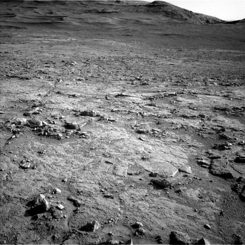
Curiosity Blog, Sols 4573-4574: Welcome to the Uyuni Quad NASA’s Mars rover Curiosity acquired this image, looking southwest toward the distant large boxwork structures in the Uyuni quad, using its Left Navigation Camera on June 15, 2025 — Sol 4571, or Martian day 4,571 of the Mars Science Laboratory mission — at 21:27:38 UTC. NASA/JPL-CaltechWritten by Lauren Edgar, Planetary Geologist at USGS Astrogeology Science Center
Earth planning date: Monday, June 16, 2025
Over the weekend Curiosity successfully wrapped up activities at the “Altadena” drill site and got back on the road. The approximately 48-meter drive (about 157 feet) was successful, and placed the rover in the next mapping quadrangle (informally referred to as a quad).
As a reminder, the rover’s exploration area has been divided into 1.5 kilometer by 1.5 kilometer square quads, and each quad is named after a town of less than 100,000 people. As Curiosity explores features within a quad, we assign informal target names that correspond to geologic formations and features from that town on Earth.
Uyuni, Bolivia, is the gateway city near the world’s largest salt flats (salars), and it seems like an appropriate name as Curiosity explores drier depositional environments higher in the Mount Sharp stratigraphy. The team is excited to use some new target names that will draw from Uyuni and surrounding areas, including the Atacama Desert in Chile, which hosts many Mars analog sites including eolian features, studies of life in extreme environments, and some of the world’s great observatories. A fitting theme for this next phase of exploration!
As for today’s two-sol plan, we have a good balance of contact science, remote sensing, and another long drive. The team planned APXS and MAHLI on a nodular bedrock target named “Flamingo” to assess its chemistry and texture. In the targeted remote sensing block, the science team planned a Mastcam mosaic of “Los Patos” to characterize a depression which may be related to a small impact crater or boxwork structures, along with a Mastcam image of “La Lava” to investigate an interesting dark block. There are also several Mastcam mosaics of nearby troughs to assess active surface processes, and documentation images for ChemCam observations. The plan includes a ChemCam LIBS observation on a target named “Tacos” to assess the local bedrock, and a long-distance RMI mosaic to evaluate sedimentary structures at “Mishe Mokwa” butte. Then the rover will drive about 56 meters (about 184 feet) to the southwest, and take post-drive imaging to prepare for the next plan. On the second sol, Curiosity will complete a ChemCam calibration target activity, a Mastcam data management activity, and a few Navcam activities to monitor clouds and dust in the atmosphere.
We’re looking forward to exploring more of Uyuni as we work our way toward the larger exposure of boxwork structures that lie ahead, and the clues they hold to ancient Mars conditions.
For more Curiosity blog posts, visit MSL Mission Updates
Learn more about Curiosity’s science instruments
Share Details Last Updated Jun 18, 2025 Related Terms Explore More 3 min read Curiosity Blog, Sols 4570-4572: A Fond Farewell, With a Side of Frost
Article
4 days ago
2 min read Curiosity Blog, Sols 4568-4569: A Close Look at the Altadena Drill Hole and Tailings
Article
5 days ago
2 min read Curiosity Blog, Sols 4566-4567: Drilling Success
Article
7 days ago
Keep Exploring Discover More Topics From NASA Mars
Mars is the fourth planet from the Sun, and the seventh largest. It’s the only planet we know of inhabited…
All Mars Resources
Explore this collection of Mars images, videos, resources, PDFs, and toolkits. Discover valuable content designed to inform, educate, and inspire,…
Rover Basics
Each robotic explorer sent to the Red Planet has its own unique capabilities driven by science. Many attributes of a…
Mars Exploration: Science Goals
The key to understanding the past, present or future potential for life on Mars can be found in NASA’s four…
NASA Astronauts to Answer Questions from Students in New York, Utah
Students from New York and Utah will hear from NASA astronauts aboard the International Space Station as they answer prerecorded questions in two separate events.
At 11:30 a.m. EDT on Monday, June 23, NASA astronauts Nichole Ayers and Anne McClain will answer questions submitted by students from P.S. 71 Forest Elementary School in Ridgewood, New York. Media interested in covering the event must RSVP by 5 p.m. Friday, June 20, to Regina Beshay at: rbeshay2@school.nyc.gov or 347-740-6165.
At 11:05 a.m. on Friday, June 27, Ayers and McClain will answer questions submitted by students from Douglas Space and Science Foundation, Inc., in Layton, Utah. Media interested in covering the event must RSVP by 5 p.m. Wednesday, June 25, to Sarah Merrill at: sarahmonique@gmail.com or 805-743-3341.
Watch the 20-minute Earth-to-space calls on NASA STEM YouTube Channel.
P.S. 71 Forest Elementary School will host kindergarten through fifth grade students. Douglas Space and Science Foundation will host participants from the Science, Technology, Achievement Research camp. Both events aim to inspire students to imagine a future in science, technology, engineering, and mathematics careers through ongoing collaborations, mentorship, and hands-on learning experiences.
For nearly 25 years, astronauts have continuously lived and worked aboard the space station, testing technologies, performing science, and developing skills needed to explore farther from Earth. Astronauts aboard the orbiting laboratory communicate with NASA’s Mission Control Center in Houston 24 hours a day through SCaN’s (Space Communications and Navigation) Near Space Network.
Important research and technology investigations taking place aboard the space station benefit people on Earth and lays the groundwork for other agency missions. As part of NASA’s Artemis campaign, the agency will send astronauts to the Moon to prepare for future human exploration of Mars; inspiring explorers and ensuring the United States continues to lead in space exploration and discovery.
See videos of astronauts aboard the space station at:
https://www.nasa.gov/stemonstation
-end-
Gerelle Dodson
Headquarters, Washington
202-358-1600
gerelle.q.dodson@nasa.gov
Sandra Jones
Johnson Space Center, Houston
281-483-5111
sandra.p.jones@nasa.gov
NASA’s Human Exploration Rover Challenge
Two students guide their rover through an obstacle course in this April 11, 2025, image from the 2025 Human Exploration Rover Challenge. The annual engineering competition – one of NASA’s longest standing student challenges – is in its 31st year. This year’s competition challenged teams to design, build, and test a lunar rover powered by either human pilots or remote control. More than 500 students with 75 teams from around the world participated, representing 35 colleges and universities, 38 high schools, and two middle schools from 20 states, Puerto Rico, and 16 other nations.
Image credit: NASA/Charles Beason
Digital Information Platform Library
1 min read
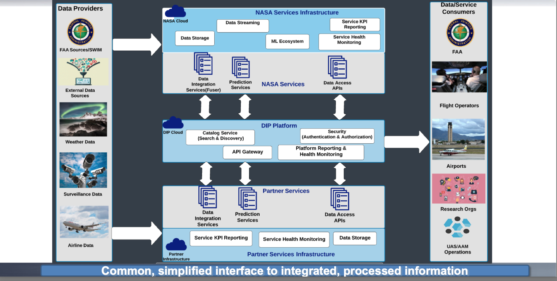
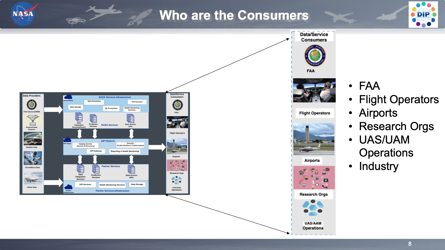
Preparations for Next Moonwalk Simulations Underway (and Underwater) LibraryScientific papers, industry forum presentations, and videos covering the concepts used in the digital information platform are available to the public. For those interested in a deeper understanding of the technical workings of DIP, please refer to these resources.
NewslettersApril 2025
December 2024
August 2024
June 2024
March 2024
November 2023
NASA Partners With Airlines to Save Fuel, Reduce Flight Delays
NASA Flight Rerouting Tool Curbs Delays, Emissions
NASA Cloud-Based Platform Could Help Streamline, Improve Air Traffic
NASA Machine Learning Air Traffic Software Saves Fuel
Technical Papers Events Fuser information from Airspace Technical Demonstration-2 industry day workshopVideo recordings of the presentations at the ATD-2 Industry Days
Online Videos2023 Jan 21 – AIAA LA LV NASA’s Digital Information Platform DIP to Accelerate NAS Transformation
DIP Collaborative Digital Departure Reroute Overview
Facebook logo @NASA@NASAaero@NASAes @NASA@NASAaero@NASA_es Instagram logo @NASA@NASAaero@NASA_es Linkedin logo @NASA Explore More 1 min read DIP Events Article 1 day ago 1 min read DIP Request for Information (RFI) Information Session Article 1 day ago 2 min read DIP RFI Outbrief Session Article 1 day ago Keep Exploring Discover More Topics From NASAMissions
Humans In Space
Aeronautics STEM
Explore NASA’s History
Share Details Last Updated Jun 18, 2025 EditorLillian GipsonContactJim Bankejim.banke@nasa.gov Related TermsDIP Events
1 min read
Preparations for Next Moonwalk Simulations Underway (and Underwater) Getty ImagesNovember 20, 2024 at 10:00 AM EST
Digital Information Platform Virtual Workshop: A Virtual Workshop on Service Quality, Data Governance, Cybersecurity, and Interoperability
June 28, 2023 at 10:00 AM EDT
DIP Information Session: Announcement of Collaborative Opportunity (ACO) for Service Providers
July 27, 2022 at 10:00 AM EDT
DIP Announcement of Collaborative Opportunity (ACO) for Flight Operators
February 23, 2022 at 10:00 AM EST
DIP Workshop Series 3: DIP for Consumers
January 12, 2022 at 10:00 AM EST
DIP Workshop 2: DIP for Service Providers
November 17, 2021 at 10:00 AM EST
DIP Workshop Series 1: DIP Architecture and Data Integration Services
August 18, 2021 at 10:00 AM EDT
DIP RFI Outbrief Session
April 14, 2021 at 11:00 AM EDT
DIP Request for Information (RFI) Information Session
Digital Information Platform (DIP)
Facebook logo @NASA@NASAaero@NASA_es @NASA@NASAaero@NASAes Instagram logo @NASA@NASAaero@NASAes Linkedin logo @NASA Explore More 1 min read Digital Information Platform Library Article 1 day ago 1 min read DIP Request for Information (RFI) Information Session Article 1 day ago 2 min read DIP RFI Outbrief Session Article 1 day ago Keep Exploring Discover More Topics From NASAMissions
Humans In Space
Solar System ExplorationEyes on the Solar System
Explore NASA’s History
Share Details Last Updated Jun 18, 2025 EditorLillian GipsonContactJim Bankejim.banke@nasa.gov Related TermsDIP Request for Information (RFI) Information Session
1 min read
Preparations for Next Moonwalk Simulations Underway (and Underwater) StartApril 14, 2021 at 11:00 AM EDTEnd
April 14, 2021 at 1:00 PM EDT
NASA’s Digital Information Platform (DIP) sub-project as part of Air Traffic Management -eXploration (ATM-X) project has recently released the Request for Information (RFI) to obtain information to define collaboration strategy and identify community needs and goals. As a follow-on activity, DIP hosted an online information session to provide the stakeholder community with background of DIP sub-project, example use cases, collaboration approach, and areas of potential contributions both from NASA and interested parties. The purpose of the information session was to help the community understand the scope of the sub-project and thus respond to the RFI in a meaningful way.
- Date: Wednesday, April 14, 2021
- Time: 11 am – 1 pm (Pacific Time)
- DIP Vision and Motivation
- Example Use Cases
- Collaboration Approach
- Demonstration Progression
- Information Requested
- RFI Instructions to Submit
- Question & Answer
- Presentation slides
- Session Recording
- Request materials via email (arc-dip-ext@mail.nasa.gov)
Digital Information Platform Events
Facebook logo @NASA@NASAaero@NASA_es @NASA@NASAaero@NASAes Instagram logo @NASA@NASAaero@NASAes Linkedin logo @NASA Explore More 1 min read Digital Information Platform Library Article 1 day ago 1 min read DIP Events Article 1 day ago 2 min read DIP RFI Outbrief Session Article 1 day ago Keep Exploring Discover More Topics From NASAMissions
Humans In Space
Solar System ExplorationEyes on the Solar System
Explore NASA’s History
Share Details Last Updated Jun 18, 2025 EditorLillian GipsonContactJim Bankejim.banke@nasa.gov Related TermsDIP RFI Outbrief Session
2 min read
Preparations for Next Moonwalk Simulations Underway (and Underwater) StartAugust 18, 2021 at 10:00 AM ESTEnd
August 18, 2021 at 12:00 PM EST DIP RFI Outbrief Session
NASA’s Digital Information Platform (DIP) sub-project as part of Air Traffic Management -eXploration (ATM-X) project has received responses to the Request for Information (RFI) from aviation community. As a follow-on activity, DIP is hosting an online information session to brief out to the community with the summary of RFI inputs as well as the latest updates on DIP sub-project planning. The purpose of this session is to share the valuable inputs from the RFI responses on data & service needs for airspace operations, recommended use cases for DIP collaborative demos, and potential data and technology services that can be provided by the DIP platform through NASA-industry collaboration.
Interested parties are encouraged to register for the outbrief session by submitting the registration form shown below. The outbrief session will be organized by a series of presentation followed by a Q&A session, and will be available through MS Teams.
- Date: Wednesday, August 18, 2021
- Time: 10 am – 12 pm Pacific
- DIP Overview
- Partner Engagement Strategy
- Request for Information
- Responses Summary
- Demo Plan Overview
- Next Steps,
- Q&A
- Presentation slides
- Session Recording
- Request materials via email (arc-dip-ext@mail.nasa.gov)
Digital Information Platform Events
Facebook logo @NASA@NASAaero@NASA_es @NASA@NASAaero@NASAes Instagram logo @NASA@NASAaero@NASAes Linkedin logo @NASA Explore More 1 min read Digital Information Platform Library Article 1 day ago 1 min read DIP Events Article 1 day ago 1 min read DIP Request for Information (RFI) Information Session Article 1 day ago Keep Exploring Discover More Topics From NASAMissions
Humans In Space
Solar System ExplorationEyes on the Solar System
Explore NASA’s History
Share Details Last Updated Jun 18, 2025 EditorLillian GipsonContactJim Bankejim.banke@nasa.gov Related TermsDIP Workshop Series 1: DIP Architecture and Date Integration Services
3 min read
Preparations for Next Moonwalk Simulations Underway (and Underwater) NASA / DIP StartNovember 17, 2021 at 10:00 AM ESTEnd
November 17, 2021 at 12:00 PM EST Workshop Series: What It’s About
The Digital Information Platform (DIP) workshop series is intended to provide a deeper dive and a closer look at some of the core features being developed by the DIP sub-project under ATM-X.
These workshops will give insight into DIP development, technology, and assumptions as well as providing a forum for engaging with the DIP team to pose questions and provide feedback on proposed designs. Engagement with the broader aviation community is a critical component to success of the DIP sub-project!
There will be several workshops within this series spanning a variety of topics. Participants are encouraged to sign up for any workshop topics they feel they could contribute to or provide feedback on.
Please keep an eye on the DIP homepage, under the upcoming events section, for future announcements of additional workshop topics!
Workshop #1: DIP Architecture and Data Integration ServicesThis workshop will cover DIP architecture and data integration services. Participants will get a look at how the DIP architecture is set-up as well as how data integration services are planned to be hosted on the platform.
The DIP architecture review is intended to cover how DIP was envisioned and how DIP is being developed to address data needs across the industry. Participants will have a chance to provide feedback on the DIP architecture and gain insight into how one might interface with the DIP to send or receive data.
The data integration services portion is intended to cover DIP’s technical approach to data integration. As an example implementation, there will be a first look at possible data fusion on the platform , including utilizing NASA’s Fuser, and tailoring for industry data consumers. Descriptions, at a high-level, of input to and output of the Fuser will also be discussed.
Who Should Register?Participants interested in partnering with DIP and registering their service with the DIP platform are highly encouraged to attend this workshop. This is a unique opportunity for the aviation community to provide feedback and input on how this platform is structured to meet your needs.
Data and service consumers as well as data and service providers are encouraged to attend this workshop to provide their feedback and input for DIP development.
Participants looking to gain insight into upcoming DIP demonstrations or to learn more about DIP are encouraged to attend this workshop.
Resources- Presentation slides
- Session Recording
- Request materials via email (arc-dip-ext@mail.nasa.gov)
Digital Information Platform Events
Facebook logo @NASA@NASAaero@NASA_es @NASA@NASAaero@NASAes Instagram logo @NASA@NASAaero@NASAes Linkedin logo @NASA Explore More 1 min read Digital Information Platform Library Article 1 day ago 1 min read DIP Events Article 1 day ago 1 min read DIP Request for Information (RFI) Information Session Article 1 day ago Keep Exploring Discover More Topics From NASAMissions
Humans In Space
Solar System ExplorationEyes on the Solar System
Explore NASA’s History
Share Details Last Updated Jun 18, 2025 EditorLillian GipsonContactJim Bankejim.banke@nasa.gov Related TermsDIP Workshop Series 2: DIP for Service Providers
2 min read
Preparations for Next Moonwalk Simulations Underway (and Underwater) StartJanuary 12, 2022 at 10:00 AM ESTEnd
January 12, 2022 at 12:00 PM EST Workshop Series: What It’s About
The Digital Information Platform (DIP) workshop series intends to provide a deeper dive and a closer look at some of the core features being developed by the DIP sub-project under ATM-X.
These workshops will give insight into DIP development, technology, and assumptions as well as providing a forum for engaging with the DIP team to pose questions and provide feedback on proposed designs. Engagement with the broader aviation community is a critical component to success of the DIP sub-project!
There will be several workshops within this series spanning a variety of topics. Participants are encouraged to sign up for any workshop topics they feel they could contribute to or provide feedback on.
Please keep an eye on the DIP homepage, under the upcoming events section, for future announcements of additional workshop topics!
Workshop #2: DIP for Service ProvidersThis workshop will cover topics related to Service Providers. Participants will get a look at how the DIP architecture supports the onboarding process as well as how NASA services are planned to be made available via the platform.
The DIP for Service Providers is intended to cover how DIP was envisioned with regards to the following:
- Onboarding
- Announcement for Collaborative Opportunity, Space Act Agreements
- Interconnection Security Agreements & Authentication
- Catalog Service Capabilities
- Service Registration, Discovery & Try it now feature
- API Requirements, Service Specifications
- NASA Services and Access Points
- Machine Learning Services
- Data Access APIs
- Streaming Fuser Data
- S3 Bucket
- Data Requirements for Service Providers
Participants interested in partnering with DIP and registering their service with the DIP platform are highly encouraged to attend this workshop. This is a unique opportunity for the aviation community to provide feedback and input on how this platform is structured to meet your needs.
Data and service consumers as well as data and service providers are encouraged to attend this workshop to provide their feedback and input for DIP development.
Participants looking to gain insight into upcoming DIP demonstrations or to learn more about DIP are encouraged to attend this workshop.
Agenda- Onboarding
- Catalog Service Capabilities
- API Requirements, Service Specifications
- NASA Services and Access Points
- Data Requirements for Service Providers
- Presentation slides
- Session Recording
- Request materials via email (arc-dip-ext@mail.nasa.gov)
Digital Information Platform Events
Facebook logo @NASA@NASAaero@NASA_es @NASA@NASAaero@NASAes Instagram logo @NASA@NASAaero@NASAes Linkedin logo @NASA Explore More 1 min read Digital Information Platform Library Article 1 day ago 1 min read DIP Events Article 1 day ago 1 min read DIP Request for Information (RFI) Information Session Article 1 day ago Keep Exploring Discover More Topics From NASAMissions
Humans In Space
Solar System ExplorationEyes on the Solar System
Explore NASA’s History
Share Details Last Updated Jun 18, 2025 EditorLillian GipsonContactJim Bankejim.banke@nasa.gov Related TermsNASA to Gather In-Flight Imagery of Commercial Test Capsule Re-Entry
A NASA team specializing in collecting imagery-based engineering datasets from spacecraft during launch and reentry is supporting a European aerospace company’s upcoming mission to return a subscale demonstration capsule from space.
NASA’s Scientifically Calibrated In-Flight Imagery (SCIFLI) team supports a broad range of mission needs across the agency, including Artemis, science missions like OSIRIS-REx (Origins, Spectral Interpretation, Resource Identification, and Security – Regolith Explorer), and NASA’s Commercial Crew Program. The SCIFLI team also supports other commercial space efforts, helping to develop and strengthen public-private partnerships as NASA works to advance exploration, further cooperation, and open space to more science, people, and opportunities.
Later this month, SCIFLI intends to gather data on The Exploration Company’s Mission Possible capsule as it returns to Earth following the launch on a SpaceX Falcon 9 rocket. One of the key instruments SCIFLI will employ is a spectrometer that detects light radiating from the capsule’s surface, which researchers can use to determine the surface temperature of the spacecraft. Traditionally, much of this information comes from advanced Computational Fluid Dynamics modeling of what happens when objects of various sizes, shapes, and materials enter different atmospheres, such as those on Earth, Mars, or Venus.
“While very powerful, there is still some uncertainty in these Computational Fluid Dynamics models. Real-world measurements made by the SCIFLI team help NASA researchers refine their models, meaning better performance for sustained flight, higher safety margins for crew returning from the Moon or Mars, or landing more mass safely while exploring other planets,” said Carey Scott, SCIFLI capability lead at NASA’s Langley Research Center in Hampton, Virginia.
A rendering of a space capsule from The Exploration Company re-entering Earth’s atmosphere.Image courtesy of The Exploration CompanyThe Exploration Company
The SCIFLI team will be staged in Hawaii and will fly aboard an agency Gulfstream III aircraft during the re-entry of Mission Possible over the Pacific Ocean.
“The data will provide The Exploration Company with a little bit of redundancy and a different perspective — a decoupled data package, if you will — from their onboard sensors,” said Scott.
From the Gulfstream, SCIFLI will have the spectrometer and an ultra-high-definition telescope trained on Mission Possible. The observation may be challenging since the team will be tracking the capsule against the bright daytime sky. Researchers expect to be able to acquire the capsule shortly after entry interface, the point at roughly 200,000 feet, where the atmosphere becomes thick enough to begin interacting with a capsule, producing compressive effects such as heating, a shock layer, and the emission of photons, or light.
Real-world measurements made by the SCIFLI team help NASA researchers refine their models, meaning better performance for sustained flight, higher safety margins for crew returning from the Moon or Mars, or landing more mass safely while exploring other planets.Carey Scott
SCIFLI Capability Lead
In addition to spectrometer data on Mission Possible’s thermal protection system, SCIFLI will capture imagery of the parachute system opening. First, a small drogue chute deploys to slow the capsule from supersonic to subsonic, followed by the deployment of a main parachute. Lastly, cloud-cover permitting, the team plans to image splashdown in the Pacific, which will help a recovery vessel reach the capsule as quickly as possible.
If flying over the ocean and capturing imagery of a small capsule as it zips through the atmosphere during the day sounds difficult, it is. But this mission, like all SCIFLI’s assignments, has been carefully modeled, choreographed, and rehearsed in the months and weeks leading up to the mission. There will even be a full-dress rehearsal in the days just before launch.
Not that there aren’t always a few anxious moments right as the entry interface is imminent and the team is looking out for its target. According to Scott, once the target is acquired, the SCIFLI team has its procedures nailed down to a — pardon the pun — science.
“We rehearse, and we rehearse, and we rehearse until it’s almost memorized,” he said.
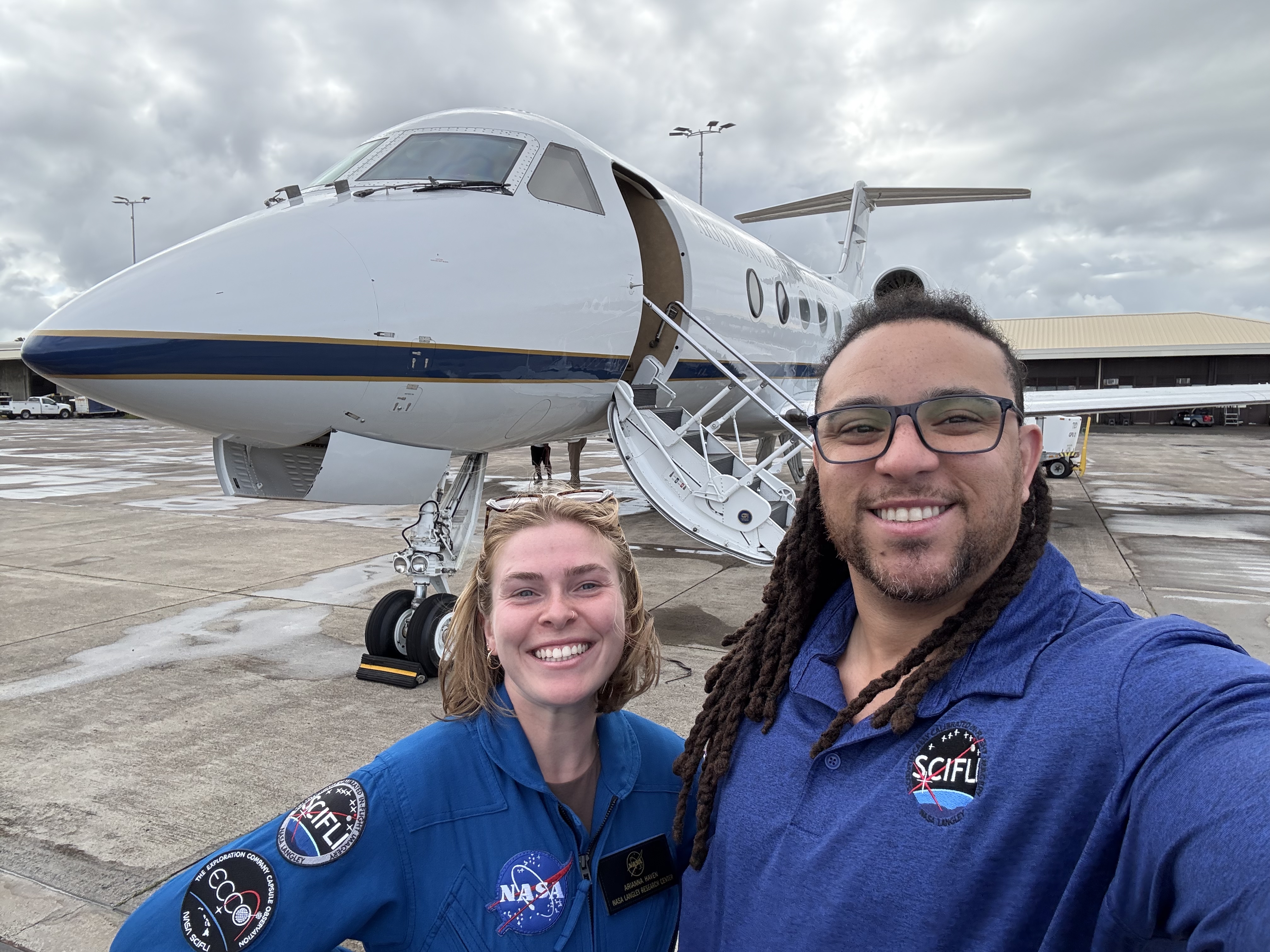
Ari Haven, left, asset coodinator for SCIFLI’s support of Mission Possible, and Carey Scott, principal engineer for the mission, in front of the G-III aircraft the team will fly on.Credit: NASA/Carey ScottNASA/Carey Scott
The Exploration Company, headquartered in Munich, Germany, and Bordeaux,
France, enlisted NASA’s support through a reimbursable Space Act Agreement and will use SCIFLI data to advance future capsule designs.
“Working with NASA on this mission has been a real highlight for our team. It shows what’s possible when people from different parts of the world come together with a shared goal,” said Najwa Naimy, chief program officer at The Exploration Company. “What the SCIFLI team is doing to spot and track our capsule in broad daylight, over the open ocean, is incredibly impressive. We’re learning from each other, building trust, and making real progress together.”
NASA Langley is known for its expertise in engineering, characterizing, and developing spacecraft systems for entry, descent, and landing. The Gulfstream III aircraft is operated by the Flight Operations Directorate at NASA’s Armstrong Flight Research Center in Edwards, California.
Share Details Last Updated Jun 19, 2025 EditorJoe AtkinsonContactJoe Atkinsonjoseph.s.atkinson@nasa.govLocationNASA Langley Research Center Related Terms Explore More 4 min read NASA Tech to Measure Heat, Strain in Hypersonic Flight Article 1 day ago 4 min read Career Exploration: Using Ingenuity and Innovation to Create ‘Memory Metals’ Article 2 days ago 3 min read NASA Engineers Simulate Lunar Lighting for Artemis III Moon Landing Article 2 days ago Keep Exploring Discover More Topics From NASAMissions
Humans in Space
Climate Change
Solar System
DIP Workshop Series 3: DIP for Consumers
2 min read
Preparations for Next Moonwalk Simulations Underway (and Underwater) NASA / DIP StartFebruary 23, 2022 at 10:00 AM EDTEnd
February 23, 2022 at 12:00 PM EST Workshop Series: What It’s About
The Digital Information Platform (DIP) workshop series intends to provide a deeper dive and a closer look at some of the core features being developed by the DIP sub-project under ATM-X.
These workshops will give insight into DIP development, technology, and assumptions as well as providing a forum for engaging with the DIP team to pose questions and provide feedback on proposed designs. Engagement with the broader aviation community is a critical component to success of the DIP sub-project!
There will be several workshops within this series spanning a variety of topics. Participants are encouraged to sign up for any workshop topics they feel they could contribute to or provide feedback on.
Please keep an eye on the DIP homepage, under the upcoming events section, for future announcements of additional workshop topics!
Workshop #3: DIP for Flight Operators and ConsumersThis workshop will cover topics related to Service Providers. Participants will get a look at how the DIP architecture supports the onboarding process as well as how NASA services are planned to be made available via the platform.
The DIP for Service Providers is intended to cover how DIP was envisioned with regards to the following:
- Consumer Onboarding
- How to find and invoke services
- Showcase Demos
- Data integration services
- Data analytics using ML/AI technologies
- Progression of CDDR capabilities
- Performance Metrics
- Tech Dev Plan and Schedule updates
- Q/A
Participants interested in partnering with DIP and consuming services from the DIP platform are highly encouraged to attend this workshop. This is a unique opportunity for the aviation community to provide feedback and input on how this platform is structured to meet your needs.
Data and service consumers as well as data and service providers are encouraged to attend this workshop to provide their feedback and input for DIP development.
Participants looking to gain insight into upcoming DIP demonstrations or to learn more about DIP are encouraged to attend this workshop.
Resources- Presentation slides
- Session Recording
- Request materials via email (arc-dip-ext@mail.nasa.gov)
Digital Information Platform Events
Facebook logo @NASA@NASAaero@NASA_es @NASA@NASAaero@NASAes Instagram logo @NASA@NASAaero@NASAes Linkedin logo @NASA Explore More 1 min read Digital Information Platform Library Article 3 hours ago 1 min read DIP Events Article 3 hours ago 1 min read DIP Request for Information (RFI) Information Session Article 3 hours ago Keep Exploring Discover More Topics From NASAMissions
Humans In Space
Solar System ExplorationEyes on the Solar System
Explore NASA’s History
Share Details Last Updated Jun 18, 2025 EditorLillian GipsonContactJim Bankejim.banke@nasa.gov Related TermsNASA, German Aerospace Center to Expand Artemis Campaign Cooperation
While attending the Paris Air Show June 16, NASA acting Administrator Janet Petro signed an agreement with DLR (German Aerospace Center, or Deutsches Zentrum für Luft- und Raumfahrt) to continue a partnership in space medicine research. This renewed collaboration builds on previous radiation mitigation efforts for human spaceflight. As NASA advances the Trump-Vance Administration’s goals for exploration on the Moon and Mars, minimizing exposure to space radiation is one of the key areas the agency is working to protect crew on long duration missions.
With this agreement, DLR will leverage its human spaceflight expertise and provide new radiation sensors aboard the Orion spacecraft during NASA’s Artemis II mission, building on previous work in this area during the Artemis I mission. Scheduled for launch no later than April 2026, Artemis II will mark the first test flight with crew under Artemis.
“In keeping with the historic agreements NASA has made with international partners as a part of Artemis, I am pleased to sign a new NASA-DLR joint agreement today, to enable radiation research aboard Artemis II,” said acting NASA Administrator Janet Petro. “The German Aerospace Center has been a valuable partner in Artemis, having previously worked with NASA to test technology critical to our understanding of radiation on humans aboard an Orion spacecraft on Artemis I and providing a CubeSat as part of Artemis II. Following a productive meeting between President Trump and German Chancellor Merz earlier this month, I am excited to build upon our great partnership with Germany.”
During the Artemis II mission’s planned 10-day journey around the Moon and back, four of DLR’s newly developed M-42 extended (M-42 EXT) radiation detectors will be on board, contributing vital data to support astronaut safety. This next-generation device represents a new phase of research as NASA and DLR continue working together to safeguard human health in space.
Under the leadership of President Trump, America’s Artemis campaign has reignited NASA’s ambition, sparking international cooperation and cutting-edge innovation. The continued partnership with DLR and the deployment of their advanced M-42 EXT radiation detectors aboard Artemis II exemplifies how the Trump-Vance Administration is leading a Golden Era of Exploration and Innovation that puts American astronauts on the path to the Moon, Mars, and beyond.
“To develop effective protective measures against the impact of space radiation on the human body, comprehensive and coherent radiation measurements in open space are essential,” says Anke Pagels-Kerp, divisional board member for space at DLR. “At the end of 2022, Artemis I carried 12,000 passive and 16 active detectors inside the Helga and Zohar mannequins, which flew aboard the Orion spacecraft as part of DLR’s MARE project. These provided a valuable dataset – the first continuous radiation measurements ever recorded beyond low Earth orbit. We are now excited to take the next step together with NASA and send our upgraded radiation detectors around the Moon on the Artemis II mission.”
Through the Artemis campaign, the agency will establish a long-term presence on the Moon for scientific exploration with our commercial and international partners, learn how to live and work away from home, and prepare for future human exploration of Mars.
For more information about Artemis, visit:
-end-
Bethany Stevens / Rachel Kraft
Headquarters
202-358-1600
bethany.c.stevens@nasa.gv / rachel.h.kraft@nasa.gov
A New Hybrid System Could Enable Spacecraft Attitude Control Systems to Perform Scientific Measurements
A NASA-sponsored team is creating a new approach to measure magnetic fields by developing a new system that can both take scientific measurements and provide spacecraft attitude control functions. This new system is small, lightweight, and can be accommodated onboard the spacecraft, eliminating the need for the boom structure that is typically required to measure Earth’s magnetic field, thus allowing smaller, lower-cost spacecraft to take these measurements. In fact, this new system could not only enable small spacecraft to measure the magnetic field, it could replace the standard attitude control systems in future spacecraft that orbit Earth, allowing them to provide the important global measurements that enable us to understand how Earth’s magnetic field protects us from dangerous solar particles.
Photo of the aurora (taken in Alaska) showing small scale features that are often present. Credit: NASA/Sebastian Saarloos
Solar storms drive space weather that threatens our many assets in space and can also disrupt Earth’s upper atmosphere impacting our communications and power grids. Thankfully, the Earth’s magnetic field protects us and funnels much of that energy into the north and south poles creating aurorae. The aurorae are a beautiful display of the electromagnetic energy and currents that flow throughout the Earth’s space environment. They often have small-scale magnetic features that affect the total energy flowing through the system. Observing these small features requires multiple simultaneous observations over a broad range of spatial and temporal scales, which can be accomplished by constellations of small spacecraft.
To enable such constellations, NASA is developing an innovative hybrid magnetometer that makes both direct current (DC) and alternating current (AC) magnetic measurements and is embedded in the spacecraft’s attitude determination and control system (ADCS)—the system that enables the satellite to know and control where it is pointing. High-performance, low SWAP+C (low-size, weight and power + cost) instruments are required, as is the ability to manufacture and test large numbers of these instruments within a typical flight build schedule. Future commercial or scientific satellites could use these small, lightweight embedded hybrid magnetometers to take the types of measurements that will expand our understanding of space weather and how Earth’s magnetic field responds to solar storms
It is typically not possible to take research-quality DC and AC magnetic measurements using sensors within an ADCS since the ADCS is inside the spacecraft and near contaminating sources of magnetic noise such as magnetic torque rods—the electromagnets that generate a magnetic field and push against the Earth’s magnetic field to control the orientation of a spacecraft. Previous missions that have flown both DC and AC magnetometers placed them on long booms pointing in opposite directions from the satellite to keep the sensors as far from the spacecraft and each other as possible. In addition, the typical magnetometer used by an ADCS to measure the orientation of the spacecraft with respect to the geomagnetic field does not sample fast enough to measure the high-frequency signals needed to make magnetic field observations.
A NASA-sponsored team at the University of Michigan is developing a new hybrid magnetometer and attitude determination and control system (HyMag-ADCS) that is a low-SWAP single package that can be integrated into a spacecraft without booms. HyMag-ADCS consists of a three-axis search coil AC magnetometer and a three-axis Quad-Mag DC magnetometer. The Quad-Mag DC magnetometer uses machine learning to enable boomless DC magnetometery, and the hybrid search-coil AC magnetometer includes attitude determination torque rods to enable the single 1U volume (103 cm) system to perform ADCS functions as well as collect science measurements.
The magnetic torque rod and search coil sensor (left) and the Quad-Mag magnetometer prototype (right). Credit: Mark MoldwinThe HyMag-ADCS team is incorporating the following technologies into the system to ensure success.
Quad-Mag Hardware: The Quad-Mag DC magnetometer consists of four magneto-inductive magnetometers and a space-qualified micro-controller mounted on a single CubeSat form factor (10 x 10 cm) printed circuit board. These two types of devices are commercially available. Combining multiple sensors on a single board increases the instrument’s sensitivity by a factor of two compared to using a single sensor. In addition, the distributed sensors enable noise identification on small satellites, providing the science-grade magnetometer sensing that is key for both magnetic field measurements and attitude determination. The same type of magnetometer is part of the NASA Artemis Lunar Gateway Heliophysics Environmental and Radiation Measurement Experiment Suite (HERMES) Noisy Environment Magnetometer in a Small Integrated System (NEMISIS) magnetometer scheduled for launch in early 2027.
Dual-use Electromagnetic Rods: The HyMag-ADCS team is using search coil electronics and torque rod electronics that were developed for other efforts in a new way. Use of these two electronics systems enables the electromagnetic rods in the HyMag-ADCS system to be used in two different ways—as torque rods for attitude determination and as search coils to make scientific measurements. The search coil electronics were designed for ground-based measurements to observe ultra-low frequency signals up to a few kHz that are generated by magnetic beacons for indoor localization. The torque rod electronics were designed for use on CubeSats and have flown on several University of Michigan CubeSats (e.g., CubeSat-investigating Atmospheric Density Response to Extreme driving [CADRE]). The HyMag-ADCS concept is to use the torque rod electronics as needed for attitude control and use the search coil electronics the rest of the time to make scientific AC magnetic field measurements.
Machine Learning Algorithms for Spacecraft Noise Identification: Applying machine learning to these distributed sensors will autonomously remove noise generated by the spacecraft. The team is developing a powerful Unsupervised Blind Source Separation (UBSS) algorithm and a new method called Wavelet Adaptive Interference Cancellation for Underdetermined Platforms (WAIC-UP) to perform this task, and this method has already been demonstrated in simulation and the lab.
The HyMag-ADCS system is early in its development stage, and a complete engineering design unit is under development. The project is being completed primarily with undergraduate and graduate students, providing hands-on experiential training for upcoming scientists and engineers.
Early career electrical engineer Julio Vata and PhD student Jhanene Heying-Melendrez with art student resident Ana Trujillo Garcia in the magnetometer lab testing prototypes. Credit: Mark MoldwinFor additional details, see the entry for this project on NASA TechPort .
Project Lead: Prof. Mark Moldwin, University of Michigan
Sponsoring Organization: NASA Heliophysics Division’s Heliophysics Technology and Instrument Development for Science (H-TIDeS) program.
Share Details Last Updated Jun 17, 2025 Related Terms Explore More 2 min read Hubble Studies a Spiral’s Supernova SceneArticle
4 days ago
5 min read NASA Launching Rockets Into Radio-Disrupting Clouds
Article
5 days ago
2 min read Hubble Captures Starry Spectacle
Article
2 weeks ago
