
NASA News
Advances in NASA Imaging Changed How World Sees Mars
6 min read
Preparations for Next Moonwalk Simulations Underway (and Underwater) NASA’s Mariner 4 captured the first-ever close-up image of Mars on July 14, 1965. While waiting for the data to be processed into the image (inset at right), team members hand-colored strips of paper that the data was printed on, assigning hues to value ranges. The result is on display at JPL.NASA/JPL-CaltechSixty years ago, NASA’s Mariner 4 captured groundbreaking views of the Red Planet, leading to a steady stream of advances in the cameras used to study other worlds.
In 1965, NASA’s Mariner 4 mission brought Mars into American living rooms, where TV sets showed fuzzy black-and-white images of a cratered landscape. The spacecraft took 21 complete pictures — the first ever captured of another planet — as it flew by as close as 6,118 miles (9,846 kilometers) above the surface.
The mission team couldn’t wait to see what the camera aboard the spacecraft would return. When the actual images were delayed, they went so far as to create a color-by-numbers image, assigning hues to specific values in the data.
Their handiwork wasn’t far off, and the barren landscape Mariner 4 captured ignited the imaginations of future scientists and engineers who would go on to work on a succession of missions, each revealing Mars in a way it had never been seen before.
Millions of Mars images have been taken since then, many of which are captivating in their own way. The images that follow highlight some of the “firsts” in the way the agency has used imaging to help unlock the secrets of Mars.
Viking 1 Sets Foot on MarsJuly 20, 1976
This historic image — the first from the surface of Mars — confirmed that NASA’s Viking 1 lander had become the first spacecraft to touch down on the Red Planet on July 20, 1976. NASA/JPL-CaltechViking 1 became the first spacecraft to touch down on Mars on July 20, 1976. The first high-resolution image it sent to Earth captured a dry, rocky landscape that dashed any hope among scientists of discovering life on the surface. But the crisp images that followed from the lander’s 360-degree cylindrical scan camera underscored the scientific value of seeing Mars from the ground and generated excitement for a more ambitious visit: a robotic spacecraft that could drive across this alien world.
Portrait of Mars by Viking 1 Orbiter1980
NASA’s twin Viking landers didn’t travel alone. Two accompanying orbiters circled Mars to study it from above. The Viking 1 orbiter captured many images in 1980 that were combined to produce this view of Valles Marineris, the “Grand Canyon of Mars.”NASA/JPL-Caltech/USGSWhen the twin Viking landers arrived at Mars, each descended from an orbiter that used cameras to map Mars in a way Earth-based telescopes couldn’t. They began capturing images before the landers even touched down, continuing until 1980. That year, the Viking 1 orbiter captured images that were later stitched into a defining portrait of Valles Marineris — the “Grand Canyon of Mars.”
Sojourner Starts to ExploreJuly 5, 1997
The size of a microwave oven, NASA’s Sojourner rover was the first spacecraft to drive on Mars, as seen in this image taken by NASA’s Pathfinder lander on July 5, 1997. The rover explored the Martian surface for 83 days, well beyond its planned seven-day mission.NASA/JPL-CaltechBy the time NASA returned to the Martian surface in 1997 with the Pathfinder lander and its microwave-oven-size Sojourner rover, much had changed on Earth since Mariner 4’s images beamed to TV viewers: Now, the internet was bringing around-the-clock news to personal computers, allowing a young generation of space fans to witness the tentative first steps of a new form of planetary exploration. The panoramic images from the ground were the first since Viking and, as part of NASA’s “faster, better, cheaper” initiative, offered more detail and a comparatively lower cost.
Opportunity Spots Passing Dust DevilMarch 31, 2016
NASA’s Spirit and Opportunity rovers crossed many miles of Martian terrain, capturing stunning vistas and passing dust devils along the way. The twins far outlasted their planned mission of 90 days: Spirit traveled the Red Planet for more than six years, while Opportunity journeyed for almost 15.NASA/JPL-CaltechIn 2004, NASA’s golf-cart-size twin rovers Spirit and Opportunity set down on the Red Planet, beginning a new phase of Martian exploration. Equipped with both mast-mounted panoramic and arm-mounted microscopic imagers, the roving spacecraft let scientists, engineers, and the world discover new terrain each day. They captured colorful views of Martian vistas and revealed details of pebble-size “blueberries.” Mars was beginning to feel less like an unfamiliar world than a place with recognizable landmarks.
MRO’s HiRISE Views Victoria CraterJuly 18, 2009
More advanced orbiters have brought a different perspective of the Red Planet — especially NASA’s Mars Reconnaissance Orbiter, which uses its HiRISE camera to see surface features that appeared blurry in earlier images. Here, HiRISE views Victoria Crater.NASA/JPL-Caltech/University of ArizonaSince Viking, a series of increasingly advanced orbiters have arrived at Mars with new science tools and cameras. Using increasingly sophisticated imagers, they have mapped the planet’s hills and valleys, identified significant minerals, and found buried glaciers. A camera that has been in operation aboard NASA’s Mars Reconnaissance Orbiter since 2006, the High-Resolution Imaging Science Experiment (HiRISE) frequently captures individual dunes, boulders, and craters, as with this picture of Victoria Crater, revealing features that had been blurry in previous images. The camera has also identified landing sites and places where future rovers (perhaps even astronauts) could explore.
Curiosity, Perseverance Bring More Cameras and ColorAug. 5, 2012 and Feb. 18, 2021
before after NASA/JPL-Caltech NASA/JPL-Caltech beforeafter NASA/JPL-Caltech NASA/JPL-Caltech before after More Cameras, More Color CurtainToggle2-Up Image Details NASA’s Curiosity and Perseverance rovers each brought more cameras — and more color — to the Martian surface. One example are the hazard-avoidance cameras, which are black-and-white on Curiosity, left, and higher-resolution color on Perseverance. NASA/JPL-CaltechBoth Curiosity and Perseverance arrived at Mars (in 2012 and 2021, respectively) loaded with cameras that pack millions of pixels into their images and peer farther into the distance than Spirit or Opportunity ever could. They also feature upgraded arm-mounted cameras for studying fine details like sand particles and rock textures. Perseverance took a step beyond Curiosity in several ways, including with high-speed cameras that showed its parachute deploying and its rocket-powered jetpack flying away during entry, descent, and landing on Mars. Another advance can be seen in each vehicle’s hazard-avoidance cameras, which help rover drivers spot rocks they might bump into. As seen in the first images each rover sent back, Curiosity’s black-and-white cameras were upgraded to color and higher resolution for Perseverance, providing clearer views of the surface.
Ingenuity Spots Perseverance at Belva CraterAug. 22, 2023
NASA’s Perseverance landed along with the Ingenuity helicopter, which proved flight in Mars’ thin atmosphere was possible. This view from Ingenuity — taken from an altitude of about 40 feet (12 meters) during its 51st flight — includes the rover, visible as a whitish speck at upper left.NASA/JPL-CaltechJust as Pathfinder brought the tiny Sojourner rover to Mars, NASA’s next-generation Perseverance rover carried the Ingenuity helicopter. Along with proving flight in Mars’ thin air was possible, Ingenuity used a commercial, off-the-shelf color camera to take aerial views over the course of 72 flights. During one of those flights, Ingenuity even spotted Perseverance in the distance — another first on the Red Planet. Future Mars helicopters might be able to scout paths ahead and find scientifically interesting sites for robots and astronauts alike.
More About These MissionsNASA JPL, which is managed for the agency by Caltech in Pasadena, California, built Mariner 4, the Viking 1 and 2 orbiters, Pathfinder, Sojourner, Spirit and Opportunity, Curiosity, Perseverance, and Ingenuity. It continues to operate Curiosity and Perseverance.
Lockheed Martin Space in Denver built MRO and supports its operations, while JPL manages the mission. The University of Arizona, in Tucson, operates HiRISE, which was built by BAE Systems, in Boulder, Colorado.
The Viking 1 and 2 landers were built by Martin Marietta; the Viking program was managed by NASA’s Langley Research Center in Hampton, Virginia. JPL led operations for the Viking landers and orbiters.
Mariner 4 Mars Flyby 60th Anniversary Media Reel News Media ContactsAndrew Good
Jet Propulsion Laboratory, Pasadena, Calif.
818-393-2433
andrew.c.good@jpl.nasa.gov
Karen Fox / Molly Wasser
NASA Headquarters, Washington
202-358-1600
karen.c.fox@nasa.gov / molly.l.wasser@nasa.gov
2025-088
Share Details Last Updated Jul 11, 2025 Related Terms Explore More 6 min read NASA Mars Orbiter Learns New Moves After Nearly 20 Years in Space Article 2 weeks ago 6 min read NASA’s Perseverance Rover Scours Mars for Science Article 2 weeks ago 5 min read NASA’s Curiosity Mars Rover Starts Unpacking Boxwork Formations Article 3 weeks ago Keep Exploring Discover Related TopicsMissions
Humans in Space
Climate Change
Solar System
NASA Astronaut Shannon Walker Retires
NASA astronaut Shannon Walker retired July 10, concluding a career that spanned 38 years, including 30 years of federal service and more than 21 years as an astronaut. During two spaceflights, she spent 330 days in orbit, contributing to hundreds of scientific experiments and technology demonstrations for the benefit of humanity.
Walker served as a mission specialist during NASA’s SpaceX Crew-1 mission to the International Space Station in 2020, the first crewed operational Dragon spacecraft flight. She also was the first woman to fly aboard a Dragon spacecraft. Once aboard the orbiting laboratory, Walker joined the Expedition 64/65 crew and briefly commanded Expedition 65, logging 167 days in space before returning to Earth in May 2021.
She spent 163 days in space during her first spaceflight in 2010 as a member of the space station’s Expedition 24/25 crew. She was the pilot of the Soyuz TMA-19, which became the first crew to dock with the station’s Rassvet module.
“Shannon’s dedication to human space exploration has left an incredible impact, not just here in Houston, but across the industry,” said Steve Koerner, acting director of NASA’s Johnson Space Center in Houston. “Her leadership and guidance will be missed immensely, but she leaves behind a legacy of excellence that will continue to inspire the next generation of explorers for decades to come.”
Most recently, Walker served as the deputy chief of the Astronaut Office. She also oversaw the 2021 class of astronaut candidates, supervising their training and graduation in 2024.
“Shannon and I were a part of the same astronaut class back when we first started,” said Joe Acaba, chief of the Astronaut Office at NASA Johnson. “She has been a great friend to me ever since and a great leader within the Astronaut Office. I could not imagine a better partner by my side when, nearly 20 years later, we’d become chief and deputy chief. She has undoubtedly been a positive influence on this office, and her retirement is well-deserved.”
Walker began her career as a flight controller in the Mission Control Center at NASA Johnson, supporting several shuttle missions. She next worked in the International Space Station Program Office, helping to develop, build, and integrate hardware for the space station. In the early days of the space station, she returned to mission control, leading the engineering team responsible for the space station’s technical health.
She was selected as an astronaut in 2004. After completing her initial two years of training, she served as a crew support astronaut and worked as a capsule communicator, or capcom. She also held leadership positions within the several branches of the Astronaut Office focused on International Space Station operations, crew Soyuz missions, and supporting astronauts with flight assignments. She also commanded the NASA Extreme Environment Mission Operations project, or NEEMO 15 underwater mission.
“I had always known I wanted to be an astronaut when I grew up, but looking back on the past 38 years, I never would have imagined how many adventures my career would take me on,” said Walker. “I feel fortunate to have been able to work with people all over the world in the pursuit of space exploration. I have seen a lot of change in the evolution of human spaceflight, and I know the future is in good hands with all the talented people we have here and the generations yet to come.”
The Houston native attended Rice University in her hometown, where she earned a bachelor’s degree in physics, followed by a master’s degree and doctorate in space physics.
Learn more about how NASA explores the unknown and innovates for the benefit of humanity at: https://www.nasa.gov/
-end-
Chelsey Ballarte
Johnson Space Center, Houston
281-483-5111
Chelsey.n.ballarte@nasa.gov
Putting the X-59 to the Test
Researchers from NASA and the Japanese Aerospace Exploration Agency (JAXA) recently tested a scale model of the X-59 experimental aircraft in a supersonic wind tunnel located in Chofu, Japan, to assess the noise audible underneath the aircraft. The model can be seen in the wind tunnel in this image released on July 11, 2025.
The test was an important milestone for NASA’s one-of-a-kind X-59, which is designed to fly faster than the speed of sound without causing a loud sonic boom. When the X-59 flies, sound underneath it – a result of its pressure signature – will be a critical factor for what people hear on the ground.
This marked the third round of wind tunnel tests for the X-59 model, following a previous test at JAXA and at NASA’s Glenn Research Center in Cleveland. The data will help researchers understand the noise level that will be created by the shock waves the X-59 produces at supersonic speeds.
Image credit: JAXA
NASA to Provide Coverage of Axiom Mission 4 Departure from Station
NASA will provide live coverage of the undocking and departure of the Axiom Mission 4 private astronaut mission from the International Space Station.
The four-member astronaut crew is scheduled to undock from the space-facing port of the station’s Harmony module aboard the SpaceX Dragon spacecraft at approximately 7:05 a.m. EDT Monday, July 14, pending weather, to begin their return to Earth and splashdown off the coast of California.
Coverage of departure operations will begin with hatch closing at 4:30 a.m. on NASA+. Learn how to watch NASA content through a variety of platforms, including social media.
Peggy Whitson, former NASA astronaut and director of human spaceflight at Axiom Space, ISRO (Indian Space Research Organization) astronaut Shubhanshu Shukla, ESA (European Space Agency) project astronaut Sławosz Uznański-Wiśniewski of Poland, and HUNOR (Hungarian to Orbit) astronaut Tibor Kapu of Hungary, will have spent about two weeks in space at the conclusion of their mission.
The Dragon spacecraft will return with more than 580 pounds of cargo, including NASA hardware and data from over 60 experiments conducted throughout the mission.
NASA’s coverage is as follows (all times Eastern and subject to change based on real-time operations):
Monday, July 14
4:30 a.m. – Hatch closing coverage begins on NASA+.
4:55 a.m. – Crew enters spacecraft followed by hatch closing.
6:45 a.m. – Undocking coverage begins on NASA+, Axiom Space, and SpaceX channels.
7:05 a.m. – Undocking
NASA’s coverage ends approximately 30 minutes after undocking when space station joint operations with Axiom Space and SpaceX conclude. Axiom Space will resume coverage of Dragon’s re-entry and splashdown on the company’s website.
A collaboration between NASA and ISRO allowed Axiom Mission 4 to deliver on a commitment highlighted by President Trump and Indian Prime Minister Narendra Modi to send the first ISRO astronaut to the station. The space agencies participated in five joint science investigations and two in-orbit science, technology, engineering, and mathematics demonstrations. NASA and ISRO have a long-standing relationship built on a shared vision to advance scientific knowledge and expand space collaboration.
The private mission also carried the first astronauts from Poland and Hungary to stay aboard the space station.
The International Space Station is a springboard for developing a low Earth orbit economy. NASA’s goal is to achieve a strong economy off the Earth where the agency can purchase services as one of many customers to meet its science and research objectives in microgravity. NASA’s commercial strategy for low Earth orbit provides the government with reliable and safe services at a lower cost, enabling the agency to focus on Artemis missions to the Moon in preparation for Mars while also continuing to use low Earth orbit as a training and proving ground for those deep space missions.
Learn more about NASA’s commercial space strategy at:
https://www.nasa.gov/commercial-space
-end-
Claire O’Shea
Headquarters, Washington
202-358-1100
claire.a.o’shea@nasa.gov
Anna Schneider
Johnson Space Center, Houston
281-483-5111
anna.c.schneider@nasa.gov
X-59 Model Tested in Japanese Supersonic Wind Tunnel
2 min read
Preparations for Next Moonwalk Simulations Underway (and Underwater) Here you see the X-59 scaled model inside the JAXA supersonic wind tunnel during critical tests related to sound predictions.JAXAResearchers from NASA and the Japanese Aerospace Exploration Agency (JAXA) recently tested a scale model of the X-59 experimental aircraft in a supersonic wind tunnel located in Chofu, Japan, to assess the noise audible underneath the aircraft.
The test was an important milestone for NASA’s one-of-a-kind X-59, which is designed to fly faster than the speed of sound without causing a loud sonic boom.
When the X-59 flies, sound underneath it – a result of its pressure signature – will be a critical factor for what people hear on the ground.
The X-59 is 99.7 feet long, with a wingspan of 29.7 feet. The JAXA wind tunnel, on the other hand, is just over 3 feet long by 3 feet wide.
So, researchers used a model scaled to just 1.62% of the actual aircraft – about 19 inches nose-to-tail. They exposed it to conditions mimicking the X-plane’s planned supersonic cruising speed of Mach 1.4, or approximately 925 miles per hour.
The series of tests performed at JAXA allowed NASA researchers to gather critical experimental data to compare to their predictions derived through Computational Fluid Dynamics modeling, which include how air will flow around the aircraft.
This marked the third round of wind tunnel tests for the X-59 model, following a previous test at JAXA and at NASA’s Glenn Research Center in Ohio.
The data will help researchers understand the noise level that will be created by the shock waves the X-59 produces at supersonic speeds.
The shock waves from traditional supersonic aircraft typically merge together, producing a loud sonic boom. The X-59’s unique design works to keep shock waves from merging, will result in a quieter sonic thump.
The X-59 was built in Palmdale, California at contractor Lockheed Martin Skunk Works and is undergoing final ground tests en route to its historic first flight this year.
NASA’s Quesst mission aims to help change the future of quiet supersonic travel using the X-59. The experimental aircraft allow the Quesst team to gather public feedback on acceptable sound levels for quiet supersonic flight.
Through Quesst’s development of the X-59, NASA will deliver design tools and technology for quiet supersonic airliners that will achieve the high speeds desired by commercial operators without creating disturbance to people on the ground.
Facebook logo @NASA@NASAaero@NASAes @NASA@NASAaero@NASA_es Instagram logo @NASA@NASAaero@NASA_es Linkedin logo @NASA Explore More 6 min read Meet Mineral Mappers Flying NASA Tech Out West Article 1 day ago 3 min read NASA Aircraft, Sensor Technology, Aid in Texas Flood Recovery Efforts Article 2 days ago 5 min read NASA Advances Pressure Sensitive Paint Research Capability Article 1 week ago Keep Exploring Discover More Topics From NASAMissions
Humans In Space
Quesst Supersonic STEM Toolkit
Explore NASA’s History
Share Details Last Updated Jul 11, 2025 EditorLillian GipsonContactJim Bankejim.banke@nasa.gov Related TermsNASA’s SpaceX Crew-11 to Support Health Studies for Deep Space Travel
NASA’s SpaceX Crew-11 mission is set to launch a four-person crew to the International Space Station later this summer. Some of the crew have volunteered to participate in a series of experiments to address health challenges astronauts may face on deep space missions during NASA’s Artemis campaign and future human expeditions to Mars.
The research during Crew-11 includes simulated lunar landings, tactics to safeguard vision, and other human physiology studies led by NASA’s Human Research Program.
Select crew members will participate in a series of simulated Moon landings, before, during, and after their flight. Using a handheld controller and multiple screens, the astronauts will fly through simulated scenarios created to resemble the lunar South Pole region that Artemis crews plan to visit. This experiment allows researchers to evaluate how different gravitational forces may disorient astronauts and affect their ability to pilot a spacecraft, like a lunar lander.
“Even though many landing tasks are automated, astronauts must still know how to monitor the controls and know when to take over to ensure a safe landing,” said Scott Wood, a neuroscientist at NASA’s Johnson Space Center in Houston coordinating the scientific investigation. “Our study assesses exactly how changes in gravity affect spatial awareness and piloting skills that are important for navigating these scenarios.”
A ground control group completing the same tasks over a similar timeframe will help scientists better understand gravitational effects on human performance. The experiment’s results could inform the pilot training needed for future Artemis crews.
“Experiencing weightlessness for months and then feeling greater levels of gravity on a planet like Mars, for example, may increase the risk of disorientation,” said Wood. “Our goal is to help astronauts adapt to any gravitational change, whether it’s to the Moon, a new planet, or landing back on Earth.”
Other studies during the mission will explore possible ways to treat or prevent a group of eye and brain changes that can occur during long-duration space travel, called spaceflight associated neuro-ocular syndrome (SANS).
Some researchers suspect the redistribution of bodily fluids in constant weightlessness may increase pressure in the head and contribute to SANS. One study will investigate fluid pressure on the brain while another will examine how the body processes B vitamins and whether supplements can affect how astronauts respond to bodily fluid shifts. Participating crew members will test whether a daily B vitamin supplement can eliminate or ease symptoms of SANS. Specific crew members also will wear thigh cuffs to keep bodily fluids from traveling headward.
Crew members also will complete another set of experiments, called CIPHER (Complement of Integrated Protocols for Human Exploration Research), which measures how multiple systems within the human body change in space. The study includes vision assessments, MRI scans, and other medical exams to provide a complete overview of the whole body’s response to long-duration spaceflight.
Several other studies involving human health and performance are also a part of Crew-11’s science portfolio. Crew members will contribute to a core set of measurements called Spaceflight Standard Measures, which collects physical data and biological samples from astronauts and stores them for other comparative studies. Participants will supply biological samples, such as blood and urine, for a study characterizing how spaceflight alters astronauts’ genetic makeup. In addition, volunteers will test different exercise regimens to help scientists explore what activities remain essential for long-duration journeys.
After landing, participating crew members will complete surveys to track any discomfort, such as scrapes or bruises, acquired from re-entry. The data will help clarify whether mission length increases injury risks and could help NASA design landing systems on future spacecraft as NASA prepares to travel to the Moon, Mars, and beyond.
NASA’s Human Research Program pursues methods and technologies to support safe, productive human space travel. Through science conducted in laboratories, ground-based analogs, and aboard the International Space Station, the program investigates how spaceflight affects human bodies and behaviors. Such research drives NASA’s quest to innovate ways that keep astronauts healthy and mission-ready.
Explore More 2 min read NASA Announces Winners of 2025 Human Lander Challenge Article 2 weeks ago 4 min read NASA, Australia Team Up for Artemis II Lunar Laser Communications Test Article 2 weeks ago 3 min read NASA Engineers Simulate Lunar Lighting for Artemis III Moon Landing Article 3 weeks ago Keep Exploring Discover More Topics From NASALiving in Space
Artemis
Human Research Program
Space Station Research and Technology
Hubble Snaps Galaxy Cluster’s Portrait
- Hubble Home
- Overview
- Impact & Benefits
- Science
- Observatory
- Team
- Multimedia
- News
- More
2 min read
Hubble Snaps Galaxy Cluster’s Portrait This NASA/ESA Hubble Space Telescope image features the galaxy cluster Abell 209. ESA/Hubble & NASA, M. Postman, P. KellyA massive, spacetime-warping cluster of galaxies is the setting of today’s NASA/ESA Hubble Space Telescope image. The galaxy cluster in question is Abell 209, located 2.8 billion light-years away in the constellation Cetus (the Whale).
This Hubble image of Abell 209 shows more than a hundred galaxies, but there’s more to this cluster than even Hubble’s discerning eye can see. Abell 209’s galaxies are separated by millions of light-years, and the seemingly empty space between the galaxies is filled with hot, diffuse gas that is visible only at X-ray wavelengths. An even more elusive occupant of this galaxy cluster is dark matter: a form of matter that does not interact with light. Dark matter does not absorb, reflect, or emit light, effectively making it invisible to us. Astronomers detect dark matter by its gravitational influence on normal matter. Astronomers surmise that the universe is comprised of 5% normal matter, 25% dark matter, and 70% dark energy.
Hubble observations, like the ones used to create this image, can help astronomers answer fundamental questions about our universe, including mysteries surrounding dark matter and dark energy. These investigations leverage the immense mass of a galaxy cluster, which can bend the fabric of spacetime itself and create warped and magnified images of background galaxies and stars in a process called gravitational lensing.
While this image lacks the dramatic rings that gravitational lensing can sometimes create, Abell 209 still shows subtle signs of lensing at work, in the form of streaky, slightly curved galaxies within the cluster’s golden glow. By measuring the distortion of these galaxies, astronomers can map the distribution of mass within the cluster, illuminating the underlying cloud of dark matter. This information, which Hubble’s fine resolution and sensitive instruments help to provide, is critical for testing theories of how our universe evolved.
Text Credit: ESA/Hubble
Facebook logo @NASAHubble @NASAHubble Instagram logo @NASAHubbleMedia Contact:
Claire Andreoli (claire.andreoli@nasa.gov)
NASA’s Goddard Space Flight Center, Greenbelt, MD
Since its 1990 launch, the Hubble Space Telescope has changed our fundamental understanding of the universe.
Hubble Gravitational Lenses
Focusing in on Gravitational Lenses
Shining a Light on Dark Matter
Curiosity Blog, Sols 4593-4594: Three Layers and a Lot of Structure at Volcán Peña Blanca
- Curiosity Home
- Science
- News and Features
- Multimedia
- Mars Missions
- Mars Home
4 min read
Curiosity Blog, Sols 4593-4594: Three Layers and a Lot of Structure at Volcán Peña Blanca NASA’s Mars rover Curiosity used its Mast Camera (Mastcam) to acquire this image showing a part of Volcán Peña Blanca from about 10 meters away (about 33 feet). It is already possible to see the different layers and make out that some of them are parallel, while others are at an angle. Curiosity acquired this image on July 6, 2025 — Sol 4591, or Martian day 4,591 of the Mars Science Laboratory mission — at 10:13:13 UTC. NASA/JPL-Caltech/MSSSWritten by Susanne P. Schwenzer, Professor of Planetary Mineralogy at The Open University, UK
Earth planning date: Monday, July 7, 2025
A few planning sols ago, we spotted a small ridge in the landscape ahead of us. Ridges and structures that are prominently raised above the landscape are our main target along this part of Curiosity’s traverse. There are many hypotheses on how they formed, and water is one of the likely culprits involved. That is because water reacts with the original minerals, moves the compounds around and some precipitate as minerals in the pore spaces, which is called “cement” by sedimentologists, and generally known as one mechanism to make a rock harder. It’s not the only one, so the Curiosity science team is after all the details at this time to assess whether water indeed was responsible for the more resistant nature of the ridges. Spotting one that is so clearly raised prominently above the landscape — and in easy reach of the rover, both from the distance but also from the path that leads up to it — was therefore very exciting. In addition, the fact that we get a side view of the structure as well as a top view adds to the team’s ability to read the geologic record of this area. “Outcrops,” as we call those places, are one of the most important tools for any field geologist, including Curiosity and team!
Therefore, the penultimate drive stopped about 10 meters away (about 33 feet) from the structure to get a good assessment of where exactly to direct the rover (see the blog post by my colleague Abby). You can see an example of the images Curiosity took with its Mast Camera above; if you want to see them all, they are on the raw images page (and by the time you go, there may be even more images that we took in today’s plan.
With all the information from the last parking spot, the rover drivers parked Curiosity in perfect operating distance for all instruments. In direct view of the rover was a part of Volcán Peña Blanca that shows several units; this blogger counts at least three — but I am a mineralogist, not a sedimentologist! I am really looking forward to the chemical data we will get in this plan. My sedimentologist colleagues found the different angles of smaller layers in the three bigger layers especially interesting, and will look at the high-resolution images from the MAHLI instrument very closely.
With all that in front of us, Curiosity has a very full plan. APXS will get two measurements, the target “Parinacota” is on the upper part of the outcrop and we can even clean it from the dust with the brush, aka DRT. MAHLI will get close-up images to see finer structures and maybe even individual grains. The second APXS target, called “Wila Willki,” is located in the middle part of the outcrop and will also be documented by MAHLI. The third activity of MAHLI will be a so-called dog’s-eye view of the outcrop. For this, the arm reaches very low down to align MAHLI to directly face the outcrop, to get a view of the structures and even a peek underneath some of the protruding ledges. The team is excitedly anticipating the arrival of those images. Stay tuned; you can also find them in the raw images section as soon as we have them!
ChemCam is joining in with two LIBS targets — the target “Pichu Pichu” is on the upper part of the outcrop, and the target “Tacume” is on the middle part. After this much of close up looks, ChemCam is pointing the RMI to the mid-field to look at another of the raised features in more detail and into the far distance to see the upper contact of the boxwork unit with the next unit above it. Mastcam will first join the close up looks and take a large mosaic to document all the details of Volcán Peña Blanca, and to document the LIBS targets, before looking into the distance at two places where we see small troughs around exposed bedrock.
Of course, there are also atmospheric observations in the plan; it’s aphelion cloud season and dust is always of interest. The latter is regularly monitored by atmosphere opacity experiments, and we keep searching for dust devils to understand where, how and why they form and how they move. Curiosity will be busy, and we are very much looking forward to understanding this interesting feature, which is one piece of the puzzle to understand this area we call the boxwork area.
For more Curiosity blog posts, visit MSL Mission Updates
Learn more about Curiosity’s science instruments
Share Details Last Updated Jul 10, 2025 Related Terms Explore More 3 min read Continuing the Quest for Clays
Article
2 days ago
2 min read Curiosity Blog, Sols 4589–4592: Setting up to explore Volcán Peña Blanca
Article
3 days ago
2 min read Curiosity Blog, Sol 4588: Ridges and troughs
Article
3 days ago
Keep Exploring Discover More Topics From NASA Mars
Mars is the fourth planet from the Sun, and the seventh largest. It’s the only planet we know of inhabited…
All Mars Resources
Explore this collection of Mars images, videos, resources, PDFs, and toolkits. Discover valuable content designed to inform, educate, and inspire,…
Rover Basics
Each robotic explorer sent to the Red Planet has its own unique capabilities driven by science. Many attributes of a…
Mars Exploration: Science Goals
The key to understanding the past, present or future potential for life on Mars can be found in NASA’s four…
Share Details Last Updated Jul 10, 2025 Related Terms Explore More 3 min read Continuing the Quest for Clays
Article
2 days ago
2 min read Curiosity Blog, Sols 4589–4592: Setting up to explore Volcán Peña Blanca
Article
3 days ago
2 min read Curiosity Blog, Sol 4588: Ridges and troughs
Article
3 days ago
Keep Exploring Discover Related Topics
Missions
Humans in Space
Climate Change
Solar System
NASA Selects Instruments for Artemis Lunar Terrain Vehicle
NASA has selected three instruments to travel to the Moon, with two planned for integration onto an LTV (Lunar Terrain Vehicle) and one for a future orbital opportunity.
The LTV is part of NASA’s efforts to explore the lunar surface as part of the Artemis campaign and is the first crew-driven vehicle to operate on the Moon in more than 50 years. Designed to hold up to two astronauts, as well as operate remotely without a crew, this surface vehicle will enable NASA to achieve more of its science and exploration goals over a wide swath of lunar terrain.
“The Artemis Lunar Terrain Vehicle will transport humanity farther than ever before across the lunar frontier on an epic journey of scientific exploration and discovery,” said Nicky Fox, associate administrator, Science Mission Directorate at NASA Headquarters in Washington. “By combining the best of human and robotic exploration, the science instruments selected for the LTV will make discoveries that inform us about Earth’s nearest neighbor as well as benefit the health and safety of our astronauts and spacecraft on the Moon.”
The Artemis Infrared Reflectance and Emission Spectrometer (AIRES) will identify, quantify, and map lunar minerals and volatiles, which are materials that evaporate easily, like water, ammonia, or carbon dioxide. The instrument will capture spectral data overlaid on visible light images of both specific features of interest and broad panoramas to discover the distribution of minerals and volatiles across the Moon’s south polar region. The AIRES instrument team is led by Phil Christensen from Arizona State University in Tempe.
The Lunar Microwave Active-Passive Spectrometer (L-MAPS) will help define what is below the Moon’s surface and search for possible locations of ice. Containing both a spectrometer and a ground-penetrating radar, the instrument suite will measure temperature, density, and subsurface structures to more than 131 feet (40 meters) below the surface. The L-MAPS instrument team is led by Matthew Siegler from the University of Hawaii at Manoa.
When combined, the data from the two instruments will paint a picture of the components of the lunar surface and subsurface to support human exploration and will uncover clues to the history of rocky worlds in our solar system. The instruments also will help scientists characterize the Moon’s resources, including what the Moon is made of, potential locations of ice, and how the Moon changes over time.
In addition to the instruments selected for integration onto the LTV, NASA also selected the Ultra-Compact Imaging Spectrometer for the Moon (UCIS-Moon) for a future orbital flight opportunity. The instrument will provide regional context to the discoveries made from the LTV. From above, UCIS-Moon will map the Moon’s geology and volatiles and measure how human activity affects those volatiles. The spectrometer also will help identify scientifically valuable areas for astronauts to collect lunar samples, while its wide-view images provide the overall context for where these samples will be collected. The UCIS-Moon instrument will provide the Moon’s highest spatial resolution data of surface lunar water, mineral makeup, and thermophysical properties. The UCIS-Moon instrument team is led by Abigail Fraeman from NASA’s Jet Propulsion Laboratory in Southern California.
“Together, these three scientific instruments will make significant progress in answering key questions about what minerals and volatiles are present on and under the surface of the Moon,” said Joel Kearns, deputy associate administrator for Exploration, Science Mission Directorate at NASA Headquarters. “With these instruments riding on the LTV and in orbit, we will be able to characterize the surface not only where astronauts explore, but also across the south polar region of the Moon, offering exciting opportunities for scientific discovery and exploration for years to come.”
Leading up to these instrument selections, NASA has worked with all three lunar terrain vehicle vendors – Intuitive Machines, Lunar Outpost, and Venturi Astrolab – to complete their preliminary design reviews. This review demonstrates that the initial design of each commercial lunar rover meets all of NASA’s system requirements and shows that the correct design options have been selected, interfaces have been identified, and verification methods have been described. NASA will evaluate the task order proposals received from each LTV vendor and make a selection decision on the demonstration mission by the end of 2025.
Through Artemis, NASA will address high priority science questions, focusing on those that are best accomplished by on-site human explorers on and around the Moon by using robotic surface and orbiting systems. The Artemis missions will send astronauts to explore the Moon for scientific discovery, economic benefits, and build the foundation for the first crewed missions to Mars.
To learn more about Artemis, visit:
-end-
Karen Fox / Molly Wasser
Headquarters, Washington
202-358-1600
karen.c.fox@nasa.gov / molly.l.wasser@nasa.gov
NASA’s James Webb Space Telescope Inspects Cat’s Paw
NASA’s James Webb Space Telescope team released this image of the Cat’s Paw Nebula on July 10, 2025, in honor of the telescope’s third anniversary. Webb’s NIRCam (Near-Infrared Camera) revealed never-before-seen structural details and features: Massive young stars carve away at nearby gas and dust, while their bright starlight produces a bright nebulous glow represented in blue. As a consequence of these massive stars’ lively behavior, the local star formation process will eventually come to a stop.
Take a tour through this section of the Cat’s Paw Nebula.
Image credit: NASA, ESA, CSA, STScI
NASA to Brief Media on New Mission to Study Earth’s Magnetic Shield
NASA will hold a media teleconference at 11 a.m. EDT on Thursday, July 17, to share information about the agency’s upcoming Tandem Reconnection and Cusp Electrodynamics Reconnaissance Satellites, or TRACERS, mission, which is targeted to launch no earlier than late July.
The TRACERS mission is a pair of twin satellites that will study how Earth’s magnetic shield — the magnetosphere — protects our planet from the supersonic stream of material from the Sun called solar wind. As they fly pole to pole in a Sun-synchronous orbit, the two TRACERS spacecraft will measure how magnetic explosions send these solar wind particles zooming down into Earth’s atmosphere — and how these explosions shape the space weather that impacts our satellites, technology, and astronauts.
Also launching on this flight will be three additional NASA-funded payloads. The Athena EPIC (Economical Payload Integration Cost) SmallSat, led by NASA’s Langley Research Center in Hampton, Virginia, is designed to demonstrate an innovative, configurable way to put remote-sensing instruments into orbit faster and more affordably. The Polylingual Experimental Terminal technology demonstration, managed by the agency’s SCaN (Space Communications and Navigation) program, will showcase new technology that empowers missions to roam between communications networks in space, like cell phones roam between providers on Earth. Finally, the Relativistic Electron Atmospheric Loss (REAL) CubeSat, led by Dartmouth College in Hanover, New Hampshire, will use space as a laboratory to understand how high-energy particles within the bands of radiation that surround Earth are naturally scattered into the atmosphere, aiding the development of methods for removing these damaging particles to better protect satellites and the critical ground systems they support.
Audio of the teleconference will stream live on the agency’s website at:
Participants include:
- Joe Westlake, division director, Heliophysics, NASA Headquarters
- Kory Priestley, principal investigator, Athena EPIC, NASA Langley
- Greg Heckler, deputy program manager for capability development, SCaN, NASA Headquarters
- David Miles, principal investigator for TRACERS, University of Iowa
- Robyn Millan, REAL principal investigator, Dartmouth College
To participate in the media teleconference, media must RSVP no later than 10 a.m. on July 17 to Sarah Frazier at: sarah.frazier@nasa.gov. NASA’s media accreditation policy is available online.
The TRACERS mission will launch on a SpaceX Falcon 9 rocket from Space Launch Complex 4 East at Vandenberg Space Force Base in California.
This mission is led by David Miles at the University of Iowa with support from the Southwest Research Institute in San Antonio. NASA’s Heliophysics Explorers Program Office at the agency’s Goddard Space Flight Center in Greenbelt, Maryland, manages the mission for the agency’s HeliophysicsDivision at NASA Headquarters in Washington. The University of Iowa, Southwest Research Institute, University of California, Los Angeles, and University of California, Berkeley, all lead instruments on TRACERS that will study changes in the Earth’s magnetic field and electric field. NASA’s Launch Services Program, based at the agency’s Kennedy Space Center in Florida, manages the Venture-class Acquisition of Dedicated and Rideshare contract.
To learn more about TRACERS, please visit:
-end-
Abbey Interrante / Karen Fox
Headquarters, Washington
301-201-0124 / 202-358-1600
abbey.a.interrante@nasa.gov / karen.c.fox@nasa.gov
Sarah Frazier
Goddard Space Flight Center, Greenbelt, Maryland
202-853-7191
sarah.frazier@nasa.gov
NASA’s Parker Solar Probe Snaps Closest-Ever Images to Sun
7 min read
NASA’s Parker Solar Probe Snaps Closest-Ever Images to SunKEY POINTS
- NASA’s Parker Solar Probe has taken the closest ever images to the Sun, captured just 3.8 million miles from the solar surface.
- The new close-up images show features in the solar wind, the constant stream of electrically charged subatomic particles released by the Sun that rage across the solar system at speeds exceeding 1 million miles an hour.
- These images, and other data, are helping scientists understand the mysteries of the solar wind, which is essential to understanding its effects at Earth.
On its record-breaking pass by the Sun late last year, NASA’s Parker Solar Probe captured stunning new images from within the Sun’s atmosphere. These newly released images — taken closer to the Sun than we’ve ever been before — are helping scientists better understand the Sun’s influence across the solar system, including events that can affect Earth.
“Parker Solar Probe has once again transported us into the dynamic atmosphere of our closest star,” said Nicky Fox, associate administrator, Science Mission Directorate at NASA Headquarters in Washington. “We are witnessing where space weather threats to Earth begin, with our eyes, not just with models. This new data will help us vastly improve our space weather predictions to ensure the safety of our astronauts and the protection of our technology here on Earth and throughout the solar system.”
Parker Solar Probe started its closest approach to the Sun on Dec. 24, 2024, flying just 3.8 million miles from the solar surface. As it skimmed through the Sun’s outer atmosphere, called the corona, in the days around the perihelion, it collected data with an array of scientific instruments, including the Wide-Field Imager for Solar Probe, or WISPR.
Parker Solar Probe has revolutionized our understanding of the solar wind thanks to the spacecraft’s many passes through the Sun’s outer atmosphere.Credit: NASA’s Goddard Space Flight Center/Joy Ng
The new WISPR images reveal the corona and solar wind, a constant stream of electrically charged particles from the Sun that rage across the solar system. The solar wind expands throughout of the solar system with wide-ranging effects. Together with outbursts of material and magnetic currents from the Sun, it helps generate auroras, strip planetary atmospheres, and induce electric currents that can overwhelm power grids and affect communications at Earth. Understanding the impact of solar wind starts with understanding its origins at the Sun.
The WISPR images give scientists a closer look at what happens to the solar wind shortly after it is released from the corona. The images show the important boundary where the Sun’s magnetic field direction switches from northward to southward, called the heliospheric current sheet. It also captures the collision of multiple coronal mass ejections, or CMEs — large outbursts of charged particles that are a key driver of space weather — for the first time in high resolution.
“In these images, we’re seeing the CMEs basically piling up on top of one another,” said Angelos Vourlidas, the WISPR instrument scientist at the Johns Hopkins Applied Physics Laboratory, which designed, built, and operates the spacecraft in Laurel, Maryland. “We’re using this to figure out how the CMEs merge together, which can be important for space weather.”
To view this video please enable JavaScript, and consider upgrading to a web browser that
supports HTML5 video
When CMEs collide, their trajectory can change, making it harder to predict where they’ll end up. Their merger can also accelerate charged particles and mix magnetic fields, which makes the CMEs’ effects potentially more dangerous to astronauts and satellites in space and technology on the ground. Parker Solar Probe’s close-up view helps scientists better prepare for such space weather effects at Earth and beyond.
Zooming in on Solar Wind’s OriginsThe solar wind was first theorized by preeminent heliophysicist Eugene Parker in 1958. His theories about the solar wind, which were met with criticism at the time, revolutionized how we see our solar system. Prior to Parker Solar Probe’s launch in 2018, NASA and its international partners led missions like Mariner 2, Helios, Ulysses, Wind, and ACE that helped scientists understand the origins of the solar wind — but from a distance. Parker Solar Probe, named in honor of the late scientist, is filling in the gaps of our understanding much closer to the Sun.
At Earth, the solar wind is mostly a consistent breeze, but Parker Solar Probe found it’s anything but at the Sun. When the spacecraft reached within 14.7 million miles from the Sun, it encountered zig-zagging magnetic fields — a feature known as switchbacks. Using Parker Solar Probe’s data, scientists discovered that these switchbacks, which came in clumps, were more common than expected.
When Parker Solar Probe first crossed into the corona about 8 million miles from the Sun’s surface in 2021, it noticed the boundary of the corona was uneven and more complex than previously thought.
As it got even closer, Parker Solar Probe helped scientists pinpoint the origin of switchbacks at patches on the visible surface of the Sun where magnetic funnels form. In 2024 scientists announced that the fast solar wind — one of two main classes of the solar wind — is in part powered by these switchbacks, adding to a 50-year-old mystery.
However, it would take a closer view to understand the slow solar wind, which travels at just 220 miles per second, half the speed of the fast solar wind.
“The big unknown has been: how is the solar wind generated, and how does it manage to escape the Sun’s immense gravitational pull?” said Nour Rawafi, the project scientist for Parker Solar Probe at the Johns Hopkins Applied Physics Laboratory. “Understanding this continuous flow of particles, particularly the slow solar wind, is a major challenge, especially given the diversity in the properties of these streams — but with Parker Solar Probe, we’re closer than ever to uncovering their origins and how they evolve.”
Understanding Slow Solar WindThe slow solar wind, which is twice as dense and more variable than fast solar wind, is important to study because its interplay with the fast solar wind can create moderately strong solar storm conditions at Earth sometimes rivaling those from CMEs.
To view this video please enable JavaScript, and consider upgrading to a web browser that
supports HTML5 video
Prior to Parker Solar Probe, distant observations suggested there are actually two varieties of slow solar wind, distinguished by the orientation or variability of their magnetic fields. One type of slow solar wind, called Alfvénic, has small-scale switchbacks. The second type, called non-Alfvénic, doesn’t show these variations in its magnetic field.
As it spiraled closer to the Sun, Parker Solar Probe confirmed there are indeed two types. Its close-up views are also helping scientists differentiate the origins of the two types, which scientists believe are unique. The non-Alfvénic wind may come off features called helmet streamers — large loops connecting active regions where some particles can heat up enough to escape — whereas Alfvénic wind might originate near coronal holes, or dark, cool regions in the corona.
In its current orbit, bringing the spacecraft just 3.8 million miles from the Sun, Parker Solar Probe will continue to gather additional data during its upcoming passes through the corona to help scientists confirm the slow solar wind’s origins. The next pass comes Sept. 15, 2025.
“We don’t have a final consensus yet, but we have a whole lot of new intriguing data,” said Adam Szabo, Parker Solar Probe mission scientist at NASA’s Goddard Space Flight Center in Greenbelt, Maryland.
By Mara Johnson-Groh
NASA’s Goddard Space Flight Center, Greenbelt, Md.
Article
7 hours ago
6 min read Smarter Searching: NASA AI Makes Science Data Easier to Find
Article
1 day ago
2 min read Polar Tourists Give Positive Reviews to NASA Citizen Science in Antarctica
Article
1 day ago
Keep Exploring Discover More Topics From NASA
Missions
Humans in Space
Climate Change
Solar System
Meet Mineral Mappers Flying NASA Tech Out West
6 min read
Preparations for Next Moonwalk Simulations Underway (and Underwater) NASA instruments and aircraft are helping identify potential sources of critical minerals across vast swaths of California, Nevada, and other Western states. Pilots gear up to reach altitudes about twice as high as those of a cruising passenger jet.NASANASA and the U.S. Geological Survey have been mapping the planets since Apollo. One team is searching closer to home for minerals critical to national security and the economy.
If not for the Joshua trees, the tan hills of Cuprite, Nevada, would resemble Mars. Scalded and chemically altered by water from deep underground, the rocks here are earthly analogs for understanding ancient Martian geology. The hills are also rich with minerals. They’ve lured prospectors for more than 100 years and made Cuprite an ideal place to test NASA technology designed to map the minerals, craters, crusts, and ices of our solar system.
Sensors that discovered lunar water, charted Saturn’s moons, even investigated ground zero in New York City were all tested and calibrated at Cuprite, said Robert Green, a senior research scientist at NASA’s Jet Propulsion Laboratory in Southern California. He’s honed instruments in Nevada for decades.
One of Green’s latest projects is to find and map rocky surfaces in the American West that could contain minerals crucial to the nation’s economy and security. Currently, the U.S. is dependent on imports of 50 critical minerals, which include lithium and rare earth elements used in everything from rechargeable batteries to medicine.
Scientists from the U.S. Geological Survey (USGS) are searching nationwide for domestic sources. NASA is contributing to this effort with high-altitude aircraft and sensors capable of detecting the molecular fingerprints of minerals across vast, treeless expanses in wavelengths of light not visible to human eyes.
The hills of Cuprite, Nevada, appear pink and tan to the eye (top image) but they shine with mica, gypsum, and alunite among other types of minerals when imaged spectroscopically (lower image). NASA sensors used to study Earth and other rocky worlds have been tested there.USGS/Ray KokalyThe collaboration is called GEMx, the Geological Earth Mapping Experiment, and it’s likely the largest airborne spectroscopic survey in U.S. history. Since 2023, scientists working on GEMx have charted more than 190,000 square miles (500,000 square kilometers) of North American soil.
Mapping Partnership Started During ApolloAs NASA instruments fly in aircraft 60,000 feet (18,000 meters) overhead, Todd Hoefen, a geophysicist, and his colleagues from USGS work below. The samples of rock they test and collect in the field are crucial to ensuring that the airborne observations match reality on the ground and are not skewed by the intervening atmosphere.
The GEMx mission marks the latest in a long history of partnerships between NASA and USGS. The two agencies have worked together to map rocky worlds — and keep astronauts and rovers safe — since the early days of the space race.
For example, geologic maps of the Moon made in the early 1960s at the USGS Astrogeology Science Center in Flagstaff, Arizona, helped Apollo mission planners select safe and scientifically promising sites for the six crewed landings that occurred from 1969 to 1972. Before stepping onto the lunar surface, NASA’s Moon-bound astronauts traveled to Flagstaff to practice fieldwork with USGS geologists. A version of those Apollo boot camps continues today with astronauts and scientists involved in NASA’s Artemis mission.
Geophysicist Raymond Kokaly, who leads the GEMx campaign for USGS, is pictured here conducting ground-based hyperspectral imaging of rock in Cuprite, Nevada, in April 2019.USGS/Todd Hoefen Rainbows and RocksTo detect minerals and other compounds on the surfaces of rocky bodies across the solar system, including Earth, scientists use a technology pioneered by JPL in the 1980s called imaging spectroscopy. One of the original imaging spectrometers built by Robert Green and his team is central to the GEMx campaign in the Western U.S.
About the size and weight of a minifridge and built to fly on planes, the instrument is called AVIRIS-Classic, short for Airborne Visible/Infrared Imaging Spectrometer. Like all imaging spectrometers, it takes advantage of the fact that every molecule reflects and absorbs light in a unique pattern, like a fingerprint. Spectrometers detect these molecular fingerprints in the light bouncing off or emitted from a sample or a surface.
In the case of GEMx, that’s sunlight shimmering off different kinds of rocks.
Compared to a standard digital camera, which “sees” three color channels (red, green, and blue), imaging spectrometers can see more than 200 channels, including infrared wavelengths of light that are invisible to the human eye.
NASA spectrometers have orbited or flown by every major rocky body in our solar system. They’ve helped scientists investigate methane lakes on Titan, Saturn’s largest moon, and study Pluto’s thin atmosphere. One JPL-built spectrometer is currently en route to Europa, an icy moon of Jupiter, to help search for chemical ingredients necessary to support life.
“One of the cool things about NASA is that we develop technology to look out at the solar system and beyond, but we also turn around and look back down,” said Ben Phillips, a longtime NASA program manager who led GEMx until he retired in 2025.
The Newest InstrumentMore than 200 hours of GEMx flights are scheduled through fall 2025. Scientists will process and validate the data, with the first USGS mineral maps to follow. During these flights, an ER-2 research aircraft from NASA’s Armstrong Flight Research Center in Edwards, California, will cruise over the Western U.S. at altitudes twice as high as a passenger jet flies.
At such high altitudes, pilot Dean Neeley must wear a spacesuit similar to those used by astronauts. He flies solo in the cramped cockpit but will be accompanied by state-of-the-art NASA instruments. In the belly of the plane rides AVIRIS-Classic, which will be retiring soon after more than three decades in service. Carefully packed in the plane’s nose is its successor: AVIRIS-5, taking flight for the first time in 2025.
Together, the two instruments provide 10 times the performance of the older spectrometer alone, but even by itself AVIRIS-5 marks a leap forward. It can sample areas ranging from about 30 feet (10 meters) to less than a foot (30 centimeters).
“The newest generation of AVIRIS will more than live up to the original,” Green said.
More About GEMxThe GEMx research project will last four years and is funded by the USGS Earth Mapping Resources Initiative. The initiative will capitalize on both the technology developed by NASA for spectroscopic imaging, as well as the agency’s expertise in analyzing the datasets and extracting critical mineral information from them.
Data collected by GEMx is available here.
News Media ContactsAndrew Wang / Jane J. Lee
Jet Propulsion Laboratory, Pasadena, Calif.
626-379-6874 / 818-354-0307
andrew.wang@jpl.nasa.gov / jane.j.lee@jpl.nasa.gov
Karen Fox / Elizabeth Vlock
NASA Headquarters, Washington
202-358-1600
karen.c.fox@nasa.gov / elizabeth.a.vlock@nasa.gov
Written by Sally Younger
2025-086
Share Details Last Updated Jul 10, 2025 Related Terms Explore More 3 min read NASA Aircraft, Sensor Technology, Aid in Texas Flood Recovery Efforts Article 1 day ago 2 min read Polar Tourists Give Positive Reviews to NASA Citizen Science in AntarcticaCitizen science projects result in an overwhelmingly positive impact on the polar tourism experience. That’s…
Article 1 day ago 4 min read NASA Mission Monitoring Air Quality from Space Extended Article 1 week ago Keep Exploring Discover Related TopicsMissions
Humans in Space
Climate Change
Solar System
NASA’s Roman Space Telescope Team Installs Observatory’s Solar Panels
On June 14 and 16, technicians installed solar panels onto NASA’s Nancy Grace Roman Space Telescope, one of the final steps in assembling the observatory. Collectively called the Solar Array Sun Shield, these panels will power and shade the observatory, enabling all the mission’s observations and helping keep the instruments cool.
In this photo, technicians install solar panels onto the outer portion of NASA’s Nancy Grace Roman Space Telescope. Roman’s inner portion is in the background just left of center. By the end of the year, technicians plan to connect the two halves and complete the Roman observatory. Credit: NASA/Sydney Rohde“At this point, the observatory is about 90% complete,” said Jack Marshall, the Solar Array Sun Shield lead at NASA’s Goddard Space Flight Center in Greenbelt, Maryland. “We just need to join two large assemblies, and then we’ll run the whole Roman observatory through a series of tests. We’re currently on track for launch several months earlier than the promised date of no later than May 2027.” The team is working toward launch as early as fall 2026.
To view this video please enable JavaScript, and consider upgrading to a web browser that supports HTML5 video
Over the course of two days, eight technicians installed Roman's solar panels onto the outer portion of NASA's Nancy Grace Roman Space Telescope. Each of the six panels is about 23 by 33 feet (7 by 10 meters), fitted with photovoltaic cells which will harness energy from sunlight to power the observatory. The solar panels were designed, built, and installed at NASA's Goddard Space Flight Center in Greenbelt, Md.Credit: NASA/Sophia RobertsThe Solar Array Sun Shield is made up of six panels, each covered in solar cells. The two central panels will remain fixed to the outer barrel assembly (the observatory’s outer shell) while the other four will deploy once Roman is in space, swinging up to align with the center panels.
The panels will spend the entirety of the mission facing the Sun to provide a steady supply of power to the observatory’s electronics. This orientation will also shade much of the observatory and help keep the instruments cool, which is critical for an infrared observatory. Since infrared light is detectable as heat, excess warmth from the spacecraft’s own components would saturate the detectors and effectively blind the telescope.
The solar panels on NASA’s Nancy Grace Roman Space Telescope are covered in a total of 3,902 solar cells that will convert sunlight directly into electricity much like plants convert sunlight to chemical energy. When tiny bits of light, called photons, strike the cells, some of their energy transfers to electrons within the material. This jolt excites the electrons, which start moving more or jump to higher energy levels. In a solar cell, excited electrons create electricity by breaking free and moving through a circuit, sort of like water flowing through a pipe. The panels are designed to channel that energy to power the observatory.Credit: NASA/Sydney Rohde“Now that the panels have been installed, the outer portion of the Roman observatory is complete,” said Goddard’s Aaron Vigil, a mechanical engineer working on the array. Next, technicians will test deploy the solar panels and the observatory’s “visor” (the deployable aperture cover). The team is also testing the core portion of the observatory, assessing the electronics and conducting a thermal vacuum test to ensure the system operates as planned in the harsh space environment.
This will keep the project on track to connect Roman’s inner and outer segments in November, resulting in a whole observatory by the end of the year that can then undergo pre-launch tests.
Now that the solar panels are installed on the outer portion of NASA’s Nancy Grace Roman Space Telescope, technicians are readying the assembly for vibration testing to ensure it will withstand the extreme shaking experienced during launch.Credit: NASA/Sydney RohdeTo virtually tour an interactive version of the telescope, visit: https://roman.gsfc.nasa.gov/interactive/
Download high-resolution video and images from NASA’s Scientific Visualization Studio
The Nancy Grace Roman Space Telescope is managed at NASA’s Goddard Space Flight Center in Greenbelt, Maryland, with participation by NASA’s Jet Propulsion Laboratory in Southern California; Caltech/IPAC in Pasadena, California; the Space Telescope Science Institute in Baltimore; and a science team comprising scientists from various research institutions. The primary industrial partners are BAE Systems Inc. in Boulder, Colorado; L3Harris Technologies in Rochester, New York; and Teledyne Scientific & Imaging in Thousand Oaks, California.
By Ashley Balzer
NASA’s Goddard Space Flight Center, Greenbelt, Md.
NASA’s Webb Scratches Beyond Surface of Cat’s Paw for 3rd Anniversary
- Webb
- News
- Overview
- Science
- Observatory
- Multimedia
- Team
- More
NASA, ESA, CSA, STScI.
It’s the cat’s meow! To celebrate its third year of revealing stunning scenes of the cosmos in infrared light, NASA’s James Webb Space Telescope has “clawed” back the thick, dusty layers of a section within the Cat’s Paw Nebula (NGC 6334). Focusing Webb’s NIRCam (Near-Infrared Camera) on a single “toe bean” within this active star-forming region revealed a subset of mini toe beans, which appear to contain young stars shaping the surrounding gas and dust.
Webb’s look at this particular area of the Cat’s Paw Nebula just scratches the surface of the telescope’s three years of groundbreaking science.
“Three years into its mission, Webb continues to deliver on its design – revealing previously hidden aspects of the universe, from the star formation process to some of the earliest galaxies,” said Shawn Domagal-Goldman, acting director of the Astrophysics Division at NASA Headquarters in Washington. “As it repeatedly breaks its own records, Webb is also uncovering unknowns for new generations of flagship missions to tackle. Whether it’s following up on the mysteries of dark matter with NASA’s nearly complete Nancy Grace Roman Space Telescope, or narrowing our search for life to Earth-like planets with the Habitable Worlds Observatory, the questions Webb has raised are just as exciting as the answers it’s giving us.”
Image: Cat’s Paw Nebula (NIRCam Image) NASA’s James Webb Space Telescope’s near-infrared view of the Cat’s Paw Nebula reveals mini “toe beans.” Massive young stars are carving the gas and dust while their bright starlight is producing a bright nebulous glow. Eventually this turbulent region will quench star formation. NASA, ESA, CSA, STScI. Star Formation FlexThe progression from a large molecular cloud to massive stars entails multiple steps, some of which are still not well understood by astronomers. Located approximately 4,000 light-years away in the constellation Scorpius, the Cat’s Paw Nebula offers scientists the opportunity to study the turbulent cloud-to-star process in great detail. Webb’s observation of the nebula in near-infrared light builds upon previous studies by NASA’s Hubble and retired Spitzer Space Telescope in visible- and infrared-light, respectively.
With its sharp resolution, Webb shows never-before-seen structural details and features: Massive young stars are carving away at nearby gas and dust, while their bright starlight is producing a bright nebulous glow represented in blue. It’s a temporary scene where the disruptive young stars, with their relatively short lives and luminosity, have a brief but important role in the region’s larger story. As a consequence of these massive stars’ lively behavior, the local star formation process will eventually come to a stop.
Opera House’s Intricate StructureStart with the toe bean at top center, which is nicknamed the “Opera House” for its circular, tiered-like structure. The primary drivers for the area’s cloudy blue glow are most likely toward its bottom: either the light from the bright yellowish stars or from a nearby source still hidden behind the dense, dark brown dust.
Just below the orange-brown tiers of dust is a bright yellow star with diffraction spikes. While this massive star has carved away at its immediate surroundings, it has been unable to push the gas and dust away to greater distances, creating a compact shell of surrounding material.
Look closely to notice small patches, like the tuning fork-shaped area to the Opera House’s immediate left, that contain fewer stars. These seemingly vacant zones indicate the presence of dense foreground filaments of dust that are home to still-forming stars and block the light of stars in the background.
Spotlight on StarsToward the image’s center are small, fiery red clumps scattered amongst the brown dust. These glowing red sources mark regions where massive star formation is underway, albeit in an obscured manner.
Some massive blue-white stars, like the one in the lower left toe bean, seem to be more sharply resolved than others. This is because any intervening material between the star and the telescope has been dissipated by stellar radiation.
Near the bottom of that toe bean are small, dense filaments of dust. These tiny clumps of dust have managed to remain despite the intense radiation, suggesting that they are dense enough to form protostars. A small section of yellow at the right notes the location of a still-enshrouded massive star that has managed to shine through intervening material.
Across this entire scene are many small yellow stars with diffraction spikes. Bright blue-white stars are in the foreground of this Webb image, but some may be a part of the more expansive Cat’s Paw Nebula area.
One eye-catching aspect of this Webb image is the bright, red-orange oval at top right. Its low count of background stars implies it is a dense area just beginning its star-formation process. A couple of visible and still-veiled stars are scattered throughout this region, which are contributing to the illumination of the material in the middle. Some still-enveloped stars leave hints of their presence, like a bow shock at the bottom left, which indicates an energetic ejection of gas and dust from a bright source.
Further explore this subset of toe beans by embarking on a narrated tour or getting closer to the image. We also invite you to reminisce about Webb’s three years of science observations.
Video A (Narrated Visualization): Cosmic Caverns in the Cat’s Paw Nebula This visualization explores a subset of toe bean-reminiscent structures within a section of the Cat’s Paw Nebula, a massive, local star-forming region located approximately 4,000 light-years away in the constellation Scorpius.This image by NASA’s James Webb Space Telescope in near-infrared light was released in honor of the telescope’s third science operations anniversary. Since it began science operations in July 2022, Webb’s observations of our universe have wowed scientists and the public alike.
Glide into the lower left toe bean, moving past many small yellow stars along the way, where filaments of gas and dust frame the cavernous area. The region’s nebulous glow, represented in blue, is from the bright light of massive young stars.
Float toward the top toe bean, which is nicknamed the “Opera House” for its circular, tiered-like structure. As you move, you’ll pass plumes of orange-brown dust that vary in density and small, fiery red clumps where star formation is occurring, albeit in an obscured manner.
Credits: Producers: Greg Bacon (STScI), Frank Summers (STScI); Image Processing: Joe DePasquale (STScI); Music: Joe DePasquale (STScI); Designers: Ralf Crawford (STScI), Leah Hustak (STScI), Christian Nieves (STScI), Alyssa Pagan (STScI); Images: NASA, ESA, CSA, STScI; ESO/VISTA.
Video B: Zoom into the Cat’s Paw Nebula
This zoom-in video shows the location of the Cat’s Paw Nebula on the sky. It begins with a ground-based photo by the late astrophotographer Akira Fujii, then shows views from the Digitized Sky Survey. The video then hones in on a select portion of the sky to reveal a European Southern Observatory image of the Cat’s Paw Nebula in visible light. The video continues to zoom in on a section of the Cat’s Paw, which gradually transitions to the stunning image captured by NASA’s James Webb Space Telescope in near-infrared light.
Credits: Video: NASA, ESA, CSA, Danielle Kirshenblat (STScI); Acknowledgement: Akira Fujii, DSS, VISTA.
The James Webb Space Telescope is the world’s premier space science observatory. Webb is solving mysteries in our solar system, looking beyond to distant worlds around other stars, and probing the mysterious structures and origins of our universe and our place in it. Webb is an international program led by NASA with its partners, ESA (European Space Agency) and CSA (Canadian Space Agency).
To learn more about Webb, visit:
DownloadsClick any image to open a larger version.
View/Download all image products at all resolutions for this article from the Space Telescope Science Institute.
Media ContactsLaura Betz – laura.e.betz@nasa.gov
NASA’s Goddard Space Flight Center, Greenbelt, Md.
Abigail Major – amajor@stsci.edu
Space Telescope Science Institute, Baltimore, Md.
Hannah Braun – hbraun@stsci.edu
Space Telescope Science Institute, Baltimore, Md.
View other images of the Cat’s Paw Nebula
Animation Video: “How Dense Pillars Form in Molecular Clouds”
Explore a larger view of the Cat’s Paw Nebula: ViewSpace Video
Read more: Webb Star Formation Discoveries
Related For Kids En Español Keep Exploring Related Topics James Webb Space TelescopeWebb is the premier observatory of the next decade, serving thousands of astronomers worldwide. It studies every phase in the…
Stars
Stars Stories
Universe
Share Details Last Updated Jul 09, 2025 Editor Marty McCoy Contact Laura Betz laura.e.betz@nasa.gov Related Terms
NASA Aircraft, Sensor Technology, Aid in Texas Flood Recovery Efforts
3 min read
Preparations for Next Moonwalk Simulations Underway (and Underwater) The high-altitude WB-57 aircraft departed July 8, 2025, from Ellington Field in Houston, Texas, headed to the Texas Hill Country. The aircraft will use the DyNAMITE (Day/Night Airborne Motion Imager for Terrestrial Environments) sensor system to take video mosaics of the area to assist with the emergency response effort. Photo Credit: NASA/Morgan GridleyIn response to recent flooding near Kerrville, Texas, NASA deployed two aircraft to assist state and local authorities in ongoing recovery operations.
The aircraft are part of the response from NASA’s Disasters Response Coordination System, which is activated to support emergency response for the flooding and is working closely with the Texas Division of Emergency Management, the Federal Emergency Management Agency (FEMA), and the humanitarian groups Save the Children and GiveDirectly.
Persistent cloud-cover has made it difficult to obtain clear satellite imagery, so the Disasters Program coordinated with NASA’s Airborne Science Program at NASA’s Johnson Space Center in Houston to conduct a series of flights to gather observations of the impacted regions. NASA is sharing these data directly with emergency response teams to inform their search and rescue efforts and aid decision-making and resource allocation.
The high-altitude WB-57 aircraft operated by NASA Johnson departed from Ellington Field on July 8 to conduct aerial surveys. The aircraft is equipped with the DyNAMITE (Day/Night Airborne Motion Imager for Terrestrial Environments) sensor.
The DyNAMITE sensor views the Guadalupe River and several miles of the surrounding area, providing high-resolution imagery critical to assessing damage and supporting coordination of ground-based recovery efforts. This system enables real-time collection and analysis of data, enhancing situational awareness and accelerating emergency response times.
In addition, the agency’s Uninhabited Aerial Vehicle Synthetic Aperture Radar (UAVSAR) is flying out of NASA’s Armstrong Flight Research Center in Edwards, California, aboard a Gulfstream III. Managed by the agency’s Jet Propulsion Laboratory in Southern California, the UAVSAR team is planning to collect observations over the Guadalupe, San Gabriel, and Colorado river basins Wednesday, Thursday, and Friday. Because UAVSAR can penetrate vegetation to spot water that optical sensors are unable to detect, the team’s goal is to characterize the extent of flooding to help with understanding the amount of damage within communities.
Flights are being coordinated with FEMA, the Texas Division of Emergency Management, and local responders to ensure data is quickly delivered to those making decisions on the ground. Imagery collected will be sent to NASA’s Disaster Response Coordination System.
Additionally, the Disasters Program, which is part of NASA’s Earth Science Division, is working to produce maps and data to assess the location and severity of flooding in the region and damage to buildings and infrastructure. These data are being shared on the NASA Disasters Mapping Portal as they become available.
-end-
Liz Vlock/Aries Keck
Headquarters, Washington
202-358-1600
elizabeth.a.vlock@nasa.gov / aries.keck@nasa.gov
KEY POINTS On its record-breaking pass by the Sun late last year, NASA’s Parker Solar…
Article 6 hours ago 6 min read Meet Mineral Mappers Flying NASA Tech Out West Article 7 hours ago 2 min read Polar Tourists Give Positive Reviews to NASA Citizen Science in AntarcticaCitizen science projects result in an overwhelmingly positive impact on the polar tourism experience. That’s…
Article 1 day ago Keep Exploring Discover Related TopicsMissions
Humans in Space
Climate Change
Solar System
Smarter Searching: NASA AI Makes Science Data Easier to Find
6 min read
Smarter Searching: NASA AI Makes Science Data Easier to Find Image snapshot taken from NASA Worldview of NASA’s Global Precipitation Measurement (GPM) mission on March 15, 2025 showing heavy rain across the southeastern U.S. with an overlay of the GCMD Keyword Recommender for Earth Science, Atmosphere, Precipitation, Droplet Size. NASA WorldviewImagine shopping for a new pair of running shoes online. If each seller described them differently—one calling them “sneakers,” another “trainers,” and someone else “footwear for exercise”—you’d quickly feel lost in a sea of mismatched terminology. Fortunately, most online stores use standardized categories and filters, so you can click through a simple path: Women’s > Shoes > Running Shoes—and quickly find what you need.
Now, scale that problem to scientific research. Instead of sneakers, think “aerosol optical depth” or “sea surface temperature.” Instead of a handful of retailers, it is thousands of researchers, instruments, and data providers. Without a common language for describing data, finding relevant Earth science datasets would be like trying to locate a needle in a haystack, blindfolded.
That’s why NASA created the Global Change Master Directory (GCMD), a standardized vocabulary that helps scientists tag their datasets in a consistent and searchable way. But as science evolves, so does the challenge of keeping metadata organized and discoverable.
To meet that challenge, NASA’s Office of Data Science and Informatics (ODSI) at the agency’s Marshall Space Flight Center (MSFC) in Huntsville, Alabama, developed the GCMD Keyword Recommender (GKR): a smart tool designed to help data providers and curators assign the right keywords, automatically.
Smarter Tagging, Accelerated DiscoveryThe upgraded GKR model isn’t just a technical improvement; it’s a leap forward in how we organize and access scientific knowledge. By automatically recommending precise, standardized keywords, the model reduces the burden on human curators while ensuring metadata quality remains high. This makes it easier for researchers, students, and the public to find exactly the datasets they need.
It also sets the stage for broader applications. The techniques used in GKR, like applying focal loss to rare-label classification problems and adapting pre-trained transformers to specialized domains, can benefit fields well beyond Earth science.
Metadata MatchmakerThe newly upgraded GKR model tackles a massive challenge in information science known as extreme multi-label classification. That’s a mouthful, but the concept is straightforward: Instead of predicting just one label, the model must choose many, sometimes dozens, from a set of thousands. Each dataset may need to be tagged with multiple, nuanced descriptors pulled from a controlled vocabulary.
Think of it like trying to identify all the animals in a photograph. If there’s just a dog, it’s easy. But if there’s a dog, a bird, a raccoon hiding behind a bush, and a unicorn that only shows up in 0.1% of your training photos, the task becomes far more difficult. That’s what GKR is up against: tagging complex datasets with precision, even when examples of some keywords are scarce.
And the problem is only growing. The new version of GKR now considers more than 3,200 keywords, up from about 430 in its earlier iteration. That’s a sevenfold increase in vocabulary complexity, and a major leap in what the model needs to learn and predict.
To handle this scale, the GKR team didn’t just add more data; they built a more capable model from the ground up. At the heart of the upgrade is INDUS, an advanced language model trained on a staggering 66 billion words drawn from scientific literature across disciplines—Earth science, biological sciences, astronomy, and more.
NASA ODSI’s GCMD Keyword Recommender AI model automatically tags scientific datasets with the help of INDUS, a large language model trained on NASA scientific publications across the disciplines of astrophysics, biological and physical sciences, Earth science, heliophysics, and planetary science. NASA“We’re at the frontier of cutting-edge artificial intelligence and machine learning for science,” said Sajil Awale, a member of the NASA ODSI AI team at MSFC. “This problem domain is interesting, and challenging, because it’s an extreme classification problem where the model needs to differentiate even very similar keywords/tags based on small variations of context. It’s exciting to see how we have leveraged INDUS to build this GKR model because it is designed and trained for scientific domains. There are opportunities to improve INDUS for future uses.”
This means that the new GKR isn’t just guessing based on word similarities; it understands the context in which keywords appear. It’s the difference between a model knowing that “precipitation” might relate to weather versus recognizing when it means a climate variable in satellite data.
And while the older model was trained on only 2,000 metadata records, the new version had access to a much richer dataset of more than 43,000 records from NASA’s Common Metadata Repository. That increased exposure helps the model make more accurate predictions.
The Common Metadata Repository is the backend behind the following data search and discovery services:
- Earthdata Search
- International Data Network
One of the biggest hurdles in a task like this is class imbalance. Some keywords appear frequently; others might show up just a handful of times. Traditional machine learning approaches, like cross-entropy loss, which was used initially to train the model, tend to favor the easy, common labels, and neglect the rare ones.
To solve this, NASA’s team turned to focal loss, a strategy that reduces the model’s attention to obvious examples and shifts focus toward the harder, underrepresented cases.
The result? A model that performs better across the board, especially on the keywords that matter most to specialists searching for niche datasets.
From Metadata to MissionUltimately, science depends not only on collecting data, but on making that data usable and discoverable. The updated GKR tool is a quiet but critical part of that mission. By bringing powerful AI to the task of metadata tagging, it helps ensure that the flood of Earth observation data pouring in from satellites and instruments around the globe doesn’t get lost in translation.
In a world awash with data, tools like GKR help researchers find the signal in the noise and turn information into insight.
Beyond powering GKR, the INDUS large language model is also enabling innovation across other NASA SMD projects. For example, INDUS supports the Science Discovery Engine by helping automate metadata curation and improving the relevancy ranking of search results.The diverse applications reflect INDUS’s growing role as a foundational AI capability for SMD.
The INDUS large language model is funded by the Office of the Chief Science Data Officer within NASA’s Science Mission Directorate at NASA Headquarters in Washington. The Office of the Chief Science Data Officer advances scientific discovery through innovative applications and partnerships in data science, advanced analytics, and artificial intelligence.
Share Details Last Updated Jul 10, 2025 Related Terms Explore More 7 min read NASA’s Parker Solar Probe Snaps Closest-Ever Images to SunArticle
59 minutes ago
8 min read NASA’s Webb Scratches Beyond Surface of Cat’s Paw for 3rd Anniversary
Article
5 hours ago
2 min read Polar Tourists Give Positive Reviews to NASA Citizen Science in Antarctica
Article
1 day ago
Keep Exploring Discover Related Topics
Missions
Humans in Space
Climate Change
Solar System
Anatomy of a Space Shuttle
This 2001 illustration labels important parts of a space shuttle orbiter. The orbiter was the heart and brains of the space shuttle and served as the crew transport vehicle that carried astronauts to and from space. The space shuttle was comprised of the orbiter, the main engines, the external tank, and the solid rocket boosters. The space shuttle was the world’s first reusable spacecraft and the first spacecraft in history that could carry large satellites both to and from orbit.
Image credit: NASA
“Hubble at 35 Years” Symposium Explores Insights from Hubble’s Past
As Hubble marks three and a half decades of scientific breakthroughs and technical resilience, the “Hubble at 35 Years” symposium offers a platform to reflect on the mission’s historical, operational, and scientific legacy. Hubble’s trajectory—from early challenges to becoming a symbol of American scientific ingenuity—presents valuable lessons in innovation, collaboration, and crisis response. Bringing together scientists, engineers, and historians at NASA Headquarters ensures that this legacy informs current and future mission planning, including operations for the James Webb Space Telescope, Roman Space Telescope, and other next-generation observatories. The symposium not only honors Hubble’s transformative contributions but also reinforces NASA’s commitment to learning from the past to shape a more effective and ambitious future for space science.
Hubble at 35 YearsLessons Learned in Scientific Discovery and NASA Flagship Mission Operations
October 16–17, 2025
James Webb Auditorium, NASA HQ, Washington, D.C.
The story of the Hubble Space Telescope confirms its place as the most transformative and significant astronomical observatory in history. Once called “the eighth wonder of the world” by a former NASA administrator, Hubble’s development since its genesis in the early 1970s and its launch, repair, and ultimate impact since 1990 provide ample opportunity to apply insights from its legacy. Scientists and engineers associated with groundbreaking discoveries have always operated within contexts shaped by forces including the government, private industry, the military, and the public at large. The purpose of this symposium is to explore the insights from Hubble’s past and draw connections that can inform the development of mission work today and for the future.
Contact the Organizer Keep Exploring Discover More Topics From NASAHubble’s 35th Anniversary
Universe
Humans In Space
NASA History
NASA, International Astronauts Answer Questions from Florida Students
Students in Big Pine Key, Florida, will have the chance to have NASA astronauts aboard the International Space Station answer their prerecorded questions.
At 10:05 a.m. EDT on Monday, July 14, NASA astronaut Nicole Ayers and JAXA (Japan Aerospace Exploration Agency) astronaut Takuya Onishi will answer questions submitted by students.
Watch the 20-minute Earth-to-space call on NASA STEM’s YouTube Channel.
The event is hosted by the Seacamp Association of Big Pine Key, Florida, which provides immersive science lessons for youth interested in discovering the sea. The event will be attended by local Monroe County students, as well as national and international campers ages 10-17 years old. The goal of the event is to help students make connections between astronauts training in space and scientists working in the sea.
Media interested in covering the event must RSVP by 5 p.m. EDT, Friday, July 11, to Judy Gregoire at: 305-872-2331 or email at: info@seacamp.org.
For nearly 25 years, astronauts have continuously lived and worked aboard the space station, testing technologies, performing science, and developing skills needed to explore farther from Earth. Astronauts aboard the orbiting laboratory communicate with NASA’s Mission Control Center in Houston 24 hours a day through SCaN’s (Space Communications and Navigation) Near Space Network.
Important research and technology investigations taking place aboard the space station benefit people on Earth and lay the groundwork for other agency missions. As part of NASA’s Artemis campaign, the agency will send astronauts to the Moon to prepare for future human exploration of Mars; inspiring Golden Age explorers and ensuring the United States continues to lead in space exploration and discovery.
See videos of astronauts aboard the space station at:
https://www.nasa.gov/stemonstation
-end-
Gerelle Dodson
Headquarters, Washington
202-358-1600
gerelle.q.dodson@nasa.gov
Sandra Jones
Johnson Space Center, Houston
281-483-5111
sandra.p.jones@nasa.gov

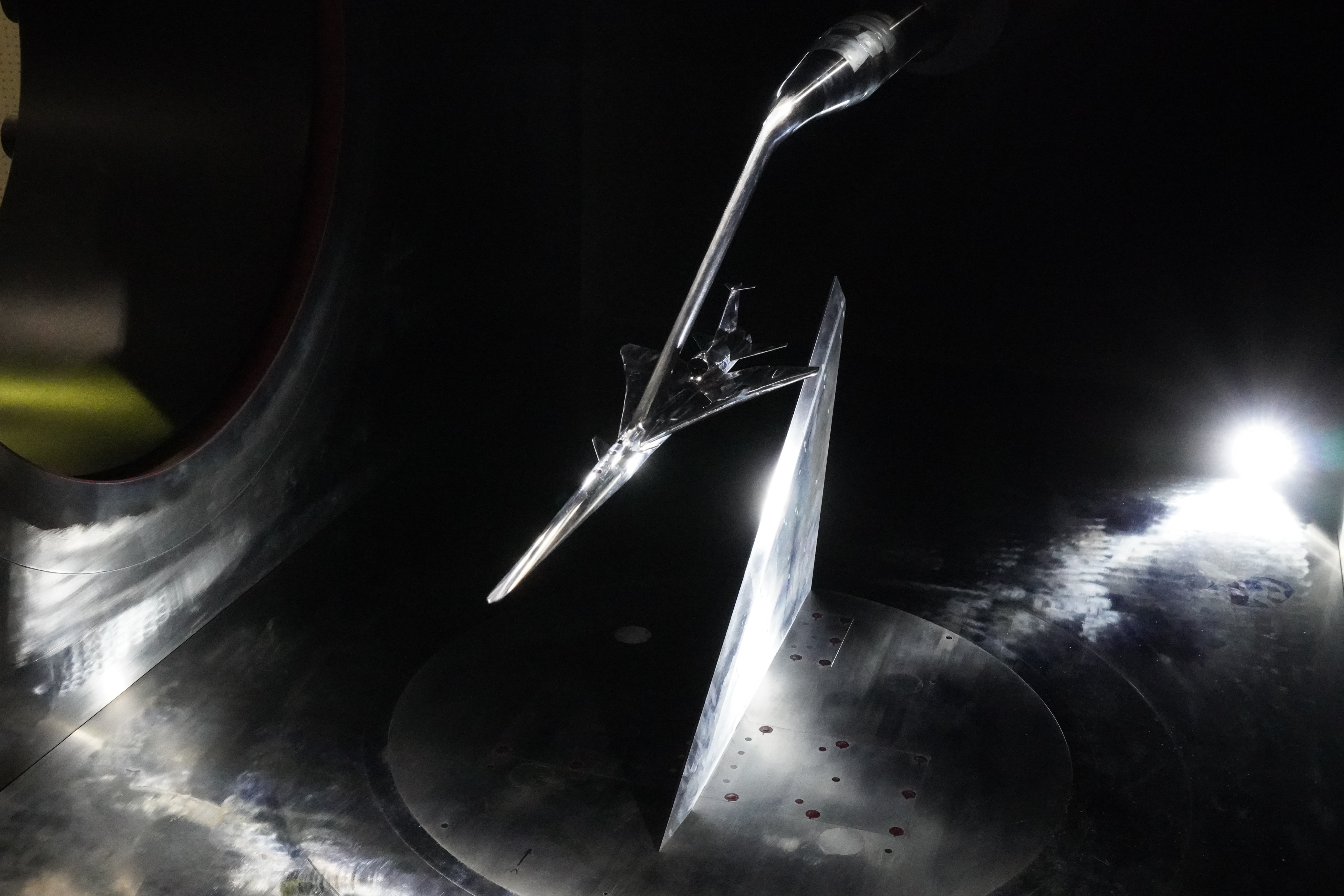
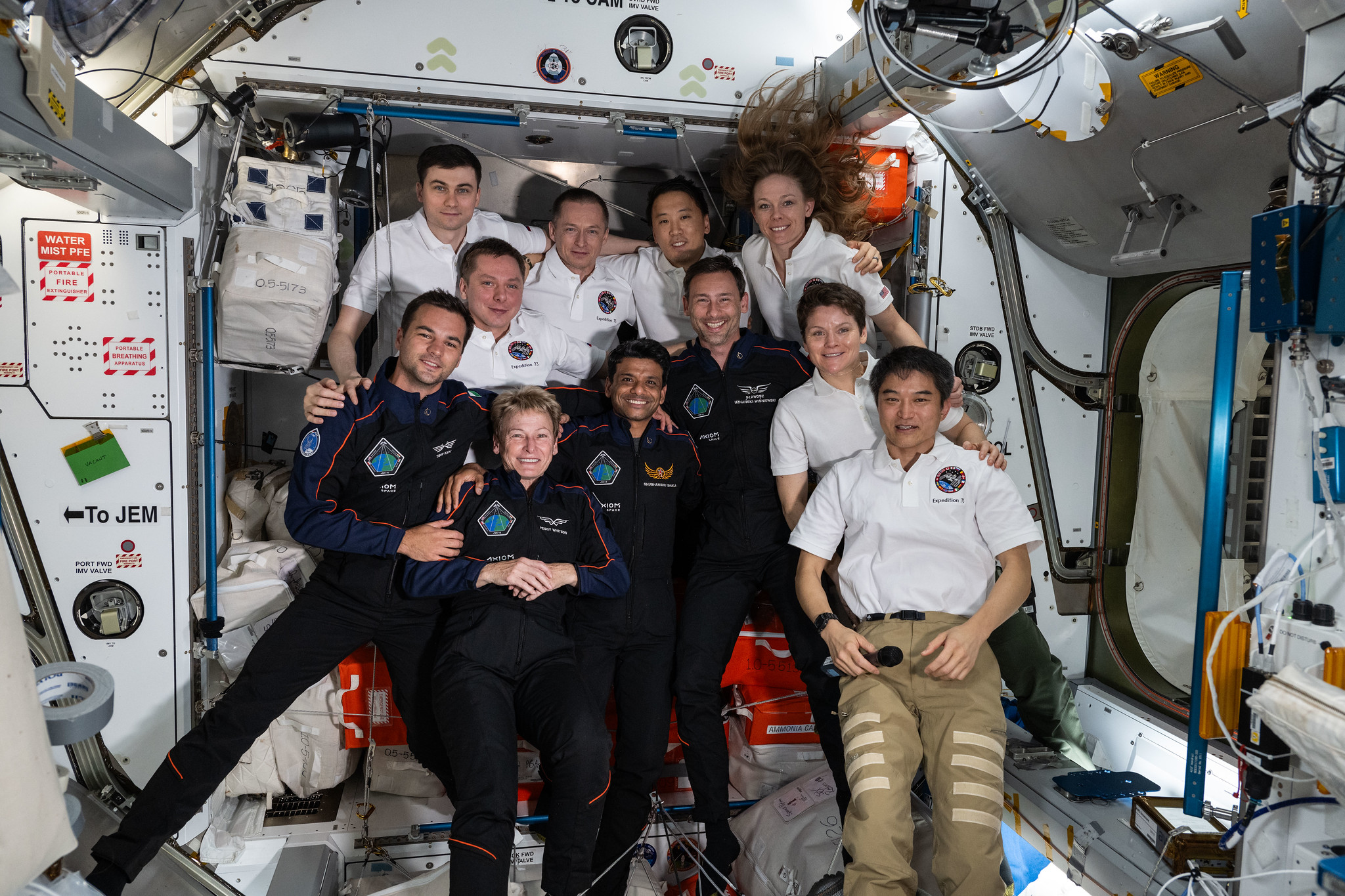
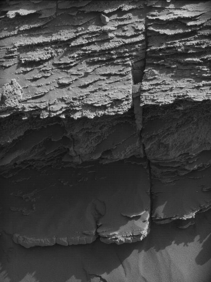
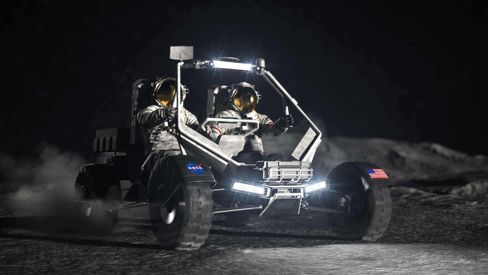
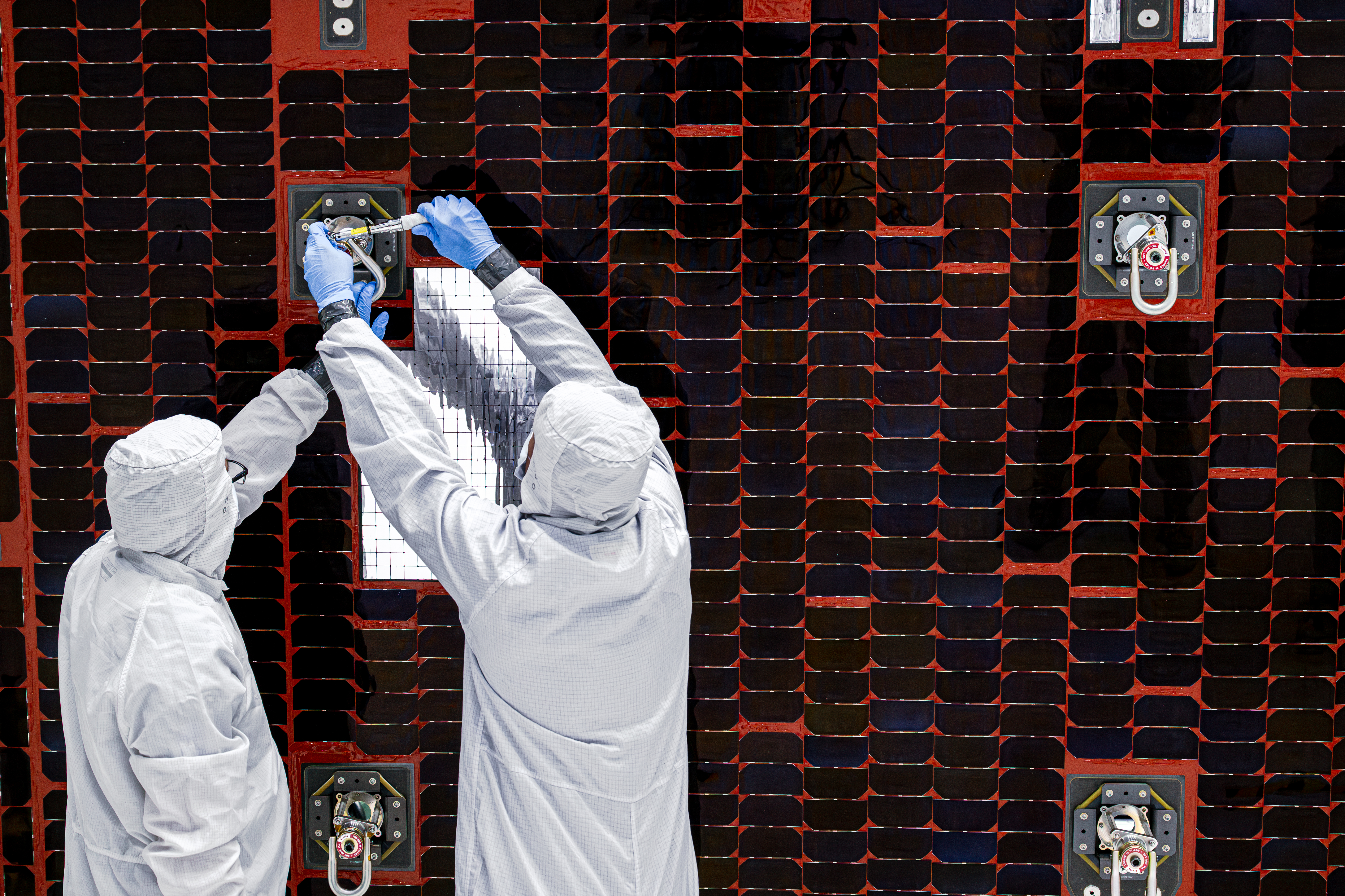