
NASA News
NASA-Assisted Scientists Get Bird’s-Eye View of Population Status
- Earth
- Explore
- Science at Work
- Multimedia
- Data
- For Researchers
- About Us
4 min read
NASA-Assisted Scientists Get Bird’s-Eye View of Population StatusThrough the eBird citizen scientist program, millions of birders have recorded their observations of different species and submitted checklists to the Cornell Lab of Ornithology. Through a partnership with NASA, the lab has now used this data to model and map bird population trends for nearly 500 North American species.
Led by Alison Johnston of the University of St. Andrews in Scotland, the researchers reported that 75% of bird species in the study are declining at wide-range scales. And yet this study has some good news for birds. The results, published in Science in May, offer insights and projections that could shape the future conservation of the places where birds make their homes.
“This project demonstrates the power of merging in situ data with NASA remote sensing to model biological phenomena that were previously impossible to document,” said Keith Gaddis, NASA’s Biological Diversity and Ecological Forecasting program manager at the agency’s headquarters in Washington, who was not involved in the study. “This data provides not just insight into the Earth system but also provides actionable guidance to land managers to mitigate biodiversity loss.”
Rock wren in Joshua Tree National Park. National Park Service / Jane GambleA team from Cornell, the University of St. Andrews, and the American Bird Conservancy used land imaging data from NASA’s Moderate Resolution Imaging Spectroradiometer (MODIS) instruments to distinguish among such specific bird habitats as open forests, dense shrublands, herbaceous croplands, and forest/cropland mosaics. They also drew on NASA weather information and water data that matched the dates and times when birders made their reports.
When combined with a 14-year set of eBird checklists — 36 million sets of species observations and counts, keyed directly to habitats — the satellite data gave researchers almost a strong foundation to produce a clear picture of the health of bird populations. But there was one missing piece.
Wrestling with Wren DataWhile some eBird checklists come from expert birders who’ve hiked deep into wildlife preserves, others are sent in by novices watching bird feeders and doing the dishes. This creates what Cornell statistician Daniel Fink described as “an unstructured, very noisy data set,” complete with gaps in the landscape that birders did not reach and, ultimately, some missing birds.
To account for gaps where birds weren’t counted, the researchers trained machine learning models to fill in the maps based on the remote sensing data. “For every single species — say the rock wren — we’ve created a simulation that mimics the species and a variety of ways that it could respond to changes in the environment,” Johnston said. “Thousands of simulations underlie the results we showed.”
CornellLab eBirdThe researchers achieved unprecedented resolution, zeroing in on areas 12 miles by 12 miles (27 km by 27 km), the same area as Portland, Oregon. This new population counting method can also be applied to eBird data from other locations, Fink said. “Now we’re using modeling to track bird populations — not seasonally through the year, but acrossthe years — a major milestone,” he added.
“We’ve been able to take citizen science data and, through machine learning methodology, put it on the same footing as traditionally structured surveys, in terms of the type of signal we can find,” said Cornell science product manager Tom Auer. “It will increase the credibility and confidence of people who use this information for precise conservation all over the globe.”
The Up SideSince 1970, North America has lost one-quarter of its breeding birds, following a global trend of declines across species. The causes range from increased pollution and land development to changing climate and decreased food resources. Efforts to reverse this loss depend on identifying the areas where birds live at highest risk, assessing their populations, and pinpointing locations where conservation could help most.
For 83% of the reported species in the new study, the decline was greatest in spots where populations had previously been most abundant — indicating problems with the habitat.
“Even in species where populations are declining a lot, there are still places of hope, where the populations are going up,” Johnston said. The team found population increases in the maps of 97% of the reported species. “That demonstrates that there’s opportunity for those species.”
“Birds face so many challenges,” said Cornell conservationist Amanda Rodewald. “This research will help us make strategic decisions about making changes that are precise, effective, and less costly. This is transformative. Now we can really drill in and know where specifically we’re going to be able to have the most positive impact in trying to stem bird declines.”
NASA Headquarters, Washington
Share Details Last Updated Jun 25, 2025 Related Terms Explore More 3 min read NASA Scientists Find Ties Between Earth’s Oxygen and Magnetic FieldArticle
1 week ago
1 min read From Space to Soil: How NASA Sees Forests
NASA uses satellite lidar technology to study Earth’s forests, key carbon sinks.
Article
1 week ago
12 min read NASA’s Hurricane Science, Tech, Data Help American Communities
With hurricane season underway, NASA is gearing up to produce cutting-edge research to bolster the…
Article
2 weeks ago
Keep Exploring Discover More Topics From NASA Earth
Your home. Our Mission. And the one planet that NASA studies more than any other.
Explore Earth Science
Earth Science in Action
NASA’s unique vantage point helps us inform solutions to enhance decision-making, improve livelihoods, and protect our planet.
Earth Multimedia & Galleries
What Are Asteroids? (Ages 14-18)
Asteroids are rocky objects that orbit the Sun just like planets do. In fact, sometimes asteroids are called “minor planets.” These space rocks were left behind after our solar system formed about 4.6 billion years ago.
Asteroids are found in a wide range of sizes. For example, one small asteroid, 2015 TC25, has a diameter of about 6 feet – about the size of a small car – while the asteroid Vesta is nearly 330 miles in diameter, almost as wide as the U.S. state of Arizona. Some asteroids even have enough gravity to have one or two small moons of their own.
There are more than a million known asteroids. Many asteroids are given names. An organization called the International Astronomical Union is responsible for assigning names to objects like asteroids and comets.
This illustration depicts NASA’s Psyche spacecraft as it approaches the asteroid Psyche. Once it arrives in 2029, the spacecraft will orbit the metal-rich asteroid for 26 months while it conducts its science investigation.NASA/JPL-Caltech/ASU What’s the difference between asteroids, meteors, and comets?Although all of these celestial bodies orbit the Sun, they are not the same. Unlike asteroids, which are rocky, comets are a mix of dust and ice. Meteors are small space rocks that get pulled close enough to enter Earth’s atmosphere, where they either burn up as a shooting star or land on the ground as a meteorite.
What are asteroids made of?Different types of asteroids are composed of different mixes of materials. Most of them are made of chondrites, which are combinations of materials such as rocks and clay. These are called “C-type” asteroids. Some, called “S-type,” are made of stony materials, while “M-type” asteroids are composed of metallic elements.
NASA’s Dawn spacecraft captured this image of Vesta as it left the giant asteroid’s orbit in 2012. The framing camera was looking down at the north pole, which is in the middle of the image.NASA/JPL-Caltech/UCLA/MPS/DLR/IDA How did the asteroids form?Asteroids formed around the same time and in the same way as the planets in our solar system. A massive, dense cloud of gas and dust collapsed into a spinning disk, and the gravity in the disk’s center pulled more and more material toward it. Over time, these pieces repeatedly collided with each other, sometimes resulting in smaller fragments and other times clumping together, resulting in much bigger objects.
Objects with a lot of mass – like planets – produced enough gravity to pull themselves into spheres, but many smaller objects didn’t. These ended up becoming comets, small moons, and, yes, asteroids. Although some asteroids have a spherical shape, most have irregular shapes – sometimes oblong, bumpy, or jagged.
The main asteroid belt lies between Mars and Jupiter, and Trojan asteroids both lead and follow Jupiter. Scientists now know that asteroids were the original “building blocks” of the inner planets. Those that remain are airless rocks that failed to adhere to one another to become larger bodies as the solar system was forming 4.6 billion years ago.Credits: NASA, ESA and J. Olmsted (STScI) Where are asteroids found?Most of the asteroids we know about are located in an area called the main asteroid belt, which is found in the space between Mars and Jupiter. But asteroids are found in other parts of the solar system, too.
Trojan asteroids orbit the Sun on the same orbital path as a planet. They’re found at two specific points on the planetary orbit called Lagrange points. At these points, the gravitational pull of the planet and the Sun are in balance, making these points gravity-neutral and stable. Many planets have been found to have Trojan asteroids, including Earth.
An asteroid’s location can also be influenced by the gravity of planets it passes and end up pushed or pulled onto a path that brings it close to Earth. When asteroids or comets are on an orbital path that comes within 30 million miles of Earth’s orbit, we call them near-Earth objects.
Illustration of NASA’s DART spacecraft and the Italian Space Agency’s (ASI) LICIACube, with images of the asteroids Dimorphos and Didymos obtained by the DART spacecraft.Credit: NASA/Johns Hopkins APL/Joshua Diaz Could an asteroid come close enough to hit Earth?Yes! Throughout history, asteroids or pieces of asteroids have collided with Earth, our Moon, and the other planets, too. The effects of some of these impacts are still visible. For example, Chicxulub Crater was created 65 million years ago when a massive asteroid struck Mexico’s Yucatan Peninsula. The resulting cloud of dust and gas released into Earth’s atmosphere blocked sunlight, leading to a mass extinction that included the dinosaurs. More recently, in 2013, people in Chelyabinsk, Russia, witnessed an asteroid almost as wide as a tennis court explode in the atmosphere above them. That event produced a powerful shockwave that caused injuries and damaged structures.
This is why NASA’s Planetary Defense Coordination Office keeps a watchful eye on near-Earth objects. The Planetary Defense team relies on telescopes and observatories on Earth and in space to detect and monitor objects like these that could stray too close to our planet.
The agency is working on planetary defense strategies to use if an asteroid is discovered to be heading our way. For example, NASA’s DART (Double Asteroid Redirection Test) mission in 2022 was a first-of-its-kind test: an uncrewed spacecraft with an autonomous targeting system intentionally flew into the asteroid Dimorphos, successfully changing its orbit.
Jason Dworkin, OSIRIS-REx mission project scientist, holds up a vial containing part of the sample from asteroid Bennu in 2023.Credit: NASA/James Tralie How does NASA study asteroids?NASA detects and tracks asteroids using telescopes on the ground and in space, radar observations, and computer modeling. The agency also has launched several robotic explorers to learn more about asteroids. Some missions study asteroids from above, such as the Psyche mission, launched in 2023 to study the asteroid Psyche beginning in 2029. Other missions have actually made physical contact with asteroids. For example, the DART mission mentioned above impacted an asteroid to change its orbit, and the OSIRIS-REx (Origins, Spectral Interpretation, Resource Identification and Security – Regolith Explorer) spacecraft collected a sample of material from the surface of asteroid Bennu and delivered the sample to Earth in 2023 for scientists to study.
Career CornerWant a career where you get to study asteroids? Here are some jobs at NASA that do just that:
- Astronomer: These scientists observe and study planets, stars, and galaxies. Astronomers make discoveries that help us understand how the universe works and how it is changing. This job requires a strong educational background in science, math, and computer science.
- Geologist: Asteroids are made of different types of rock, clay, or metallic materials. Geologists study the properties and composition of these materials to learn about the processes that have shaped Earth and other celestial bodies, like planets, moons, and asteroids.
Asteroid Facts
Gallery: What’s That Space Rock?
Center for Near Earth Object Studies
Planetary Defense at NASA
Asteroid Watch: Keeping an Eye on Near-Earth Objects
John Casani, Former Manager of Multiple NASA Missions, Dies
6 min read
Preparations for Next Moonwalk Simulations Underway (and Underwater) With Voyager 2 in the background, John Casani holds a small U.S. flag that was sewn into the spacecraft’s thermal blankets before its 1977 launch. Then Voyager’s project manager, Casani was first to envision the mission’s Golden Record, which lies before him with its cover at right. NASA/JPL-CaltechDuring his work on several historic missions, Casani rose through a series of technical and management positions, making an indelible mark on the nation’s space program.
John R. Casani, a visionary engineer who served a central role in many of NASA’s historic deep space missions, died on Thursday, June 19, 2025, at the age of 92. He was preceded in death by his wife of 39 years, Lynn Casani, in 2008 and is survived by five sons and their families.
Casani started at the Jet Propulsion Laboratory in Southern California in 1956 and went on to work as an electronics engineer on some of the nation’s earliest spacecraft after NASA’s formation in 1958. Along with leading the design teams for both the Ranger and Mariner series of spacecraft, he held senior project positions on many of the Mariner missions to Mars and Venus, and was project manager for three trailblazing space missions: Voyager, Galileo, and Cassini.
His work helped advance NASA spacecraft in areas including mechanical technology, system design and integration, software, and deep space communications. No less demanding were the management challenges of these multifaceted missions, which led to innovations still in use today.
JPL’s John Casani receives the National Air & Space Museum’s Lifetime Achievement Award.Carolyn Russo/NASM, National Air and Space Museum, Smithsonian Institution“John had a major influence on the development of spacecraft that visited almost every planet in our solar system, as well as the people who helped build them,” said JPL director Dave Gallagher. “He played an essential role in America’s first attempts to reach space and then the Moon, and he was just as crucial to the Voyager spacecraft that marked humanity’s first foray into interplanetary — and later, interstellar — space. That Voyager is still exploring after nearly 50 years is a testament to John’s remarkable engineering talent and his leadership that enabled others to push the boundaries of possibility.”
Born in Philadelphia in 1932, Casani studied electrical engineering at the University of Pennsylvania. After a short stint at an Air Force research lab, he moved to California in 1956 and was hired to work at JPL, a division of Caltech, on the guidance system for the U.S. Army Ballistic Missile Agency’s Jupiter-C and Sergeant missile programs.
In 1957, the Soviet Union launched Sputnik 1, the first human-made Earth satellite, alarming America and changing the trajectory of both JPL and Casani’s career. With the 1958 launch of Explorer 1, America’s first satellite, the lab transitioned to concentrating on robotic space explorers, and Casani segued from missiles to spacecraft.
One of his jobs as payload engineer on Pioneer 3 and 4, NASA’s first missions to the Moon, was to carry each of the 20-inch-long (51-cm-long) probes in a suitcase from JPL to the launch site at Cape Canaveral, Florida, where he installed them in the rocket’s nose cone.
At the dawn of the 1960s, Casani served as spacecraft systems engineer for the agency’s first two Ranger missions to the Moon, then joined the Mariner project in 1965, earning a reputation for being meticulous. Four years later, he was Mariner project manager.
Asked to share some of his wisdom in a 2009 NASA presentation, Casani said, “The thing that makes any of this work … is toughness. Toughness because this is a tough business, and it’s a very unforgiving business. You can do 1,000 things right, but if you don’t do everything right, it’ll come back and bite you.”
Casani’s next role: project manager for NASA’s high-profile flagship mission to the outer planets and beyond — Voyager. He not only led the mission from clean room to space, he was first to envision attaching a message representing humanity to any alien civilization that might encounter humanity’s first interstellar emissaries.
“I approached Carl Sagan,” he said in a 2007 radio interview, “and asked him if he could come up with something that would be appropriate that we could put on our spacecraft in a way of sending a message to whoever might receive it.” Sagan took up the challenge, and what resulted was the Golden Record, a 12-inch gold-plated copper disk containing sounds and images selected to portray the diversity of life and culture on Earth.
Once Voyager 1 and 2 and their Golden Records launched in 1977, JPL wasted no time in pointing their “engineer’s engineer” toward Galileo, which would become the first mission to orbit a gas giant planet. As the mission’s initial project manager, Casani led the effort from inception to assembly. Along the way, he had to navigate several congressional attempts to end the project, necessitating multiple visits to Washington. The 1986 loss of Space Shuttle Challenger, from which Galileo was to launch atop a Centaur upper-stage booster, led to mission redesign efforts before its 1989 launch.
After 11 years leading Galileo, Casani became deputy assistant laboratory director for flight projects in 1988, received a promotion just over a year later and then, from 1990 to 1991, served as project manager of Cassini, NASA’s first flagship mission to orbit Saturn.
Casani became JPL’s first chief engineer in 1994, retiring in 1999 and serving on several nationally prominent committees, including leading the investigation boards of both the Mars Climate Orbiter and the Mars Polar Lander failures, and also leading the James Webb Space Telescope Independent Comprehensive Review Panel.
In early 2003, Casani returned to JPL to serve as project manager for NASA’s Project Prometheus, which would have been the nation’s first nuclear-powered, electric-propulsion spacecraft. In 2005, he became manager of the Institutional Special Projects Office at JPL, a position he held until retiring again in 2012.
“Throughout his career, John reflected the true spirit of JPL: bold, innovative, visionary, and welcoming,” said Charles Elachi, JPL’s director from 2001 to 2016. “He was an undisputed leader with an upbeat, fun attitude and left an indelible mark on the laboratory and NASA. I am proud to have called him a friend.”
Casani received many awards over his lifetime, including NASA’s Exceptional Achievement Medal, the Management Improvement Award from the President of the United States for the Mariner Venus Mercury mission, and the Air and Space Museum Trophy for Lifetime Achievement.
News Media ContactsMatthew Segal / Veronica McGregor
Jet Propulsion Laboratory, Pasadena, Calif.
818-354-8307 / 818-354-9452
matthew.j.segal@jpl.nasa.gov / veronica.c.mcgregor@jpl.nasa.gov
Missions
Humans in Space
Climate Change
Solar System
Meet Rob Navias: Public Affairs Officer and Mission Commentator
Editor’s note: This interview was conducted in October 2023.
As the International Space Station approaches 25 years of continuous human presence on Nov. 2, 2025, it is a meaningful moment to recognize those who have been there since the beginning—sharing the remarkable achievements of human spaceflight with the world.
If you have ever witnessed the live coverage of a NASA spacewalk or launch, then you know the captivating voice of celestial storyteller Rob Navias. Navias effortlessly blends expertise, enthusiasm, and profound insight into every mission.
Rob Navias on console in the Mission Control Center covering an Extravehicular Activity aboard the International Space Station. NASA/Bill Stafford I relay the facts and data with history in mind. You need to maintain a sense of history if you're going to be able to tell the contemporary story properly.Rob Navias
Public Affairs Officer and Mission Commentator
Navias works within the Office of Public Affairs on mission operations and television in NASA Johnson Space Center’s Office of Communications, leading public affairs activities involving launches and landings of U.S. astronauts and international partner crew members. He is iconically known as the voice of NASA.
He has been a part of some of the most impactful moments in space exploration history, communicating the facts in real time with unmatched clarity. He covered every shuttle mission from the maiden launch of Columbia in April 1981 to Atlantis’ final voyage in July 2011. Navias is known for connecting others accurately and honestly to key moments in time.
Navias’ extraordinary contributions to space communications garnered him the 2017 Space Communicator Award from the Rotary National Award for Space Achievement Foundation. This prestigious accolade is presented to individuals or teams who have made remarkable contributions to public understanding and appreciation of space exploration. Navias’ unwavering dedication to NASA was recognized with the 2023 Length of Federal Service Award, commemorating his 30-year commitment to the agency.
His legacy continued on screen in Cosmic Dawn, the NASA documentary exploring the James Webb Space Telescope’s incredible journey. Featured for his role as the launch commentator during Webb’s Christmas Day 2021 liftoff, Navias brought historical context and lived experience to one of NASA’s most ambitious missions.
As long as we can maintain a shared vision and curiosity, all nations can go a long way up to the universe.Rob Navias
Public Affairs Officer and Mission Commentator
He began his broadcast career as a correspondent for networks covering the Space Shuttle Program. Before joining NASA in 1993, Navias had a 25-year career in broadcast journalism where he reported the voyage of Pioneer 11, a robotic space probe that studied the asteroid belt and the rings of Saturn, as well as the test flights for the Space Shuttle Enterprise at Edwards Air Force Base in California and the Voyager missions from NASA’s Jet Propulsion Laboratory in Southern California.
Navias also covered the Apollo-Soyuz Test Project as a broadcast journalist. That first international human spaceflight showed the world there was a way for nations to work together peacefully for a common goal, Navias stated.
“Once the commitment was made to fund the construction of an international space station, it broadened the agency’s scope to work multiple programs that could be a stepping stone beyond low Earth orbit,” Navias said.
Rob Navias (left), accompanied by Phil Engelauf and John Shannon, during an STS-114 Flight Director press briefing.NASA I think the greatest legacy of the International Space Station will ultimately be the diplomatic oasis it has provided in orbit for exploration and scientific research.ROB Navias
Public Affairs Officer and Mission Commentator
Navias explained that during his time at NASA, he has learned a lot about himself. “The day you stop absorbing information, the day that you grow tired of learning new things is the day you need to walk away,” he said. “The challenge of spaceflight keeps me here at NASA.”
Navias underscored the importance of nurturing and retaining the agency’s brilliant workforce who have shaped the pioneering mindset of human space exploration. He believes blending talent, resources, and industry expertise is the key to returning to the Moon and going to Mars. This collaborative mindset has not only resulted in establishing a laboratory in low Earth orbit but also paved the way for future missions.
Explore More 5 min read Driven by a Dream: Farah Al Fulfulee’s Quest to Reach the Stars Article 1 week ago 5 min read Heather Cowardin Safeguards the Future of Space Exploration Article 2 days ago 5 min read Nilufar Ramji: Shaping Johnson’s Giant Leaps Forward Article 2 months agoNASA’s Perseverance Rover Scours Mars for Science
6 min read
Preparations for Next Moonwalk Simulations Underway (and Underwater)In addition to drilling rock core samples, the science team has been grinding its way into rocks to make sense of the scientific evidence hiding just below the surface.
NASA’s Perseverance rover uses an abrading bit to get below the surface of a rocky out-crop nicknamed “Kenmore” on June 10. The eight images that make up this video were taken approximately one minute apart by one of the rover’s front hazard-avoidance cameras. NASA/JPL-CaltechOn June 3, NASA’s Perseverance Mars rover ground down a portion of a rock surface, blew away the resulting debris, and then went to work studying its pristine interior with a suite of instruments designed to determine its mineralogic makeup and geologic origin. “Kenmore,” as nicknamed by the rover science team, is the 30th Martian rock that Perseverance has subjected to such in-depth scrutiny, beginning with drilling a two-inch-wide (5-centimeter-wide) abrasion patch.
“Kenmore was a weird, uncooperative rock,” said Perseverance’s deputy project scientist, Ken Farley from Caltech in Pasadena, California. “Visually, it looked fine — the sort of rock we could get a good abrasion on and perhaps, if the science was right, perform a sample collection. But during abrasion, it vibrated all over the place and small chunks broke off. Fortunately, we managed to get just far enough below the surface to move forward with an analysis.”
The science team wants to get below the weathered, dusty surface of Mars rocks to see important details about a rock’s composition and history. Grinding away an abrasion patch also creates a flat surface that enables Perseverance’s science instruments to get up close and personal with the rock.
This close-up view of an abrasion showing distinctive “tool marks” created by the Perseverance’s abrading bit was acquired on June 5. The image was taken from approximately 2.76 inches (7 centimeters) away by the rover’s WATSON imager. NASA/JPL-Caltech/MSSS Perseverance’s gold-colored abrading bit takes center stage in this image of the rover’s drill taken by the Mastcam-Z instrument on Aug. 2, 2021, the 160th day of the mission to Mars.NASA/JPL-Caltech/ASU/MSSS Time to GrindNASA’s Mars Exploration Rovers, Spirit and Opportunity, each carried a diamond-dust-tipped grinder called the Rock Abrasion Tool (RAT) that spun at 3,000 revolutions per minute as the rover’s robotic arm pushed it deeper into the rock. Two wire brushes then swept the resulting debris, or tailings, out of the way. The agency’s Curiosity rover carries a Dust Removal Tool, whose wire bristles sweep dust from the rock’s surface before the rover drills into the rock. Perseverance, meanwhile, relies on a purpose-built abrading bit, and it clears the tailings with a device that surpasses wire brushes: the gaseous Dust Removal Tool, or gDRT.
“We use Perseverance’s gDRT to fire a 12-pounds-per-square-inch (about 83 kilopascals) puff of nitrogen at the tailings and dust that cover a freshly abraded rock,” said Kyle Kaplan, a robotic engineer at NASA’s Jet Propulsion Laboratory in Southern California. “Five puffs per abrasion — one to vent the tanks and four to clear the abrasion. And gDRT has a long way to go. Since landing at Jezero Crater over four years ago, we’ve puffed 169 times. There are roughly 800 puffs remaining in the tank.” The gDRT offers a key advantage over a brushing approach: It avoids any terrestrial contaminants that might be on a brush from getting on the Martian rock being studied.
To view this video please enable JavaScript, and consider upgrading to a web browser that supports HTML5 video
This video captures a test of Perseverance’s Gaseous Dust Removal Tool (gDRT) in a vacuum chamber at NASA’s Jet Propulsion Laboratory in August 2020. The tool fires puffs of nitrogen gas at the tailings and dust that cover a rock after it has been abraded by the rover.NASA/JPL-CaltechHaving collected data on abraded surfaces more than 30 times, the rover team has in-situ science (studying something in its original place or position) collection pretty much down. After gDRT blows the tailings away, the rover’s WATSON (Wide Angle Topographic Sensor for Operations and eNgineering) imager (which, like gDRT, is at the end of the rover’s arm) swoops in for close-up photos. Then, from its vantage point high on the rover’s mast, SuperCam fires thousands of individual pulses from its laser, each time using a spectrometer to determine the makeup of the plume of microscopic material liberated after every zap. SuperCam also employs a different spectrometer to analyze the visible and infrared light that bounces off the materials in the abraded area.
“SuperCam made observations in the abrasion patch and of the powdered tailings next to the patch,” said SuperCam team member and “Crater Rim” campaign science lead, Cathy Quantin-Nataf of the University of Lyon in France. “The tailings showed us that this rock contains clay minerals, which contain water as hydroxide molecules bound with iron and magnesium — relatively typical of ancient Mars clay minerals. The abrasion spectra gave us the chemical composition of the rock, showing enhancements in iron and magnesium.”
Later, the SHERLOC (Scanning Habitable Environments with Raman & Luminescence for Organics & Chemicals) and PIXL (Planetary Instrument for X-ray Lithochemistry) instruments took a crack at Kenmore, too. Along with supporting SuperCam’s discoveries that the rock contained clay, they detected feldspar (the mineral that makes much of the Moon brilliantly bright in sunlight). The PIXL instrument also detected a manganese hydroxide mineral in the abrasion — the first time this type of material has been identified during the mission.
With Kenmore data collection complete, the rover headed off to new territories to explore rocks — both cooperative and uncooperative — along the rim of Jezero Crater.
“One thing you learn early working on Mars rover missions is that not all Mars rocks are created equal,” said Farley. “The data we obtain now from rocks like Kenmore will help future missions so they don’t have to think about weird, uncooperative rocks. Instead, they’ll have a much better idea whether you can easily drive over it, sample it, separate the hydrogen and oxygen contained inside for fuel, or if it would be suitable to use as construction material for a habitat.”
Long-Haul RovingOn June 19 (the 1,540th Martian day, or sol, of the mission), Perseverance bested its previous record for distance traveled in a single autonomous drive, trekking 1,348 feet (411 meters). That’s about 210 feet (64 meters) more than its previous record, set on April 3, 2023 (Sol 753). While planners map out the rover’s general routes, Perseverance can cut down driving time between areas of scientific interest by using its self-driving system, AutoNav.
“Perseverance drove 4½ football fields and could have gone even farther, but that was where the science team wanted us to stop,” said Camden Miller, a rover driver for Perseverance at JPL. “And we absolutely nailed our stop target location. Every day operating on Mars, we learn more on how to get the most out of our rover. And what we learn today future Mars missions won’t have to learn tomorrow.”
News Media ContactDC Agle
Jet Propulsion Laboratory, Pasadena, Calif.
818-393-9011
agle@jpl.nasa.gov
Karen Fox / Molly Wasser
NASA Headquarters, Washington
202-358-1600
karen.c.fox@nasa.gov / molly.l.wasser@nasa.gov
2025-082
Share Details Last Updated Jun 25, 2025 Related Terms Explore More 6 min read John Casani, Former Manager of Multiple NASA Missions, Dies Article 2 hours ago 5 min read NASA’s Curiosity Mars Rover Starts Unpacking Boxwork Formations Article 2 days ago 4 min read NASA Mars Orbiter Captures Volcano Peeking Above Morning Cloud Tops Article 3 weeks ago Keep Exploring Discover Related TopicsMissions
Humans in Space
Climate Change
Solar System
NASA to Welcome Fourth Private Astronaut Mission to Space Station
As part of NASA’s efforts to expand access to space, four private astronauts are in orbit following the successful launch of the fourth all private astronaut mission to the International Space Station.
A SpaceX Dragon spacecraft lifted off at 2:31 a.m. EDT Wednesday from Launch Complex 39A at NASA’s Kennedy Space Center in Florida, carrying Axiom Mission 4 crew members Peggy Whitson, former NASA astronaut and director of human spaceflight at Axiom Space as commander, ISRO (Indian Space Research Organisation) astronaut and pilot Shubhanshu Shukla, and mission specialists ESA (European Space Agency) project astronaut Sławosz Uznański-Wiśniewski of Poland and HUNOR (Hungarian to Orbit) astronaut Tibor Kapu of Hungary.
“Congratulations to Axiom Space and SpaceX on a successful launch,” said NASA acting Administrator Janet Petro. “Under President Donald Trump’s leadership, America has expanded international participation and commercial capabilities in low Earth orbit. U.S. industry is enabling astronauts from India, Poland, and Hungary to return to space for the first time in over forty years. It’s a powerful example of American leadership bringing nations together in pursuit of science, discovery, and opportunity.”
A collaboration between NASA and ISRO allowed Axiom Mission 4 to deliver on a commitment highlighted by President Trump and Indian Prime Minister Narendra Modi to send the first ISRO astronaut to the station. The space agencies are participating in five joint science investigations and two in-orbit science, technology, engineering, and mathematics demonstrations. NASA and ISRO have a long-standing relationship built on a shared vision to advance scientific knowledge and expand space collaboration.
This mission serves as an example of the success derived from collaboration between NASA’s international partners and American commercial space companies.
Live coverage of the spacecraft’s arrival will begin at 5 a.m., Thursday, June 26, on NASA+. Learn how to watch NASA content through a variety of platforms, including social media.
The spacecraft is scheduled to autonomously dock at approximately 7 a.m. to the space-facing port of the space station’s Harmony module.
Once aboard the station, Expedition 73 crew members, including NASA astronauts, Nicole Ayers, Anne McClain, and Jonny Kim, JAXA (Japan Aerospace Exploration Agency) astronaut Takuya Onishi, and Roscosmos cosmonauts Kirill Peskov, Sergey Ryzhikov, and Alexey Zubritsky will welcome the astronauts.
The crew is scheduled to remain at the space station, conducting microgravity research, educational outreach, and commercial activities for about two weeks before a return to Earth and splashdown off the coast of California.
The International Space Station is a springboard for developing a low Earth economy. NASA’s goal is to achieve a strong economy off the Earth where the agency can purchase services as one of many customers to meet its science and research objectives in microgravity. NASA’s commercial strategy for low Earth orbit provides the government with reliable and safe services at a lower cost, empowers U.S. industry, and enables the agency to focus on Artemis missions to the Moon in preparation for Mars while also continuing to use low Earth orbit as a training and proving ground for those deep space missions.
Learn more about NASA’s commercial space strategy at:
https://www.nasa.gov/commercial-space
-end-
Josh Finch
Headquarters, Washington
202-358-1100
joshua.a.finch@nasa.gov
Anna Schneider
Johnson Space Center, Houston
281-483-5111
anna.c.schneider@nasa.gov
NASA Sets Coverage for Axiom Mission 4 Launch, Arrival at Station
NASA, Axiom Space, and SpaceX are targeting 2:31 a.m. EDT, Wednesday, June 25, for launch of the fourth private astronaut mission to the International Space Station, Axiom Mission 4.
The mission will lift off from Launch Complex 39A at NASA’s Kennedy Space Center in Florida. The crew will travel to the orbiting laboratory on a new SpaceX Dragon spacecraft after launching on the company’s Falcon 9 rocket. The targeted docking time is approximately 7 a.m. Thursday, June 26.
This launch opportunity comes after NASA and Roscosmos officials discussed the status of the recent repair work in the transfer tunnel at the aft (back) most segment of the orbital laboratory’s Zvezda service module. Based on the evaluations, NASA and Roscosmos agreed to further lower the pressure in the transfer tunnel to 100 millimeters of mercury, and teams will continue to evaluate going forward. Safety remains a top priority for NASA and Roscosmos.
“NASA and Roscosmos have a long history of cooperation and collaboration on the International Space Station. This professional working relationship has allowed the agencies to arrive at a shared technical approach and now Axiom Mission 4 launch and docking will proceed,” said acting NASA Administrator Janet Petro. “We look forward to the launch with Axiom Space and SpaceX for this commercial international mission.”
For this mission, NASA is responsible for integrated operations, which begins during the spacecraft’s approach to the space station, continues during the crew’s stay aboard the orbiting laboratory conducting science, education, and commercial activities, and concludes once the spacecraft departs the station.
Live coverage of launch and arrival activities will stream on NASA+. Learn how to watch NASA content through a variety of platforms, including social media.
Peggy Whitson, former NASA astronaut and director of human spaceflight at Axiom Space, will command the commercial mission, while ISRO (Indian Space Research Organisation) astronaut Shubhanshu Shukla will serve as pilot. The two mission specialists are ESA (European Space Agency) project astronaut Sławosz Uznański-Wiśniewski of Poland, and HUNOR (Hungarian to Orbit) astronaut Tibor Kapu of Hungary.
Once docked, the private astronauts plan to spend about two weeks aboard the orbiting laboratory, conducting a mission comprised of science, outreach, and commercial activities.
As part of a collaboration between NASA and ISRO, Axiom Mission 4 delivers on a commitment highlighted by President Donald Trump and Indian Prime Minister Narendra Modi to send the first ISRO astronaut to the station. The space agencies are participating in five joint science investigations and two in-orbit STEM (science, technology, engineering, and mathematics) demonstrations. NASA and ISRO have a long-standing relationship built on a shared vision to advance scientific knowledge and expand space collaboration.
The private mission also carries the first astronauts from Poland and Hungary to stay aboard the International Space Station.
NASA’s mission coverage is as follows (all times Eastern and subject to change based on real-time operations):
Wednesday, June 25
12:30 a.m. – Axiom Space and SpaceX launch coverage begins.
1:40 a.m. – NASA joins the launch coverage on NASA+.
2:31 a.m. – Launch
NASA will end coverage following orbital insertion, which is approximately 15 minutes after launch. As it is a commercial launch, NASA will not provide a clean launch feed on its channels.
Thursday, June 26
5 a.m. – Arrival coverage begins on NASA+, Axiom Space, and SpaceX channels.
7 a.m. – Targeted docking to the space-facing port of the station’s Harmony module.
Arrival coverage will continue through hatch opening and welcome remarks.
All times are estimates and could be adjusted based on real-time operations after launch. Follow the space station blog for the most up-to-date operations information.
The International Space Station is a springboard for developing a low Earth economy. NASA’s goal is to achieve a strong economy off the Earth where the agency can purchase services as one of many customers to meet its science and research objectives in microgravity. NASA’s commercial strategy for low Earth orbit provides the government with reliable and safe services at a lower cost, enabling the agency to focus on Artemis missions to the Moon in preparation for Mars while also continuing to use low Earth orbit as a training and proving ground for those deep space missions.
Learn more about NASA’s commercial space strategy at:
https://www.nasa.gov/commercial-space
-end-
Joshua Finch
Headquarters, Washington
202-358-1100
joshua.a.finch@nasa.gov
Anna Schneider
Johnson Space Center, Houston
281-483-5111
anna.c.schneider@nasa.gov
NASA Astronaut Zena Cardman
NASA astronaut Zena Cardman inspects her spacesuit’s wrist mirror in this portrait taken at NASA’s Johnson Space Center in Houston on March 22, 2024. Cardman will launch to the International Space Station as part of NASA’s SpaceX Crew-11 mission. This will be her first spaceflight.
Cardman was selected by NASA as a member of the 2017 “Turtles” Astronaut Class. The Virginia native holds a bachelor’s degree in biology and a master’s degree in marine sciences from the University of North Carolina, Chapel Hill. Her research focused primarily on geobiology and geochemical cycling in subsurface environments, from caves to deep sea sediments. Cardman’s experience includes multiple Antarctic expeditions. Since completing initial training, Cardman has supported real-time station operations and lunar surface exploration planning.
This photo was one of the winners of NASA’s 2024 Photos of the Year.
Live or Fly a Plane in California? Help NASA Measure Ozone Pollution!
Ozone high in the stratosphere protects us from the Sun’s ultraviolet light. But ozone near the ground is a pollutant that harms people and plants. The San Joaquin Valley has some of the most polluted air in the country, and NASA scientists with the new Ozone Where We Live (OWWL) project are working to measure ozone and other pollutants there. They need your help!
Do you live or work in Bakersfield, CA? Sign up to host an ozone sensor! It’s like a big lunch box that you place in your yard, but it’s not packed with tuna and crackers. It’s filled with sensors that measure temperature and humidity and sniff out dangerous gases like methane, carbon monoxide, carbon dioxide, and of course, ozone.
Can you fly a plane? Going to the San Joaquin Valley? Sign up to take an ozone sensor on your next flight! You can help measure ozone levels in layers of the atmosphere that are hard for satellites to investigate. Scientists will combine the data you take with data from NASA’s TEMPO satellite to improve air quality models and measurements within the region. Find out more here or email: Emma.l.yates@nasa.gov
Join the Ozone Where We Live (OWWL) project and help NASA scientists protect the people of the San Joaquin Valley! Credit: Emma Yates Share Details Last Updated Jun 24, 2025 Related Terms Explore More 4 min read c-FIRST Team Sets Sights on Future Fire-observing Satellite ConstellationsArticle
3 weeks ago
2 min read Summer Students Scan the Radio Skies with SunRISE
Article
4 weeks ago
2 min read Space Cloud Watch Needs Your Photos of Night-Shining Clouds
Article
1 month ago
NASA’s SLS Solid Rocket Boosters: What is DM-1?
Demonstration Motor-1 (DM-1) is the first full-scale ground test of the evolved five-segment solid rocket motor of NASA’s SLS (Space Launch System) rocket. The event will take place in Promontory, Utah, and will be used as an opportunity to test several upgrades made from the current solid rocket boosters. Each booster burns six tons of solid propellant every second and together generates almost eight million pounds of thrust.
News Media ContactJonathan Deal
Marshall Space Flight Center, Huntsville, Ala.
256-544-0034
jonathan.e.deal@nasa.gov
Mission Accomplished! Artemis ROADS III National Challenge Competitors Celebrate their Achievements
5 min read
Mission Accomplished! Artemis ROADS III National Challenge Competitors Celebrate their AchievementsThe NASA Science Activation program’s Northwest Earth and Space Sciences Pathways (NESSP) team has successfully concluded the 2024–2025 Artemis ROADS III National Challenge, an educational competition that brought real NASA mission objectives to student teams (and reached more than 1,500 learners) across the country. From December 2024 through May 2025, over 300 teams of upper elementary, middle, and high school students from 22 states participated, applying STEM (Science, Technology, Engineering, and Mathematics) skills in exciting and creative ways.
Participants tackled eight Mission Objectives inspired by NASA’s Artemis missions, which aim to return humans to the Moon. Students explored challenges such as:
- Designing a water purification system for the Moon inspired by local water cycles
- Developing a Moon-based agricultural plan based on experimental results
- Programming a rover to autonomously navigate lunar tunnels
- Engineering and refining a human-rated water bottle rocket capable of safely returning a “chip-stronaut” to Earth
- Envisioning their future careers through creative projects like graphic novels or video interviews
- Exploring NASA’s Artemis program through a new Artemis-themed Lotería game
In-person hub events were hosted by Northern Arizona University, Central Washington University, and Montana State University, where teams from Washington, Montana, and Idaho gathered to present their work, collaborate with peers, and experience life on a college campus. Students also had the chance to connect virtually with NASA scientists and engineers through NESSP’s NASA Expert Talks series.
“Artemis ROADS III is NESSP’s eighth ROADS challenge, and I have to say, I think it’s the best one yet. It’s always inspiring to see so many students across the country engage in a truly meaningful STEM experience. I heard from several students and educators that participating in the challenge completely changed their perspective on science and engineering. I believe that’s because this program is designed to let students experience the joy of discovery and invention—driven by both teamwork and personal creativity—that real scientists and engineers love about their work. We also show students the broad range of STEM expertise NASA relies on to plan and carry out a mission like Artemis. Most importantly, it gives them a chance to feel like they are part of the NASA mission, which can be truly transformative.”
– Dr. Darci Snowden, Director, NESSP
NESSP proudly recognizes the following teams for completing all eight Mission Objectives and the Final Challenge:
- Space Pringles, 3rd-5th Grade, San Antonio, TX
- Space Axolotls, 3rd-5th Grade, Roberts, MT
- TEAM Wild, 6th-8th Grade, Eagle Mountain, UT
- Pessimistic Penguins, 6th-8th Grade, Eagle Mountain, UT
- Dwarf Planets, 6th-8th Grade, Eagle Mountain, UT
- Astronomical Rovers, 6th-8th Grade, Eagle Mountain, UT
- Cosmic Honeybuns, 6th-8th Grade, Eagle Mountain, UT
- Houston we have a Problem, 6th-8th Grade, Eagle Mountain, UT
- FBI Wanted List, 6th-8th Grade, Eagle Mountain, UT
- Lunar Legion, 6th-8th Grade, San Antonio, TX
- Artemis Tax-Free Space Stallions, 6th-8th Grade, Egg Harbor, NJ
- Aquila, 6th-8th Grade, Gooding, ID
- Space Warriors, 6th-8th Grade, Wapato, WA
- Team Cygnus, 6th-8th Grade, Red Lodge, MT
- Maple RocketMen, 6th-8th Grade, Northbrook, IL
- RGB Hawks, 6th-8th Grade, Sagle, ID
- The Blue Moon Bigfoots, 6th-8th Grade, Medford, OR
- W.E.P.Y.C.K., 6th-8th Grade, Roberts, MT
- Lunar Dawgz, 6th-8th Grade, Safford, AZ
- ROSEBUD ROCKETEERS, 6th-8th Grade, Rosebud, MT
- The Cosmic Titans, 6th-8th Grade, Thomson Falls, MT
- The Chunky Space Monkeys, 6th-8th Grade, Naches, WA
- ROSEBUD RED ANGUS, 9th-12th Grade, Rosebud, MT
- Bulky Bisons, 9th-12th Grade, Council Grove, KS
- The Falling Stars, 9th-12th Grade, Thomson Falls, MT
- The Roadkillers, 9th-12th Grade, Thomson Falls, MT
- The Goshawks, 9th-12th Grade, Thomson Falls, MT
- Sequim Cosmic Catalysts, 9th-12th Grade, Sequim, WA
- Spuddie Buddies, 9th-12th Grade, Moses Lake, WA
- Astrocoquí 2, 9th-12th Grade, Mayaguez, PR
- Big Sky Celestials, 9th-12th Grade, Billings, MT
- TRYOUTS, 9th-12th Grade, Columbus, MT
- Cosmonaughts, 9th-12th Grade, Columbus, MT
- TCCS 114, 9th-12th Grade, Tillamook, OR
- Marvin’s Mighty Martians, 9th-12th Grade, Simms, TX
You can see highlights of these teams’ work in the Virtual Recognition Ceremony video on the NESSP YouTube channel. The presentation also features the teams selected to travel to Kennedy Space Center in August of 2025, the ultimate prize for these future space explorers!
In addition to student engagement, the ROADS program provided professional development workshops and NGSS-aligned classroom resources to support K–12 educators. Teachers are invited to explore these materials and register for the next round of workshops, beginning in August 2025: https://nwessp.org/professional-development-registration.
For more information about NESSP, its programs, partners, and the ROADS National Challenge, visit www.nwessp.org or contact info@nwessp.org.
———–
NASA’s Northwest Earth and Space Science Pathways’ (NESSP) project is supported by NASA cooperative agreement award number 80NSSC22M0006 and is part of NASA’s Science Activation Portfolio. Learn more about how Science Activation connects NASA science experts, real content, and experiences with community leaders to do science in ways that activate minds and promote deeper understanding of our world and beyond: https://science.nasa.gov/learn/about-science-activation/
A water bottle rocket launches into the air carrying its precious chip-stronaut cargo. Share Details Last Updated Jun 23, 2025 Editor NASA Science Editorial Team Related Terms Explore More 3 min read NASA Scientists Find Ties Between Earth’s Oxygen and Magnetic FieldArticle
5 days ago
3 min read NASA Interns Conduct Aerospace Research in Microgravity
Article
4 weeks ago
5 min read Percolating Clues: NASA Models New Way to Build Planetary Cores
Article
1 month ago
Keep Exploring Discover More Topics From NASA James Webb Space Telescope
Webb is the premier observatory of the next decade, serving thousands of astronomers worldwide. It studies every phase in the…
Perseverance Rover
This rover and its aerial sidekick were assigned to study the geology of Mars and seek signs of ancient microbial…
Parker Solar Probe
On a mission to “touch the Sun,” NASA’s Parker Solar Probe became the first spacecraft to fly through the corona…
Juno
NASA’s Juno spacecraft entered orbit around Jupiter in 2016, the first explorer to peer below the planet’s dense clouds to…
NASA’s Curiosity Mars Rover Starts Unpacking Boxwork Formations
5 min read
Preparations for Next Moonwalk Simulations Underway (and Underwater) Drag your mouse or move your phone to pan around within this 360-degree view to explore the boxwork patterns on Mars that NASA’s Curiosity is investigating for the first time. The rover captured the 291 images that make up this mosaic between May 15 and May 18.Credit: NASA/JPL-Caltech/MSSS
The rover recently drilled a sample from a new region with features that could reveal whether Mars’ subsurface once provided an environment suitable for life.
New images from NASA’s Curiosity Mars rover show the first close-up views of a region scientists had previously observed only from orbit. The images and data being collected are already raising new questions about how the Martian surface was changing billions of years ago. The Red Planet once had rivers, lakes, and possibly an ocean. Although scientists aren’t sure why, its water eventually dried up and the planet transformed into the chilly desert it is today.
By the time Curiosity’s current location formed, the long-lived lakes were gone in Gale Crater, the rover’s landing area, but water was still percolating under the surface. The rover found dramatic evidence of that groundwater when it encountered crisscrossing low ridges, some just a few inches tall, arranged in what geologists call a boxwork pattern. The bedrock below these ridges likely formed when groundwater trickling through the rock left behind minerals that accumulated in those cracks and fissures, hardening and becoming cementlike. Eons of sandblasting by Martian wind wore away the rock but not the minerals, revealing networks of resistant ridges within.
The ridges Curiosity has seen so far look a bit like a crumbling curb. The boxwork patterns stretch across miles of a layer on Mount Sharp, a 3-mile-tall (5-kilometer-tall) mountain whose foothills the rover has been climbing since 2014. Intriguingly, boxwork patterns haven’t been spotted anywhere else on the mountain, either by Curiosity or orbiters passing overhead.
NASA’s Curiosity Mars rover viewed this low ridge, which looks a bit like a crumbling curb, on May 16. Scientists think the hardened edges of such ridges — part of the boxwork region the rover is exploring — may have been formed by ancient groundwater.NASA/JPL-Caltech/MSSS“A big mystery is why the ridges were hardened into these big patterns and why only here,” said Curiosity’s project scientist, Ashwin Vasavada of NASA’s Jet Propulsion Laboratory in Southern California. “As we drive on, we’ll be studying the ridges and mineral cements to make sure our idea of how they formed is on target.”
Important to the boxwork patterns’ history is the part of the mountain where they’re found. Mount Sharp consists of multiple layers, each of which formed during different eras of ancient Martian climate. Curiosity essentially “time travels” as it ascends from the oldest to youngest layers, searching for signs of water and environments that could have supported ancient microbial life.
The rover is currently exploring a layer with an abundance of salty minerals called magnesium sulfates, which form as water dries up. Their presence here suggests this layer emerged as the climate became drier. Remarkably, the boxwork patterns show that even in the midst of this drying, water was still present underground, creating changes seen today.
NASA’s Curiosity Mars rover captured this scene while looking out across a region filled with boxwork patterns, low ridges that scientists think could have been formed by groundwater billions of years ago.NASA/JPL-Caltech/MSSSScientists hope to gain more insight into why the boxwork patterns formed here, and Mars recently provided some unexpected clues. The bedrock between the boxwork ridges has a different composition than other layers of Mount Sharp. It also has lots of tiny fractures filled with white veins of calcium sulfate, another salty mineral left behind as groundwater trickles through rock cracks. Similar veins were plentiful on lower layers of the mountain, including one enriched with clays, but had not been spotted in the sulfate layer until now.
“That’s really surprising,” said Curiosity’s deputy project scientist, Abigail Fraeman of JPL. “These calcium sulfate veins used to be everywhere, but they more or less disappeared as we climbed higher up Mount Sharp. The team is excited to figure out why they’ve returned now.”
New Terrain, New FindingsOn June 8, Curiosity set out to learn about the unique composition of the bedrock in this area, using the drill on the end of its robotic arm to snag a sample of a rock nicknamed “Altadena.” The rover then dropped the pulverized sample into instruments within its body for more detailed analysis.
Drilling additional samples from more distant boxwork patterns, where the mineral ridges are much larger, will help the mission make sense of what they find. The team will also search for organic molecules and other evidence of an ancient habitable environment preserved in the cemented ridges.
As Curiosity continues to explore, it will be leaving a new assortment of nicknames behind, as well. To keep track of features on the planet, the mission applies nicknames to each spot the rover studies, from hills it views with its cameras to specific calcium sulfate veins it zaps with its laser. (Official names, such as Aeolis Mons — otherwise known as Mount Sharp — are approved by the International Astronomical Union.)
The previous names were selected from local sites in Southern California, where JPL is based. The Altadena sample, for instance, bears the name of a community near JPL that was severely burned during January’s Eaton Canyon fire. Now on a new part of their Martian map, the team is selecting names from around Bolivia’s Salar de Uyuni, Earth’s largest salt flat. This exceptionally dry terrain crosses into Chile’s Atacama Desert, and astrobiologists study both the salt flat and the surrounding desert because of their similarity to Mars’ extreme dryness.
More About CuriosityCuriosity was built by NASA’s Jet Propulsion Laboratory, which is managed by Caltech in Pasadena, California. JPL leads the mission on behalf of NASA’s Science Mission Directorate in Washington as part of NASA’s Mars Exploration Program portfolio.
For more about Curiosity, visit:
science.nasa.gov/mission/msl-curiosity
News Media ContactsAndrew Good
Jet Propulsion Laboratory, Pasadena, Calif.
818-393-2433
andrew.c.good@jpl.nasa.gov
Karen Fox / Molly Wasser
NASA Headquarters, Washington
202-358-1600
karen.c.fox@nasa.gov / molly.l.wasser@nasa.gov
2025-080
Share Details Last Updated Jun 23, 2025 Related Terms Explore More 4 min read NASA Tech to Use Moonlight to Enhance Measurements from Space Article 4 days ago 2 min read NASA’s LRO Views ispace HAKUTO-R Mission 2 Moon Lander Impact Site Article 4 days ago 2 min read Explore Our Dynamic Sun!from NASA’s Heliophysics Education Activation Team (NASA HEAT) and the Astronomical Society of the Pacific/Night…
Article 1 week ago Keep Exploring Discover Related TopicsMissions
Humans in Space
Climate Change
Solar System
A Martian Volcano in the Mist
Arsia Mons, one of the Red Planet’s largest volcanoes, peeks through a blanket of water ice clouds in this image captured by NASA’s 2001 Mars Odyssey orbiter on May 2, 2025. Odyssey used a camera called the Thermal Emission Imaging System (THEMIS) to capture this view while studying the Martian atmosphere, which appears here as a greenish haze above the scene. A large crater known as a caldera, produced by massive volcanic explosions and collapse, is located at the summit. At 72 miles (120 kilometers) wide, the Arsia Mons summit caldera is larger than many volcanoes on Earth.
Learn more about Arsia Mons and Mars Odyssey.
Image Credit: NASA/JPL-Caltech/ASU
Clay Minerals From Mars’ Most Ancient Past?
- Perseverance Home
- Science
- News and Features
- Multimedia
- Mars Missions
- Mars Home
2 min read
Clay Minerals From Mars’ Most Ancient Past?Recent detections of clay-bearing bedrock on Jezero’s crater rim have the Perseverance Science Team excited and eager to sample.
NASA’s Mars Perseverance rover acquired this image of the Laknes abrasion, acquired in the clay-bearing bedrock of the Krokodillen plateau, on the outer slopes of the Jezero crater rim. Perseverance captured the image using its Right Mastcam-Z camera on June 8, 2025 — or, Sol 1529, Martian day 1,529 of the Mars 2020 mission — at the local mean solar time of 12:03:14. NASA/JPL-Caltech/ASUWritten by Alex Jones, Ph.D. candidate at Imperial College London
Since finishing its exploration of spherule-rich stratigraphy at Witch Hazel Hill, Perseverance has been exploring the Krokodillen plateau, a relatively low-lying terrain on the outer slopes of the crater rim. It was in these rocks where the SuperCam instrument began detecting signatures of clay-minerals. These minerals, also known as “phyllosilicates,” are an exciting find as they primarily form by extensive interactions between basaltic rocks and liquid water. Phyllosilicates are also excellent at preserving organic materials, if present, by adsorbing them or encapsulating them within their mineral structure.
What’s more, it’s possible that these clay-bearing rocks may be some of the most ancient rocks explored by Perseverance, dating back to a time when Mars may have been warmer and wetter than the present day. Clay-bearing rocks are abundant in the regions around Jezero, and are thought to date to Mars’ Noachian period, around 4 billion years ago. Needless to say, the Science Team were keen to investigate (and eventually sample) these materials.
Perseverance performed an initial toe-dip into this clay-bearing unit back in April, creating the Strong Island abrasion patch, before returning back upslope to Witch Hazel Hill to sample some spherule-bearing rocks. Since then, Perseverance has started exploring this clay-bearing unit more extensively, creating the Laknes abrasion (pictured) on Sol 1526.
Initial data collected by Perseverance suggests that the clay signature may be variable across the Krokodillen plateau. Next, the Science Team plan to rove around to establish a clear geologic context for these rocks, as well as locating a good site for sampling!
Share Details Last Updated Jun 23, 2025 Related Terms Explore More 4 min read Curiosity Blog, Sols 4577-4579: Watch the SkiesArticle
3 days ago
2 min read Curiosity Blog, Sols 4575-4576: Perfect Parking Spot
Article
3 days ago
3 min read Curiosity Blog, Sols 4573-4574: Welcome to the Uyuni Quad
Article
5 days ago
Keep Exploring Discover More Topics From NASA Mars
Mars is the fourth planet from the Sun, and the seventh largest. It’s the only planet we know of inhabited…
All Mars Resources
Explore this collection of Mars images, videos, resources, PDFs, and toolkits. Discover valuable content designed to inform, educate, and inspire,…
Rover Basics
Each robotic explorer sent to the Red Planet has its own unique capabilities driven by science. Many attributes of a…
Mars Exploration: Science Goals
The key to understanding the past, present or future potential for life on Mars can be found in NASA’s four…
NASA Intern Took Career from Car Engines to Cockpits
3 min read
Preparations for Next Moonwalk Simulations Underway (and Underwater)Some career changes involve small shifts. But for one NASA engineering intern, the leap was much bigger –moving from under the hood of a car to helping air taxis take to the skies.
Saré Culbertson spent more than a decade in the auto industry and had been working as a service manager in busy auto repair shops. Today, she supports NASA’s Air Mobility Pathfinders project as a flight operations engineer intern at NASA’s Armstrong Flight Research Center in Edwards, California, through NASA’s Pathways program.
“NASA has helped me see opportunities I didn’t even know existedSaré Culbertson
NASA Intern
“NASA has helped me see opportunities I didn’t even know existed,” she said. “I realized that being good at something isn’t enough – you have to be passionate about it too.”
With a strong foundation in mechanical engineering – earning a bachelor’s degree from California State University, Long Beach, Antelope Valley Engineering Program – she graduated magna cum laude and delivered her class’s commencement speech. Culbertson also earned two associate’s degrees, one in engineering and one in fine arts.
NASA Pathways intern Saré Culbertson, right, works with NASA operations engineer Jack Hayes at NASA’s Armstrong Flight Research Center in Edwards, California, on Nov. 7, 2024. They are verifying GPS and global navigation satellite system coordinates using Emlid Reach RS2+ receiver equipment, which supports surveying, mapping, and navigation in preparation for future air taxi test flight research.NASA/Genaro VavurisBefore making the switch to aeronautics, she worked at car dealerships and independent car repair facilities while in college. She also led quality control efforts to help a manufacturer meet international standards for quality.
“I never thought land surveying would have anything to do with flying. But it’s a key part of supporting our research with GPS and navigation verification,” Culbertson said. “GPS measures exact positions by analyzing how long signals take to travel from satellites to ground receivers. In aviation testing, it helps improve safety by reducing signal errors and ensuring location data of the aircraft is accurate and reliable.”
A musician since childhood, Culbertson has also performed in 21 states, playing everything from tuba to trumpet, and even appeared on HBO’s “Silicon Valley” with her tuba. She’s played in ska, punk, and reggae bands and now performs baritone in the Southern Sierra Pops Orchestra.
Saré Culbertson, NASA Pathways intern at NASA’s Armstrong Flight Research Center in Edwards, California, adjusts the Emlid Reach RS2+ receiver equipment that connects with GPS and global navigation satellite systems on Nov. 7, 2024, in preparation for future air taxi test flight research.NASA/Genaro VavurisThe NASA Pathways internship, she says, changed everything. Culbertson was recently accepted into the Master of Science in Flight Test Engineering program at the National Test Pilot School, where she will be specializing in fixed wing performance and flying qualities.
Her advice for anyone starting out?
“Listen more than you talk,” she said. “Don’t get so focused on the next promotion that you forget to be great at the job you have now.”
During her internship, Culbertson is making meaningful contributions toward NASA’s Urban Air Mobility research. She collects location data for test landing sites as part of the first evaluation of an experimental commercial electric vertical takeoff landing aircraft, a significant milestone in the development of next generation aviation technologies. From fixing cars to helping air taxis become a reality, Saré Culbertson is proof that when passion meets persistence, the sky isn’t the limit – it’s just the beginning.
Share Details Last Updated Jun 23, 2025 EditorDede DiniusContactLaura Mitchelllaura.a.mitchell@nasa.govLocationArmstrong Flight Research Center Related Terms Explore More 3 min read NASA Air Taxi Passenger Comfort Studies Move Forward Article 4 days ago 2 min read NASA Aircraft to Make Low-Altitude Flights in Mid-Atlantic, California Article 4 days ago 4 min read NASA to Gather In-Flight Imagery of Commercial Test Capsule Re-Entry Article 6 days ago Keep Exploring Discover More Topics From NASAArmstrong Flight Research Center
Humans in Space
Climate Change
Solar System
NASA Fosters Innovative, Far-Out Tech for the Future of Aerospace
4 min read
Preparations for Next Moonwalk Simulations Underway (and Underwater) A collage of artist concepts highlighting the novel approaches proposed by the 2025 NIAC awardees for possible future missions.Through the NASA Innovative Advanced Concepts (NIAC) program, NASA nurtures visionary yet credible concepts that could one day “change the possible” in aerospace, while engaging America’s innovators and entrepreneurs as partners in the journey.
These concepts span various disciplines and aim to advance capabilities such as finding resources on distant planets, making space travel safer and more efficient, and even providing benefits to life here on Earth. The NIAC portfolio of studies also includes several solutions and technologies that could help NASA achieve a future human presence on Mars. One concept at a time, NIAC is taking technology concepts from science fiction to reality.
Astronauts have a limited supply of water and oxygen in space, which makes producing and maintaining these resources extremely valuable. One NIAC study investigates a system to separate oxygen and hydrogen gas bubbles in microgravity from water, without touching the water directly. Researchers found the concept can handle power changes, requires less clean water, works in a wide range of temperatures, and is more resistant to bacteria than existing oxygen generation systems for short-term crewed missions. These new developments could make it a great fit for a long trip to Mars.
Newly selected for another phase of study, the team wants to understand how the system will perform over long periods in space and consider ways to simplify the system’s build. They plan to test a large version of the system in microgravity in hopes of proving how it may be a game changer for future missions.
Unlike water on Earth, Mars’ water is contaminated with toxic chemical compounds such as perchlorates and chlorates. These contaminants threaten human health even at tiny concentrations and can easily corrode hardware and equipment. Finding a way to remove contaminates from water will benefit future human explorers and prepare them to live on Mars long term.
Researchers are creating a regenerative perchlorate reduction system that uses perchlorate reduction pathways from naturally occurring bacteria. Perchlorate is a compound comprised of oxygen and chlorine that is typically used for rocket propellant. These perchlorate reduction pathways can be engineered into a type of bacterium that is known for its remarkable resilience, even in the harsh conditions of space. The system would use these enzymes to cause the biochemical reduction of chlorate and perchlorate to chloride and oxygen, eliminating these toxic molecules from the water. With the technology to detoxify water on Mars, humans could thrive on the Red Planet with an abundant water supply.
Tackling deep space radiation exposure
Mitochondria are the small structures within cells often called the “powerhouse,” but what if they could also power human health in space? Chronic radiation exposure is among the many threats to long-term human stays in space, including time spent traveling to and from Mars. One NIAC study explores transplanting new, undamaged mitochondria to radiation-damaged cells and investigates cell responses to relevant radiation levels to simulate deep-space travel. Researchers propose using in vitro human cell models – complex 3D structures grown in a lab to mimic aspects of organs – to demonstrate how targeted mitochondria replacement therapy could regenerate cellular function after acute and long-term radiation exposure.
While still in early stages, the research could help significantly reduce radiation risks for crewed missions to Mars and beyond. Here on Earth, the technology could also help treat a wide variety of age-related degenerative diseases associated with mitochondrial dysfunction.
Suiting up for Mars
Mars is no “walk in the park,” which is why specialized spacesuits are essential for future missions. Engineers propose using a digital template to generate custom, cost-effective, high-performance spacesuits. This spacesuit concept uses something called digital thread technology to protect crewmembers from the extreme Martian environment, while providing the mobility to perform daily Mars exploration endeavors, including scientific excursions.
This now completed NIAC study focused on mapping key spacesuit components and current manufacturing technologies to digital components, identifying technology gaps, benchmarking required capabilities, and developing a conceptional digital thread model for future spacesuit development and operational support. This research could help astronauts suit up for Mars and beyond in a way like never before.
Redefining what’s possible
From studying Mars to researching black holes and monitoring the atmosphere of Venus, NIAC concepts help us push the boundaries of exploration. By collaborating with innovators and entrepreneurs, NASA advances concepts for future and current missions while energizing the space economy.
If you have a visionary idea to share, you can apply to NIAC’s 2026 Phase I solicitation now until July 15.
Facebook logo @NASATechnology @NASA_Technology Explore More 4 min read NASA Tech to Use Moonlight to Enhance Measurements from Space Article 4 days ago 3 min read NASA’s Lunar Rescue System Challenge Supports Astronaut Safety Article 1 week ago 2 min read Tuning a NASA Instrument: Calibrating MASTER Article 2 weeks ago Keep Exploring Discover More Topics From NASAMissions
Humans in Space
Climate Change
Solar System
Share Details Last Updated Jun 23, 2025 EditorLoura Hall Related TermsNASA Tests New RS-25 Engine
NASA tested RS-25 engine No. 20001 on June 20, at the Fred Haise Test Stand at NASA’s Stennis Space Center at Bay St. Louis, Mississippi. Test teams fired the engine for almost eight-and-a-half minutes (500 seconds), the same amount of time RS-25 engines fire during a launch of an SLS (Space Launch System) rocket on Artemis missions to the Moon. The Artemis campaign will explore the Moon for scientific discovery, economic benefits, and to build the foundation for the first crewed missions to Mars – for the benefit of all.
Four RS-25 engines, built by contractor L3Harris Technologies (formerly Aerojet Rocketdyne), help power each SLS launch, producing up to 2 million pounds of combined thrust. During the test, operators also fired engine No. 20001 up to the 111% power level, the same amount of thrust needed to launch an SLS rocket, carrying the Orion spacecraft, to orbit. The full-duration “hot fire” was the first test since NASA completed certification testing for new production RS-25 engines in 2024.
All RS-25 engines are tested and proven flightworthy at NASA Stennis. The test was conducted by a team of operators from NASA, L3Harris, and Syncom Space Services, prime contractor for site facilities and operations.
Explore More NASA Stennis ImagesHeather Cowardin Safeguards the Future of Space Exploration
As branch chief of the Hypervelocity Impact and Orbital Debris Office at NASA’s Johnson Space Center in Houston, Dr. Heather Cowardin leads a team tasked with a critical mission: characterizing and mitigating orbital debris—space junk that poses a growing risk to satellites, spacecraft, and human spaceflight.
Long before Cowardin was a scientist safeguarding NASA’s mission, she was a young girl near Johnson dreaming of becoming an astronaut.
“I remember driving down Space Center Boulevard with my mom and seeing people running on the trails,” she said. “I told her, ‘That will be me one day—I promise!’ And she always said, ‘I know, honey—I know you will.’”
Official portrait of Heather Cowardin. NASA/James Blai I was committed to working at NASA—no matter what it took.Heather Cowardin
Hypervelocity Impact and Orbital Debris Branch Chief
Today, that childhood vision has evolved into a leadership role at the heart of NASA’s orbital debris research. Cowardin oversees an interdisciplinary team within the Astromaterials Research and Exploration Science Division, or ARES. She supports measurements, modeling, risk assessments, and mitigation strategies to ensure the efficiency of space operations.
With more than two decades of experience, Cowardin brings expertise and unwavering dedication to one of the agency’s most vital safety initiatives.
Her work focuses on characterizing Earth-orbiting objects using optical and near-infrared telescopic and laboratory data. She helped establish and lead the Optical Measurement Center, a specialized facility at Johnson that replicates space-like lighting conditions and telescope orientations to identify debris materials and shapes, and evaluate potential risk.
Cowardin supports a range of research efforts, from ground-based and in-situ, or in position, observations to space-based experiments. She has contributed to more than 100 scientific publications and presentations and serves as co-lead on Materials International Space Station Experiment missions, which test the durability of materials on the exterior of the orbiting laboratory.
She is also an active member of the Inter-Agency Space Debris Coordination Committee, an international forum with the goal of minimizing and mitigating the risks posed by space debris.
Heather Cowardin, left, holds a spectrometer optical feed as she prepares to take a spectral measurement acquisition on the returned Wide Field Planetary Camera 2 radiator. It was inspected by the Orbital Debris Program Office team for micrometeoroid and orbital debris impacts at NASA’s Goddard Space Flight Center in Greenbelt, Maryland, in 2009, and later studied for space weathering effects on its painted surface.Her passion was fueled further by a mentor, Dr. James R. Benbrook, a University of Houston space physics professor and radar scientist supporting the Orbital Debris Program Office. “He was a hard-core Texas cowboy and a brilliant physicist,” she said. “He brought me on as a NASA fellow to study orbital debris using optical imaging. After that, I was committed to working at NASA—no matter what it took.”
After completing her fellowship, Cowardin began graduate studies at the University of Houston while working full time. Within a year, she accepted a contract position at Johnson, where she helped develop the Optical Measurement Center and supported optical analyses of geosynchronous orbital debris. She soon advanced to optical lead, later serving as a contract project manager and section manager.
Heather Cowardin inspects targets to study the shapes of orbital debris using the Optical Measurement Center at NASA’s Johnson Space Center in Houston. What we do at NASA takes new thinking, new skills, and hard work—but I believe the next generation will raise the bar and lead us beyond low Earth orbit.Heather Cowardin
Hypervelocity Impact and Orbital Debris Branch Chief
Building on her growing expertise, Cowardin became the laboratory and in-situ measurements lead for the Orbital Debris Program Office, a program within the Office of Safety and Mission Assurance at NASA Headquarters. She led efforts to characterize debris and deliver direct measurement data to support orbital debris engineering models, such as NASA’s Orbital Debris Engineering Model and NASA’s Standard Satellite Breakup Model, while also overseeing major projects like DebriSat.
Cowardin was selected as the Orbital Debris and Hypervelocity Integration portfolio scientist, where she facilitated collaboration within the Hypervelocity Impact and Orbital Debris Office—both internally and externally with stakeholders and customers. These efforts laid the foundation for her current role as branch chief.
“I’ve really enjoyed reflecting on the path I’ve traveled and looking forward to the challenges and successes that lie ahead with this great team,” she said.
One of Cowardin’s proudest accomplishments was earning her doctorate while working full time and in her final trimester of pregnancy.
“Nothing speaks to multitasking and time management like that achievement,” Cowardin said. “I use that story to mentor others—it’s proof that you can do both. Now I’m a mom of two boys who inspire me every day. They are my motivation to work harder and show them that dedication and perseverance always pay off.”
From left to right: Heather Cowardin, her youngest child Jamie, her husband Grady, and her oldest child Trystan. The family celebrates Jamie’s achievement of earning a black belt.Throughout her career, Cowardin said one lesson has remained constant: never underestimate yourself.
“It’s easy to think, ‘I’m not ready,’ or ‘Someone else will ask the question,’” she said. “But speak up. Every role I’ve taken on felt like a leap, but I embraced it and each time I’ve learned and grown.”
She has also learned the value of self-awareness. “It’s scary to ask for feedback, but it’s the best way to identify growth opportunities,” she said. “The next generation will build on today’s work. That’s why we must capture lessons learned and share them. It’s vital to safe and successful operations.”
Heather Cowardin, fifth from left, stands with fellow NASA delegates at the 2024 Inter-Agency Space Debris Coordination Committee meeting hosted by the Indian Space Research Organisation in Bengaluru, India. The U.S. delegation included representatives from NASA, the Department of Defense, the Federal Aviation Administration, and the Federal Communications Commission.To the Artemis Generation, she hopes to pass on a sense of purpose.
“Commitment to a mission leads to success,” she said. “Even if your contributions aren’t immediately visible, they matter. What we do at NASA takes new thinking, new skills, and hard work—but I believe the next generation will raise the bar and lead us beyond low Earth orbit.”
When she is not watching over orbital debris, she is lacing up her running shoes.
“I’ve completed five half-marathons and I’m training for the 2026 Rock ‘n’ Roll half-marathon in Nashville,” she said. “Running helps me decompress—and yes, I often role-play technical briefings or prep conference talks while I’m out on a jog. Makes for interesting moments when I pass people in the neighborhood!”
About the AuthorSumer Loggins Share Details Last Updated Jun 23, 2025 LocationJohnson Space Center Related Terms Explore More 5 min read Johnson’s Jason Foster Recognized for New Technology Reporting Record Article 1 week ago 3 min read NASA Engineers Simulate Lunar Lighting for Artemis III Moon Landing Article 7 days ago 5 min read Driven by a Dream: Farah Al Fulfulee’s Quest to Reach the Stars Article 1 week ago Keep Exploring Discover More Topics From NASAMissions
Humans in Space
Climate Change
Solar System
Curiosity Blog, Sols 4577-4579: Watch the Skies
- Curiosity Home
- Science
- News and Features
- Multimedia
- Mars Missions
- Mars Home
4 min read
Curiosity Blog, Sols 4577-4579: Watch the Skies NASA’s Mars rover Curiosity acquired this image inside a trough in the boxwork terrain on Mars, using its Right Navigation Camera. Curiosity captured the image on June 20, 2025 — Sol 4575, or Martian day 4,575 of the Mars Science Laboratory mission — at 00:30:12 UTC. NASA/JPL-CaltechWritten by Deborah Padgett, OPGS Task Lead at NASA’s Jet Propulsion Laboratory
Earth planning date: Friday, June 20, 2025
During the plan covering Sols 4575-4576, Curiosity continued our investigation of mysterious boxwork structures on the shoulders of Mount Sharp. After a successful 56-meter drive (about 184 feet), Curiosity is now parked in a trough cutting through a highly fractured region covered by linear features thought to be evidence of groundwater flow in the distant past of Mars. With all six wheels firmly planted on solid ground, our rover is ready for contact science! Unfortunately, a repeat of the frost-detection experiment expected for the weekend plan is postponed for a few days due to a well-understood ChemCam issue. In the meantime, our atmospheric investigations have a chance to shine, as they received additional time to observe the Martian sky.
In the early afternoon of Sol 4577, Curiosity’s navigation cameras will take a movie of the upper reaches of Aeolis Mons (Mount Sharp), hoping to see moving cloud shadows. This observation enables the team to calculate the altitude of clouds drifting over the peak. Next, Navcam will point straight up, to image cloud motion at the zenith and determine wind direction at their altitude. Mastcam will then do a series of small mosaics to study the rover workspace and features of the trough that Curiosity has entered. First is a 6×4 stereo mosaic of the workspace and the contact science targets “Copacabana” and “Copiapo.” The first target is a representative sample of the trough bedrock, and its name celebrates a town in Bolivia located on the shores of Lake Titicaca. The second target is a section of lighter-toned material, which may be associated with stripes or “veins” filling the many crosscutting fractures in the local stones. These are the deposits potentially left by groundwater intrusion long ago. The name “Copiapo” honors a silver mining city in the extremely dry Atacama desert of northern Chile. A second 6×3 Mastcam stereo mosaic will look at active cracks in the trough. Two additional 5×1 Mastcam stereo mosaics target “Ardamarca,” a ridge parallel to the trough walls, and a cliff exposing layers of rock at the base of “Mishe Mokwa” butte. At our current location, all the Curiosity target names are taken from the Uyuni geologic quadrangle named after the otherworldly lake bed and ephemeral lake high on the Bolivian altiplano, but the Mishe Mokwa butte is back in the Altadena quad, named for a popular hiking trail in the Santa Monica Mountains. After this lengthy science block, Curiosity will deploy its arm, brush the dust from Copacabana with the DRT, then image both it and Copiapo with the MAHLI microscopic imager. Overnight, APXS will determine the composition of these two targets.
Early in the morning of Sol 4578, Mastcam will take large 27×5 and 18×3 stereo mosaics of different parts of the trough, using morning light to highlight the terrain shadows. Later in the day, Navcam will do a 360 sky survey, determining phase function across the entire sky. A 25-meter drive (about 82 feet) will follow, and the post-drive imaging includes both a 360-degree Navcam panorama of our new location and an image of the ground under the rover with MARDI in the evening twilight. The next sol is all atmospheric science, with an extensive set of afternoon suprahorizon movies and a dust-devil survey for Navcam, as well as a Mastcam dust opacity observation. The final set of observations in this plan happens on the morning of Sol 4580 with more Navcam suprahorizon and zenith movies to observe clouds, a Navcam dust opacity measurement across Gale Crater, and a last Mastcam tau. On Monday, we expect to plan another drive and hope to return to the frost-detection experiment soon as we explore the boxwork canyons of Mars.
For more Curiosity blog posts, visit MSL Mission Updates
Learn more about Curiosity’s science instruments
Share Details Last Updated Jun 20, 2025 Related Terms Explore More 2 min read Curiosity Blog, Sols 4575-4576: Perfect Parking Spot
Article
5 hours ago
3 min read Curiosity Blog, Sols 4573-4574: Welcome to the Uyuni Quad
Article
2 days ago
3 min read Curiosity Blog, Sols 4570-4572: A Fond Farewell, With a Side of Frost
Article
6 days ago
Keep Exploring Discover More Topics From NASA Mars
Mars is the fourth planet from the Sun, and the seventh largest. It’s the only planet we know of inhabited…
All Mars Resources
Explore this collection of Mars images, videos, resources, PDFs, and toolkits. Discover valuable content designed to inform, educate, and inspire,…
Rover Basics
Each robotic explorer sent to the Red Planet has its own unique capabilities driven by science. Many attributes of a…
Mars Exploration: Science Goals
The key to understanding the past, present or future potential for life on Mars can be found in NASA’s four…
Curiosity Blog, Sols 4575-4576: Perfect Parking Spot
- Curiosity Home
- Science
- News and Features
- Multimedia
- Mars Missions
- Mars Home
2 min read
Curiosity Blog, Sols 4575-4576: Perfect Parking Spot NASA’s Mars rover Curiosity acquired this image of interesting textures exposed in an outcrop at the base of the “Mishe Mokwa” butte, ahead of the rover, using its Chemistry & Camera (ChemCam) Remote Micro Imager (RMI). Curiosity captured the image on June 13, 2025 — Sol 4569, or Martian day 4,569 of the Mars Science Laboratory mission — at 17:53:55 UTC. NASA/JPL-Caltech/LANLWritten by Lucy Thompson, APXS Collaborator and Senior Research Scientist at the University of New Brunswick
Earth planning date: Wednesday, June 18, 2025
Not only did our drive execute perfectly, Curiosity ended up in one of the safest, most stable parking spots of the whole mission. We often come into the start of planning hoping that all the wheels are safely on the ground, but the terrain on Mars is not always very cooperative. As the APXS strategic planner I was really hoping that the rover was stable enough to unstow the arm and place APXS on a rock — which it was! We are acquiring APXS and ChemCam compositional analyses and accompanying Mastcam and MAHLI imaging of a brushed, flat, typical bedrock target, “Tarija.” This allows us to track the chemistry of the bedrock that hosts the potential boxwork features that we are driving towards.
As well as composition, we continue to image the terrain around us to better understand the local and regional context. Mastcam will acquire mosaics of some linear ridges off to the north of our current location, as well as of a potential fracture fill just out in front of our current parking spot, “Laguna del Bayo.” ChemCam will image part of an interesting outcrop (“Mishe Mokwa”) that we have already observed (see the image associated with this blog).
Thanks to the relatively benign terrain, the engineers have planned a 54-meter drive (about 177 feet) to our next location. After that drive (hopefully) executes successfully, we have a series of untargeted science observations. MARDI will image the terrain beneath the wheels and ChemCam will pick a rock target autonomously from our new workspace and analyze its chemistry.
To track atmospheric and environmental fluctuations, we are acquiring a Mastcam tau to measure dust in the sky as well as a Navcam large dust-devil survey and suprahorizon movie. The plan is rounded, as always, with standard DAN, REMS, and RAD activities.
For more Curiosity blog posts, visit MSL Mission Updates
Learn more about Curiosity’s science instruments
Share Details Last Updated Jun 20, 2025 Related Terms Explore More 3 min read Curiosity Blog, Sols 4573-4574: Welcome to the Uyuni Quad
Article
2 days ago
3 min read Curiosity Blog, Sols 4570-4572: A Fond Farewell, With a Side of Frost
Article
6 days ago
2 min read Curiosity Blog, Sols 4568-4569: A Close Look at the Altadena Drill Hole and Tailings
Article
7 days ago
Keep Exploring Discover More Topics From NASA Mars
Mars is the fourth planet from the Sun, and the seventh largest. It’s the only planet we know of inhabited…
All Mars Resources
Explore this collection of Mars images, videos, resources, PDFs, and toolkits. Discover valuable content designed to inform, educate, and inspire,…
Rover Basics
Each robotic explorer sent to the Red Planet has its own unique capabilities driven by science. Many attributes of a…
Mars Exploration: Science Goals
The key to understanding the past, present or future potential for life on Mars can be found in NASA’s four…

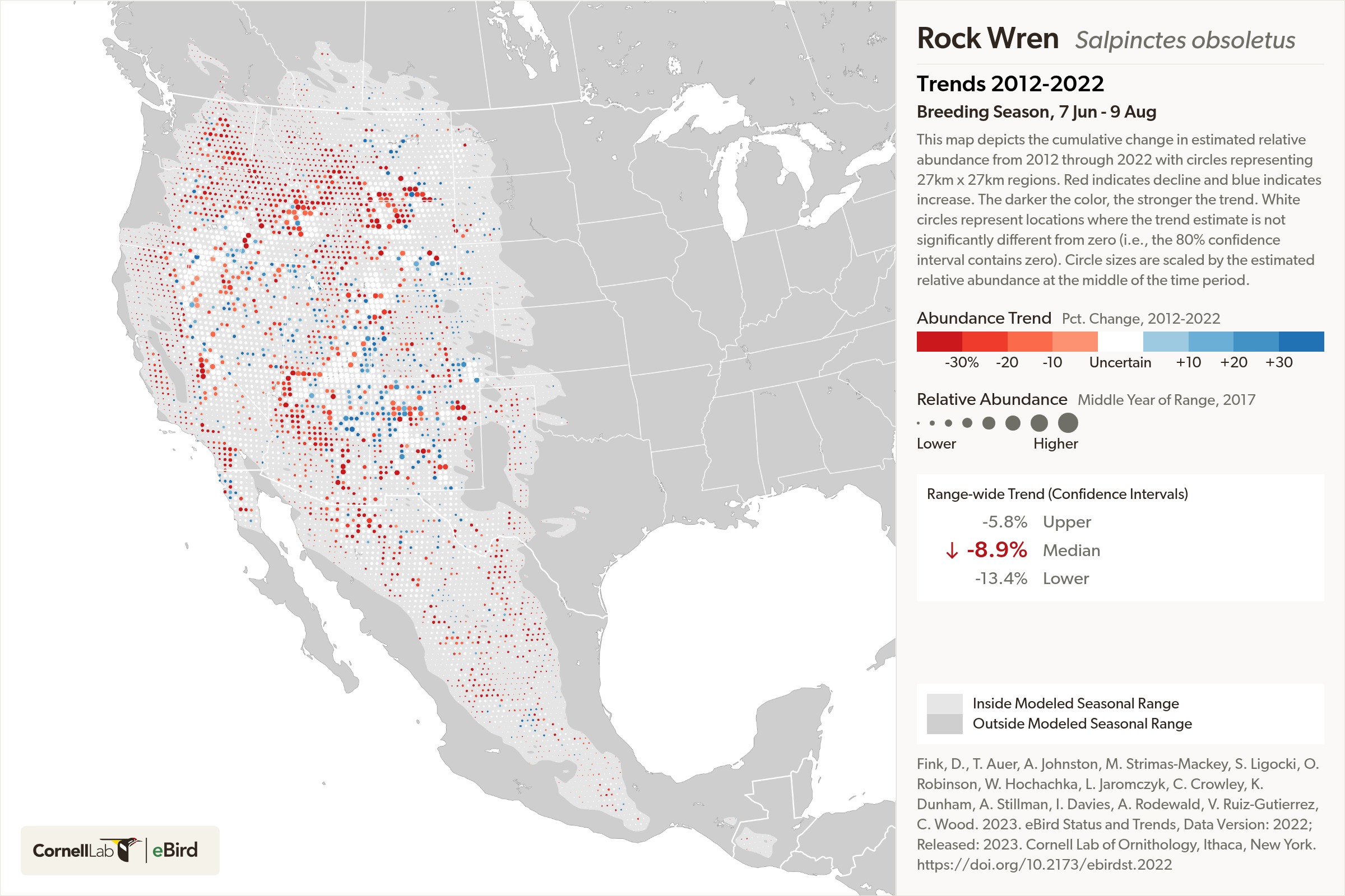
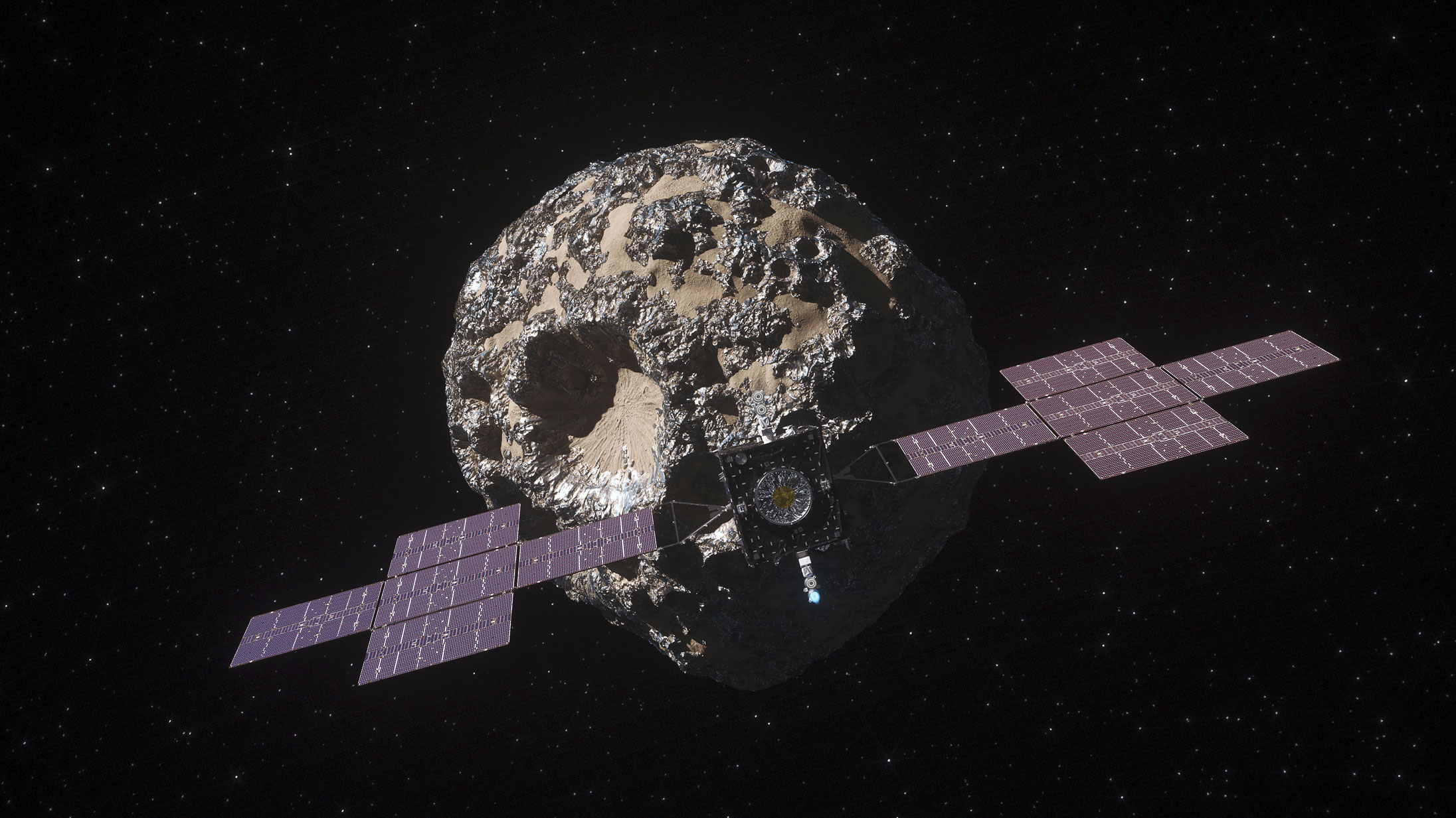
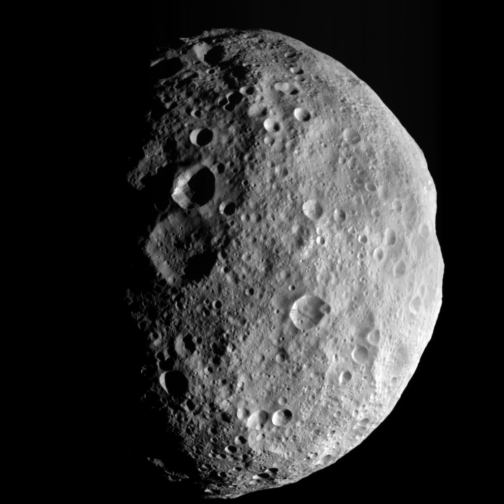
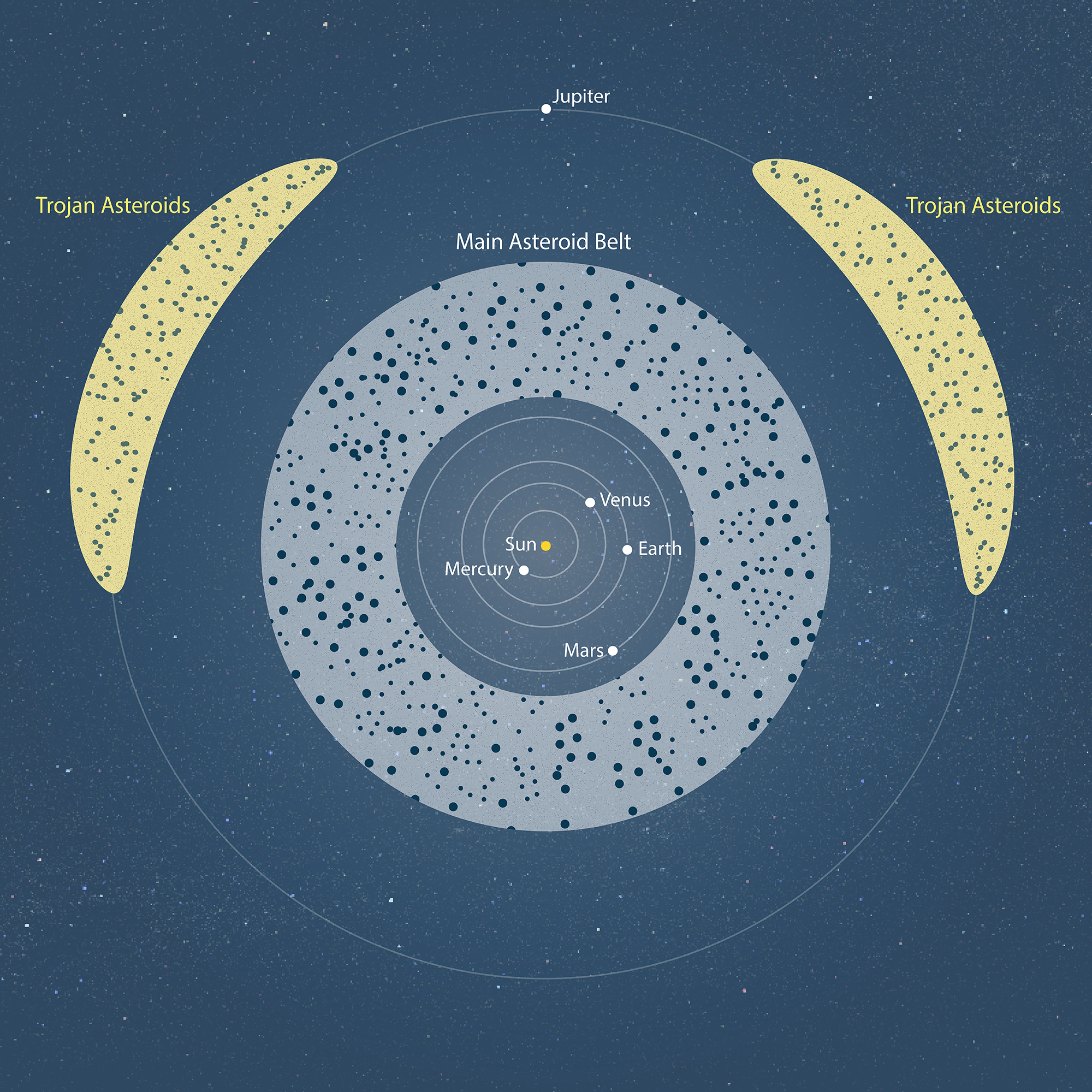
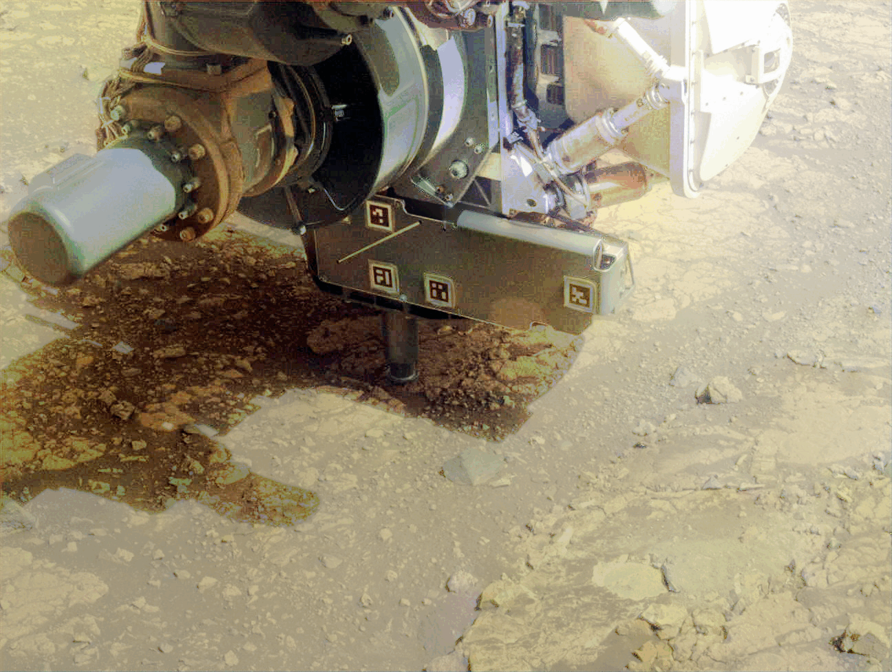
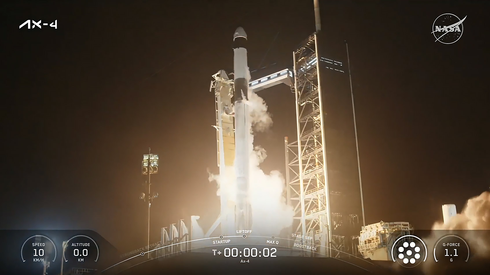
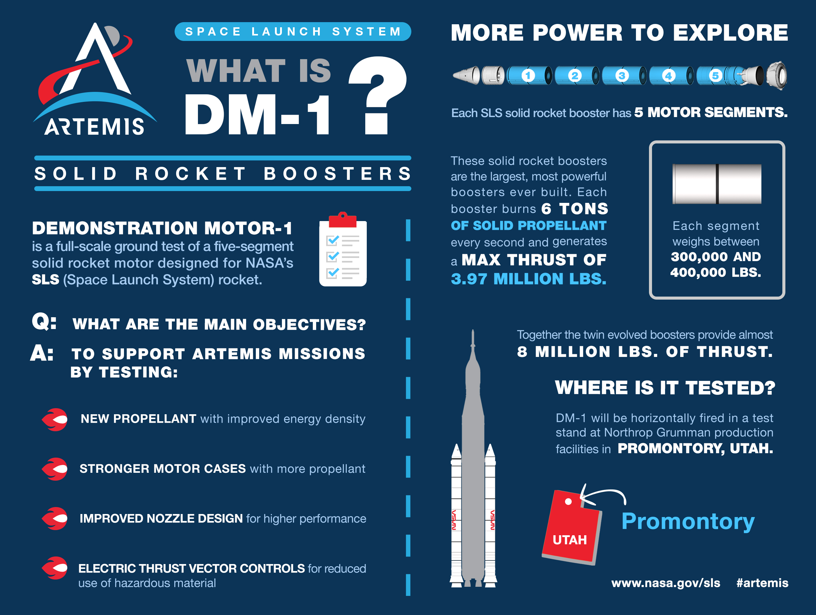
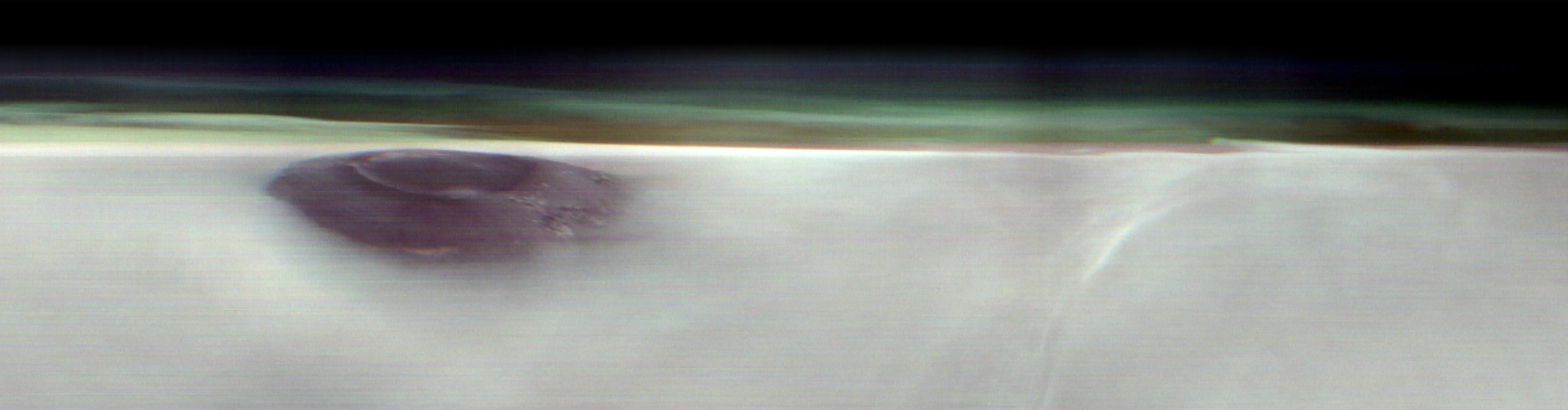
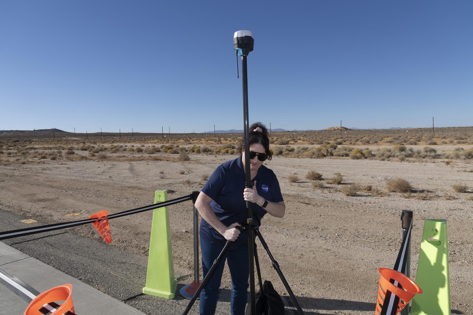
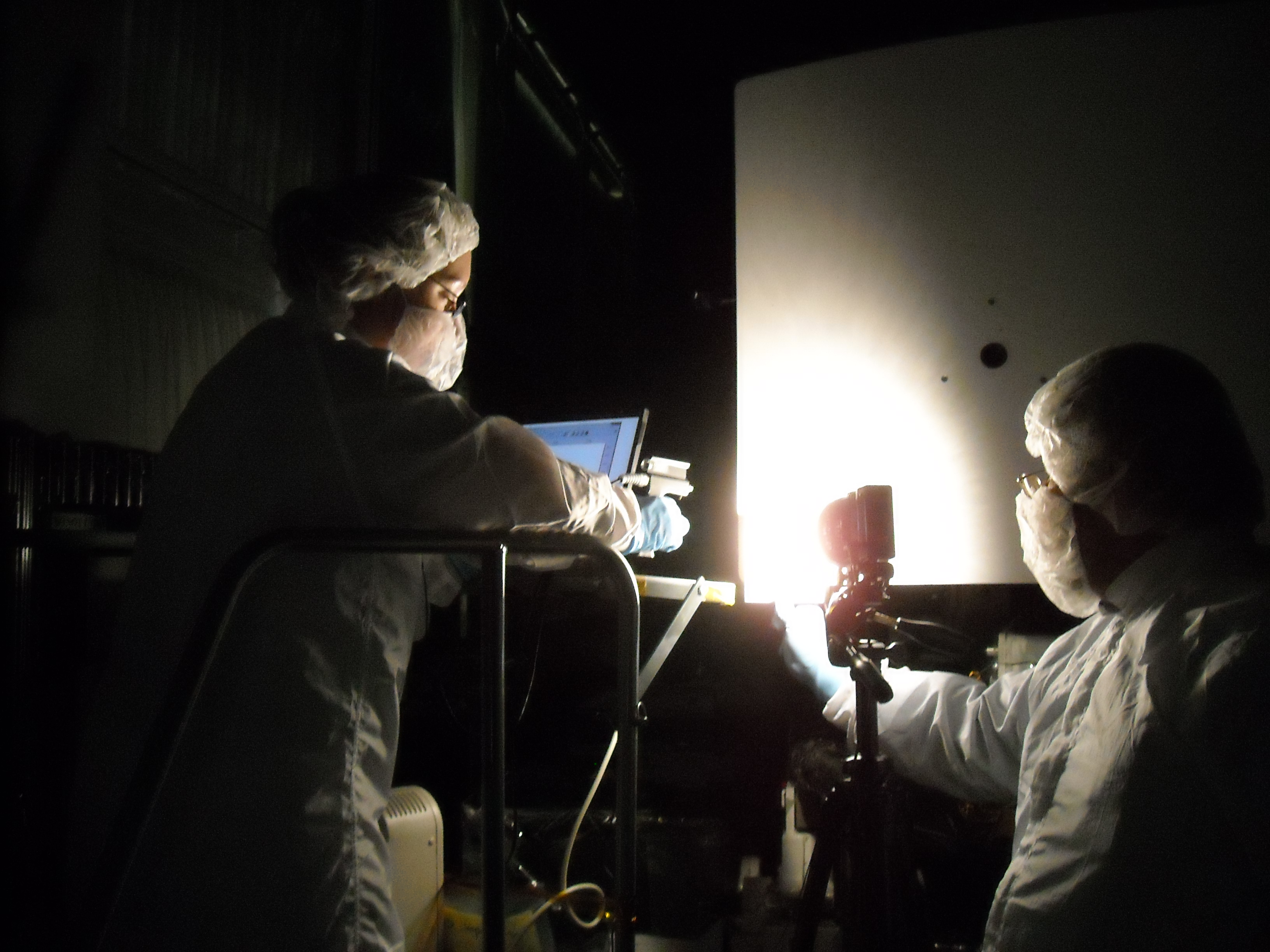
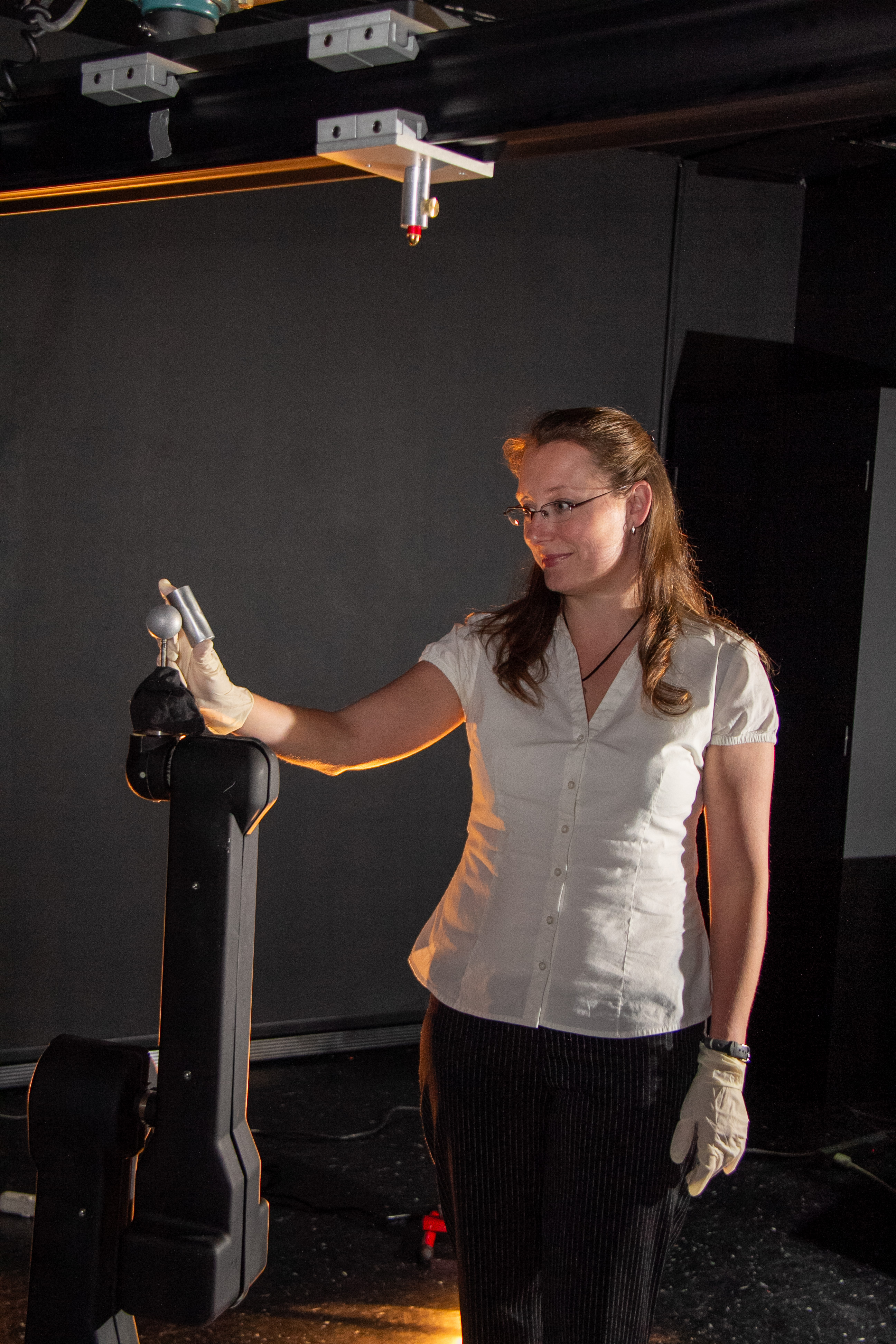
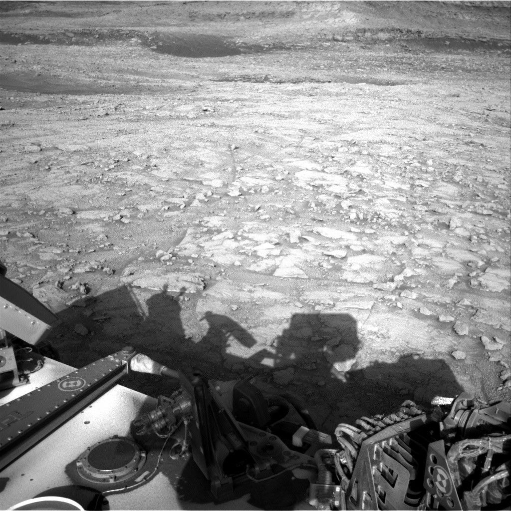
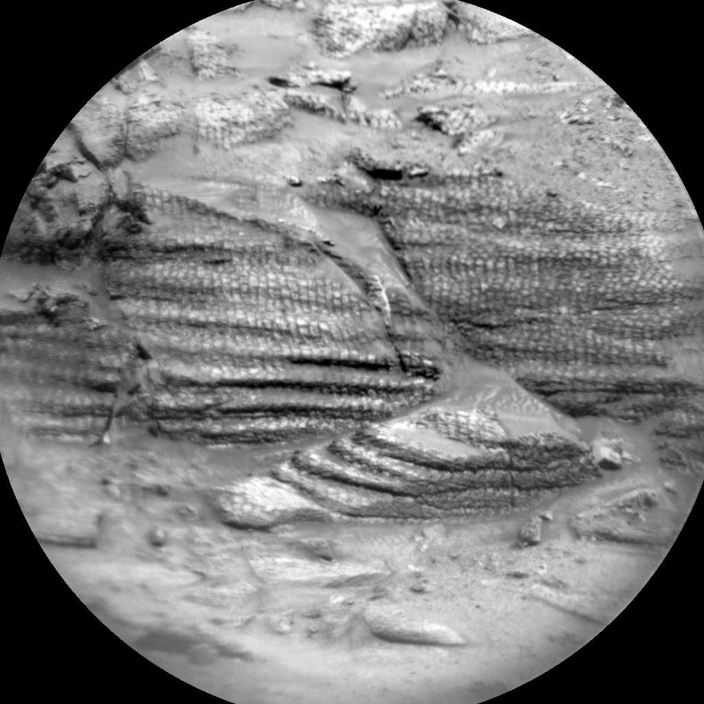