
NASA News
NASA Data Helps Maine Oyster Farmers Choose Where to Grow
- Earth
- Explore
- Science at Work
- Multimedia
- Data
- For Researchers
- About Us
When oyster farmer Luke Saindon went looking for a place to grow shellfish in Maine, he knew that picking the wrong patch of water could sink the farm before it began. So Saindon did something oyster farmers couldn’t have done a generation ago: He used NASA satellite data to view the coastline from space.
“Starting a farm is a big venture,” said Saindon, the director for The World Is Your Oyster farm in Wiscasset, Maine. “If you choose the wrong spot, you can blow through a lot of money without ever bringing oysters to market.”
NASA satellites had been passing over these waters for years, recording temperatures and other conditions. Using a site-selection tool created by University of Maine researchers, Saindon examined satellite maps showing where water temperatures and food levels might be best for growing oysters. The maps pointed him toward a wide, shallow bay near his home. Four years later, the farm is still there — and the oysters are thriving.
Luke Saindon, director of The World Is Your Oyster farm in Wiscasset, Maine, checks oyster cages on the farm’s floating platform.© Jacqueline Clarke/The World Is Your Oyster, used with permissionSaindon believes that using the satellite data to select his oyster farm site resulted in faster-than-average growth rates.
“This is an example of how NASA’s Earth science program supports our nation,” said Chris Neigh, the Landsat 8 and 9 project scientist at NASA’s Goddard Space Flight Center in Greenbelt, Maryland. “We collect global data, but its value grows when it’s used locally to help communities work smarter and make their livelihoods more sustainable.”
From orbit to oysterThat same satellite-based approach is now the foundation of a study published Jan. 15 in the journal Aquaculture. Led by University of Maine scientists Thomas Kiffney and Damian Brady, the research demonstrates how temperature data from Landsat — the joint NASA and U.S. Geological Survey mission — combined with European Sentinel-2 satellite estimates of oyster food availability, namely plankton, can predict how quickly eastern oysters (Crassostrea virginica) reach market size.
The team built a satellite data–driven model of how oysters divide their energy among growth, survival, and reproduction. Feed the model sea surface temperature and satellite estimates of chlorophyll and particulate organic matter — signals of how much plankton and other edible particles are in the water — and it predicts how fast oysters will grow, a big step beyond just spotting good or bad sites for farms.
“By showing where oysters grow faster, the model can help farmers plan ahead,” Kiffney said. “That could mean better decisions about when to seed, when to harvest, and how much product to expect, all of which reduces financial risk.”
That kind of insight is increasingly valuable in Maine, where oyster farming has grown rapidly over the last decade. From 2011 to 2021, the industry’s value increased 78%, rising from about $2.5 million to more than $10 million. As the sector scales up, understanding the finer details of Maine’s coastal waters has become essential — and that’s where NASA satellites come in.
The stakes are considerable. “It takes two to three years of scoping in order to get your permit to grow, and then it can take two years for those oysters to reach market,” Brady said. “So if you’ve chosen the wrong site, you’re four years in the hole right off the bat.”
Sharper eyes on coastMaine’s coastline measures about 3,400 miles (5,500 kilometers) if you follow the tide line. It is a coast of drowned valleys and glacier-scoured granite. Water depth, temperature, and circulation can shift dramatically within a few miles. This complexity makes oyster site selection notoriously difficult, and some satellites that see the coast in broad strokes miss the small, patchy places where oysters live.
“What makes Landsat so powerful for aquaculture is its ability to see finer-scale patterns along the coast,” where farmers put oyster cages in the water, Neigh said.
This false-color image from Landsat 9’s Thermal Infrared Sensor, acquired Oct. 11, 2025, shows the thermal signature of waters off the coast of Maine — revealing finer-scale temperature differences between neighboring coves. Cooler waters appear purple and blue, while warmer water shows up in orange and yellow.NASA/Ross Walter and Allison NussbaumLandsat 8 and 9’s pixels — 98 to 328 feet (30 to 100 meters) across — are able to distinguish more subtle temperature differences between neighboring coves. For a cold-blooded oyster, those distinctions can translate into months of growth. Warm water accelerates feeding and shell development. Cold water slows both.
A challenge for satellites is clouds. Maine’s sky is frequently overcast, and together Landsat 8 and 9 pass over any given point only every eight days. To work around this, the research team analyzed 10 years of Landsat data (2013–2023) and built seasonal “climatologies,” or average temperature patterns for every 98-foot (30-meter) pixel along the coast. Sentinel-2 imagery added estimates of chlorophyll and particulate organic matter, the drifting microscopic food that oysters pull from the water column with rhythmic contractions of their gills.
Field tests at multiple sites showed the technique’s accuracy. “We validated the model against seven years of field data,” Brady said. “It’s a strong indication that these remotely sensed products can inform not just where to grow, but how long it will take to harvest.”
Turning satellite science into tools for growersThe University of Maine team is now developing an online tool to put this model into practice. A grower will be able to click on a coastal location and receive an estimate for time-to-market.
The researchers also assist with workshops through Maine’s Aquaculture in Shared Waters program, teaching farmers how to interpret temperature and water clarity data and apply them to their own sites.
Monique Boutin, an aquaculture technician with The World Is Your Oyster farm, sorts oysters during harvest work on the water in Maine.© Nina Boutin/The World Is Your Oyster, used with permissionFor farmers like Saindon, that translates into something simpler: confidence and efficiency. “Having these kinds of tools lowers the barrier for new people to get into aquaculture,” he said. “It gives you peace of mind that you’re not just guessing.”
The Maine project is helping pave the way for other NASA missions. The PACE satellite (Plankton, Aerosol, Cloud, ocean Ecosystem) launched in 2024 and is now delivering hyperspectral observations of coastal waters. Where earlier sensors could estimate how much plankton was present, PACE can begin to identify the different plankton species themselves. For oysters, mussels, and other filter feeders, that specificity matters. Not all plankton are equal food: Different kinds offer different nutrition, and some plankton are harmful to oysters.
A next step will be turning that richer picture of coastal life into forecasts people working on the water can use, helping farmers trade some of the coast’s mystery for evidence they can apply to their harvest.
By Emily DeMarco
NASA’s Goddard Space Flight Center, Greenbelt, Md.
Share Details Last Updated Jan 15, 2026 EditorChristina CampenContactEmily DeMarcoemily.p.demarco@nasa.govLocationGoddard Space Flight Center Related Terms Keep Exploring Discover More Topics From NASA EarthYour home. Our Mission. And the one planet that NASA studies more than any other.
Earth ObservatoryNASA’s Earth Observatory brings you the Earth, every day: images, stories, and discoveries about the environment, Earth systems, and climate.
Explore Earth Science
Earth Science in ActionNASA’s unique vantage point helps us inform solutions to enhance decision-making, improve livelihoods, and protect our planet.
Hubble Spies Stellar Blast Setting Clouds Ablaze
This new NASA Hubble Space Telescope image captures a jet of gas from a forming star shooting across the dark expanse. The bright pink and green patches running diagonally through the image are HH 80/81, a pair of Herbig-Haro (HH) objects previously observed by Hubble in 1995. The patch to the upper left is part of HH 81, and the bottom streak is part of HH 80.
Herbig-Haro objects are bright, glowing regions that occur when jets of ionized gas ejected by a newly forming star collide with slower, previously ejected outflows of gas from that star. HH 80/81’s outflow stretches over 32 light-years, making it the largest protostellar outflow known.
Protostars are fed by infalling gas from the surrounding environment, some of which can be seen in residual “accretion disks” orbiting the forming star. Ionized material within these disks can interact with the protostars’ strong magnetic fields, which channel some of the particles toward the pole and outward in the form of jets.
As the jets eject material at high speeds, they can produce strong shock waves when the particles collide with previously ejected gas. These shocks heat the clouds of gas and excite the atoms, causing them to glow in what we see as HH objects.
HH 80/81 are the brightest HH objects known to exist. The source powering these luminous objects is the protostar IRAS 18162-2048. It’s roughly 20 times the mass of the Sun, and it’s the most massive protostar in the entire L291 molecular cloud. From Hubble data, astronomers measured the speed of parts of HH 80/81 to be over 1,000 km/s, the fastest recorded outflow in both radio and visual wavelengths from a young stellar object. Unusually, this is the only HH jet found that is driven by a young, very massive star, rather than a type of young, low-mass star.
The sensitivity and resolution of Hubble’s Wide Field Camera 3 was critical to astronomers, allowing them to study fine details, movements, and structural changes of these objects. The HH 80/81 pair lies 5,500 light-years away within the Sagittarius constellation.
Hubble’s Album of Planet-Forming Disks
- Hubble Home
- Overview
- Impact & Benefits
- Science
- Observatory
- Team
- Multimedia
- News
- More
3 min read
Hubble’s Album of Planet-Forming Disks Hubble images of protoplanetary disks in visible and infrared light show dusty regions around newly developing stars where planets may form.Left: NASA, ESA, and K. Stapelfeldt (Jet Propulsion Laboratory); Processing: Gladys Kober (NASA/Catholic University of America) Right: NASA, ESA, and T. Megeath (University of Toledo); Processing: Gladys Kober (NASA/Catholic University of America)This collection of new images taken by NASA’s Hubble Space Telescope showcases protoplanetary disks, the swirling masses of gas and dust that surround forming stars, in both visible and infrared wavelengths. Through observations of young stellar objects like these, Hubble helps scientists better understand how stars form.
Jets of gas blast from protostars in these visible-light images. HH 390’s outflow is accompanied by a one-sided nebula, evidence that the protoplanetary disk is not viewed edge-on from our perspective. Tau 042021 is a large, symmetrical disk seen edge-on, and is in a late stage of dust evolution, since the dust particles have clumped together into larger grains. HH 48 is a binary protostar system in which gravitational tidal forces from the larger star appear to be influencing the disk of the secondary object. ESO Hα574 is a very compact disk with a “collimated” ― or beam-like and linear ― outflow, and one of the faintest edge-on disks yet recognized.NASA, ESA, and K. Stapelfeldt (Jet Propulsion Laboratory); Processing: Gladys Kober (NASA/Catholic University of America) Download this image (34.6 MB)These visible-light images depict dark, planet-forming dust disks around a hidden, newly developing star, called a protostar. Bipolar jets of fast-moving gases, traveling at about 93 miles (150 km) per second, shoot from both ends of the protostar. The top two images are of protostars found about 450 light-years away in the Taurus Molecular Cloud, while the bottom two are almost 500 light-years away in the Chameleon I star-forming region.
Stars form out of collapsing clouds of gas and dust. As surrounding gas and dust falls toward the protostar, some of it forms a rotating disk around the star that continues to feed the growing object. Planets form from the remaining gas and dust orbiting the star. The bright yellow regions above and below the spinning disks are reflection nebulae, gas and dust lit up by the light of the star.
The jets that are released from the magnetic poles of the stars are an important part of their formation process. The jets, channeled by the protostar’s powerful magnetic fields, disperse angular momentum, which is due to rotational movement of the object. This allows the protostar to spin slowly enough for material to collect. In the images, some of the jets appear to broaden. This occurs when the fast jet collides with the surrounding gas and causes it to glow, an effect called a shock emission.
Bright central protostars and the shadows of their dusty disks appear in these infrared images.NASA, ESA, and T. Megeath (University of Toledo); Processing: Gladys Kober (NASA/Catholic University of America) Download this image (36.6 MB)These edge-on views of protostars in infrared light also reveal thick, dusty protoplanetary disks. The dark areas may look like very large disks, but they are actually much wider shadows cast in the surrounding envelope by the central disks. The bright haze throughout the image comes from light scattering off of the surrounding cloud’s dust grains. The top right and bottom left stars reside in the Orion Molecular Cloud complex about 1,300 light-years away, and the top left and bottom right stars lie in the Perseus Molecular Cloud roughly 1,500 light-years away.
In its early stages, these disks draw from the dust that remains around the forming stars. Unlike visible light, infrared light can travel through this “protostellar envelope.” The protostars in the visible images above are further along in their evolution, so much of the dusty envelope has dissipated. Otherwise, they could not be seen in visible wavelengths.
Viewed in infrared light, the central star is visible through the thick dust of the protoplanetary disks. Bipolar jets are also present but not visible because the hot gas emission isn’t strong enough for Hubble to detect.
HOPS 150 in the top right is actually in a binary system, in orbit with another young protostar. HOPS 150’s companion, HOPS 153, is not pictured in this image.
From a wider Hubble survey of Orion protostars, including HOPS 150 and HOPS 367, astronomers found that regions with a higher density of stars tend to have more companion stars. They also found a similar number of companions between main-sequence (active, hydrogen-fusing stars) and their younger counterparts.
New images added every day between January 12-17, 2026! Follow @NASAHubble on social media for the latest Hubble images and news and see Hubble’s Stellar Construction Zones for more images of young stellar objects.
Facebook logo @NASAHubble @NASAHubble Instagram logo @NASAHubble Explore More Finding Plantary Construction Zones Hubble’s Exoplanets Recognizing Worlds Beyond Our SunMedia Contact:
Claire Andreoli
NASA’s Goddard Space Flight Center, Greenbelt, MD
claire.andreoli@nasa.gov
Since its 1990 launch, the Hubble Space Telescope has changed our fundamental understanding of the universe.
Hubble’s Stellar Construction Zones
Explore the Night Sky
Hubble News
NASA’s SpaceX Crew-11 Mission Returns, Splashes Down off California
NASA’s SpaceX Crew-11 mission safely splashed down early Thursday morning in the Pacific Ocean off the coast of San Diego, concluding a more than five-month mission aboard the International Space Station.
NASA astronauts Zena Cardman and Mike Fincke, JAXA (Japan Aerospace Exploration Agency) astronaut Kimiya Yui, and Roscosmos cosmonaut Oleg Platonov returned to Earth at 12:41 a.m. PST. Teams aboard SpaceX recovery vessels retrieved the spacecraft and its crew shortly after landing.
“I couldn’t be prouder of our astronauts and the teams on the ground at NASA, SpaceX, and across our international partnerships,” said NASA Administrator Jared Isaacman. “Their professionalism and focus kept the mission on track, even with an adjusted timeline. Crew-11 completed more than 140 science experiments that advance human exploration. Missions like Crew-11 demonstrate the capability inherent in America’s space program—our ability to bring astronauts home as needed, launch new crews quickly, and continue pushing forward on human spaceflight as we prepare for our historic Artemis II mission, from low Earth orbit to the Moon and ultimately Mars.”
Crew-11 returned home about a month earlier than planned because of a medical concern teams are monitoring with one of the crew members, who remains stable. Due to medical privacy, it is not appropriate for NASA to share more details about the crew member. Prior to return, NASA previously coordinated for all four crew members to be transported to a local hospital for additional evaluation, taking advantage of medical resources on Earth to provide the best care possible.
Following the planned overnight hospital stay, the crew members will return to NASA’s Johnson Space Center in Houston and undergo standard postflight reconditioning and evaluations.
The Crew-11 mission lifted off at 11:43 a.m. EDT on Aug.1, 2025, from Launch Complex 39A at NASA’s Kennedy Space Center in Florida. About 15 hours later, the crew’s SpaceX Dragon spacecraft docked to the orbital outpost at 1:27 a.m. CDT on Aug. 2.
During their 167-day mission, the four crew members traveled nearly 71 million miles and completed more than 2,670 orbits around Earth. The Crew-11 mission was Fincke’s fourth spaceflight, Yui’s second, and the first for Cardman and Platonov. Fincke has logged 549 days in space, ranking him fourth among all NASA astronauts for cumulative days in space.
Along the way, Crew-11 logged hundreds of hours of research, maintenance, and technology demonstrations. The crew members also celebrated the 25th anniversary of continuous human presence aboard the orbiting laboratory on Nov. 2, 2025. Research conducted aboard the space station advances scientific knowledge and demonstrates new technologies that enable us to prepare for human exploration of the Moon and Mars.
NASA’s Commercial Crew Program provides reliable access to space, maximizing the use of the International Space Station for research and development by partnering with private U.S. companies, including SpaceX, to transport astronauts to and from the space station.
Learn more about NASA’s Commercial Crew Program at:
https://www.nasa.gov/commercialcrew
-end-
Joshua Finch / Jimi Russell
Headquarters, Washington
202-358-1100
joshua.a.finch@nasa.gov / james.j.russell@nasa.gov
Sandra Jones / Joseph Zakrzewski
Johnson Space Center, Houston
281-483-5111
sandra.p.jones@nasa.gov / joseph.a.zakrzewski@nasa.gov
Steven Siceloff
Kennedy Space Center, Florida
321-867-2468
steven.p.siceloff@nasa.gov
Clouds Swimming over Lago Argentino
- Earth
- Earth Observatory
- Image of the Day
- EO Explorer
- Topics
- More Content
- About
Coverage, Briefing Set for NASA’s Artemis II Moon Rocket Roll to Pad
NASA’s integrated SLS (Space Launch System) rocket and Orion spacecraft for the Artemis II mission is inching closer to launch – literally.
The agency is targeting no earlier than 7 a.m. EST, Saturday, Jan. 17, to begin the multi-hour trek from the Vehicle Assembly Building to Launch Pad 39B at NASA’s Kennedy Space Center in Florida.
A pre rollout mission news conference, live feed of rollout, and a media gaggle will stream on NASA’s YouTube channel. Individual streams for each of these events will be available from that page. Learn how to stream NASA content through a variety of online platforms, including social media.
The time of rollout is subject to change if additional time is needed for technical preparations or weather.
All times are Eastern. Events are as follows:
Friday, Jan. 16:
12 p.m.: Artemis II Rollout, Mission Overview News Conference
- John Honeycutt, Artemis II mission management team chair
- Charlie Blackwell-Thompson, Artemis launch director, Exploration Ground Systems
- Jeff Radigan, Artemis II lead flight director, Flight Operations Directorate
- Lili Villarreal, landing and recovery director, Exploration Ground Systems
- Jacob Bleacher, chief exploration scientist, Exploration Systems Development Mission Directorate
Saturday, Jan. 17:
7 a.m.: Rollout, Artemis II Live Views from Kennedy Space Center feed begins
9 a.m.: Artemis II Crew Rollout Media Event
- NASA Administrator Jared Isaacman and the Artemis II crew, including NASA astronauts Reid Wiseman, Victor Glover, and Christina Koch, and CSA (Canadian Space Agency) astronaut Jeremy Hansen, will answer questions about their preparations and the mission for media in-person at the countdown clock.
NASA’s crawler-transporter 2 will carry the 11-million-pound stack at about one mile per hour along the four-mile route from the Vehicle Assembly Building to Launch Pad 39B, on a journey that will take up to 12 hours.
To participate in the news conference by telephone, media must RSVP no later than two hours before the start to: ksc-newsroom@mail.nasa.gov.
These events will be open in-person only to media previously credentialed for launch. The deadline has passed for in-person accreditation for Artemis II events at Kennedy.
Rollout to the pad marks another milestone leading up to the Artemis II mission. In the coming weeks, NASA will complete final preparations of the rocket and, if needed, rollback SLS and Orion to the Vehicle Assembly Building for additional work. While the Artemis II launch window opens as early as Friday, Feb. 6, the mission management team will assess flight readiness after the wet dress rehearsal across the spacecraft, launch infrastructure, and the crew and operations teams before selecting a launch date.
Follow NASA’s Artemis blog for mission updates.
Through Artemis, NASA will send astronauts to explore the Moon for scientific discovery, economic benefits, and to build the foundation for the first crewed missions to Mars.
Learn more about Artemis at:
-end-
Rachel Kraft / Lauren Low
Headquarters, Washington
202-358-1600
rachel.h.kraft@nasa.gov / lauren.e.low@nasa.gov
Tiffany Fairley
Kennedy Space Center, Fla.
321-867-2468
tiffany.l.fairley@nasa.gov
New York–Newark–Jersey City Metropolitan Area
The New York–Newark–Jersey City Metropolitan Statistical Area, which spans 23 counties across New York, New Jersey, and Connecticut and has a population of about 19.9 million, is pictured at approximately 3:29 a.m. local time Dec. 20, 2025, from the International Space Station as it orbited 262 miles above the Atlantic coast.
Crew members aboard the orbital lab have produced hundreds of thousands of images of the land, oceans, and atmosphere of Earth, and even of the Moon through Crew Earth Observations. Their photographs of Earth record how the planet changes over time due to human activity and natural events. This allows scientists to monitor disasters and direct response on the ground and study a number of phenomena, from the movement of glaciers to urban wildlife.
Image credit: NASA
La NASA publica datos de la temperatura global
Read this press release in English here.
La temperatura global de la superficie terrestre en 2025 fue un poco más cálida que en 2023 pero, dentro de los márgenes de error, ambos años está prácticamente empatados, según un análisis realizado por científicos de la NASA. Desde que comenzaron los registros en 1880, 2024 sigue siendo el año más caluroso.
Las temperaturas globales en 2025 fueron más frías que en 2024, con temperaturas promedio de 1,19° Celsius (2,14° Fahrenheit) por encima del promedio para el período de 1951 a 1980.
El análisis del Instituto Goddard de Estudios Espaciales de la NASA incluye datos de la temperatura del aire obtenidos por más de 25.000 estaciones meteorológicas en todo el mundo, así como por instrumentos a bordo de barcos y boyas que miden la temperatura de la superficie del mar, y estaciones de investigación en la Antártida. Los datos son analizados utilizando métodos que toman en cuenta la distribución cambiante de las estaciones de medición de temperatura y los efectos del calentamiento urbano que podrían sesgar los cálculos.
Además, análisis independientes realizados por la Administración Nacional Oceánica y Atmosférica (NOAA, por sus siglas en inglés), la plataforma Berkeley Earth, el Centro Hadley (que forma parte del servicio meteorológico nacional del Reino Unido) y los Servicios Climáticos Copernicus de Europa han concluido que la temperatura global de la superficie para 2025 ha sido la tercera más calurosa que se haya registrado. Estos científicos utilizan gran parte de los mismos datos de temperatura en sus análisis, pero emplean diferentes metodologías y modelos; todos ellos muestran la misma tendencia al calentamiento continuo.
El conjunto completo de datos de la NASA sobre las temperaturas de la superficie global, así como los detalles de cómo los científicos de la NASA llevaron a cabo el análisis, están disponibles públicamente en línea (en inglés).
Para obtener más información sobre los programas de ciencias de la Tierra de la NASA, visita el sitio web:
https://ciencia.nasa.gov/tierra
-fin-
Liz Vlock / María José Viñas
Sede central, Washington
202-358-1600
elizabeth.a.vlock@nasa.gov / maria-jose.vinasgarcia@nasa.gov
Peter Jacobs
Centro de Vuelo Espacial Goddard, Greenbelt, MD
301-286-0535
peter.jacobs@nasa.gov
NASA Releases Global Temperature Data
Lee este comunicado de prensa en español aquí.
Earth’s global surface temperature in 2025 was slightly warmer than 2023 – but within the margin of error the two years are effectively tied according to an analysis by NASA scientists. Since record-keeping began in 1880, the hottest year on record remains 2024.
Global temperatures in 2025 were cooler than 2024, with average temperatures of 2.14 degrees Fahrenheit (1.19 degrees Celsius) above the 1951 to 1980 average.
The analysis from NASA’s Goddard Institute for Space Studies includes air temperature data acquired by more than 25,000 meteorological stations around the world, from ship- and buoy-based instruments measuring sea surface temperature, and Antarctic research stations. The data are analyzed using methods that account for the changing distribution of temperature stations and for urban heating effects that could skew the calculations.
Additionally, independent analyses by the National Oceanic and Atmospheric Administration, Berkeley Earth, the Hadley Centre (part of the United Kingdom’s weather forecasting Met Office), and Copernicus Climate Services in Europe have concluded the global surface temperature for 2025 was the third warmest on record. These scientists use much of the same temperature data in their analyses but employ different methodologies and models, which exhibit the same ongoing warming trend.
NASA’s full dataset of global surface temperatures, as well as details of how agency scientists conducted the analysis are available online.
For more information about NASA’s Earth science programs, visit:
https://science.nasa.gov/earth
-end-
Liz Vlock
Headquarters, Washington
202-358-1600
elizabeth.a.vlock@nasa.gov
Peter Jacobs
Goddard Space Flight Center, Greenbelt, Md.
301-286-3308
peter.jacobs@nasa.gov
Hubble Observes Stars Flaring to Life in Orion
- Hubble Home
- Overview
- Impact & Benefits
- Science
- Observatory
- Team
- Multimedia
- News
- More
3 min read
Hubble Observes Stars Flaring to Life in Orion Protostar HOPS 181 is buried in layers of dusty gas clouds, but its energy shapes the material that surrounds it. NASA, ESA, and T. Megeath (University of Toledo); Processing: Gladys Kober (NASA/Catholic University of America) A protostar wrapped in obscuring dust creates a cavity with glowing walls while its jet streams into space. NASA, ESA, and T. Megeath (University of Toledo); Processing: Gladys Kober (NASA/Catholic University of America) A curving cavity in a cloud of gas has been hollowed out by a protostar in this Hubble image. NASA, ESA, and T. Megeath (University of Toledo); Processing: Gladys Kober (NASA/Catholic University of America)
Just-forming stars, called protostars, dazzle a cloudy landscape in the Orion Molecular Cloud complex (OMC). These three new images from NASA’s Hubble Space Telescope were taken as part of an effort to learn more about the envelopes of gas and dust surrounding the protostars, as well as the outflow cavities where stellar winds and jets from the developing stars have carved away at the surrounding gas and dust.
Scientists used these Hubble observations as part of a broader survey to study protostellar envelopes, or the gas and dust around the developing star. Researchers found no evidence that the outflow cavities were growing as the protostar moved through the later stages of star formation. They also found that the decreasing accretion of mass onto the protostars over time and the low rate of star formation in the cool, molecular clouds cannot be explained by the progressive clearing out of the envelopes.
The OMC lies within the “sword” of the constellation Orion, roughly 1,300 light-years away.
Protostar HOPS 181 is buried in layers of dusty gas clouds, but its energy shapes the material that surrounds it. NASA, ESA, and T. Megeath (University of Toledo); Processing: Gladys Kober (NASA/Catholic University of America)This Hubble image shows a small group of young stars amidst molecular clouds of gas and dust. Near the center of the image, concealed behind the dusty clouds, lies the protostar HOPS 181. The long, curved arc in the top left of the image is shaped by the outflow of material coming from the protostar, likely from the jets of particles shot out at high speeds from the protostar’s magnetic poles. The light of nearby stars reflects off and is scattered by dust grains that fill the image, giving the region its soft glow.
Download this image (5.7 MB)
A protostar wrapped in obscuring dust creates a cavity with glowing walls while its jet streams into space. NASA, ESA, and T. Megeath (University of Toledo); Processing: Gladys Kober (NASA/Catholic University of America)
Download this image (6 MB)
The bright star in the lower right quadrant called CVSO 188 might seem like the diva in this image, but HOPS 310, located just to the left of center behind the dust, is the true hidden star. This protostar is responsible for the large cavity with bright walls that has been carved into the surrounding cloud of gas and dust by its jets and stellar winds. Running diagonally to the top right is one of the bipolar jets of the protostar. These jets consist of particles launched at high speeds from the protostar’s magnetic poles. Some background galaxies are visible in the upper right of the image.
A curving cavity in a cloud of gas has been hollowed out by a protostar in this Hubble image. NASA, ESA, and T. Megeath (University of Toledo); Processing: Gladys Kober (NASA/Catholic University of America)Download this image (5.7 MB)
The bright protostar to the left in this Hubble image is located within the Orion Molecular Clouds. Its stellar winds — ejected, fast-flowing particles that are spurred by the star’s magnetic field — have carved a large cavity in the surrounding cloud. In the top right, background stars speckle the image.
New images added every day between January 12-17, 2026! Follow @NASAHubble on social media for the latest Hubble images and news and see Hubble’s Stellar Construction Zones for more images of young stellar objects.
Facebook logo @NASAHubble @NASAHubble Instagram logo @NASAHubble Explore MoreExploring the Birth of Stars
Hubble’s Nebulae
Media Contact:
Claire Andreoli
NASA’s Goddard Space Flight Center, Greenbelt, MD
claire.andreoli@nasa.gov
Since its 1990 launch, the Hubble Space Telescope has changed our fundamental understanding of the universe.
Hubble’s Stellar Construction Zones
Explore the Night Sky
Hubble News
Fire on Ice: The Arctic’s Changing Fire Regime
- Earth
- Earth Observatory
- Image of the Day
- EO Explorer
- Topics
- More Content
- About
Fires on the Rise in the Far North
- Earth
- Earth Observatory
- Image of the Day
- EO Explorer
- Topics
- More Content
- About
La NASA transmitirá en directo el regreso y el amerizaje de Crew 11
Read this press release in English here.
La NASA y SpaceX prevén que, si las condiciones meteorológicas lo permiten, el desacoplamiento de la misión SpaceX Crew 11 de la agencia espacial estadounidense de la Estación Espacial Internacional se produzca no antes de las 5:05 p.m. EST (hora del este) del miércoles 14 de enero.
El 8 de enero, la NASA anunció su decisión de traer de vuelta a la Tierra antes de lo previsto a los integrantes de la misión SpaceX Crew 11 de la agencia desde la estación espacial, mientras los equipos técnicos siguen de cerca un problema médico que afecta a un miembro de la tripulación que actualmente vive y trabaja a bordo del laboratorio orbital. Debido a la confidencialidad médica, no es apropiado que la NASA comparta más detalles sobre el miembro de la tripulación, quien se encuentra estable.
Está planeado que los astronautas de la NASA Zena Cardman y Mike Fincke, el astronauta de JAXA (Agencia Japonesa de Exploración Aeroespacial) Kimiya Yui y el cosmonauta de Roscosmos Oleg Platonov americen frente a la costa de California a las 3:41 a.m. del jueves 15 de enero.
Los responsables de la misión continúan supervisando las condiciones en la zona de recuperación, ya que el desacoplamiento de la nave Dragon de SpaceX depende de las condiciones operativas de la nave espacial, la preparación del equipo de recuperación, las condiciones meteorológicas, el estado del mar y otros factores. La NASA y SpaceX seleccionarán una hora y un lugar concretos para el amerizaje cuando se acerque la fecha del desacoplamiento de la nave espacial de Crew 11.
La cobertura en directo (en inglés) de la NASA del regreso y las actividades relacionadas se retransmitirá en NASA+, Amazon Prime, y el canal de YouTube de la agencia. Aprenda cómo transmitir contenido de la NASA a través de diversas plataformas en línea, incluidas las redes sociales.
La cobertura de la NASA es la siguiente (todas las horas son del este y están sujetas a cambios en función de las operaciones en tiempo real):
Miércoles, 14 de enero
3 p.m. – Comienza la cobertura del cierre de escotilla en NASA+, Amazon Prime, y YouTube.
3:30 p.m. – Cierre de escotilla
4:45 p.m. – Comienza la cobertura del desacoplamiento en NASA+, Amazon Prime, y YouTube.
5:05 p.m. – Desacoplamiento
Tras la finalización de la cobertura del desacoplamiento, la NASA distribuirá las conversaciones (solo en formato audio) entre la tripulación Crew 11, la estación espacial y los controladores de vuelo durante el tránsito de la nave Dragon alejándose del complejo orbital.
Jueves, 15 de enero
2:15 a.m. – Comienza la cobertura del regreso en NASA+, Amazon Prime, y YouTube.
2:51 a.m. – Encendido de desorbitado
3:41 a.m. – Amerizaje
5:45 a.m. – El administrador de la NASA, Jared Isaacman, liderará una rueda de prensa sobre el regreso a la Tierra que se transmitirá en directo a través de NASA+, Amazon Prime, y el canal de YouTube de la agencia.
Para participar virtualmente en la conferencia de prensa, los medios de comunicación deben ponerse en contacto con la sala de prensa del Centro Espacial Johnson de la NASA para obtener los detalles de la llamada antes de las 5 p.m. CST (hora del centro) del 14 de enero, enviando un correo electrónico a jsccommu@mail.nasa.gov o llamando al +1 281-483-5111. Para hacer preguntas, los medios de comunicación deben llamar al menos 10 minutos antes del inicio de la conferencia. La política de acreditación de medios de comunicación de la agencia está disponible en línea (en inglés).
Encuentre la cobertura completa de la misión, el blog de tripulaciones comerciales de la NASA y más información sobre la misión Crew 11 (todo en inglés) en:
https://www.nasa.gov/commercialcrew
-fin-
Joshua Finch / Jimi Russell / María José Viñas
Sede central, Washington
+1 202-358-1100
joshua.a.finch@nasa.gov / james.j.russell@nasa.gov / maria-jose.vinasgarcia@nasa.gov
Sandra Jones / Joseph Zakrzewski
Centro Espacial Johnson, Houston
+1 281-483-5111
sandra.p.jones@nasa.gov / joseph.a.zakrzewski@nasa.gov
Steve Siceloff
Centro Espacial Kennedy, Fla.
+1 321-867-2468
steven.p.siceloff@nasa.gov
NASA to Provide Live Coverage of Crew-11 Return, Splashdown
Lee este comunicado de prensa en español aquí.
NASA and SpaceX are targeting no earlier than 5:05 p.m. EST, Wednesday, Jan. 14, for the undocking of the agency’s SpaceX Crew-11 mission from the International Space Station, pending weather conditions.
On Jan. 8, NASA announced its decision to return the agency’s SpaceX Crew-11 mission to Earth from the space station earlier than originally planned as teams monitor a medical concern with a crew member currently living and working aboard the orbital laboratory, who is stable. Due to medical privacy, it is not appropriate for NASA to share more details about the crew member.
NASA astronauts Zena Cardman and Mike Fincke, JAXA (Japan Aerospace Exploration Agency) astronaut Kimiya Yui, and Roscosmos cosmonaut Oleg Platonov are targeted to splash down off the coast of California at 3:41 a.m. on Thursday, Jan. 15.
Mission managers continue monitoring conditions in the recovery area, as undocking of the SpaceX Dragon depends on spacecraft readiness, recovery team readiness, weather, sea states, and other factors. NASA and SpaceX will select a specific splashdown time and location closer to the Crew-11 spacecraft undocking.
NASA’s live coverage of return and related activities will stream on NASA+, Amazon Prime, and the agency’s YouTube channel. Learn how to stream NASA content through a variety of online platforms, including social media.
NASA’s coverage is as follows (all times Eastern and subject to changed based on real-time operations):
Wednesday, Jan. 14
3 p.m. – Hatch closure coverage begins on NASA+, Amazon Prime, and YouTube.
3:30 p.m. – Hatch closing
4:45 p.m. – Undocking coverage begins on NASA+, Amazon Prime, and YouTube.
5:05 p.m. – Undocking
Following the conclusion of undocking coverage, NASA will distribute audio-only communications between Crew-11, the space station, and flight controllers during Dragon’s transit away from the orbital complex.
Thursday, Jan. 15
2:15 a.m. – Return coverage begins on NASA+, Amazon Prime, and YouTube.
2:51 a.m. – Deorbit burn
3:41 a.m. – Splashdown
5:45 a.m. – NASA Administrator Jared Isaacman will lead a Return to Earth news conference streaming live on NASA+, Amazon Prime, and the agency’s YouTube channel.
To participate virtually in the news conference, media must contact the NASA Johnson newsroom for call details by 5 p.m. CST, Jan. 14, at: jsccommu@mail.nasa.gov or 281-483-5111. To ask questions, media must dial in no later than 10 minutes before the start of the call. The agency’s media credentialing policy is available online.
Find full mission coverage, NASA’s commercial crew blog, and more information about the Crew-11 mission at:
https://www.nasa.gov/commercialcrew
-end-
Joshua Finch / Jimi Russell
Headquarters, Washington
202-358-1100
joshua.a.finch@nasa.gov / james.j.russell@nasa.gov
Sandra Jones / Joseph Zakrzewski
Johnson Space Center, Houston
281-483-5111
sandra.p.jones@nasa.gov / joseph.a.zakrzewski@nasa.gov
Steve Siceloff
Kennedy Space Center, Fla.
321-867-2468
steven.p.siceloff@nasa.gov
NASA’s Pandora Small Satellite Launched
In this photo from early January 2026, teams prepare to encapsulate NASA’s Pandora small satellite, NASA-sponsored Star-Planet Activity Research CubeSat (SPARCS), and the Black Hole Coded Aperture Telescope (BlackCAT) CubeSat, inside a SpaceX Falcon 9 payload fairing.
A SpaceX Falcon 9 rocket carrying NASA’s Pandora small satellite lifted off at 5:44 a.m. PST Sunday, Jan. 11, from Space Launch Complex 4 East at Vandenberg Space Force Base located on California’s central coast.
During its initial year, Pandora will provide an in-depth study of at least 20 known planets orbiting distant stars to determine the composition of their atmospheres — especially the presence of hazes, clouds, and water.
Image credit: SpaceX
NASA, Department of Energy to Develop Lunar Surface Reactor by 2030
NASA, along with the U.S. Department of Energy (DOE), announced Tuesday a renewed commitment to their longstanding partnership to support the research and development of a fission surface power system for use on the Moon under the Artemis campaign and future NASA missions to Mars.
A recently signed memorandum of understanding between the agencies solidifies this collaboration and advances President Trump’s vision of American space superiority by deploying nuclear reactors on the Moon and in orbit, including the development of a lunar surface reactor by 2030. This effort ensures the United States leads the world in space exploration and commerce.
“Under President Trump’s national space policy, America is committed to returning to the Moon, building the infrastructure to stay, and making the investments required for the next giant leap to Mars and beyond,” said NASA Administrator Jared Isaacman. “Achieving this future requires harnessing nuclear power. This agreement enables closer collaboration between NASA and the Department of Energy to deliver the capabilities necessary to usher in the Golden Age of space exploration and discovery.”
NASA and DOE anticipate deploying a fission surface power system capable of producing safe, efficient, and plentiful electrical power that will be able to operate for years without the need to refuel. The deployment of a lunar surface reactor will enable future sustained lunar missions by providing continuous and abundant power, regardless of sunlight or temperature.
“History shows that when American science and innovation come together, from the Manhattan Project to the Apollo Mission, our nation leads the world to reach new frontiers once thought impossible,” said U.S. Secretary of Energy Chris Wright. “This agreement continues that legacy. Thanks to President Trump’s leadership and his America First Space Policy, the department is proud to work with NASA and the commercial space industry on what will be one of the greatest technical achievements in the history of nuclear energy and space exploration.”
The agencies’ joint effort to develop, fuel, authorize, and ready a lunar surface reactor for launch builds upon more than 50 years of successful collaboration in support of space exploration, technology development, and the strengthening of our national security.
For more about NASA’s Moon to Mars exploration plans, visit:
https://www.nasa.gov/moontomarsarchitecture
-end-
Bethany Stevens
Headquarters, Washington
771-216-2606
bethany.c.stevens@nasa.gov
NASA Back for Seconds with New Food System Design Challenge
4 min read
Preparations for Next Moonwalk Simulations Underway (and Underwater) This illustration of Moon to Mars infrastructure shows astronauts living and working on the surface of Mars. NASA’s Moon to Mars Objectives establish an objectives-based approach to the agency’s human deep space exploration efforts; NASA’s Moon to Mars Architecture approach distills the objectives into operational capabilities and elements.NASA is getting ready to send four astronauts around the Moon with Artemis II, laying the foundation for sustainable missions to the lunar surface and paving the way for human exploration on Mars. As the agency considers deep space endeavors that could last months or years, it must develop ways to feed astronauts beyond sending supplies from Earth.
That is why NASA is launching the Deep Space Food Challenge: Mars to Table, a new global competition inviting chefs, innovators, culinary experts, higher-education students, and citizen scientists to design a complete, Earth-independent food system for long-duration space missions.
“In the future, exploration missions will grow in both duration and distance from Earth. This will make the critical question of feeding our astronauts more complex, requiring innovative solutions to allow for long-term human exploration of space,” said Greg Stover, acting associate administrator of NASA’s Space Technology Missions Directorate at NASA Headquarters in Washington. “Opening the door to ideas from beyond the agency strengthens NASA’s ability to operate farther from Earth with greater independence.”
Mars to Table builds on NASA’s first Deep Space Food Challenge by seeking to integrate multiple food production and preparation methods into a holistic, self-sustaining system designed for use on Mars. This new challenge is open now until July 31 to the global public and carries a prize purse of up to $750,000.
“Future crews on the Moon and Mars will need food systems that are nutritious, sustainable, and fully independent from Earth,” said Jarah Meador, program executive for NASA’s Prizes, Challenges, and Crowdsourcing Program at NASA Headquarters. “Food will play a pivotal role in the overall health and happiness of future deep space explorers. The Mars to Table Challenge is about bringing all those pieces together into one comprehensive design.”
Solvers are tasked with creating a complete meal plan suitable for astronauts living on Mars, using a NASA-created mission scenario as their guide. Each team will design a full food system concept, including a detailed operations plan and system design layout that supports a surface mission. Teams must consider every detail – from nutritional balance and taste to safety, usability, and integration with NASA’s Environmental Control and Life Support Systems.
Participants in the Mars to Table Challenge are also encouraged to address food security on Earth. Innovative growth systems designed for space could make fresh food production possible in harsh, remote, or resource-limited areas, such as research stations located at Earth’s poles or in rural areas with limited access to traditional supply chains.
“This challenge isn’t just about feeding astronauts; it’s about feeding people anywhere,” said Jennifer Edmunson, acting program manager for NASA’s Centennial Challenges at NASA’s Marshall Spaceflight Center in Huntsville, Alabama. “Novel meals that are compact, shelf-stable, and nutrient-rich could expand culinary options for groups like military personnel or disaster relief responders. By solving for Mars and future planetary expeditions, we can also find solutions for Earth.”
NASA’s Centennial Challenges have a 20-year legacy of engaging the public to solve complex problems that benefit NASA’s broader initiatives. Past challenges have spurred advances in robotics, additive manufacturing, power and energy, textiles, chemistry, and biology.
Mars to Table is a collaborative, cross-program Centennial Challenge with support from NASA’s Division of Biological and Physical Sciences, Heliophysics Division, Planetary Science Program, Human Research Program, and Mars Campaign Office. Subject matter experts at the agency’s Johnson Space Center in Houston and Kennedy Space Center in Florida support the challenge. This challenge is part of the Prizes, Challenges and Crowdsourcing program within NASA’s Space Technology Mission Directorate. NASA has partnered with the Methuselah Foundation and contracted Floor23 Digital to support the administration and management of this challenge.
To learn more about the challenge, including timelines, submission requirements, and future webinar dates, visit:
https://www.deepspacefood.org/marstotable
By Savannah Bullard
Facebook logo @NASATechnology @NASA_Technology Keep Exploring Discover More Topics From NASASpace Technology Mission Directorate
STMD Solicitations and Opportunities
NASA Prizes, Challenges, and Crowdsourcing
CoECI
Share Details Last Updated Jan 13, 2026 EditorLoura Hall Related TermsNASA’s Webb Delivers Unprecedented Look Into Heart of Circinus Galaxy
- Webb
- News
- Overview
- Science
- Observatory
- Multimedia
- Team
- More
Artwork: NASA, ESA, CSA, Ralf Crawford (STScI)
The Circinus Galaxy, a galaxy about 13 million light-years away, contains an active supermassive black hole that continues to influence its evolution. The largest source of infrared light from the region closest to the black hole itself was thought to be outflows, or streams of superheated matter that fire outward.
Image: Circinus Galaxy (Hubble and Webb) This image from NASA’s Hubble Space Telescope shows the Circinus galaxy. A close-up of its core from NASA’s James Webb Space Telescope shows the inner face of the hole of the donut-shaped disk of gas disk glowing in infrared light. The outer ring appears as dark spots. Image: NASA, ESA, CSA, Enrique Lopez-Rodriguez (University of South Carolina), Deepashri Thatte (STScI); Image Processing: Alyssa Pagan (STScI); Acknowledgment: NSF’s NOIRLab, CTIONow, new observations by NASA’s James Webb Space Telescope, seen here with a new image from NASA’s Hubble Space Telescope, provide evidence that reverses this thinking, suggesting that most of the hot, dusty material is actually feeding the central black hole. The technique used to gather this data also has the potential to analyze the outflow and accretion components for other nearby black holes.
The research, which includes the sharpest image of a black hole’s surroundings ever taken by Webb, published Tuesday in Nature.
Outflow questionSupermassive black holes like those in Circinus remain active by consuming surrounding matter. Infalling gas and dust accumulates into a donut-shaped ring around the black hole, known as a torus. As supermassive black holes gather matter from the torus’ inner walls, they form an accretion disk, similar to a whirlpool of water swirling around a drain. This disk grows hotter through friction, eventually becoming hot enough to emit light.
This glowing matter can become so bright that resolving details within the galaxy’s center with ground-based telescopes is difficult. It’s made even harder due to the bright, concealing starlight within Circinus. Further, since the torus is incredibly dense, the inner region of the infalling material, heated by the black hole, is obscured from our point of view. For decades, astronomers contended with these difficulties, designing and improving models of Circinus with as much data as they could gather.
Image: Circinus Galaxy Center (Artist’s Concept) This artist’s concept depicts the central engine of the Circinus galaxy, visualizing the supermassive black hole fed by a thick, dusty torus that glows in infrared light. Artwork: NASA, ESA, CSA, Ralf Crawford (STScI)“In order to study the supermassive black hole, despite being unable to resolve it, they had to obtain the total intensity of the inner region of the galaxy over a large wavelength range and then feed that data into models,” said lead author Enrique Lopez-Rodriguez of the University of South Carolina.
Early models would fit the spectra from specific regions, such as the emissions from the torus, those of the accretion disk closest to the black hole, or those from the outflows, each detected at certain wavelengths of light. However, since the region could not be resolved in its entirety, these models left questions at several wavelengths. For example, some telescopes could detect an excess of infrared light, but lacked the resolution to determine where exactly it was coming from.
“Since the ‘90s, it has not been possible to explain excess infrared emissions that come from hot dust at the cores of active galaxies, meaning the models only take into account either the torus or the outflows, but cannot explain that excess,” said Lopez-Rodriguez.
Such models found that most of the emission (and, therefore, mass) close to the center came from outflows. To test this theory, then, astronomers needed two things: the ability to filter the starlight that previously prevented a deeper analysis, and the ability to distinguish the infrared emissions of the torus from those of the outflows. Webb, sensitive and technologically sophisticated enough to meet both challenges, was necessary to advance our understanding.
Webb’s innovative techniqueTo look into the center of Circinus, Webb needed the Aperture Masking Interferometer tool on its NIRISS (Near-Infrared Imager and Slitless Spectrograph) instrument.
On Earth, interferometers usually take the form of telescope arrays: mirrors or antennae that work together as if they were a single telescope. An interferometer does this by gathering and combining the light from whichever source it is pointed toward, causing the electromagnetic waves that make up light to “interfere” with each other (hence, “interfere-ometer”) and creating interference patterns. These patterns can be analyzed by astronomers to reconstruct the size, shape, and features of distant objects with much greater detail than non-interferometric techniques.
The Aperture Masking Interferometer allows Webb to become an array of smaller telescopes working together as an interferometer, creating these interference patterns by itself. It does this by utilizing a special aperture made of seven small, hexagonal holes, which, like in photography, controls the amount and direction of light that enters the telescope’s detectors.
“These holes in the mask are transformed into small collectors of light that guide the light toward the detector of the camera and create an interference pattern,” said Joel Sanchez-Bermudez, co-author based at the National University of Mexico.
With new data in hand, the research team was able to construct an image from the central region’s interference patterns. To do so, they referenced data from previous observations to ensure their data from Webb was free of any artifacts. This resulted in the first extragalactic observation from an infrared interferometer in space.
“By using an advanced imaging mode of the camera, we can effectively double its resolution over a smaller area of the sky,” Sanchez-Bermudez said. “This allows us to see images twice as sharp. Instead of Webb’s 6.5-meter diameter, it’s like we are observing this region with a 13-meter space telescope.”
The data showed that contrary to the models predicting that the infrared excess comes from the outflows, around 87% of the infrared emissions from hot dust in Circinus come from the areas closest to the black hole, while less than 1% of emissions come from hot dusty outflows. The remaining 12% comes from distances farther away that could not previously be told apart.
“It is the first time a high-contrast mode of Webb has been used to look at an extragalactic source,” said Julien Girard, paper co-author and senior research scientist at the Space Telescope Science Institute. “We hope our work inspires other astronomers to use the Aperture Masking Interferometer mode to study faint, but relatively small, dusty structures in the vicinity of any bright object.”
Video: Circinus Galaxy ZoomTo view this video please enable JavaScript, and consider upgrading to a web browser that
supports HTML5 video
While the mystery of Circinus’ excess emissions has been solved, there are billions of black holes in our universe. Those of different luminosities, the team notes, may have an influence on whether most of the emissions come from a black hole’s torus or their outflows.
“The intrinsic brightness of Circinus’ accretion disk is very moderate,” Lopez-Rodriguez said. “So it makes sense that the emissions are dominated by the torus. But maybe, for brighter black holes, the emissions are dominated by the outflow.”
With this research, astronomers now have a tested technique to investigate whichever black holes they want, so long as they are bright enough for the Aperture Masking Interferometer to be useful. Studying additional targets will be essential to building a catalog of emission data to figure out if Circinus’ results were unique or characteristic of a pattern.
“We need a statistical sample of black holes, perhaps a dozen or two dozen, to understand how mass in their accretion disks and their outflows relate to their power,” Lopez-Rodriguez said.
The James Webb Space Telescope is the world’s premier space science observatory. Webb is solving mysteries in our solar system, looking beyond to distant worlds around other stars, and probing the mysterious structures and origins of our universe and our place in it. Webb is an international program led by NASA with its partners, ESA (European Space Agency) and CSA (Canadian Space Agency).
To learn more about Webb, visit:
Downloads & Related InformationThe following sections contain links to download this article’s images and videos in all available resolutions followed by related information links, media contacts, and if available, research paper and spanish translation links.
Related Images & Videos Circinus Galaxy Center (Artist’s Concept)This artist’s concept depicts the central engine of the Circinus galaxy, visualizing the supermassive black hole fed by a thick, dusty torus that glows in infrared light.
Circinus Galaxy (Hubble and Webb)
This image from NASA’s Hubble Space Telescope shows the Circinus galaxy. A close-up of its core from NASA’s James Webb Space Telescope shows the inner face of the hole of the donut-shaped disk of gas disk glowing in infrared light. The outer ring appears as dark spots.
Circinus Galaxy (Hubble and Webb Compass Image)
This image shows two views of the Circinus galaxy, one captured by the Hubble Space Telescope and the other by the James Webb Space Telescope’s NIRISS (Near-Infrared Imager and Slitless Spectrograph. It shows compass arrows, scale bar, and color key for reference.
Circinus Galaxy Zoom
This zoom-in video shows the location of the Circinus galaxy on the sky. It begins with a ground-based photo of the constellation Circinus by the late astrophotographer Akira Fujii. The video closes in on the Circinus galaxy, using views from the Digitized Sky Survey and the Dark…
Related Links
Read more: The Modes of Webb’s NIRISS
Explore more: Black Hole Resources from NASA’s Universe of Learning
Read more: Webb’s Scientific Instruments
Video: NASA Animation Sizes Up the Universe’s Biggest Black Holes
Laura Betz
NASA’s Goddard Space Flight Center
Greenbelt, Maryland
laura.e.betz@nasa.gov
Matthew Brown
Space Telescope Science Institute
Baltimore, Maryland
Hannah Braun
Space Telescope Science Institute
Baltimore, Maryland
Science Paper: “JWST interferometric imaging reveals the dusty disk obscuring the supermassive black hole of the Circinus galaxy” by E. Lopez Rodriguez et al.
Keep Exploring Discover More Topics From Webb James Webb Space Telescope
Webb is the premier observatory of the next decade, serving thousands of astronomers worldwide. It studies every phase in the…
Science Overview
Webb Observatory
Webb Image Galleries
A Plume of Bright Blue in Melissa’s Wake
- Earth
- Earth Observatory
- Image of the Day
- EO Explorer
- Topics
- More Content
- About
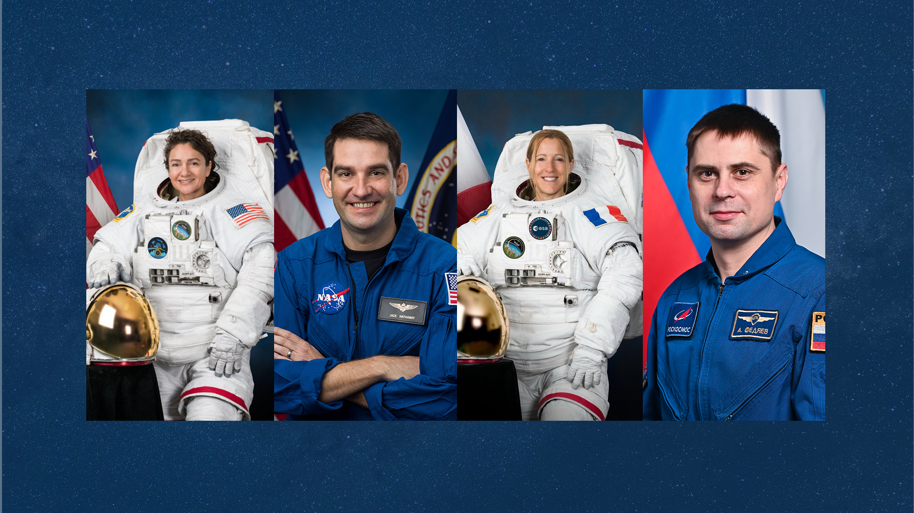
NASA, SpaceX Invite Media to Watch Crew-12 Launch to Space Station
Media accreditation is open for the launch of NASA’s 12th rotational mission of a SpaceX Falcon 9 rocket and Dragon spacecraft carrying astronauts to the International Space Station for a science expedition from Space Launch Complex 40 at Cape Canaveral Space Force Station in Florida.
NASA announced it is targeting no earlier than Thursday, Jan. 15, for a splashdown of its Crew-11 mission. The agency also is working with SpaceX and international partners to advance the launch of Crew-12, which is currently slated for Sunday, Feb. 15.
The crew includes NASA astronauts Jessica Meir, commander, Jack Hathaway, pilot; ESA (European Space Agency) astronaut Sophie Adenot, mission specialist; and Roscosmos cosmonaut Andrey Fedyaev, mission specialist. This will be the second spaceflight for Meir and Fedyaev, and the first for Hathaway and Adenot to the orbiting laboratory.
Media accreditation deadlines for the Crew-12 launch as part of NASA’s Commercial Crew Program are as follows:
- International media without U.S. citizenship must apply by 11:59 p.m. EST on Thursday, Jan. 15.
- U.S. media and U.S. citizens representing international media organizations must apply by 11:59 p.m. on Sunday, Jan. 18.
All accreditation requests must be submitted online at:
NASA’s media accreditation policy is online. For questions about accreditation or special logistical requests, email: ksc-media-accreditat@mail.nasa.gov. Requests for space for satellite trucks, tents, or electrical connections are due by Friday, Jan. 23.
For other questions, please contact NASA Kennedy’s newsroom at: 321-867-2468.
Para obtener información sobre cobertura en español en el Centro Espacial Kennedy o si desea solicitar entrevistas en español, comuníquese con Antonia Jaramillo: 321-501-8425, o Messod Bendayan: 256-930-1371.
For launch coverage and more information about the mission, visit:
https://www.nasa.gov/commercialcrew
-end-
Joshua Finch / Jimi Russell
Headquarters, Washington
202-358-1100
joshua.a.finch@nasa.gov / james.j.russell@nasa.gov
Steve Siceloff
Kennedy Space Center, Fla.
321-867-2468
steven.p.siceloff@nasa.gov
Joseph Zakrzewski
Johnson Space Center, Houston
281-483-5111
Joseph.a.zakrzewski@nasa.gov
