
Feed aggregator
Cattle used for cuddling therapy may prefer women over men
Cattle used for cuddling therapy may prefer women over men
Cows used for cuddling therapy may prefer women over men
This Start-Up Wants You to Put Custom Bacteria on Your Teeth
Lumina Probiotic has said a genetically modified microbe could prevent cavities. Experts, though, have safety concerns
How does spaceflight lead to medical breakthroughs? Veteran astronaut explains
ESA and the EU update their Security of Information Agreement
Keeping information secure in today’s interconnected world is becoming ever more important. ESA and the EU have amended their security of information agreement, reinforcing their trusted partnership.
Amateur astronomer finds 5 fascinating new galaxies — and they're now named after him
X-ray laser fires most powerful pulse ever recorded
X-ray laser fires most powerful pulse ever recorded
Havana Syndrome: We Don’t Need to Choose between Brain Injury and ‘Mass Hysteria’
Puzzling Havana Syndrome injuries that have afflicted U.S. diplomats may have a more complicated explanation than solely pulsed microwaves or mass psychology
Could Putting Neosporin in Your Nose Fend Off COVID?
People may someday have a surprisingly familiar tool to prevent viral infections: one of the antibiotics found in a common ointment
Solar eclipse 2024: Live updates
Euclid 'dark universe' telescope team will unveil new full-color images on May 23: How to watch live
Stellar telescope deal: Save $230 on the Celestron Astro Fi 130
LIVE LAUNCH: SPACEX NROL-146 MISSION
2024 Dream with Us Design Challenge Winners
3 min read
Preparations for Next Moonwalk Simulations Underway (and Underwater) Congratulations! Our 2024 Dream with Us challenge has concluded, and we are pleased to share the winning projects: Middle School 1st Place: The Unstoppable Changemakers Team (Anika J. and Aidan R.)
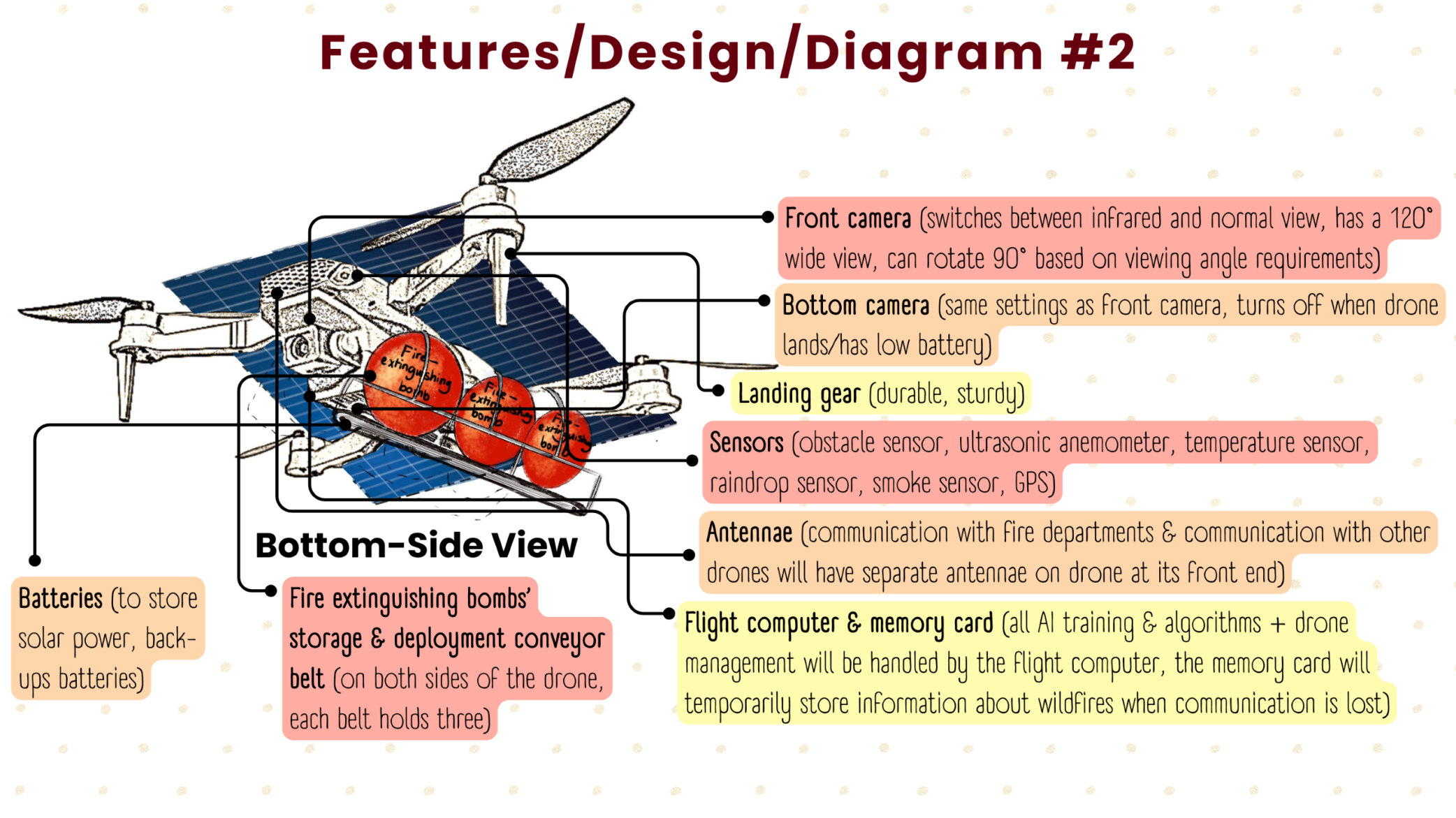
Fire Drones is a system of drones that battle wildfires. They use solar power for sustainability, machine learning technology for early detection of potential wildfires, and use biodegradable spheres called Fire Bombs to help extinguish wildfires. This system of firefighting drones actively communicates with emergency personnel to work until issues are marked “Resolved”.
2nd Place: Aerial Disaster Response Association Team (Adhavan B., Sanat N., Ganesh P., Carl S.)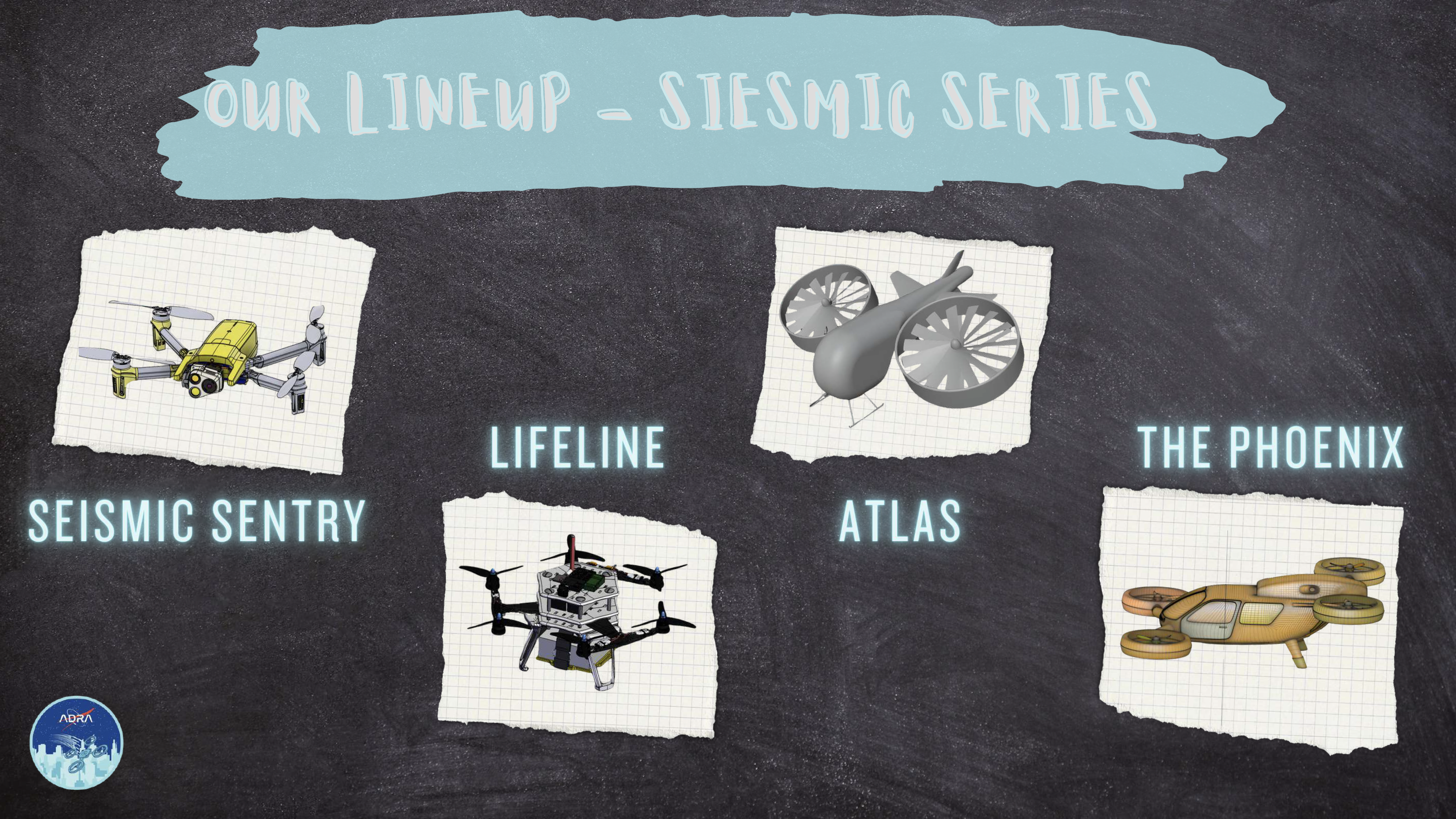
The Seismic Series is a drone system to assist with earthquake disasters. The Seismic Sentry, Lifeline, Atlas, and The Phoenix help to mitigate earthquake risks, save lives, and expedite recovery efforts. They detect problem areas, communicate with emergency personnel, civilians and other drones, deliver supplies, and one of them is large enough to carry up to 10 humans during an evacuation. Each drone has a different job, and they can also help in other disaster responses.
3rd Place: J.A.N.S. Team (Jason P., Aditya B., Nathan V., Sai Niranjan S.)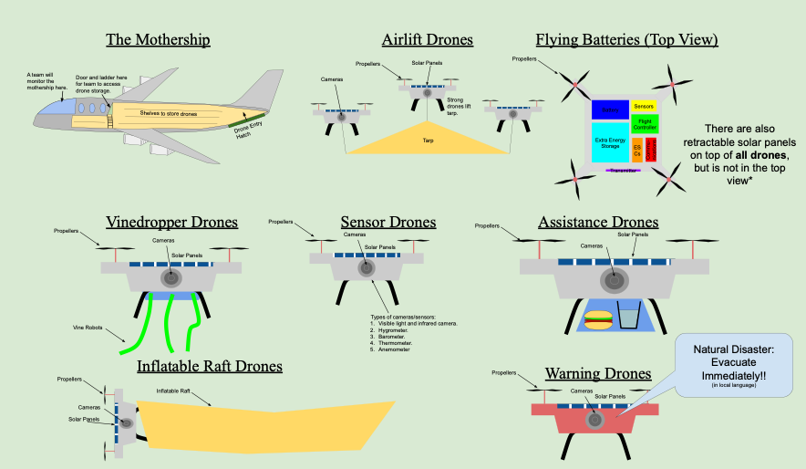
A drone system that uses several drones with different jobs to help during storm-type disasters. They are housed in a crewed mothership that helps to power and deploy the drones. The system includes airlift drones, flying battery drones, vine-dropper drones, assistance drones, sensor drones, inflatable raft drones, and warning drones. Each one is key in helping to monitor, warn, help, and save humans from storm catastrophe.
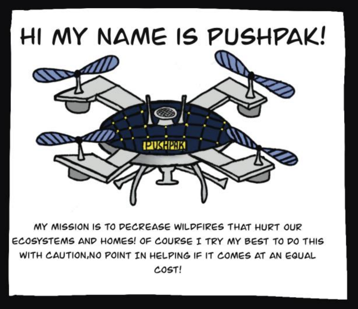
High School 1st Place: PUSHPAK Team (Devin W. and Isabel R.)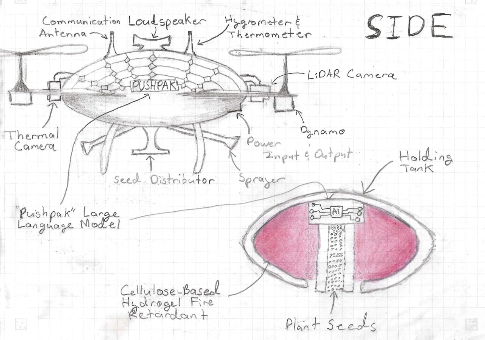
PushPak is a wildfire fighting drone. Thermal cameras detect hotspots and missing persons while the LiDAR camera maps the area, assesses the health of vegetation providing data for preventative and rebuilding efforts. It’s equipped with a holding tank that can be filled with extinguishing substances and fire retardant for prevention, planting seeds and a distributor for rebuilding after the wildfire. Solar-power recharges the drone when flying and the Dynamos (power-generating propellers) generate energy while flying. PushPak also has input/output capabilities to assist emergency personnel with powering needed devices. Variable wings allow this drone to be interchangeable, a comprehensive communication system lets it talk to humans and warn animals in the affected areas, plus a data collection system for early detection.
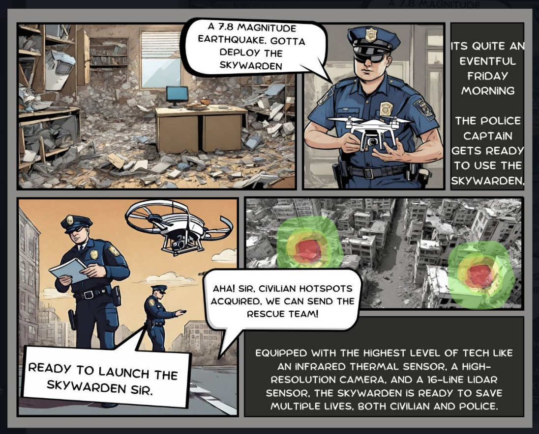
2nd Place: AirRescue Team (Sarthak K. and Advaith S.)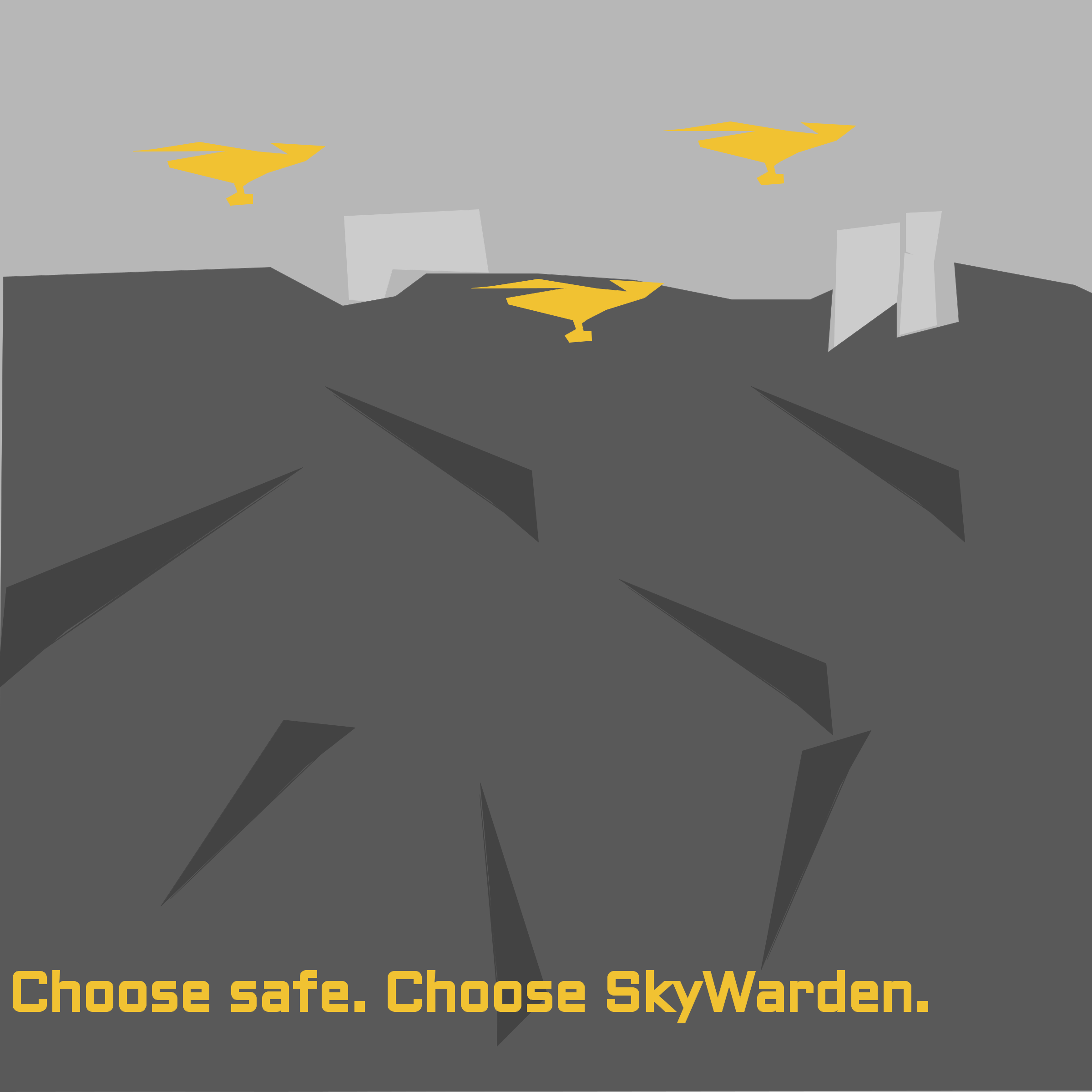
The SkyWarden is a drone that helps to preserve innocent lives during earthquake disasters. It uses LiDAR to create a digital map used to find safe routes and find people. Equipped with a thermal sensor, it can locate life under the rubble and send information to emergency personnel. Its computer vision could recognize faces, bones, and blood to find human-life.
3rd Place: Flight Fusion Team (Emily A. and Zahraa A.)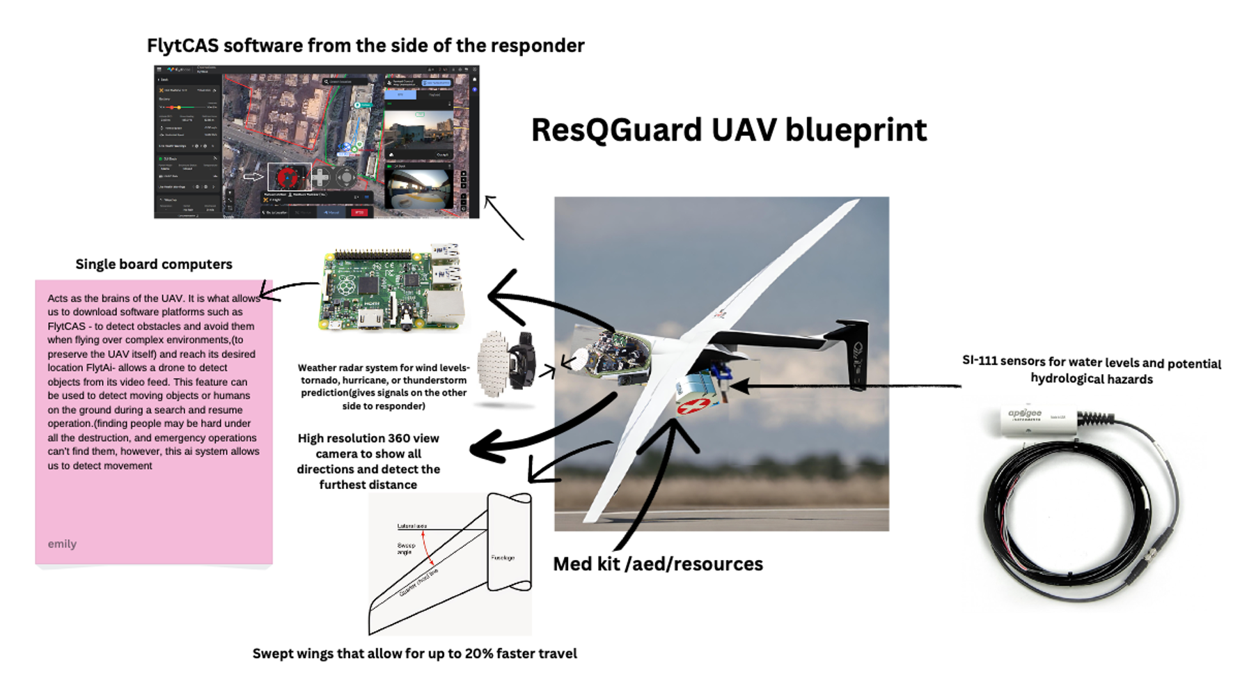
ResQGuard is an enhanced UAV that helps during severe weather such as thunderstorms, hurricanes and tornadoes and hydrological disasters such as floods, tsunamis, and drought. It has a swept wing design for 20% faster travel, weather radar system, sensors for hydro hazards, single-board computers, an essential medical kit, a camera with a 360 view, and fast processing software.
Facebook logo @NASA@NASAaero@NASA_es @NASA@NASAaero@NASA_es Instagram logo @NASA@NASAaero@NASA_es Linkedin logo @NASA Explore More 3 min read System-Wide Safety Collaborations Article 2 days ago 4 min read NASA, Industry to Start Designing More Sustainable Jet Engine Core Article 5 days ago 4 min read Aviary: A New NASA Software Platform for Aircraft Modelling Article 6 days ago Keep Exploring Discover More Topics From NASAMissions
Humans In Space
Aeronautics STEM
Explore NASA’s History
Share Details Last Updated May 22, 2024 EditorLillian GipsonContactJim Bankejim.banke@nasa.gov Related TermsSpace Force orders 'jetpack' to give 2 years of maneuverability to military satellite
Dream Chaser space plane arrives in Florida ahead of 1st launch to ISS (photo)
Phoenix, America’s Hottest City, Is Having a Surge of Deaths
Skyrocketing temperatures are colliding with a lack of planning in Phoenix that is contributing to a rise in heat-related deaths
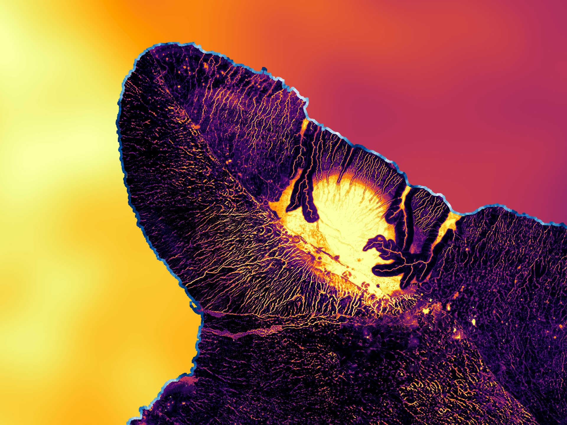
Modeling the Hawaiian Shoreline
The island of Hawai’i and surrounding waters glow in unusual shades in this 2022 model made through NASA DEVELOP. The model was created to help the County of Hawai’i in their shoreline setback plan. The image shows areas of high flood risk (blue), as well as sea surface temperatures. Orange in the west indicates high temperatures, while red in the east represents low temperatures.
NASA DEVELOP projects bridge the gap between NASA’s Earth science data and society, addressing environmental concerns and enhancing decision-making to improve life here on Earth. Learn more about NASA’s Capacity Building Programs and applied Earth science at NASA.
Image Credit: NASA/Lisa Tanh, Matilda Anokye, Ian Lee, Connor Racette