
Feed aggregator
What is AI? (Grades 5-8)
This article is for students grades 5-8.
What is AI?Artificial intelligence, or AI, is a type of technology that helps machines and computers have “thinking” abilities similar to humans. Devices using AI can learn words and concepts, recognize objects, see patterns, or make predictions. They can also be taught how to work autonomously. AI is often used to help people understand and solve problems more quickly than they could on their own.
AI includes:
- Machine learning: This type of AI looks at large amounts of data and learns how to make fast and accurate predictions based on that data.
- Deep learning: This type helps computers operate much like the human brain. It uses several layers of “thought” to recognize patterns and learn new information. Deep learning is a type of machine learning.
- Generative AI: A human can use generative AI to create text, videos, images, and more. It is based on deep learning.
NASA has found uses for AI in many of its missions and programs.
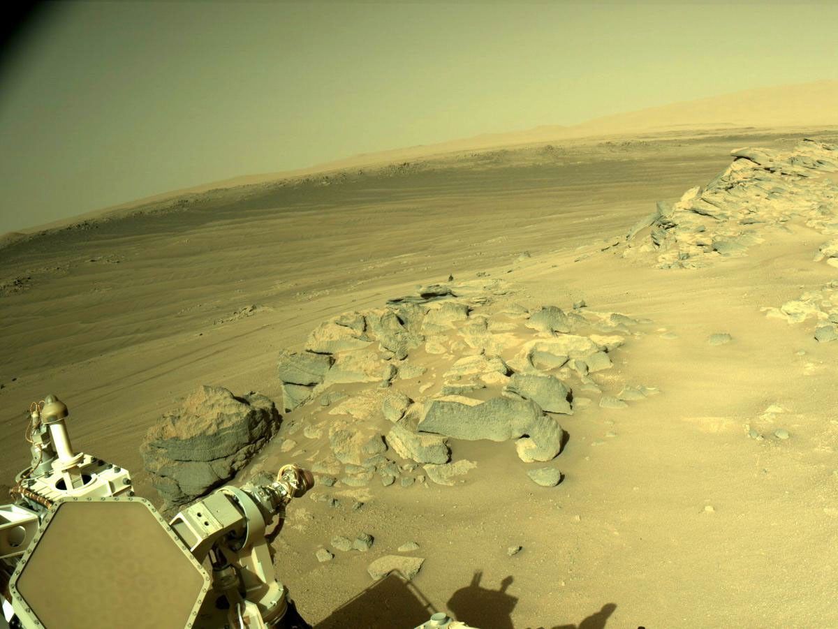
For missions to the Moon, AI can use satellite imagery to create detailed 3D maps of dark craters. This data could help scientists plan missions, spot hazards, and even identify where future crews might find water ice. On Mars, the Perseverance rover uses AI to drive itself autonomously. It takes pictures of the ground, sees obstacles, and chooses the safest path.
AI also helps NASA search for planets outside our solar system. For example, AI has helped citizen scientists find over 10,000 pairs of binary stars. These pairs orbit each other and block each other’s light. This information could help scientists search for new planets and learn more about how stars form.
———————————————————————————————
Words to KnowAutonomous: acting or operating independently, without external control. An autonomous technology can perform duties without human intervention.
Citizen scientist: a member of the public, often a volunteer, who collects data that can be used by scientists. When members of the public participate in research in this way, it’s called citizen science.
———————————————————————————————
NASA also uses AI to support its work on Earth. The agency uses AI to aid disaster relief efforts during and after natural disasters like hurricanes or wildfires. For example, AI can count tarps on roofs in satellite images to measure damage after a storm. NASA is also supporting flight controllers and pilots by using AI to plan better flight routes, making air travel safer and more efficient.
AI is helping NASA explore space, protect people, and make amazing discoveries!
The blue tentacle-like arms containing gecko-like adhesive pads, attaBlue tentacle-like arms with gecko-like adhesive pads reach out and grapple a “capture cube” inside the International Space Station. The arms are attached to the cube-shaped Astrobee robotic free-flyer, right. The experimental grippers demonstrated techniques to autonomously perform tasks in low Earth orbit.NASA Advice From NASA AI Experts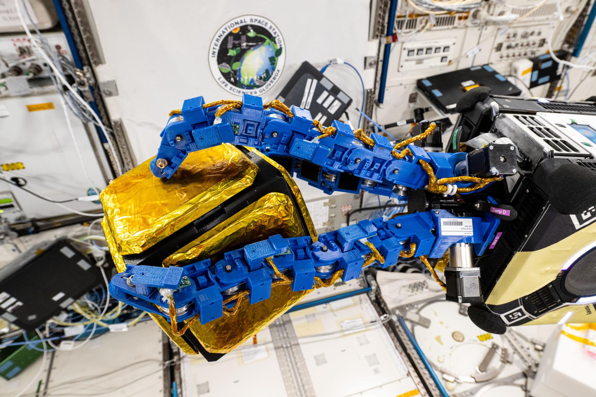
“AI is a great field for people who like solving problems, building things, or asking questions about how the world works. People use AI to help doctors understand diseases, to teach robots how to explore space, and to help communities prepare for things like floods or wildfires. If you like using technology to help people and discover new things, AI could be a great career for you!” – Krista Kinnard, NASA’s Deputy Chief AI Officer
In this illustration, astronauts work on the lunar surface as part of NASA’s Artemis program.NASA Career Corner
NASA roles that may involve AI include:
Astronauts: Astronauts on the International Space Station can use an AI “digital assistant” to get medical recommendations. This is helpful when communication with Earth is interrupted. It could also be useful on future missions to distant destinations like Mars.
Engineers: Engineers can use AI to help them generate designs for things like new spacecraft.
Astronomers: AI helps astronomers analyze satellite and deep space telescope data to find stars and exoplanets.
Meteorologists: Weather experts can use machine learning to make climate projections.
Programmers: Programmers can use AI to update code used in older missions, bringing it up to modern standards.
IT professionals: AI can enable IT experts to understand outages across NASA, allowing them to get programs back up and running faster.
Program managers: Program managers can use AI to plan and model NASA missions.
Build Your Computer Science Skills With NASA
Gaining Traction on Mars Activity
NASA Space Detective: Can You Spot a Star or a Galaxy
Video: Hack Into Computer Science With NASA
Artificial Intelligence at NASA
What would Russia's inability to launch crewed missions mean for ISS?
What would Russia's inability to launch crewed missions mean for ISS?
Coral reefs have fuelled severe global warming in Earth's past
Coral reefs have fuelled severe global warming in Earth's past
We now have a greater understanding of how exercise slows cancer
We now have a greater understanding of how exercise slows cancer
The life-giving secret of protoplanetary disks? Dust.
The complex molecules required for life on Earth might never have formed if it wasn’t for cosmic dust.
ByteDance Launches Doubao Real-Time AI Voice Assistant for Phones
The company behind TikTok is rolling out a smartphone AI assistant that behaves less like an app and more like a secretary
The Universe Was Warm Before It Was Bright
There is a period in the Universe known as the cosmic dark ages. It lies between the recombination of the first atoms and the ignition of the first stars, when the Universe was thought to be cold and dark. Now astronomers have looked at the faint glow of atomic hydrogen to find that while the Universe was dark, it wasn't quite as cold as we thought.
Sagittarius B2 Molecular Cloud
Sagittarius B2 Molecular Cloud
The Mid-Infrared Instrument (MIRI) on NASA’s James Webb Space Telescope captured glowing cosmic dust heated by very young massive stars in unprecedented detail in this image of the Sagittarius B2 (Sgr B2) molecular cloud released on Sept. 24, 2025.
Sgr B2 is the most massive, and active star-forming region in our galaxy, located only a few hundred light years from our central supermassive black hole. While Sgr B2 has only 10% of the galactic center’s gas, it produces 50% of its stars. Astronomers want to figure out why it is so much more active than the rest of the galactic center.
MIRI has both a camera and a spectrograph that sees light in the mid-infrared region of the electromagnetic spectrum. MIRI’s view reveals colorful stars punctuated occasionally by bright clouds of gas and dust. Further research into these stars will reveal details of their masses and ages, which will help astronomers better understand the process of star formation in this dense, active galactic center region.
Image credit: Image: NASA, ESA, CSA, STScI, Adam Ginsburg (University of Florida), Nazar Budaiev (University of Florida), Taehwa Yoo (University of Florida); Image Processing: Alyssa Pagan (STScI)