
Feed aggregator
Massive Stars Make Their Mark in Hubble Image
This NASA/ESA Hubble Space Telescope image features a glittering blue dwarf galaxy called Markarian 178 (Mrk 178). The galaxy, which is substantially smaller than our own Milky Way, lies 13 million light-years away in the constellation Ursa Major (the Great Bear).
Mrk 178 is one of more than 1,500 Markarian galaxies. These galaxies get their name from the Armenian astrophysicist Benjamin Markarian, who compiled a list of galaxies that were surprisingly bright in ultraviolet light.
While the bulk of the galaxy is blue due to an abundance of young, hot stars with little dust shrouding them, Mrk 178 gets a red hue from a collection of rare massive Wolf–Rayet stars. These stars are concentrated in the brightest, reddish region near the galaxy’s edge. Wolf–Rayet stars cast off their atmospheres through powerful winds, and the bright emission lines from their hot stellar winds are etched upon the galaxy’s spectrum. Both ionized hydrogen and oxygen lines are particularly strong and appear as a red color in this photo.
Massive stars enter the Wolf–Rayet phase of their evolution just before they collapse into black holes or neutron stars. Because Wolf–Rayet stars last for only a few million years, researchers know that something must have triggered a recent burst of star formation in Mrk 178. At first glance, it’s not clear what could be the cause — Mrk 178 doesn’t seem to have any close galactic neighbors that may have stirred up its gas to form new stars. Instead, researchers suspect that a gas cloud crashed into Mrk 178, or that the intergalactic medium disturbed its gas as the galaxy moved through space. Either disturbance could light up this tiny galaxy with a ripple of bright new stars.
Image credit: ESA/Hubble & NASA, F. Annibali, S. Hong
NASA’s Two-in-One Satellite Propulsion Demo Begins In-Space Test
2 min read
Preparations for Next Moonwalk Simulations Underway (and Underwater) Dual Propulsion Experiment (DUPLEX) deploys from the International Space Station December 2, 2025.NASANASA is working with commercial partners to create high-performing, reliable propulsion systems that will help small spacecraft safely maneuver in orbit, reach intended destinations across the solar system, and accomplish mission operations.
Two new micropropulsion technologies are being tested in space onboard a CubeSat called DUPLEX (Dual Propulsion Experiment) that deployed into low Earth orbit from the International Space Station on Dec. 2. The CubeSat is fitted with two thruster systems that use spools of polymer fibers to provide performance levels of propulsion comparable to existing systems but with greater safety during assembly and more affordability.
One of the propulsion technologies is a fiber-fed pulsed plasma thruster system which employs an electric pulse to vaporize Teflon material and uses the resulting ions to deliver strong, efficient thrust while using very little fuel. The other propulsion technology is a monofilament vaporization propulsion system – inspired by 3D printers – which heats and vaporizes a common polymer material known as Delrin to create continuous thrust.
On orbit, DUPLEX will test its advanced propulsion systems by raising and lowering its orbit over two years, demonstrating the systems’ capabilities to maintain a vehicle’s orbit over time. Micropropulsion solutions enable a variety of cost-efficient capabilities necessary for operators in a bustling low Earth orbit economy, including maintaining and adjusting orbits to avoid debris or nearby spacecraft, and coordinating maneuvers between spacecraft to perform maintenance, inspections, and other critical activities. The systems tested on DUPLEX can also make spacecraft capable of lower cost extended missions in areas that are farther from Earth, such as the Moon and Mars.
Technologies like those demonstrated onboard DUPLEX open the door for U.S. industry to provide efficient, affordable spacecraft systems for various space-based applications, building a stronger orbital economy to meet the needs of NASA and the nation.
The DUPLEX spacecraft was developed by Champaign-Urbana Aerospace in Illinois. NASA’s Small Spacecraft and Distributed Systems program at the agency’s Ames Research Center in California’s Silicon Valley supported the development, with funding from the Small Business Innovation Research program and a 2019 Tipping Point industry partnership award through the agency’s Space Technology Mission Directorate.
Share Details Last Updated Dec 17, 2025 Related Terms Explore More 2 min read NASA Launches Research Program for Students to Explore Big Ideas Article 1 day ago 7 min read Through Astronaut Eyes: 25 Years of Life in Orbit Article 1 day ago 1 min read NASA ORBIT Challenge 2026 Article 1 day ago Keep Exploring Discover More Topics From NASAMissions
Humans in Space
Climate Change
Solar System
NASA’s Two-in-One Satellite Propulsion Demo Begins In-Space Test
2 min read
Preparations for Next Moonwalk Simulations Underway (and Underwater) Dual Propulsion Experiment (DUPLEX) deploys from the International Space Station December 2, 2025.NASANASA is working with commercial partners to create high-performing, reliable propulsion systems that will help small spacecraft safely maneuver in orbit, reach intended destinations across the solar system, and accomplish mission operations.
Two new micropropulsion technologies are being tested in space onboard a CubeSat called DUPLEX (Dual Propulsion Experiment) that deployed into low Earth orbit from the International Space Station on Dec. 2. The CubeSat is fitted with two thruster systems that use spools of polymer fibers to provide performance levels of propulsion comparable to existing systems but with greater safety during assembly and more affordability.
One of the propulsion technologies is a fiber-fed pulsed plasma thruster system which employs an electric pulse to vaporize Teflon material and uses the resulting ions to deliver strong, efficient thrust while using very little fuel. The other propulsion technology is a monofilament vaporization propulsion system – inspired by 3D printers – which heats and vaporizes a common polymer material known as Delrin to create continuous thrust.
On orbit, DUPLEX will test its advanced propulsion systems by raising and lowering its orbit over two years, demonstrating the systems’ capabilities to maintain a vehicle’s orbit over time. Micropropulsion solutions enable a variety of cost-efficient capabilities necessary for operators in a bustling low Earth orbit economy, including maintaining and adjusting orbits to avoid debris or nearby spacecraft, and coordinating maneuvers between spacecraft to perform maintenance, inspections, and other critical activities. The systems tested on DUPLEX can also make spacecraft capable of lower cost extended missions in areas that are farther from Earth, such as the Moon and Mars.
Technologies like those demonstrated onboard DUPLEX open the door for U.S. industry to provide efficient, affordable spacecraft systems for various space-based applications, building a stronger orbital economy to meet the needs of NASA and the nation.
The DUPLEX spacecraft was developed by Champaign-Urbana Aerospace in Illinois. NASA’s Small Spacecraft and Distributed Systems program at the agency’s Ames Research Center in California’s Silicon Valley supported the development, with funding from the Small Business Innovation Research program and a 2019 Tipping Point industry partnership award through the agency’s Space Technology Mission Directorate.
Share Details Last Updated Dec 17, 2025 Related Terms Explore More 2 min read NASA Launches Research Program for Students to Explore Big Ideas Article 1 day ago 7 min read Through Astronaut Eyes: 25 Years of Life in Orbit Article 1 day ago 1 min read NASA ORBIT Challenge 2026 Article 2 days ago Keep Exploring Discover More Topics From NASAMissions
Humans in Space
Climate Change
Solar System
Strange lemon-shaped exoplanet defies the rules of planet formation
Strange lemon-shaped exoplanet defies the rules of planet formation
Comet 3I/ATLAS Has A Green Glow In New Color Images From Gemini North
Gemini North captured new images of Comet 3I/ATLAS after it reemerged from behind the Sun on its path out of the Solar System. The data were collected during a Shadow the Scientists session — a unique outreach initiative that invites students around the world to join researchers as they observe the Universe on the world’s most advanced telescopes.
NASA’s Push Toward Commercial Space Communications Gains Momentum
NASA’s commercial partners are actively demonstrating next-generation satellite relay capabilities for spaceflight missions, marking a significant step toward retiring the agency’s Tracking and Data Relay Satellite (TDRS) system and adopting commercial services. The demonstrations – ranging from real-time spacecraft tracking during launch to transmitting mission commands and scientific data – are part of NASA’s Communications Services Project, which is modernizing how the agency communicates with its science missions in near-Earth orbit.
Managed by the agency’s SCaN (Space Communications and Navigation) Program, the project awarded funded Space Act Agreements in 2022 to six U.S. companies that are developing and testing commercial satellite communications services. The initiative supports NASA’s broader strategy to retire the TDRS constellation and adopt a commercial-first model for near-Earth communications.
“In collaboration with our commercial partners, SCaN is ushering in a new era of space exploration that will deliver powerful, forward-thinking solutions that reduce cost, increase adaptability, and increase mission success,” said Kevin Coggins, deputy associate administrator for SCaN at NASA Headquarters in Washington. “This work advances our commitment to expanding the low Earth orbit economy, and our commercial space partners are leading the charge through these groundbreaking demonstrations, proving for the first time that commercial satellite relay services can work for NASA missions.”
This work advances our commitment to expanding the low Earth orbit economy, and our commercial space partners are leading the charge through these groundbreaking demonstrations.Kevin Coggins
Deputy Associate Administrator for SCaN
By leveraging private-sector innovation, NASA aims to establish a more flexible, cost-effective, and scalable communications infrastructure for future science missions.
AmazonAmazon Leo for Government, a subsidiary of Amazon, is demonstrating high-rate data exchanges over optical links using its satellite network in low Earth orbit
Amazon has developed the hardware and software components necessary to support optical communication links within its Amazon Leo satellite relay network. Optical communications, also known as laser communications, use infrared light to transmit data at a higher rate compared to standard radio frequency systems. The Amazon Leo demonstrations, scheduled to begin in early 2026, will test the pointing, acquisition, and tracking capabilities of their optical communications systems to ensure the technology can accurately locate, lock onto, and stay connected with a mission as it travels through space.
An image of the view from an Amazon Leo satellite overlooking the Earth. Credit: Amazon SES Space & DefenseSES Space & Defense is demonstrating high-rate data exchanges as well as tracking, telemetry, and command services using its O3b mPOWER satellite network in medium Earth orbit and its satellites in geosynchronous Earth orbit.
Over the last two months, in collaboration with Planet Labs, SES conducted multiple flight tests of its near-Earth space relay services. These demonstrations showcased uninterrupted, high-capacity connectivity between a Planet Labs satellite in low Earth orbit and SES communications satellites in geosynchronous Earth orbit and medium Earth orbit, demonstrating the ability to deliver real-time data relay across multiple orbits. SES has validated two relay services, one for low-rate tracking, telemetry, and command applications via its C-band satellites, and one for high-rate data applications over its Ka-band constellation. Additional flight demonstrations are planned for early 2026.
An artist’s concept of SES Space and Defense’s satellite relay demonstration.Credit: SES Space and Defense SpaceX
SpaceX is demonstrating high-rate data exchanges over optical links using its Starlink network in low Earth orbit.
Since 2024, SpaceX has completed multiple demonstrations of on-orbit optical communications services. During two human spaceflight missions, Polaris Dawn and Fram2, SpaceX leveraged the Starlink satellite constellation and an optical communications terminal installed on the Dragon spacecraft to demonstrate high-rate data relay services. Optical communications technology is not currently available through TDRS. By demonstrating optical relay services with multiple commercial partners, the agency is unlocking new capabilities for emerging missions.
An artist’s concept of SpaceX’s commercial satellite relay demonstration using the Dragon spacecraft and Starlink network.Credit: SpaceX Telesat
Telesat U.S. Services LLC, doing business as Telesat Government Solutions, is demonstrating high-rate data exchanges over optical links using its anticipated Telesat Lightspeed network in low Earth orbit.
Development of the Telesat Lightspeed satellite network is currently underway, with satellite launches planned for late 2026. These satellites will use innovative technologies, like optical inter-satellite links and advanced onboard processing, to establish a global, mesh network in space. Software-defined networks aim to enable robust and reliable routing of traffic from a space-based or terrestrial terminal to its final destination autonomously. In 2027, Telesat plans to complete multiple demonstrations of space-to-space connectivity, including an optical data exchange from a Planet Labs spacecraft in low Earth orbit to the Telesat Lightspeed constellation. The data will then be routed over optical links before getting downlinked to a Telesat landing station on Earth, representing a full end-to-end capability.
An artist illustration of Telesat’s planned commercial relay demonstration using its Lightspeed satellite network. Credit: Telesat ViasatViasat Inc. is demonstrating launch, tracking, telemetry, command, and high-data rate exchanges for launch vehicles and low Earth orbit operations. In May 2023, Viasat completed the acquisition of Inmarsat, the sixth satellite communications company to win a contract award from NASA, combining the resources of both companies to form a unified global communications provider.
Viasat’s space demonstrations will use its established satellite networks in geostationary orbit to validate three primary capabilities: launch telemetry over the L-band radio frequency to track and monitor spacecraft during ascent; command and control over L-band to maintain continuous spacecraft custody and enable real-time operations; and high-speed Ka-band data relay to transfer large volumes of mission data through next-generation spacecraft terminals. Flights test began in November, when Viasat used its satellite network to successfully track the telemetry of Blue Origin’s New Glenn rocket as it launched into low Earth orbit. Follow-on demonstrations are planned for 2026, including additional L-band launch services as well as high-capacity services over Ka-band frequencies.
An artist’s concept outlining Viasat’s satellite relay capabilities.Credit: Viasat
Commercializing communications services for future near-Earth science missions enables NASA to focus resources on deep space missions to the Moon as part of the Artemis campaign, in preparation for future human missions to Mars. The agency will continue to work with these commercial partners to demonstrate next-generation services through 2027. By 2031, NASA plans to purchase satellite relay services for science missions from one or more U.S. satellite communications providers.
To learn more about the decision to use commercial satellite relay services in low Earth orbit, visit:
Embracing Commercial Relay Services – NASA
The Communications Services Project is managed by NASA’s Glenn Research Center in Cleveland, under the direction of the Space Communications and Navigation Program within NASA’s Space Operations Mission Directorate.
Share Details Last Updated Dec 17, 2025 Related Terms Keep Exploring Discover More Topics From NASACommunicating with Missions
Communications Services Project
Commercial Space
Commercializing Space Communications
NASA Study Suggests Saturn’s Moon Titan May Not Have Global Ocean
6 min read
Preparations for Next Moonwalk Simulations Underway (and Underwater) This artist’s concept depicts NASA’s Cassini spacecraft performing one of its many close flybys of Titan, Saturn’s largest moon. By analyzing the Doppler shift of radio signals traveling to and from Earth, the mission precisely measured Titan’s gravity field.NASA/JPL-CaltechA key discovery from NASA’s Cassini mission in 2008 was that Saturn’s largest moon Titan may have a vast water ocean below its hydrocarbon-rich surface. But reanalysis of mission data suggests a more complicated picture: Titan’s interior is more likely composed of ice, with layers of slush and small pockets of warm water that form near its rocky core.
Led by researchers at NASA’s Jet Propulsion Laboratory in Southern California and published in the journal Nature on Wednesday, the new study could have implications for scientists’ understanding of Titan and other icy moons throughout our solar system.
“This research underscores the power of archival planetary science data. It is important to remember that the data these amazing spacecraft collect lives on so discoveries can be made years, or even decades, later as analysis techniques get more sophisticated,” said Julie Castillo-Rogez, senior research scientist at JPL and a coauthor of the study. “It’s the gift that keeps giving.”
To remotely probe planets, moons, and asteroids, scientists study the radio frequency communications traveling back and forth between spacecraft and NASA’s Deep Space Network. It’s a multilayered process. Because a moon’s body may not have a uniform distribution of mass, its gravity field will change as a spacecraft flies through it, causing the spacecraft to speed up or slow down slightly. In turn, these variations in speed alter the frequency of the radio waves going to and from the spacecraft — an effect known as Doppler shift. Analyzing the Doppler shift can lend insight into a moon’s gravity field and its shape, which can change over time as it orbits within its parent planet’s gravitational pull.
This shape shifting is called tidal flexing. In Titan’s case, Saturn’s immense gravitational field squeezes the moon when Titan is closer to the planet during its slightly elliptical orbit, and it stretches the moon when it is farthest. Such flexing creates energy that is lost, or dissipated, in the form of internal heating.
When mission scientists analyzed radio-frequency data gathered during the now-retired Cassini mission’s 10 close approaches of Titan, they found the moon to be flexing so much that they concluded it must have a liquid interior, since a solid interior would have flexed far less. (Think of a balloon filled with water versus a billiard ball.)
New techniqueThe new research highlights another possible explanation for this malleability: an interior composed of layers featuring a mix of ice and water that allows the moon to flex. In this scenario, there would be a lag of several hours between Saturn’s tidal pull and when the moon shows signs of flexing — much slower than if the interior were fully liquid. A slushy interior would also exhibit a stronger energy dissipation signature in the moon’s gravity field than a liquid one, because these slush layers would generate friction and produce heat when the ice crystals rub against one another. But there was nothing apparent in the data to suggest this was happening.
So the study authors, led by JPL postdoctoral researcher Flavio Petricca, looked more closely at the Doppler data to see why. By applying a novel processing technique, they reduced the noise in the data. What emerged was a signature that revealed strong energy loss deep inside Titan. The researchers interpreted this signature to be coming from layers of slush, overlaid by a thick shell of solid ice.
Based on this new model of Titan’s interior, the researchers suggest that the only liquid would be in the form of pockets of meltwater. Heated by dissipating tidal energy, the water pockets slowly travel toward the frozen layers of ice at the surface. As they rise, they have the potential to create unique environments enriched by organic molecules being supplied from below and from material delivered via meteorite impacts on the surface.
“Nobody was expecting very strong energy dissipation inside Titan. But by reducing the noise in the Doppler data, we could see these smaller wiggles emerge. That was the smoking gun that indicates Titan’s interior is different from what was inferred from previous analyses,” said Petricca. “The low viscosity of the slush still allows the moon to bulge and compress in response to Saturn’s tides, and to remove the heat that would otherwise melt the ice and form an ocean.”
Potential for life“While Titan may not possess a global ocean, that doesn’t preclude its potential for harboring basic life forms, assuming life could form on Titan. In fact, I think it makes Titan more interesting,” Petricca added. “Our analysis shows there should be pockets of liquid water, possibly as warm as 20 degrees Celsius (68 degrees Fahrenheit), cycling nutrients from the moon’s rocky core through slushy layers of high-pressure ice to a solid icy shell at the surface.”
More definitive information could come from NASA’s next mission to Saturn. Launching no earlier than 2028, the agency’s Dragonfly mission to the hazy moon could provide the ground truth. The first-of-its-kind rotorcraft will explore Titan’s surface to investigate the moon’s habitability. Carrying a seismometer, the mission may provide key measurements to probe Titan’s interior, depending on what seismic events occur while it is on the surface.
More about CassiniThe Cassini-Huygens mission was a cooperative project of NASA, ESA (European Space Agency), and the Italian Space Agency. A division of Caltech in Pasadena, JPL managed the mission for NASA’s Space Mission Directorate in Washington and designed, developed, and assembled the Cassini orbiter.
To learn more about NASA’s Cassini mission, visit:
https://science.nasa.gov/mission/cassini/
News Media Contacts
Ian J. O’Neill
Jet Propulsion Laboratory, Pasadena, Calif.
818-354-2649
ian.j.oneill@jpl.nasa.gov
Karen Fox / Alana Johnson
NASA Headquarters, Washington
202-358-1600 / 202-358-1501
karen.c.fox@nasa.gov / alana.r.johnson@nasa.gov
2025-142
Share Details Last Updated Dec 17, 2025 Related Terms Explore More 6 min read NASA’s Perseverance Mars Rover Ready to Roll for Miles in Years Ahead Article 10 hours ago 6 min read NASA JPL Shakes Things Up Testing Future Commercial Lunar Spacecraft Article 1 day ago 3 min read One of NASA’s Key Cameras Orbiting Mars Takes 100,000th Image Article 2 days ago Keep Exploring Discover Related Topics TitanOverview: Cassini at Titan Until the Cassini mission, little was known about Saturn’s largest moon Titan, save that it was…
DragonflyDragonfly, the first-of-its-kind rotorcraft to explore another world, will fly to various locations on Saturn’s moon Titan to investigate the…
Ocean Worlds ResourcesThis page showcases our curated resources for those interested in learning more about ocean worlds.
Cassini-HuygensSaturn Orbiter
NASA Study Suggests Saturn’s Moon Titan May Not Have Global Ocean
6 min read
Preparations for Next Moonwalk Simulations Underway (and Underwater) This artist’s concept depicts NASA’s Cassini spacecraft performing one of its many close flybys of Titan, Saturn’s largest moon. By analyzing the Doppler shift of radio signals traveling to and from Earth, the mission precisely measured Titan’s gravity field.NASA/JPL-CaltechA key discovery from NASA’s Cassini mission in 2008 was that Saturn’s largest moon Titan may have a vast water ocean below its hydrocarbon-rich surface. But reanalysis of mission data suggests a more complicated picture: Titan’s interior is more likely composed of ice, with layers of slush and small pockets of warm water that form near its rocky core.
Led by researchers at NASA’s Jet Propulsion Laboratory in Southern California and published in the journal Nature on Wednesday, the new study could have implications for scientists’ understanding of Titan and other icy moons throughout our solar system.
“This research underscores the power of archival planetary science data. It is important to remember that the data these amazing spacecraft collect lives on so discoveries can be made years, or even decades, later as analysis techniques get more sophisticated,” said Julie Castillo-Rogez, senior research scientist at JPL and a coauthor of the study. “It’s the gift that keeps giving.”
To remotely probe planets, moons, and asteroids, scientists study the radio frequency communications traveling back and forth between spacecraft and NASA’s Deep Space Network. It’s a multilayered process. Because a moon’s body may not have a uniform distribution of mass, its gravity field will change as a spacecraft flies through it, causing the spacecraft to speed up or slow down slightly. In turn, these variations in speed alter the frequency of the radio waves going to and from the spacecraft — an effect known as Doppler shift. Analyzing the Doppler shift can lend insight into a moon’s gravity field and its shape, which can change over time as it orbits within its parent planet’s gravitational pull.
This shape shifting is called tidal flexing. In Titan’s case, Saturn’s immense gravitational field squeezes the moon when Titan is closer to the planet during its slightly elliptical orbit, and it stretches the moon when it is farthest. Such flexing creates energy that is lost, or dissipated, in the form of internal heating.
When mission scientists analyzed radio-frequency data gathered during the now-retired Cassini mission’s 10 close approaches of Titan, they found the moon to be flexing so much that they concluded it must have a liquid interior, since a solid interior would have flexed far less. (Think of a balloon filled with water versus a billiard ball.)
New techniqueThe new research highlights another possible explanation for this malleability: an interior composed of layers featuring a mix of ice and water that allows the moon to flex. In this scenario, there would be a lag of several hours between Saturn’s tidal pull and when the moon shows signs of flexing — much slower than if the interior were fully liquid. A slushy interior would also exhibit a stronger energy dissipation signature in the moon’s gravity field than a liquid one, because these slush layers would generate friction and produce heat when the ice crystals rub against one another. But there was nothing apparent in the data to suggest this was happening.
So the study authors, led by JPL postdoctoral researcher Flavio Petricca, looked more closely at the Doppler data to see why. By applying a novel processing technique, they reduced the noise in the data. What emerged was a signature that revealed strong energy loss deep inside Titan. The researchers interpreted this signature to be coming from layers of slush, overlaid by a thick shell of solid ice.
Based on this new model of Titan’s interior, the researchers suggest that the only liquid would be in the form of pockets of meltwater. Heated by dissipating tidal energy, the water pockets slowly travel toward the frozen layers of ice at the surface. As they rise, they have the potential to create unique environments enriched by organic molecules being supplied from below and from material delivered via meteorite impacts on the surface.
“Nobody was expecting very strong energy dissipation inside Titan. But by reducing the noise in the Doppler data, we could see these smaller wiggles emerge. That was the smoking gun that indicates Titan’s interior is different from what was inferred from previous analyses,” said Petricca. “The low viscosity of the slush still allows the moon to bulge and compress in response to Saturn’s tides, and to remove the heat that would otherwise melt the ice and form an ocean.”
Potential for life“While Titan may not possess a global ocean, that doesn’t preclude its potential for harboring basic life forms, assuming life could form on Titan. In fact, I think it makes Titan more interesting,” Petricca added. “Our analysis shows there should be pockets of liquid water, possibly as warm as 20 degrees Celsius (68 degrees Fahrenheit), cycling nutrients from the moon’s rocky core through slushy layers of high-pressure ice to a solid icy shell at the surface.”
More definitive information could come from NASA’s next mission to Saturn. Launching no earlier than 2028, the agency’s Dragonfly mission to the hazy moon could provide the ground truth. The first-of-its-kind rotorcraft will explore Titan’s surface to investigate the moon’s habitability. Carrying a seismometer, the mission may provide key measurements to probe Titan’s interior, depending on what seismic events occur while it is on the surface.
More about CassiniThe Cassini-Huygens mission was a cooperative project of NASA, ESA (European Space Agency), and the Italian Space Agency. A division of Caltech in Pasadena, JPL managed the mission for NASA’s Space Mission Directorate in Washington and designed, developed, and assembled the Cassini orbiter.
To learn more about NASA’s Cassini mission, visit:
https://science.nasa.gov/mission/cassini/
News Media Contacts
Ian J. O’Neill
Jet Propulsion Laboratory, Pasadena, Calif.
818-354-2649
ian.j.oneill@jpl.nasa.gov
Karen Fox / Alana Johnson
NASA Headquarters, Washington
202-358-1600 / 202-358-1501
karen.c.fox@nasa.gov / alana.r.johnson@nasa.gov
2025-142
Share Details Last Updated Dec 17, 2025 Related Terms Explore More 6 min read NASA’s Perseverance Mars Rover Ready to Roll for Miles in Years Ahead Article 7 hours ago 6 min read NASA JPL Shakes Things Up Testing Future Commercial Lunar Spacecraft Article 1 day ago 3 min read One of NASA’s Key Cameras Orbiting Mars Takes 100,000th Image Article 1 day ago Keep Exploring Discover Related Topics TitanOverview: Cassini at Titan Until the Cassini mission, little was known about Saturn’s largest moon Titan, save that it was…
DragonflyDragonfly, the first-of-its-kind rotorcraft to explore another world, will fly to various locations on Saturn’s moon Titan to investigate the…
Ocean Worlds ResourcesThis page showcases our curated resources for those interested in learning more about ocean worlds.
Cassini-HuygensSaturn Orbiter
Chronic fatigue syndrome seems to have a very strong genetic element
Chronic fatigue syndrome seems to have a very strong genetic element
ESA's XMM-Newton Examines Comet 3I/ATLAS Prior to Closest Earth Passage Friday
Everyone’s favorite interstellar comet posed for one more portrait recently. The European Space Agency’s XMM-Newton mission nabbed 3I/ATLAS on December 3rd from about 283 million kilometers distant. This comes as the comet is set to make its closest passage versus Earth this coming Friday, on December 19th.
New Landsat Science Team Announced
The U.S. Geological Survey, in cooperation with NASA, has named the new Landsat Science Team that will support the world’s longest-running Earth observation mission for a planned 2026-2030 term.
The team brings together experts from universities, private industry, and federal and international agencies to help the U.S. Geological Survey (USGS) and NASA ensure Landsat continues delivering trusted, publicly available data that supports disaster response, agricultural management, water resources, land stewardship, and national security.
The Landsat Science Team supports the USGS and NASA in maintaining scientific integrity, data quality, and mission continuity across the Landsat program. Their work informs mission planning and development and helps maximize the value of the Landsat archive through improved data products, expanded applications and strategic insight that helps the Landsat program continue to serve the public effectively.
The Landsat Science Team will provide collective analysis and advice on a range of priority issues as defined by the USGS and NASA. In addition, each team member will lead research on a variety of topical areas deemed to be of interest to the Landsat program.
Research areas include atmospheric correction and calibration methods to ensure consistent reflectance across the Landsat archive. Team members will also look at improving data processing pipelines and interoperability with international satellite systems to support integrated Earth observations. Several studies are focused on land-surface processes, including crop condition, evapotranspiration, soil and residue detection, and non-photosynthetic vegetation, which support agricultural monitoring and conservation.
Water cycle and aquatic focused research includes inland and coastal water-quality mapping, harmful algal bloom detection, and refined snow cover characterization. Additional studies address fire monitoring, volcanic activity, and geothermal systems. Other work is centered on developing tools that help translate Landsat data into actionable products for science, management, and policy.
Atmospheric Correction and Calibration
Pathfinding the steps to ensure global analysis ready consistent reflectance from the Landsat MSS to Landsat Next era
- Dr. David Roy (PI), Michigan State University
- Dr. Hankui K. Zhang, South Dakota State University
- Dr. Lin Yan, Michigan State University
Fully probabilistic atmospheric correction for Landsat
- Dr. Nimrod Carmon (PI), University of California, Los Angeles
- Dr. Gregory Okin, University of California, Los Angeles
Maintenance and Refinement of the Land Surface Reflectance Code (LaSRC) for Landsat and Sentinel 2
- Dr. Eric Vermote (PI), NASA Goddard Space Flight Center
Towards a harmonized atmospheric correction for EnMAP, CHIME, Landsat archive, and Landsat Next observables
- Dr. Raquel De Los Reyes (PI), The German Aerospace Center (DLR)
Interoperability and Data Processing
Synergistic data processing pipelines for Landsat and European satellite missions
- Dr. David Frantz (PI), Trier University
- Dr. Patrick Hostert, Humboldt University of Berlin
- Dr. Sebastian van der Linden, University of Greifswald
- Dr. Dirk Pflugmacher, Humboldt University of Berlin
- Dr. Cornelius Senf, Technical University of Munich
Stronger together – next generation interoperability for Landsat and Copernicus
- Dr. Peter Strobl (PI), European Commission
Maximizing the impact of interoperable Landsat Analysis-Ready Surface Reflectance for Operational Land, Water and Antarctic Monitoring
- Medhavy Thankappan (PI), Geoscience Australia
- Dr. Kimberlee Baldry, Geoscience Australia
- Dr. Courtney Bright, Commonwealth Scientific and Industrial Research Organisation (CSIRO)
Agriculture, Vegetation, and Land Surface Processes
Developing non-photosynthetic vegetation cover capabilities for Landsat Next
- Dr. Phillip Dennison (Co-PI), University of Utah
- Dr Michael Campbell (Co-PI), University of Utah
Improving and synergizing Landsat evapotranspiration and albedo using multi-satellite observations
- Dr. Yun Yang (PI), Cornell University
- Dr. Zhuosen Wang, University of Maryland
OpenET: Supporting US sustainable water management with Landsat
- Dr. Forrest Melton (PI), NASA Earth Science Division
From leaf to Landsat: A multi-scale approach to developing information for agricultural management from Landsat Next
- Dr. Kyle Kipper (PI), USDA Agriculture Research Service
- Dr. Martha Anderson, USDA Agriculture Research Service
Measuring Agricultural Conservation Land Cover with Next Generation Earth Observation: Detecting Green Vegetation, Crop Residue, and Soil in the Context of Surface Moisture Variability
- Dr. Dean Hively (PI), USGS Lower Mississippi Water Science Center
Tracking Crop Growth and Condition in Near Real-time Using Harmonized Landsat and Sentinel-2 Data
- Dr. Feng Gao (PI), USDA Agriculture Research Service
Water, Snow, and Aquatic Systems
Harmonizing inland and coastal water quality monitoring from the Landsat Program: Harmful algal blooms
- Dr. Ryan O’Shea (PI), Science Systems and Applications, Inc
Next generation snow cover mapping and establishment of a long-term ground validation site
- Dr. Edward Bair (PI), Leidos, Inc.
Fire and Disturbance
Advancing fire monitoring with Landsat Next and Canada’s WildFireSat
- Dr. Morgan Crowley (PI), Canadian Forest Service
Volcanoes and Geothermal Systems
Characterizing/monitoring active volcanoes and geothermal systems with Landsat
- Dr. Greg Vaughan (PI), USGS Astrogeology Science Center
Science Applications and User Engagement
From pixels to products to policy: Creating and sharing information to advance science and applications with Landsat
- Dr. Mike Wulder (PI), Canadian Forest Service
Winds, waves, and ice near a remote town on the Chukchi Peninsula have sculpted a…
Article
16 hours ago
4 min read Maintaining the Gold Standard: The Future of Landsat Calibration and Validation
The NASA CalVal team spent 2025 improving their calibration techniques, strengthening collaboration, and sharing their…
Article
1 day ago
3 min read What’s Next for HLS
In 2025, the Harmonized Landsat and Sentinel-2 (HLS) program established itself as a cornerstone for…
Article
1 day ago
Scientists Denounce Trump’s Plan to Kill Crucial Atmospheric Science Center
The U.S. government is dismantling the National Center for Atmospheric Research, jettisoning key climate science projects in the process
NASA Langley Research Center: 2025 Year in Review
The future of flight, space exploration, and science starts at NASA’s Langley Research Center in Hampton, Virginia, where we have been advancing innovation for more than 100 years. Join us as we look back at NASA Langley’s achievements in 2025 that continued our storied legacy of pushing the boundaries of what is possible.
Langley Researchers Explore MARVL-ous Technology for Future Trips to Mars Modular Assembled Radiators for Nuclear Electric Propulsion Vehicles, or MARVL, aims to take a critical element of nuclear electric propulsion, its heat dissipation system, and divide it into smaller components that can be assembled robotically and autonomously in space. This is an artist’s rendering of what the fully assembled system might look like.NASAAs NASA returns astronauts to the Moon through the agency’s Artemis campaign in advance of human exploration of Mars, researchers at Langley are exploring technology that could significantly reduce travel time to the Red Planet. Modular Assembled Radiators for Nuclear Electric Propulsion Vehicles, or MARVL, would use robots for in-space assembly of elements needed to enable nuclear electric propulsion of future spacecraft, which could transform travel to deep space.
NASA Cameras Catch First-of-its-Kind Moon Close-upThe Moon was ready for its close-up in March, when cameras developed by a Langley team captured first-of-its-kind imagery of a lunar lander’s engine plumes interacting with the Moon’s surface during Firefly Aerospace’s Blue Ghost Mission 1. Information gathered from images like this is critical in helping NASA prepare for future crewed and uncrewed lunar landings.
Stellar Event Offers NASA Rare Look at Uranus This rendering demonstrates what is happening during a stellar occultation and illustrates an example of the light curve data graph recorded by scientists that enables them to gather atmospheric measurements, like temperature and pressure, from Uranus as the amount of starlight changes when the planet eclipses the star.NASA/Langley Research Center Advanced Concepts LaboratoryIn April, planetary scientists at Langley led an international team of astronomers during a cosmic alignment three decades in the making: a rare opportunity to study Uranus. The one-hour event gave them a glimpse into the planet’s atmosphere, information that could enable future Uranus exploration efforts.
NASA Instrument Measures Wind for Improved Weather Forecasts This visualization shows AWP 3D measurements gathered on Oct. 15, 2024, as NASA’s G-III aircraft flew along the East Coast of the U.S. and across the Great Lakes region. Laser light that returns to AWP as backscatter from aerosol particles and clouds allows for measurement of wind direction, speed, and aerosol concentration as seen in the separation of data layers. NASA Scientific Visualization StudioSevere or extreme weather can strike in a moment’s notice, and having the tools to accurately predict weather events can help save lives and property. Scientists at Langley have developed and are testing an instrument that uses laser technology to gather precise wind measurements, data that is a crucial element for accurate weather forecasting.
Langley Researchers Develop New Technique to Test Long, Flexible Booms Researchers look at a bend that occurred in the 94-foot triangular, rollable and collapsible boom during an off-axis compression test.NASA/David C. BowmanGravity can create issues when testing materials for space, but Langley researchers have found a way to successfully use gravity and height when testing long composite booms. Testing these composite booms is important because they could support space exploration in a variety of ways, including being used to build structures that could support humans living and working on the Moon.
NASA Imaging Team Supports Missions to Advance Space Exploration, Science A rendering of a space capsule from The Exploration Company re-entering Earth’s atmosphere.Image courtesy of The Exploration CompanyA Langley team that specializes in capturing imagery-based engineering datasets from spacecraft during launch and reentry continued its work in 2025, including support of a European aerospace company’s test flight in June. Not only does the team support a variety of missions to advance the agency’s work, but they also collaborate with the private sector as NASA works to open space to more science, people, and opportunities.
NASA Instrument Uses Moonlight for Improved Space Measurements An artist’s rendering of NASA’s Arcstone instrument on-orbit gathering measurements of lunar reflectance.Blue Canyon TechnologiesOne of the most challenging tasks in remote sensing from space is achieving required instrument calibration on-orbit. Langley scientists are addressing the challenge head on through the Arcstone mission, an instrument that launched in June and aims to establish the Moon as a cost-efficient, high-accuracy calibration reference. Once established, the new standard can be applied to past, present, and future spaceborne sensors and satellite constellations. Arcstone uses a spectrometer, a scientific instrument that measures and analyzes light, to measure lunar spectral reflectance.
NASA Mission Continues Monitoring Air We Breathe By measuring nitrogen dioxide (NO2) and formaldehyde (HCHO), TEMPO can derive the presence of near-surface ozone. On Aug. 2, 2024 over Houston, TEMPO observed exceptionally high ozone levels in the area. On the left, NO2 builds up in the atmosphere over the city and over the Houston Ship Channel. On the right, formaldehyde levels are seen reaching a peak in the early afternoon. Formaldehyde is largely formed through the oxidation of hydrocarbons, an ingredient of ozone production, such as those that can be emitted by petrochemical facilities found in the Houston Ship Channel. NASA’s Scientific Visualization StudioThe success of NASA’s Tropospheric Emissions: Monitoring of Pollution mission, or TEMPO, earned the mission an extension, meaning the work to monitor Earth’s air quality from 22,000 miles above the ground will continue through at least September 2026. The Langley-led mission launched in 2023 and is NASA’s first to use a spectrometer, a scientific instrument that measures and analyzes light, to gather hourly air quality data continuously over North America during daytime hours. The data gathered is distributed freely to the public, giving air quality forecasters, scientists, researchers, and your next-door neighbor access to quality information about the air we breathe down to the neighborhood level.
NASA Tests New, Innovative Tech to Enable Faster Launches at Lower Costs The fully assembled and tested Athena EPIC satellite which incorporates eight HISats mounted on a mock-up of a SpaceX provided launch pedestal which will hold Athena during launch.NovaWurksNASA’s Athena Economical Payload Integration Cost mission, or Athena EPIC, launched in July with the goal to shape a future path to launch that saves taxpayers money and expedites access to space. Athena EPIC was the first NASA-led mission led to utilize HISat technology, small satellites engineered to aggregate, share resources, and conform to different sizes and shapes. Langley’s scientists designed and built the Athena sensor with spare parts from NASA’s CERES (Clouds and the Earth’s Radiant Energy System) mission to gather top of atmosphere measurements. Athena EPIC demonstrates a novel way to launch Earth-observing instruments into orbit quicker and more economically.
Drop Test at Langley Offers Research, Data for Potential Air Taxi DesignsThe future of air travel includes the safe integration of drones and air taxis into our airspace for passenger transport, cargo delivery, and public service capabilities. That is why NASA is investigating and testing potential air taxi materials and designs to help the aviation industry better understand how those materials behave under impact. Data collected from a drop test at Langley’s Landing and Impact Research Facility in June will help in the development of safety regulations for advanced air mobility aircraft, leading to safer designs.
Langley Wind Tunnel Tests Help Support Advanced Air Mobility Aircraft Development NASA researcher Norman W. Schaeffler adjusts a propellor, which is part of a 7-foot wing model that was recently tested at NASA’s Langley Research Center in Hampton, Virginia. In May and June, NASA researchers tested the wing in the 14-by-22-Foot Subsonic Wind Tunnel to collect data on critical propeller-wing interactions. The lessons learned will be shared with the public to support advanced air mobility aircraft development.NASA/Mark KnoppNASA advanced the future of air taxis and autonomous cargo drones by testing a 7-foot wing model in Langley’s 14-by-22-Foot Subsonic Wind Tunnel. This effort produced data on critical propeller-wing interactions, as well as data relevant to cruise, hover, and transition conditions for advanced air mobility aircraft. The results will help validate next-generation design tools and accelerate safe, reliable development across the advanced air mobility industry.
NASA Tests Air Taxi Tech for Future Aircraft Development The Research Aircraft for electric Vertical takeoff and landing Enabling techNologies Subscale Wind Tunnel and Flight Test undergoes a free flight test on the City Environment Range Testing for Autonomous Integrated Navigation range at NASA’s Langley Research Center in Hampton, Virginia on April 22, 2025.NASA/Rob Lorkiewicz
The lack of publicly available engineering and flight data to help address technical barriers in the design and development of new electric vertical takeoff and landing (eVTOL) aircraft is a challenge for researchers and engineers. That is why Langley researchers are using a research aircraft that provides real-world data, obtained through wind tunnel and flight tests, to help fill the information gap and check the accuracy of computer models for flight dynamics and controls. Making this data available to all is a key step in transforming the way we fly and safely integrating new aircraft into our nation’s airspace.
NASA Material Flies High for Study of Long-Term Effects of Space Robert Mosher, HIAD materials and processing lead at NASA Langley, holds up a piece of f webbing material, known as Zylon, which comprise the straps of the HIAD.NASA/Joe AtkinsonA material from NASA Langley is riding high as it orbits the Earth aboard a United States Space Force test vehicle, giving researchers a better understanding of how the material responds to long-duration exposure to the harsh vacuum of space. The strap material is a part of a Langley-developed aeroshell to protect spacecraft re-entering Earth’s atmosphere or to ensure their safe landing on other celestial bodies, such as Mars. Understanding how extended exposure to space affects the material is important as NASA prepares to send humans beyond the Moon.
NASA Flights Study Impacts of Space Weather on Travelers Frozen and rocky terrain in the Polar region observed from above Nuuk, Greenland during NASA’s SWXRAD science flights.NASA/Guillaume GronoffData gathered during a Langley-led airborne science campaign late this summer could help protect air travelers on Earth and future space travelers to the Moon, Mars, and beyond from the health risks associated with radiation exposure. NASA’s Space Weather Aviation Radiation (SWXRAD) aircraft flight campaign took place in Greenland and measured the radiation dose level to air travelers from cosmic radiation. Researchers are using the information to enhance a modeling system that offers real-time global maps of the hazardous radiation in the atmosphere and creates exposure predictions for aircraft and spacecraft.
NASA’s Dragonfly Completes Wind Tunnel Tests at Langley Set up and testing of Dragonfly model in the Transonic Dynamics TunnelNASA/David C. BowmanAs NASA returns astronauts to the Moon through the Artemis campaign in preparation for human exploration of Mars, the agency also has its sights set on Saturn, specifically Saturn’s moon Titan. NASA’s Dragonfly, a car-sized rotorcraft set to launch no earlier than 2028, will explore Titan and try to discover how life began. This fall, engineers placed a full-scale test model representing half of the Dragonfly lander in Langley’s Transonic Dynamics Tunnel to evaluate how its rotor system performed in Titan-like conditions. The data will be integral in developing the rotorcraft’s flight plans and navigation software as it investigates multiple landing sites on Titan.
NASA Offers Science, Technology, and Expertise During Disaster Response True color imagery of Hurricane Milton on Oct. 7, 2024, from the NOAA-21 satellite. NASA / NOAAIn response to severe weather that impacted more than 10 states in November, the NASA Disasters Response Coordination System (DRCS) activated to support national partners. The DRCS is headquartered at Langley. NASA worked closely with the National Weather Service and the Federal Emergency Management Agency serving the central and southeastern U.S. to provide satellite data and expertise that help communities better prepare, respond, and recover.
NASA’s X-59 Takes FlightIn October, NASA’s Quesst mission celebrated a major milestone – the X-59 quiet supersonic one-of-a-kind research aircraft flew for the first time, a historic moment for aviation. The hard work, talent, and innovation of NASA engineers and project team members, including many based at NASA Langley, made this achievement possible. One of the notable traits of the X-59 is the eXternal Vision System (XVS) which allows the test pilots to safely maneuver the skies without a forward-facing window. This unique supersonic design feature was developed and tested at NASA Langley.
The X-59’s first flight was a major step toward quiet supersonic flight over land, which could revolutionize air travel.
What a Blast! Langley Begins Plume-Surface Interaction Tests Views of the 60-foot vacuum sphere in the which the plume-surface interaction testing is happening.NASA/Joe AtkinsonA team at NASA Langley is firing engine plumes into simulated lunar soil because as the United States returns to the Moon, both through NASA’s Artemis campaign and the commercialization of space, researchers need to understand the hazards that may occur when a lander’s engines blast away at the lunar dust, soil, and rocks.
Langley Inspires Through Community Engagement, Educational Opportunities NASA Langley highlights its Cirrus Design SR22 during Air Power Over Hampton Roads STEM Day. NASA/Angelique HerringLangley connected with communities across Virginia and beyond to share the center’s work and impact, and inspire the next generation of explorers, scientists, and researchers. Thousands of spectators enjoyed hands-on activities and exhibits during the Air Power over Hampton Roads air show at Joint Base Langley-Eustis in Hampton, Virginia, where NASA Langley’s aviation past, present, and future were on full display. More than 2,300 students from across the nation eagerly participated in Langley’s 2025 Student Art Contest, and shared their artistic spin on the theme, “Our Wonder Changes the World.” Langley and Embry-Riddle Aeronautical University announced an agreement in September that will leverage Langley’s aerospace expertise and Embry-Riddle’s specialized educational programs and research to drive innovation in aerospace, research, education, and technology, while simultaneously developing a highly skilled workforce for the future of space exploration and advanced air mobility.
Langley looks forward to another year of successes and advancements in 2026, as we continue to make the seemingly impossible, possible.
Share Details Last Updated Dec 17, 2025 Related Terms Explore More 2 min read NextSTEP-3 B: Moon to Mars Architecture Studies Article 2 days ago 6 min read Retirement Article 1 week ago 2 min read NASA Demonstrates Safer Skies for Future Urban Air Travel Article 1 week agoNASA Langley Research Center: 2025 Year in Review
The future of flight, space exploration, and science starts at NASA’s Langley Research Center in Hampton, Virginia, where we have been advancing innovation for more than 100 years. Join us as we look back at NASA Langley’s achievements in 2025 that continued our storied legacy of pushing the boundaries of what is possible.
Langley Researchers Explore MARVL-ous Technology for Future Trips to Mars Modular Assembled Radiators for Nuclear Electric Propulsion Vehicles, or MARVL, aims to take a critical element of nuclear electric propulsion, its heat dissipation system, and divide it into smaller components that can be assembled robotically and autonomously in space. This is an artist’s rendering of what the fully assembled system might look like.NASAAs NASA returns astronauts to the Moon through the agency’s Artemis campaign in advance of human exploration of Mars, researchers at Langley are exploring technology that could significantly reduce travel time to the Red Planet. Modular Assembled Radiators for Nuclear Electric Propulsion Vehicles, or MARVL, would use robots for in-space assembly of elements needed to enable nuclear electric propulsion of future spacecraft, which could transform travel to deep space.
NASA Cameras Catch First-of-its-Kind Moon Close-upThe Moon was ready for its close-up in March, when cameras developed by a Langley team captured first-of-its-kind imagery of a lunar lander’s engine plumes interacting with the Moon’s surface during Firefly Aerospace’s Blue Ghost Mission 1. Information gathered from images like this is critical in helping NASA prepare for future crewed and uncrewed lunar landings.
Stellar Event Offers NASA Rare Look at Uranus This rendering demonstrates what is happening during a stellar occultation and illustrates an example of the light curve data graph recorded by scientists that enables them to gather atmospheric measurements, like temperature and pressure, from Uranus as the amount of starlight changes when the planet eclipses the star.NASA/Langley Research Center Advanced Concepts LaboratoryIn April, planetary scientists at Langley led an international team of astronomers during a cosmic alignment three decades in the making: a rare opportunity to study Uranus. The one-hour event gave them a glimpse into the planet’s atmosphere, information that could enable future Uranus exploration efforts.
NASA Instrument Measures Wind for Improved Weather Forecasts This visualization shows AWP 3D measurements gathered on Oct. 15, 2024, as NASA’s G-III aircraft flew along the East Coast of the U.S. and across the Great Lakes region. Laser light that returns to AWP as backscatter from aerosol particles and clouds allows for measurement of wind direction, speed, and aerosol concentration as seen in the separation of data layers. NASA Scientific Visualization StudioSevere or extreme weather can strike in a moment’s notice, and having the tools to accurately predict weather events can help save lives and property. Scientists at Langley have developed and are testing an instrument that uses laser technology to gather precise wind measurements, data that is a crucial element for accurate weather forecasting.
Langley Researchers Develop New Technique to Test Long, Flexible Booms Researchers look at a bend that occurred in the 94-foot triangular, rollable and collapsible boom during an off-axis compression test.NASA/David C. BowmanGravity can create issues when testing materials for space, but Langley researchers have found a way to successfully use gravity and height when testing long composite booms. Testing these composite booms is important because they could support space exploration in a variety of ways, including being used to build structures that could support humans living and working on the Moon.
NASA Imaging Team Supports Missions to Advance Space Exploration, Science A rendering of a space capsule from The Exploration Company re-entering Earth’s atmosphere.Image courtesy of The Exploration CompanyA Langley team that specializes in capturing imagery-based engineering datasets from spacecraft during launch and reentry continued its work in 2025, including support of a European aerospace company’s test flight in June. Not only does the team support a variety of missions to advance the agency’s work, but they also collaborate with the private sector as NASA works to open space to more science, people, and opportunities.
NASA Instrument Uses Moonlight for Improved Space Measurements An artist’s rendering of NASA’s Arcstone instrument on-orbit gathering measurements of lunar reflectance.Blue Canyon TechnologiesOne of the most challenging tasks in remote sensing from space is achieving required instrument calibration on-orbit. Langley scientists are addressing the challenge head on through the Arcstone mission, an instrument that launched in June and aims to establish the Moon as a cost-efficient, high-accuracy calibration reference. Once established, the new standard can be applied to past, present, and future spaceborne sensors and satellite constellations. Arcstone uses a spectrometer, a scientific instrument that measures and analyzes light, to measure lunar spectral reflectance.
NASA Mission Continues Monitoring Air We Breathe By measuring nitrogen dioxide (NO2) and formaldehyde (HCHO), TEMPO can derive the presence of near-surface ozone. On Aug. 2, 2024 over Houston, TEMPO observed exceptionally high ozone levels in the area. On the left, NO2 builds up in the atmosphere over the city and over the Houston Ship Channel. On the right, formaldehyde levels are seen reaching a peak in the early afternoon. Formaldehyde is largely formed through the oxidation of hydrocarbons, an ingredient of ozone production, such as those that can be emitted by petrochemical facilities found in the Houston Ship Channel. NASA’s Scientific Visualization StudioThe success of NASA’s Tropospheric Emissions: Monitoring of Pollution mission, or TEMPO, earned the mission an extension, meaning the work to monitor Earth’s air quality from 22,000 miles above the ground will continue through at least September 2026. The Langley-led mission launched in 2023 and is NASA’s first to use a spectrometer, a scientific instrument that measures and analyzes light, to gather hourly air quality data continuously over North America during daytime hours. The data gathered is distributed freely to the public, giving air quality forecasters, scientists, researchers, and your next-door neighbor access to quality information about the air we breathe down to the neighborhood level.
NASA Tests New, Innovative Tech to Enable Faster Launches at Lower Costs The fully assembled and tested Athena EPIC satellite which incorporates eight HISats mounted on a mock-up of a SpaceX provided launch pedestal which will hold Athena during launch.NovaWurksNASA’s Athena Economical Payload Integration Cost mission, or Athena EPIC, launched in July with the goal to shape a future path to launch that saves taxpayers money and expedites access to space. Athena EPIC was the first NASA-led mission led to utilize HISat technology, small satellites engineered to aggregate, share resources, and conform to different sizes and shapes. Langley’s scientists designed and built the Athena sensor with spare parts from NASA’s CERES (Clouds and the Earth’s Radiant Energy System) mission to gather top of atmosphere measurements. Athena EPIC demonstrates a novel way to launch Earth-observing instruments into orbit quicker and more economically.
Drop Test at Langley Offers Research, Data for Potential Air Taxi DesignsThe future of air travel includes the safe integration of drones and air taxis into our airspace for passenger transport, cargo delivery, and public service capabilities. That is why NASA is investigating and testing potential air taxi materials and designs to help the aviation industry better understand how those materials behave under impact. Data collected from a drop test at Langley’s Landing and Impact Research Facility in June will help in the development of safety regulations for advanced air mobility aircraft, leading to safer designs.
Langley Wind Tunnel Tests Help Support Advanced Air Mobility Aircraft Development NASA researcher Norman W. Schaeffler adjusts a propellor, which is part of a 7-foot wing model that was recently tested at NASA’s Langley Research Center in Hampton, Virginia. In May and June, NASA researchers tested the wing in the 14-by-22-Foot Subsonic Wind Tunnel to collect data on critical propeller-wing interactions. The lessons learned will be shared with the public to support advanced air mobility aircraft development.NASA/Mark KnoppNASA advanced the future of air taxis and autonomous cargo drones by testing a 7-foot wing model in Langley’s 14-by-22-Foot Subsonic Wind Tunnel. This effort produced data on critical propeller-wing interactions, as well as data relevant to cruise, hover, and transition conditions for advanced air mobility aircraft. The results will help validate next-generation design tools and accelerate safe, reliable development across the advanced air mobility industry.
NASA Tests Air Taxi Tech for Future Aircraft Development The Research Aircraft for electric Vertical takeoff and landing Enabling techNologies Subscale Wind Tunnel and Flight Test undergoes a free flight test on the City Environment Range Testing for Autonomous Integrated Navigation range at NASA’s Langley Research Center in Hampton, Virginia on April 22, 2025.NASA/Rob Lorkiewicz
The lack of publicly available engineering and flight data to help address technical barriers in the design and development of new electric vertical takeoff and landing (eVTOL) aircraft is a challenge for researchers and engineers. That is why Langley researchers are using a research aircraft that provides real-world data, obtained through wind tunnel and flight tests, to help fill the information gap and check the accuracy of computer models for flight dynamics and controls. Making this data available to all is a key step in transforming the way we fly and safely integrating new aircraft into our nation’s airspace.
NASA Material Flies High for Study of Long-Term Effects of Space Robert Mosher, HIAD materials and processing lead at NASA Langley, holds up a piece of f webbing material, known as Zylon, which comprise the straps of the HIAD.NASA/Joe AtkinsonA material from NASA Langley is riding high as it orbits the Earth aboard a United States Space Force test vehicle, giving researchers a better understanding of how the material responds to long-duration exposure to the harsh vacuum of space. The strap material is a part of a Langley-developed aeroshell to protect spacecraft re-entering Earth’s atmosphere or to ensure their safe landing on other celestial bodies, such as Mars. Understanding how extended exposure to space affects the material is important as NASA prepares to send humans beyond the Moon.
NASA Flights Study Impacts of Space Weather on Travelers Frozen and rocky terrain in the Polar region observed from above Nuuk, Greenland during NASA’s SWXRAD science flights.NASA/Guillaume GronoffData gathered during a Langley-led airborne science campaign late this summer could help protect air travelers on Earth and future space travelers to the Moon, Mars, and beyond from the health risks associated with radiation exposure. NASA’s Space Weather Aviation Radiation (SWXRAD) aircraft flight campaign took place in Greenland and measured the radiation dose level to air travelers from cosmic radiation. Researchers are using the information to enhance a modeling system that offers real-time global maps of the hazardous radiation in the atmosphere and creates exposure predictions for aircraft and spacecraft.
NASA’s Dragonfly Completes Wind Tunnel Tests at Langley Set up and testing of Dragonfly model in the Transonic Dynamics TunnelNASA/David C. BowmanAs NASA returns astronauts to the Moon through the Artemis campaign in preparation for human exploration of Mars, the agency also has its sights set on Saturn, specifically Saturn’s moon Titan. NASA’s Dragonfly, a car-sized rotorcraft set to launch no earlier than 2028, will explore Titan and try to discover how life began. This fall, engineers placed a full-scale test model representing half of the Dragonfly lander in Langley’s Transonic Dynamics Tunnel to evaluate how its rotor system performed in Titan-like conditions. The data will be integral in developing the rotorcraft’s flight plans and navigation software as it investigates multiple landing sites on Titan.
NASA Offers Science, Technology, and Expertise During Disaster Response True color imagery of Hurricane Milton on Oct. 7, 2024, from the NOAA-21 satellite. NASA / NOAAIn response to severe weather that impacted more than 10 states in November, the NASA Disasters Response Coordination System (DRCS) activated to support national partners. The DRCS is headquartered at Langley. NASA worked closely with the National Weather Service and the Federal Emergency Management Agency serving the central and southeastern U.S. to provide satellite data and expertise that help communities better prepare, respond, and recover.
NASA’s X-59 Takes FlightIn October, NASA’s Quesst mission celebrated a major milestone – the X-59 quiet supersonic one-of-a-kind research aircraft flew for the first time, a historic moment for aviation. The hard work, talent, and innovation of NASA engineers and project team members, including many based at NASA Langley, made this achievement possible. One of the notable traits of the X-59 is the eXternal Vision System (XVS) which allows the test pilots to safely maneuver the skies without a forward-facing window. This unique supersonic design feature was developed and tested at NASA Langley.
The X-59’s first flight was a major step toward quiet supersonic flight over land, which could revolutionize air travel.
What a Blast! Langley Begins Plume-Surface Interaction Tests Views of the 60-foot vacuum sphere in the which the plume-surface interaction testing is happening.NASA/Joe AtkinsonA team at NASA Langley is firing engine plumes into simulated lunar soil because as the United States returns to the Moon, both through NASA’s Artemis campaign and the commercialization of space, researchers need to understand the hazards that may occur when a lander’s engines blast away at the lunar dust, soil, and rocks.
Langley Inspires Through Community Engagement, Educational Opportunities NASA Langley highlights its Cirrus Design SR22 during Air Power Over Hampton Roads STEM Day. NASA/Angelique HerringLangley connected with communities across Virginia and beyond to share the center’s work and impact, and inspire the next generation of explorers, scientists, and researchers. Thousands of spectators enjoyed hands-on activities and exhibits during the Air Power over Hampton Roads air show at Joint Base Langley-Eustis in Hampton, Virginia, where NASA Langley’s aviation past, present, and future were on full display. More than 2,300 students from across the nation eagerly participated in Langley’s 2025 Student Art Contest, and shared their artistic spin on the theme, “Our Wonder Changes the World.” Langley and Embry-Riddle Aeronautical University announced an agreement in September that will leverage Langley’s aerospace expertise and Embry-Riddle’s specialized educational programs and research to drive innovation in aerospace, research, education, and technology, while simultaneously developing a highly skilled workforce for the future of space exploration and advanced air mobility.
Langley looks forward to another year of successes and advancements in 2026, as we continue to make the seemingly impossible, possible.
Share Details Last Updated Dec 17, 2025 Related Terms Explore More 2 min read NextSTEP-3 B: Moon to Mars Architecture Studies Article 2 days ago 6 min read Retirement Article 1 week ago 2 min read NASA Demonstrates Safer Skies for Future Urban Air Travel Article 1 week agoProba-3 fills the solar observation gap
It has been a busy year for the European Space Agency’s Proba-3 mission. The satellite duo has already created more than 50 artificial solar eclipses in orbit since the mission operations began less than a year ago. The resulting data confirm Proba-3's ability to provide the missing puzzle piece in our observations of the Sun's enigmatic atmosphere – the corona.
Why Most Exoplanets Are Magma Worlds
In astronomy, there is a concept called “degeneracy”. It has nothing to do with delinquent people, but instead is used to describe data that could be interpreted multiple ways. In some cases, that interpretation is translated into exciting new possibilities. But many times, when that happens, other, more mundane explanations are ignored for the publicity that the more interesting possibilities provide. That seems to have been the case for many “sub-Neptune” exoplanets discovered recently. Some theories have described them as Hycean worlds - worlds that are filled with water oceans or ice. But a new paper from Robb Calder of the University of Cambridge and his co-authors shows that, most likely, these planets are almost all made of molten lava instead.

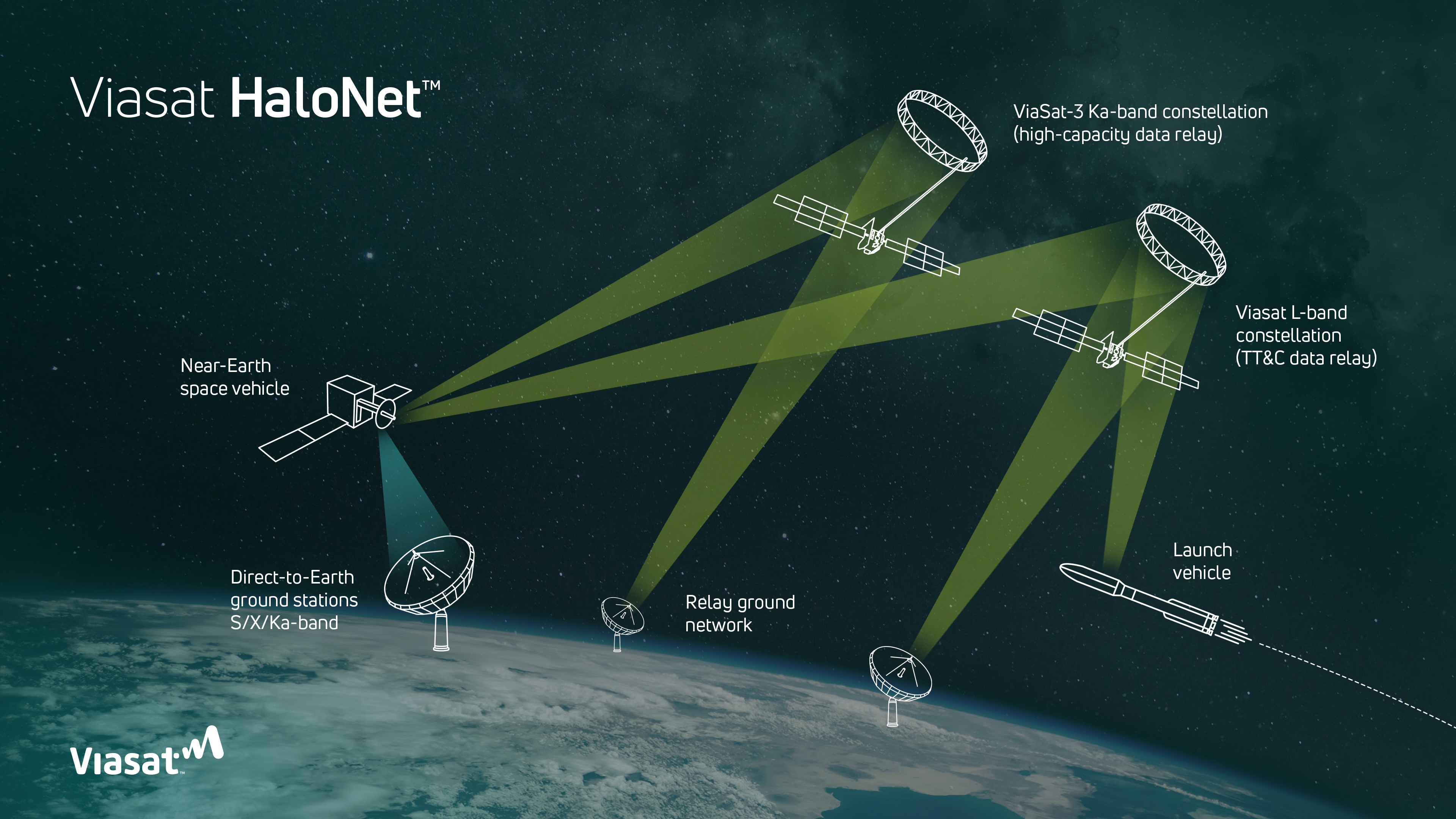
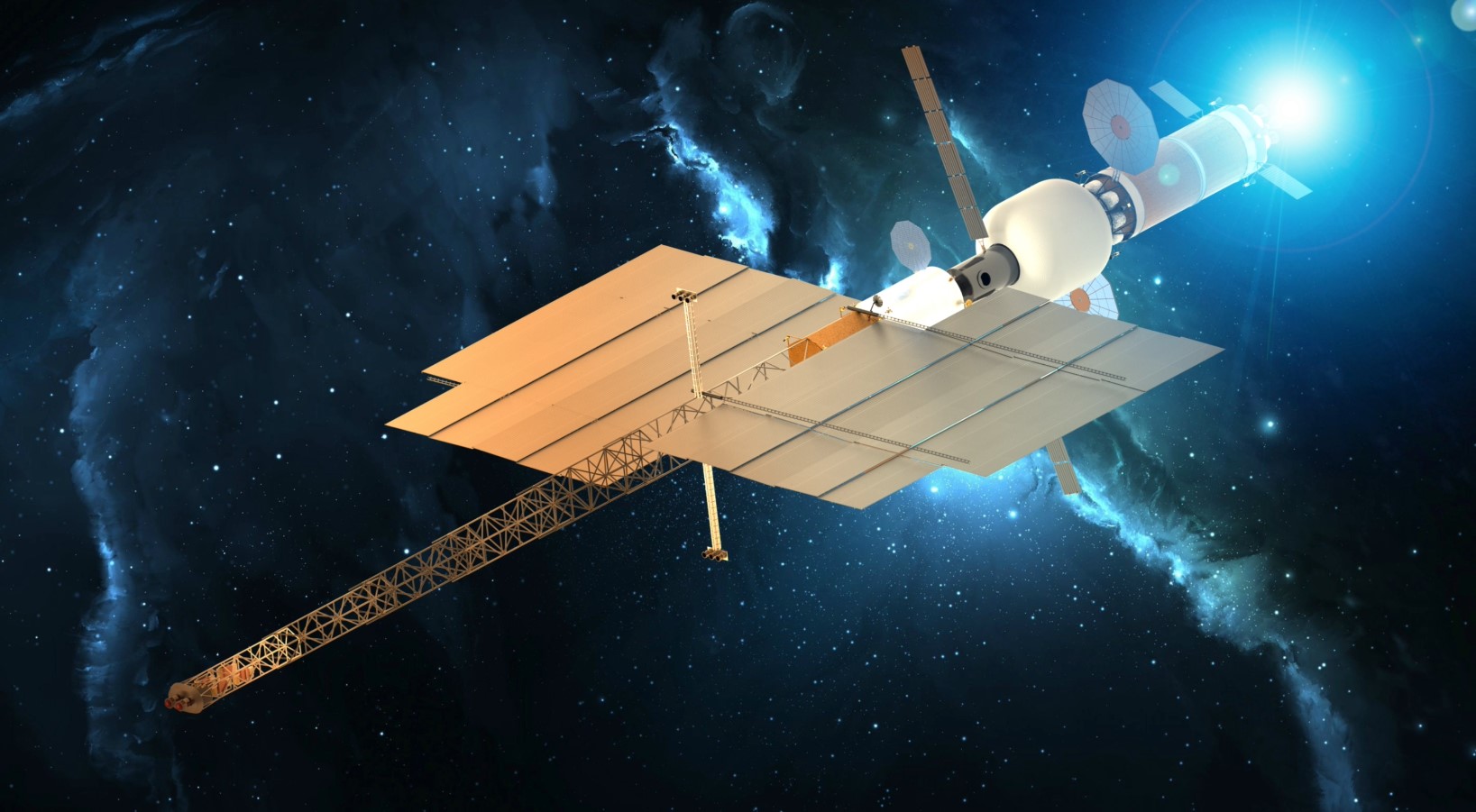
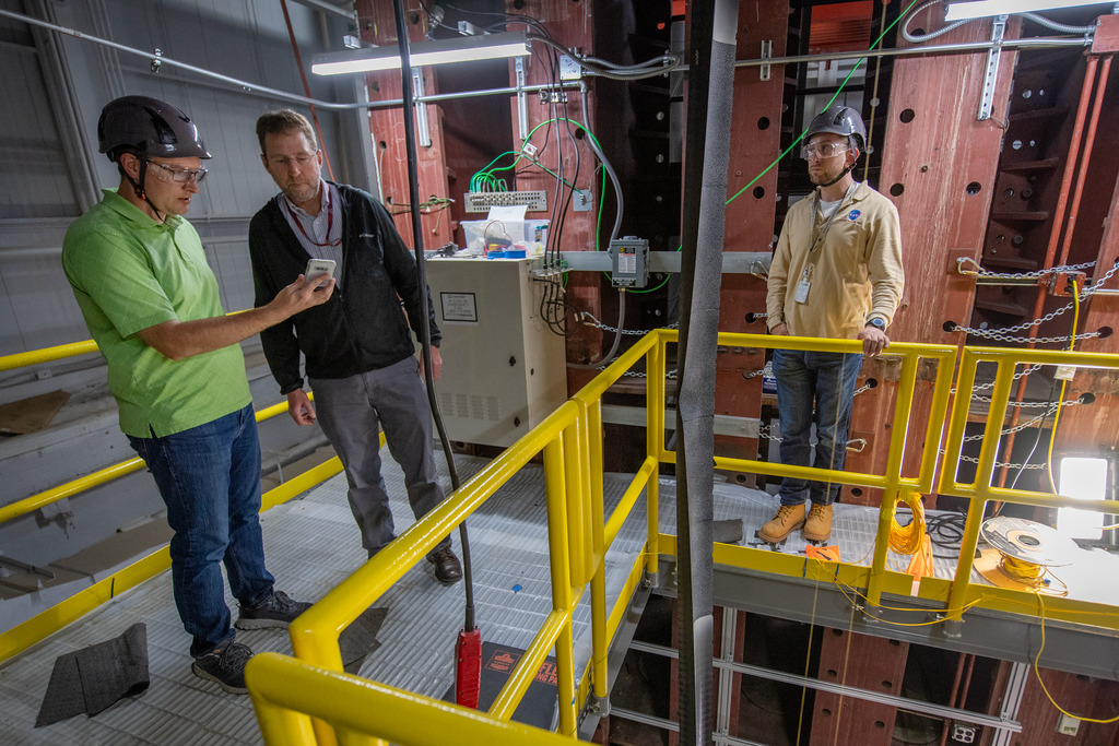
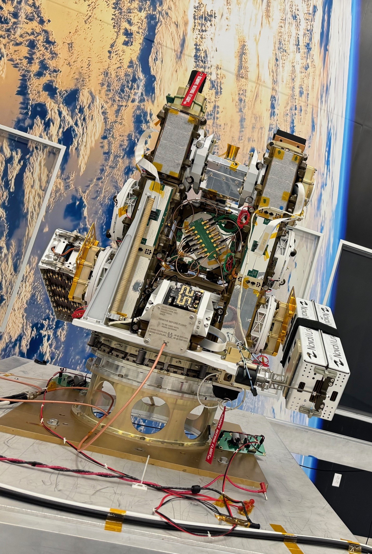