
NASA - Breaking News
Sols 4161-4163: Double Contact Science
2 min read
Sols 4161-4163: Double Contact Science This image was taken by Mast Camera (Mastcam) onboard NASA’s Mars rover Curiosity on Sol 4159 (2024-04-18 13:24:29 UTC). NASA/JPL-Caltech/MSSSEarth planning date: Friday, April 19, 2024
Curiosity has a three-sol weekend plan coming up as it makes progress along the edge of upper Gediz Vallis ridge. We have observations planned to investigate multiple bedrock targets with interesting rippled textures, dark-toned float, and the ridge. With two contact science targets, lots of targeted and untargeted remote observations, and a drive scheduled, Curiosity will have a busy three-sol plan ahead!
On the first sol of the plan, we have two contact science bedrock targets for MAHLI and APXS to analyze. MAHLI will image these targets up close, and APXS will acquire spectra from the targets for analysis of their elemental compositions. One of these bedrock targets (“Florence Lake”) is light-toned with laminations and will be brushed first to remove the dust on its surface. The other contact science target (“Mist Falls”) is a block of unbrushed, light-toned bedrock with a rippled texture. MAHLI also has a rotational stereo observation of “Castle Rock Spire” (a light-toned block of bedrock) and observations of the REMS UV sensor. In addition to bedrock observations by MAHLI and APXS, ChemCam has a LIBS observation of dark-toned float target “Silver Peak” on the first sol of this plan. ChemCam will also acquire long-distance RMIs of the rim of upper Gediz Vallis ridge and Fascination Turret to document stratigraphy. Mastcam will acquire mosaics to document exposed bedding, Kukenan butte, and Pinnacle Ridge.
Observations of Pinnacle Ridge by Mastcam will complement the ChemCam long-distance RMI observation of it on the second sol of the plan. This sol also has a ChemCam LIBS observation of “Needle Lake” to document different degrees of erosion of bedrock across laminations and a ChemCam passive dark test. Mastcam will image the two LIBS targets and will also acquire several mosaics of “Pahoa Island”, “Quail Flat”, and “The Nose” to document light-toned laminated bedrock, ripple structures, and characteristics of a dark float rock, respectively. On the second sol Curiosity will drive away. The third sol of the plan features untargeted remote observations, including ChemCam Passive Sky activities, dust devil observations, and Mastcam tau measurements.
Written by Abigail Knight, Graduate Student at Washington University
Share Details Last Updated Apr 22, 2024 Related Terms Explore More 5 min read Why is Methane Seeping on Mars? NASA Scientists Have New IdeasArticle
9 hours ago
3 min read Sols 4159-4160: A Fully Loaded First Sol
Article
4 days ago
3 min read Comet Geyser: Perseverance’s 21st Rock Core
Article
6 days ago
Keep Exploring Discover More Topics From NASA Mars
Mars is no place for the faint-hearted. It’s dry, rocky, and bitter cold. The fourth planet from the Sun, Mars…
All Mars Resources
Rover Basics
Mars Exploration Science Goals
NASA Astronaut to Inspire Artemis Generation in Boston
April 22, 2024
NASA astronaut Stephen Bowen, along with representatives from NASA and the International Space Station National Laboratory, will visit Boston on Wednesday, April 24, and Thursday, April 25, as part of the agency’s Destination Station to highlight research opportunities aboard the station.
Destination Station was created to educate the public and engage prospective researchers about the benefits, capabilities, and opportunities to use the space station. The space station has been continuously inhabited for more than 23 years, enabling more than 5,000 researchers to conduct more than 3,500 innovative experiments in the areas of biology and biotechnology, human health, space and physical science, and technology.
Throughout the week, NASA and the ISS National Lab will meet with a variety of academic institutions, business incubators, and private-sector companies with ties to the Boston community. During the visits, Bowen will provide perspectives on living and working in space.
Media who wish interview Bowen during the outreach events in Boston, should contact Kara Slaughter at kara.c.slaughter@nasa.gov or 281-483-5111.
Bowen was the first submarine officer selected to be a NASA astronaut. He most recently served as commander of NASA’s SpaceX Crew-6 mission to the station where he was part of a six-month research mission, Expedition 69. He is a veteran of three space shuttle flights to the station, including STS-126, STS-132, and STS-133. Bowen has logged a total of 227 days in space and conducted 10 extravehicular activities in his career. His 10 spacewalks make him one of five humans who have conducted that many spacewalks and he is third on the all-time list for most cumulative spacewalking time. Bowen and the crews of Expedition 68 and 69 conducted more than 200 science experiments including tissue chip research, bioprinting human cells and tissues in space, and studying antibodies in microgravity. Bowen is a Massachusetts native and earned his bachelor’s degree from the United States Naval Academy in Annapolis, Maryland, and his master’s degree from the Massachusetts Institute of Technology in Cambridge.
Over the years, NASA’s Destination Station has led to research collaborations aboard the orbiting laboratory with a variety of academic and commercial companies. This visit also is a prelude to the 13th annual International Space Station Research and Development Conference at the Boston Marriott Copley Square from July 29 – Aug. 1, 2024.
Learn more about the International Space Station and its crews at:
Discover the International Space Station U.S. National Laboratory at:
https://www.issnationallab.org
-end-
Kara Slaughter
Johnson Space Center, Houston
281-483-5111
NASA Invites Media to Learn About New Tech Mission Powered by the Sun
A new NASA mission is testing a new way to navigate our solar system by hoisting its sail into space – not to catch the wind, but the propulsive power of sunlight.
NASA’s Advanced Composite Solar Sail System is led by the agency’s Ames Research Center in California’s Silicon Valley. The microwave oven-sized CubeSat is scheduled to launch aboard a Rocket Lab Electron rocket from the company’s Launch Complex 1 on the Mahia Peninsula of New Zealand. The launch window opens at 3 p.m. PDT on Tuesday, April 23 (10 p.m. UTC). Successful deployment and operation of the solar sail’s lightweight composite booms will prove the capability and open the door to larger scale missions to the Moon, Mars, and beyond.
Once it arrives in its orbit, roughly 600 miles above Earth, the CubeSat will deploy a lightweight sunlight-powered composite solar sail system that measures more than 800 square feet. Much like a sailboat uses wind to traverse the ocean, the solar sail technology will use the pressure of sunlight to travel through space and perform a series of maneuvers to demonstrate orbit raising and lowering. Throughout the demonstration, the spacecraft may be visible to the naked eye in the night sky.
Media interested in scheduling an interview with one of the NASA Ames engineers involved with the development of the CubeSat should email the NASA Ames Office of Communications at arc-dl-newsroom@mail.nasa.gov.
A media resource reel including animated clips of the solar sail system is available here.
Get launch updates, breaking news, and images on the small satellites blog as well as NASA Ames’ Instagram, Facebook, and X.
For more information about NASA’s Ames Research Center, visit:
-end-
Rachel Hoover
Ames Research Center, Silicon Valley, Calif.
650-604-4789
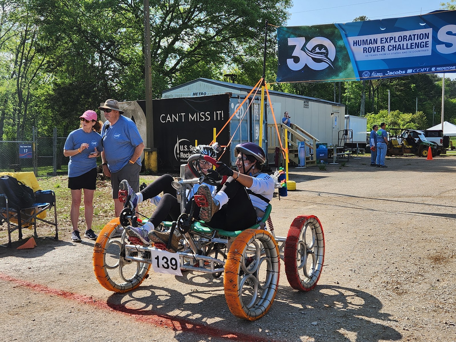
NASA Announces 30th Human Exploration Rover Challenge Winners
NASA announced the winners of the 30th Human Exploration Rover Challenge (HERC) April 22, with Parish Episcopal School, from Dallas, winning first place in the high school division, and the University of Alabama in Huntsville, capturing the college/university title.
The annual engineering competition – one of NASA’s longest standing challenges – held its concluding event April 19 and April 20, at the U.S. Space & Rocket Center in Huntsville, Alabama, near NASA’s Marshall Space Flight Center. The complete list of 2024 award winners is provided below:
High School Division
- First Place: Parish Episcopal School, Dallas
- Second Place: Academy of Arts, Careers and Technology, Reno, Nevada
- Third Place: Escambia High School, Pensacola, Florida
College/University Division
- First Place: University of Alabama in Huntsville
- Second Place: Instituto Tecnológico de Santo Domingo, Dominican Republic
- Third Place: Campbell University, Buies Creek, North Carolina
Ingenuity Award
- University of West Florida, Pensacola, Florida
Phoenix Award
- High School Division: East Central High School, Moss Point, Mississippi
- College/University Division: North Dakota State University, Fargo, North Dakota
Task Challenge Award
- High School Division: Erie High School, Erie, Colorado
- College/University Division: South Dakota School of Mines and Technology, Rapid City, South Dakota
Project Review Award
- High School Division: Parish Episcopal School, Dallas
- College/University Division: University of Alabama in Huntsville
Featherweight Award
- Rhode Island School of Design, Providence, Rhode Island
Safety Award
- High School Division: NPS International School, Singapore
- College/University Division: Instituto Especializado de Estudios Superiores Loyola, San Cristobal, Dominican Republic
Crash and Burn Award
- KIET Group of Institutions, Delhi-NCR, India
Jeff Norris and Joe Sexton Memorial Pit Crew Award
- High School Division: Erie High School, Erie, Colorado
- College/University Division: Campbell University, Buies Creek, North Carolina
Team Spirit Award
- Instituto Tecnológico de Santo Domingo, Dominican Republic
Most Improved Performance Award
- High School Division: Jesco von Puttkamer School, Leipzig, Germany
- College/University Division: Universidad Católica Boliviana – San Pablo, La Paz, Bolivia
Social Media Award
- High School Division: Bledsoe County High School, Pikeville, Tennessee
- College/University Division: Universidad de Piura, Peru
STEM Engagement Award
- High School Division: Princess Margaret Secondary School, Surrey, British Columbia
- College/University Division: Trine University, Angola, Indiana
Artemis Educator Award
- Sadif Safarov from Istanbul Technical University, Turkey
Rookie of the Year
- Kanakia International School, Mumbai, India
More than 600 students with 72 teams from around the world participated as HERC celebrated its 30th anniversary as a NASA competition. Participating teams represented 42 colleges and universities and 30 high schools from 24 states, the District of Columbia, Puerto Rico, and 13 other nations from around the world. Teams were awarded points based on navigating a half-mile obstacle course, conducting mission-specific task challenges, and completing multiple safety and design reviews with NASA engineers.
“This student design challenge encourages the next generation of scientists and engineers to engage in the design process by providing innovative concepts and unique perspectives,” said Vemitra Alexander, HERC activity lead for NASA’s Office of STEM Engagement at Marshall. “While celebrating the 30th anniversary of the challenge, HERC also continues NASA’s legacy of providing valuable experiences to students who may be responsible for planning future space missions including crewed missions to other worlds.”
HERC is one of NASA’s eight Artemis Student Challenges reflecting the goals of the Artemis program, which seeks to land the first woman and first person of color on the Moon while establishing a long-term presence for science and exploration. NASA uses such challenges to encourage students to pursue degrees and careers in the fields of science, technology, engineering, and mathematics.
HERC is managed by NASA’s Southeast Regional Office of STEM Engagement at Marshall. Since its inception in 1994, more than 15,000 students have participated in HERC – with many former students now working at NASA, or within the aerospace industry.
To learn more about HERC, please visit:
https://www.nasa.gov/roverchallenge/home/index.html
-end-
Gerelle Dodson
NASA Headquarters, Washington
202-358-4637
gerelle.q.dodson@nasa.gov
Taylor Goodwin
Marshall Space Flight Center, Huntsville, Ala.
256-544-0034
taylor.goodwin@nasa.gov
NASA Nurtures Promising Tech Ideas from Small Businesses
New space technology ideas emerge every day from innovators across the country, and NASA’s Small Business Innovation Research (SBIR) program on Monday selected more than 100 projects for funding. This program offers small businesses in the United States early-stage funding and support to advance the agency’s goals of exploring the unknown in air and space while returning benefits to Earth.
Specifically, NASA’s SBIR program awarded $93.5 million in Phase II contracts to bring 107 new ideas to life from 95 selected small businesses. Of these businesses, nearly 80% have less than 50 employees, and 21% are receiving their first Phase II award, valued at up to $850,000 each. Each small business was also eligible to apply for up to $50,000 in Technical and Business Assistance program funding to help find new market opportunities and shape their commercialization roadmap.
“We are thrilled to support this diverse set of companies as they work diligently to bring their technologies to market,” said Jenn Gustetic, director of Early Stage Innovation and Partnerships with NASA’s Space Technology Mission Directorate (STMD) at the agency’s headquarters in Washington. “Inclusive innovation is integral to mission success at NASA, and we’re excited to see that 29% of the awardees are from underrepresented groups, including 11% women-owned businesses.”
In Phase II, awardees will build on their success from the program’s first phase to bring their technologies closer to real-world use. The companies have 24 months to execute their plans, which focus on their technologies’ path to commercialization.
For example, NASA selected women-owned and first-time NASA Phase II awardee nou Systems, Inc. in Huntsville, Alabama, for its genetic testing instrument. While portable genetic sequencing already exists, field sequencing – that would allow DNA analysis anywhere on Earth or off planet – remains unfeasible as the preparation of the DNA Library remains an intensely manual process, needing a trained wet lab technician and several pieces of laboratory equipment. The Phase II technology takes advantage of several cross-enabling technologies, creating an instrument to automate the genetic sequencing process.
“Our program works directly with small businesses to forge innovative concepts and technologies that drive impact for NASA projects as well as a myriad of commercial endeavors,” said Jason L. Kessler, program executive for NASA’s SBIR and Small Business Technology Transfer (STTR) program at NASA Headquarters. “This collaboration results in realized opportunities not only for NASA but all of humanity.”
This includes technologies aiming to reduce astronaut workload and improve robotic scientific endeavors on the Moon and Mars. PickNik Inc. based in Boulder, Colorado, will use its Phase II award to continue developing a hardware-agnostic platform for supervised autonomy that empowers humans to command a remote robot to complete complex tasks with minimal input, which could support the Artemis program. Outside of NASA, PickNik’s software product may be of interest to commercial space customers working on low Earth orbit destinations, in-space servicing, and more, as well as on Earth in areas like warehouse management, oil rig maintenance, and deep-sea exploration.
The NASA SBIR program is open to U.S. small businesses to develop an innovation or technology. The program is part of STMD and managed by NASA’s Ames Research Center in California’s Silicon Valley.
To learn more about the NASA SBIR program, visit:
-end-
Jimi Russell
Headquarters, Washington
james.j.russell@nasa.gov
202-358-1600
Our Beautiful Water World
This Jan. 30, 2012 image of Earth was created from photographs taken by the Visible/Infrared Imager Radiometer Suite (VIIRS) instrument aboard the Suomi NPP satellite. Many features of North America and the Western Hemisphere are particularly visible. The composite was created from the data collected during four orbits of the robotic satellite taken earlier in January 2012 and digitally projected onto the globe.
VIIRS collects visible and infrared imagery along with global observations of Earth’s land, atmosphere, cryosphere, and ocean, extending observational records collected by similar instruments aboard previously launched satellites, such as NASA’s Moderate Resolution Imaging Spectroradiometer (MODIS) and NOAA’s Advanced Very High Resolution Radiometer (AVHRR).
Help us celebrate Earth Day by sharing a #GlobalSelfie.
Image Credit: NASA
‘Vast and Rich:’ Studying the Ocean With NASA Computer Simulations
To view this video please enable JavaScript, and consider upgrading to a web browser that supports HTML5 video
A tool developed at NASA’s Advanced Supercomputing division provides researchers with a global view of their ocean simulation in high resolution. In this part of the global visualization, the Gulf Stream features prominently. Surface water speeds are shown ranging from 0 meters per second (dark blue) to 1.25 meters (about 4 feet) per second (cyan). The video is running at one simulation day per second. The data used comes from the Estimating the Circulation and Climate of the Ocean (ECCO) consortium. Credits: NASA/Bron Nelson, David Ellsworth“Every time I help with visualizing [ocean] simulation data, I learn about an entirely new area of ocean or climate research, and I’m reminded of how vast and rich this area of research is. And…the real magic happens at the intersection and interaction of simulated and observed data.
It is a great honor – and a thrill – to collaborate with devoted, world-class scientists doing such important, cutting-edge research and sometimes to even help them learn something new about their science.”
Dr. Nina McCurdy
Data visualization scientist with the NASA Advanced Supercomputing division at NASA’s Ames Research Center in California’s Silicon Valley
This Earth Day, learn more about the work of Nina and other Ames researchers studying our planet: Celebrating Our Ocean World at NASA in Silicon Valley.
Why is Methane Seeping on Mars? NASA Scientists Have New Ideas
Maksym Bocharov
The most surprising revelation from NASA’s Curiosity Mars Rover — that methane is seeping from the surface of Gale Crater — has scientists scratching their heads.
Living creatures produce most of the methane on Earth. But scientists haven’t found convincing signs of current or ancient life on Mars, and thus didn’t expect to find methane there. Yet, the portable chemistry lab aboard Curiosity, known as SAM, or Sample Analysis at Mars, has continually sniffed out traces of the gas near the surface of Gale Crater, the only place on the surface of Mars where methane has been detected thus far. Its likely source, scientists assume, are geological mechanisms that involve water and rocks deep underground.
If that were the whole story, things would be easy. However, SAM has found that methane behaves in unexpected ways in Gale Crater. It appears at night and disappears during the day. It fluctuates seasonally, and sometimes spikes to levels 40 times higher than usual. Surprisingly, the methane also isn’t accumulating in the atmosphere: ESA’s (the European Space Agency) ExoMars Trace Gas Orbiter, sent to Mars specifically to study the gas in the atmosphere, has detected no methane.
Why do some science instruments detect methane on the Red Planet while others don’t?
“It’s a story with a lot of plot twists,” said Ashwin Vasavada, Curiosity’s project scientist at NASA’s Jet Propulsion Laboratory in Southern California, which leads Curiosity’s mission.
Methane keeps Mars scientists busy with lab work and computer modeling projects that aim to explain why the gas behaves strangely and is detected only in Gale Crater. A NASA research group recently shared an interesting proposal.
Reporting in a March paper in the Journal of Geophysical Research: Planets, the group suggested that methane — no matter how it’s produced — could be sealed under solidified salt that might form in Martian regolith, which is “soil” made of broken rock and dust. When temperature rises during warmer seasons or times of day, weakening the seal, the methane could seep out.
Led by Alexander Pavlov, a planetary scientist at NASA’s Goddard Space Flight Center in Greenbelt, Maryland, the researchers suggest the gas also can erupt in puffs when seals crack under the pressure of, say, a rover the size of a small SUV driving over it. The team’s hypothesis may help explain why methane is detected only in Gale Crater, Pavlov said, given that’s it’s one of two places on Mars where a robot is roving and drilling the surface. (The other is Jezero Crater, where NASA’s Perseverance rover is working, though that rover doesn’t have a methane-detecting instrument.)
Pavlov traces the origin of this hypothesis to an unrelated experiment he led in 2017, which involved growing microorganisms in a simulated Martian permafrost (frozen soil) infused with salt, as much of Martian permafrost is.
Pavlov and his colleagues tested whether bacteria known as halophiles, which live in saltwater lakes and other salt-rich environments on Earth, could thrive in similar conditions on Mars.
The microbe-growing results proved inconclusive, he said, but the researchers noticed something unexpected: The top layer of soil formed a salt crust as salty ice sublimated, turning from a solid to a gas and leaving the salt behind.
Permafrost on Mars and Earth
“We didn’t think much of it at the moment,” Pavlov said, but he remembered the soil crust in 2019, when SAM’s tunable laser spectrometer detected a methane burst no one could explain.
“That’s when it clicked in my mind,” Pavlov said. And that’s when he and a team began testing the conditions that could form and crack hardened salt seals.
Pavlov’s team tested five samples of permafrost infused with varying concentrations of a salt called perchlorate that’s widespread on Mars. (There’s likely no permafrost in Gale Crater today, but the seals could have formed long ago when Gale was colder and icier.) The scientists exposed each sample to different temperatures and air pressure inside a Mars simulation chamber at NASA Goddard.
Periodically, Pavlov’s team injected neon, a methane analog, underneath the soil sample and measured the gas pressure below and above it. Higher pressure beneath the sample implied the gas was trapped. Ultimately, a seal formed under Mars-like conditions within three to 13 days only in samples with 5% to 10% perchlorate concentration.
This is a sample of mock Martian regolith, which is “soil” made of broken rock and dust. It’s one of five samples that scientists infused with varying concentrations of a salt called perchlorate that’s widespread on Mars. They exposed each sample to Mars-like conditions in the Mars simulation chamber at NASA’s Goddard Space Flight Center in Greenbelt, Maryland. The brittle clumps in the sample above show that a seal of salt did not form in this sample because the concentration of salt was too low. NASA/Alexander Pavlov This image is of another sample of mock Martian “soil” after it was removed from the Mars simulation chamber. The surface is sealed with a solid crust of salt. Alexander Pavlov and his team found that a seal formed after a sample spent three to 13 days under Mars-like conditions, and only if it had 5% to 10% perchlorate salt concentration. The color is lighter in the center where the sample was scratched with a metal pick. The light color indicates a drier soil underneath the top layer, which absorbed moisture from the air as soon as the sample was removed from the simulation chamber, turning brown. NASA/Alexander PavlovThat’s a much higher salt concentration than Curiosity has measured in Gale Crater. But regolith there is rich in a different type of salt minerals called sulfates, which Pavlov’s team wants to test next to see if they can also form seals.
Curiosity rover has arrived at a region believed to have formed as Mars’ climate was drying.
Improving our understanding of methane generation and destruction processes on Mars is a key recommendation from the 2022 NASA Planetary Mission Senior Review, and theoretical work like Pavlov’s is critical to this effort. However, scientists say they also need more consistent methane measurements.
SAM sniffs for methane only several times a year because it is otherwise busy doing its primary job of drilling samples from the surface and analyzing their chemical makeup.
In 2018, NASA announced that the Sample Analysis at Mars chemistry lab aboard the Curiosity Rover discovered ancient organic molecules that had been preserved in rocks for billions of years. Findings like this one help scientists understand the habitability of early Mars and pave the way for future missions to the Red Planet.Credit: NASA’s Goddard Space Flight Center
Download this video in HD formats from NASA Goddard’s Scientific Visualization Studio
“Methane experiments are resource intensive, so we have to be very strategic when we decide to do them,” said Goddard’s Charles Malespin, principal investigator for SAM.
Yet, to test how often methane levels spike, for instance, would require a new generation of surface instruments that measure methane continuously from many locations across Mars, scientists say.
“Some of the methane work will have to be left to future surface spacecraft that are more focused on answering these specific questions,” Vasavada said.
By Lonnie Shekhtman
NASA’s Goddard Space Flight Center, Greenbelt, Md.
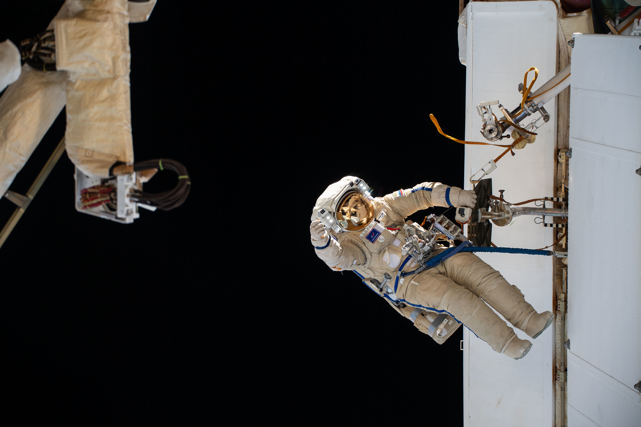
NASA Sets Coverage of Roscosmos Spacewalk Outside Space Station
NASA will provide live coverage, beginning at 10:30 a.m. EDT Thursday, April 25, as two Roscosmos cosmonauts conduct a spacewalk outside the International Space Station. The spacewalk is expected to begin at 10:55 a.m. and could last up to seven hours.
NASA will stream the spacewalk on NASA+, NASA Television, the NASA app, YouTube, and the agency’s website. Learn how to stream NASA TV through a variety of platforms including social media.
Expedition 71 crewmates Oleg Kononenko and Nikolai Chub will venture outside the station’s Poisk airlock to complete the deployment of one panel on a synthetic radar system on the Nauka module.The two cosmonauts will also install equipment and experiments on the Poisk module to analyze the level of corrosion on station surfaces and modules.
The spacewalk will be the 270th in support of space station, and will be the seventh for Kononenko, who will wear the Orlan spacesuit with the red stripes, and the second for Chub, who will wear the spacesuit with the blue stripes.
Get breaking news, images, and features from the space station on the station blog, Instagram, Facebook, and X.
Learn more about International Space Station research and operations at:
-end-
Joshua Finch / Claire O’Shea
Headquarters, Washington
202-358-1100
joshua.a.finch@nasa.gov / claire.a.o’shea@nasa.gov
Sandra Jones
Johnson Space Center, Houston
281-483-5111
sandra.p.jones@nasa.gov
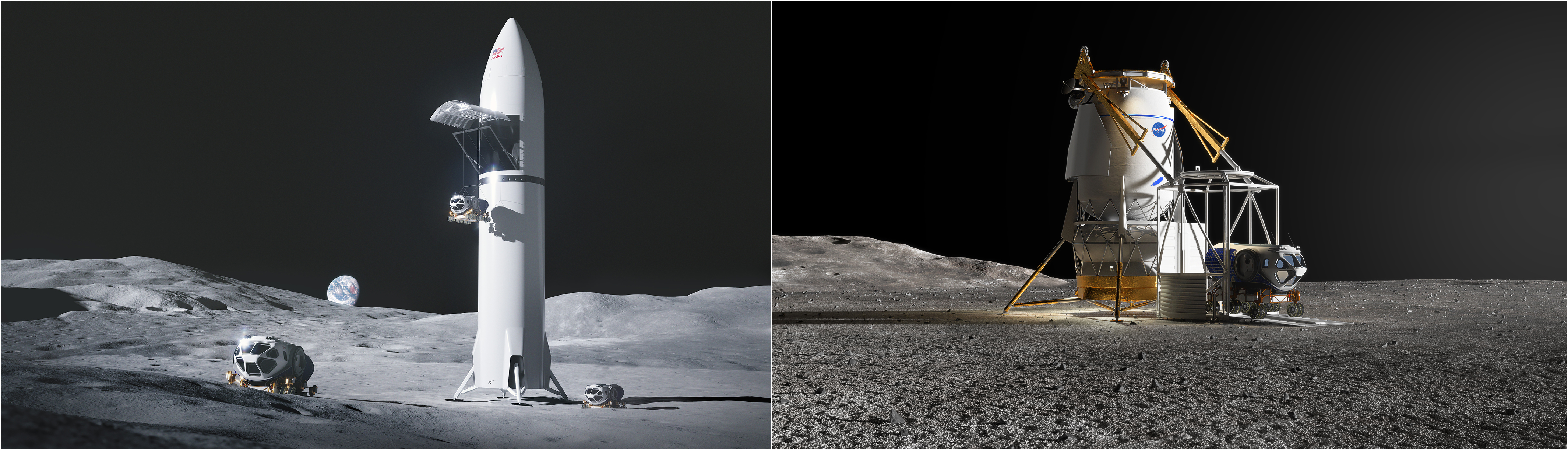
Work Underway on Large Cargo Landers for NASA’s Artemis Moon Missions
Under NASA’s Artemis campaign, the agency and its partners will send large pieces of equipment to the lunar surface to enable long-term scientific exploration of the Moon for the benefit of all. NASA’s human landing system providers, SpaceX and Blue Origin, are beginning development of lunar landers for large cargo deliveries to support these needs.
NASA has contracted SpaceX and Blue Origin to provide landing systems to take astronauts to the Moon’s surface from lunar orbit, beginning with Artemis III. The agency has asked the two companies to develop cargo versions of their human lunar landers as an option under their existing contracts. These cargo variants are expected to land approximately 26,000 – 33,000 pounds (12 to 15 metric tons) of payload on the lunar surface and be in service no earlier than the Artemis VII mission.
“It’s essential that NASA has the capability to land not just astronauts, but large pieces of equipment, such as pressurized rovers, on the Moon for maximum return on science and exploration activities,” said Lisa Watson-Morgan, Human Landing System Program Manager at NASA’s Marshall Space Flight Center in Huntsville, Alabama. “Beginning this work now allows SpaceX and Blue Origin to leverage their respective human lander designs to provide cargo variants that NASA will need in the future.”
NASA expects the cargo versions of the companies’ landers to be modified versions of the human landing systems currently being developed for Artemis III, IV, and V. Modifications will include adjustments for payload interfaces and deployment mechanisms, and the cargo variants will not have human life support systems.
This initial work allows the companies to proceed with development for their cargo landers through a preliminary design review, the step that establishes the basis for proceeding with detailed design. SpaceX is conducting its work under the NextSTEP Appendix H contract, and Blue Origin is conducting its work under NextSTEP Appendix P. NASA officially exercised the options under those contracts in November 2023 to begin work on the large cargo landers.
With Artemis, NASA will explore more of the Moon than ever before, learn how to live and work away from home, and prepare for future human missions to the Red Planet. Artemis requires the best of international space agencies, private industry, and academia to establish the infrastructure for long-term scientific research and exploration. NASA’s SLS (Space Launch System) rocket, exploration ground systems, and Orion spacecraft, along with the human landing system, next-generation spacesuits and rovers, and Gateway lunar space station are the agency’s foundation for human exploration deep space.
For more information about Artemis, visit:
Slovenia Signs Artemis Accords, Joins Pursuit of Safer Space
NASA and Slovenia affirmed their cooperation in future space endeavors on Friday as Slovenia became the 39th country to sign the Artemis Accords. The signing certified Slovenia’s commitment to pursue safe and sustainable exploration of space for the benefit of humanity and took place during a U.S.-Slovenia strategic dialogue in Ljubljana, Slovenia, at the Ministry of Foreign Affairs Offices.
“NASA welcomes Slovenia to the Artemis Accords,” said NASA Administrator Bill Nelson. “Today, the partnership between the United States and Slovenia crosses a new frontier. We live in a golden era of exploring the stars. That era will be written by nations that explore the cosmos openly, responsibly, and in peace.”
State Secretary Matevž Frangež of the Ministry of the Economy, Tourism, and Sport signed the Accords on behalf of Slovenia, with James O’Brien, Assistant Secretary of State for European and Eurasian Affairs, participating in the signing event.
“Slovenia joins the principles, values, and rules on the peaceful use of space as a common good of humanity,” Frangež said.
Rebecca Bresnik, Associate General Counsel for International and Space Law, served as the senior NASA official at the ceremony, along with her husband, Randy Bresnik, who is a NASA astronaut of Slovenian descent.
“We are delighted to welcome Slovenia to the Artemis Accords family,” said Ambassador Jamie Harpootlian, the U.S. ambassador to Slovenia “We recognize Slovenia as a rising leader in space. We look forward to taking our collaborations with Slovenia on science, technology, and innovation to new frontiers.”
In 2020, the United States and seven other countries established the Artemis Accords to establish guidelines for the peaceful exploration and use of outer space. The Accords reinforce and implement key obligations in the 1967 Outer Space Treaty. They also strengthen the commitment by the United States and signatory nations to the Registration Convention, the Rescue and Return Agreement, as well as best practices NASA and its partners support, including the public release of scientific data.
Learn more about the Artemis Accords at:
https://www.nasa.gov/artemis-accords
-end-
Lauren Low
Headquarters, Washington
202-358-1600
lauren.e.low@nasa.gov
NASA Data Helps Beavers Build Back Streams
2 min read
Preparations for Next Moonwalk Simulations Underway (and Underwater) A beaver family nibbles on aspen branches just up Logan Canyon from Utah State University, in Spawn Creek, Utah. Credit: Sarah KoenigsbergHumans aren’t the only mammals working to mitigate the effects of climate change in the Western United States. People there are also enlisting the aid of nature’s most prolific engineers – beavers. Using NASA-provided grants, two open-source programs from Boise State University in Idaho and Utah State University in Logan are making it possible for ranchers, land trust managers, nonprofits, and others to attract beavers to areas that need their help.
The Beaver Restoration Assessment Tool (BRAT) created by Utah State University uses data from satellites built at NASA’s Goddard Space Flight Center in Greenbelt, Maryland, to identify areas that need restoration and would benefit from beavers’ dam-building abilities. The Boise State University Mesic Resource Restoration Monitoring Aid (MRRMaid) program, which also uses satellite data, monitors the areas over time. Both efforts are also supported by NASA’s Research Opportunities in Space and Earth Science program and the agency’s Applied Sciences’ Ecological Conservation program.
Once a site is chosen, program staffers and landowners begin to take measures to attract beavers, or the teams may relocate them from other areas. Either way, once on site, these semiaquatic builders get to work building and maintaining dams to create the ponds. The ponds help to retain water, including runoff from snowmelt and rainstorms, that would otherwise rush through the area, causing erosion and degrading the surrounding ecosystems.
Over time, these new ponds raise the water table, support wetlands that attract more wildlife and fish, and restore native plants to the ecosystem. Beaver dams can help ranchers improve water availability on their property, supporting their operations.
NASA Landsat data helps Utah State University identify streams where beavers can be reintroduced to help improve an ecosystem. Boise State University also uses Landsat data to show just how much beavers help. The vegetation in this satellite image indicates where streams or creeks are flowing and reveals the benefits of beaver activity.Credit: NASAIn addition to being beautiful and supporting the local ecology, these moisture-rich environments can limit wildfire damage with a barrier of healthy vegetation resistant to burning. When human infrastructure is nearby, a built-in leak or other interventions by humans can be added to control the water level, preventing floods that cause property damage.
As a restoration site’s health improves, MRRMaid and BRAT use NASA satellite data to monitor those changes and analyze how the beavers benefit the ecosystem in drought-stricken areas. Community leaders can use this information and the living examples of restored sites to build new parks and recreational areas and plan future restoration projects with their furry collaborators.
Read MoreFor more information on beaver rewilding, visit:
Share Details Last Updated Apr 19, 2024 Related Terms Explore More 6 min read NASA Selects New Aircraft-Driven Studies of Earth and Climate ChangeNASA has selected six new airborne missions that include domestic and international studies of fire-induced…
Article 1 day ago 2 min read Hubble Captures a Bright Galactic and Stellar DuoThis image from the NASA/ESA Hubble Space Telescope features NGC 3783, a bright barred spiral galaxy about…
Article 1 day ago 4 min read Students Celebrate Rockets, Environment at NASA’s Kennedy Space Center Article 1 day ago Keep Exploring Discover Related TopicsEarth Observations
Earth Day News and Articles
Climate Change
Solar System
Looking Beyond the Veil
In this image released on March 9, 2024, the NIRCam (Near-Infrared Camera) on NASA’s James Webb Space Telescope gives us a more detailed view of a well-studied but still mysterious region, NGC 604. The most noticeable features are tendrils and clumps of emission that appear bright red, extending out from areas that look like clearings, or large bubbles in the nebula. Stellar winds from the brightest and hottest young stars have carved out these cavities, while ultraviolet radiation ionizes the surrounding gas. This ionized hydrogen appears as a white and blue ghostly glow.
Image Credit: NASA, ESA, CSA, STScI
NASA, FAA Partner to Develop New Wildland Fire Technologies
NASA and the Federal Aviation Administration (FAA) have established a research transition team to guide the development of wildland fire technology.
Wildland fires are occurring more frequently and at a larger scale than in past decades, according to the U.S. Forest Service. Emergency responders will need a broader set of technologies to prevent, monitor, and fight these growing fires more effectively. Under this Wildland Fire Airspace Operations research transition team, NASA and the FAA will develop concepts and test new technologies to improve airspace integration.
Current aerial firefighting operations are limited to times when aircraft have clear visibility – otherwise pilots run the risk of flying into terrain or colliding with other aircraft. Drones could overcome this limitation by enabling responders to remotely monitor and suppress these fires during nighttime and low visibility conditions, such as periods of heavy smoke. However, advanced airspace management technologies are needed to enable these uncrewed aircraft to stay safely separated and allow aircraft operators to maintain situational awareness during wildland fire management response operations.
Over the next four years, NASA’s Advanced Capabilities for Emergency Response Operations (ACERO) project, in collaboration with the FAA, will work to develop new airspace access and traffic management concepts and technologies to support wildland fire operations. These advancements will help inform a concept of operations for the future of wildland fire management under development by NASA and other government agencies. The team will test and validate uncrewed aircraft technologies for use by commercial industry and government agencies, paving the way for integrating them into future wildland fire operations.
ACERO is led out of NASA’s Ames Research Center in Silicon Valley under the agency’s Aeronautics Research Mission Directorate.
Join NASA in Celebrating Earth Day 2024 by Sharing a #GlobalSelfie
NASA invites you — and everyone else on the planet — to take part in a worldwide celebration of Earth Day with the agency’s #GlobalSelfie event. While NASA satellites constantly look at Earth from space, on Earth Day we’re asking you to step outside and take a picture of yourself in your corner of the world. Then post it to social media using the hashtag #GlobalSelfie.
Bonus points if your #GlobalSelfie features your favorite body of water! About 71% of our Blue Marble is covered by water, and that water is one of the main reasons why Earth is like no other planet we’ve found in this solar system, or beyond.
Why #GlobalSelfie?
NASA astronauts brought home the first ever images of the whole planet from space. Now NASA satellites capture new images of Earth every second. With Earth-observing missions orbiting our home planet right now, and more set to launch this year, NASA studies Earth’s atmosphere, land and oceans in all their complexity.
For Earth Day, we want everyone to share the planet from their point of view. Need an idea of what kind of picture to take? Get outside and show us mountains, parks, the sky, rivers, lakes – and you! Wherever you are, there’s your picture.
How do I take part?
Post your photo to social media using the hashtag #GlobalSelfie. Make it public so we can see, and celebrate #EarthDay with you!
NASA Selects New Aircraft-Driven Studies of Earth and Climate Change
5 min read
NASA Selects New Aircraft-Driven Studies of Earth and Climate ChangeNASA has selected six new airborne missions that include domestic and international studies of fire-induced clouds, Arctic coastal change, air quality, landslide hazards, shrinking glaciers, and emissions from agricultural lands. NASA’s suite of airborne missions complement what scientists can see from orbit, measure from the ground, and simulate in computer models.
Funded through the agency’s Earth Venture program, the missions center around the use of instruments mounted on aircraft to make measurements in finer detail—both in spatial resolution and shorter time scales—than can be made by many satellites. Competitively selected, the missions provide opportunities to supplement satellite observations and make innovative measurements.
“These missions will help us interpret what our current satellites are seeing from space and test new ideas and techniques for our upcoming Earth System Observatory,” said Karen St. Germain, director of NASA’s Earth Science Division. “There is also a strong focus on actionable Earth science—gathering fundamental observations that have connections to our economy and societal decision-making and information needs.”
NASA’s newest Earth Ventures missions include studies of how climate change is altering carbon emissions and water and ice flows across Arctic coastal regions. Credit: Landsat/USGS/NASA Earth ObservatoryRoughly $120 million has been allotted for the six missions, which will deploy at various times from 2026 to 2029. Three lead investigators were chosen for each mission, with at least one required to be an early career scientist. Full staffing of the science teams and selection of complementary instruments will be competed in the coming months. These changes in the selection process were made to promote diversity, equity, and inclusion in the teams.
“We are constantly looking to foster the growth of the next generation of scientists,” said Barry Lefer, the program manager who led the Earth Venture selection panels at NASA Headquarters in Washington. “This round of missions will put an extra emphasis on bringing new people into mission planning and leadership.”
The six missions include:
Arctic coastal changeMaria Tzortziou of the City College of New York will lead a project to observe changes in river systems on the North Slope of Alaska. Known as FORTE (short for Arctic Coastlines–The Frontlines of Rapidly Transforming Ecosystems), the project will combine optical and radar measurements from planes, helicopters, boats, and drones to measure water flows and chemistry and observe how ecosystems respond to changing climate. The team will collaborate with indigenous communities to sustain observations over time.
Clouds created by fire In one of NASA’s newest Earth Ventures missions, researchers will investigate the conditions that lead to the formation of pyrocumulonimbus “fire clouds.” Extreme wildland fires can create their own weather and inject smoke into the stratosphere. Courtesy of David Peterson, U.S. Naval Research LaboratoryIn PYREX—the Pyrocumulonimbus Experiment—David Peterson of the Naval Research Laboratory in Washington will lead a study of pyrocumulonimbus clouds, which form when wildfires burn hot enough to make their own weather. Flying over the western U.S. and Canada, researchers will examine the fire characteristics that produce pyrocumulonimbus, while exploring the mechanisms that lead these clouds to inject smoke into the stratosphere, where it can have climate effects.
Urban air pollutionJames Crawford of NASA’s Langley Research Center in Hampton, Virginia, will lead HAMAQ (Hemispheric Airborne Measurements of Air Quality), a project that capitalizes on the recent launches of NASA’s TEMPO pollution-monitoring satellite instrument and comparable measurements made by Korean and European satellites. Over Mexico City and a U.S. city to be determined, scientists will investigate areas of poor air quality and test how satellite information can help improve ground-based forecasting and mitigation strategies.
Shifting weather, shifting landsClimate change is leading to more extreme droughts and rainfall events that affect the stability of hillslopes and the soil and rock on them. Led by Alexander Handwerger of NASA’s Jet Propulsion Laboratory in Pasadena, California, LACCE (Landslide Climate Change Experiment) will combine airborne measurements with land-based sensors to track the way slopes and landslides are changing as water moves differently across the landscape.
Glacier retreatJohn Holt of the University of Arizona will lead Snow4Flow, a project to quantify the retreat of glaciers and ice sheets in ways that can lead to better projections of land-ice change. In Alaska, southeastern Greenland, the Canadian Arctic, and Svalbard, the team will use microwave and high-frequency radar sounders to measure snow accumulation, ice melting, and changes in ice thickness and motion.
Agricultural emissionsWhile the burning of fossil fuels remains the leading source of carbon in our atmosphere, farmlands and ranchlands are also substantial sources of gas and particle emissions. In the NTERFAACE (Nitrogen and Carbon Terrestrial Fluxes: Agriculture, Atmospheric Composition, and Ecosystems) mission, led by Glenn Wolfe of NASA’s Goddard Space Flight Center in Greenbelt, Maryland, researchers will measure the amount of greenhouse gases, nitrogen, and other pollutants that are emitted from agricultural lands across the United States.
The PYREX and Snow4Flow missions are funded at $30 million each, while the other four projects will each receive $15 million. These six investigations were selected from 42 proposals. The 2024 selections represent the fourth series of NASA Earth Venture investigations, which were first recommended by the National Research Council in 2007.
For more on NASA Earth Science, visit: science.nasa.gov/earth
Share Details Last Updated Apr 19, 2024 Contact Michael Carlowicz michael.j.carlowicz@nasa.gov Location Goddard Space Flight Center Related Terms Explore More 4 min read AI for Earth: How NASA’s Artificial Intelligence and Open Science Efforts Combat Climate ChangeArticle
19 hours ago
4 min read NASA Data Shows How Drought Changes Wildfire Recovery in the West
Article
3 weeks ago
5 min read Early Adopters of NASA’s PACE Data to Study Air Quality, Ocean Health
Article
4 weeks ago
Keep Exploring Discover Related Topics Earth
Your home. Our Mission. And the one planet that NASA studies more than any other.
Climate Change
NASA is a global leader in studying Earth’s changing climate.
Air Quality
Air pollution is a significant threat to human health and our environment. Instruments on NASA satellites, along with airborne and…
How is Earth’s sea ice faring in our warming world?
Hubble Captures a Bright Galactic and Stellar Duo
2 min read
Hubble Captures a Bright Galactic and Stellar Duo This image from the NASA/ESA Hubble Space Telescope features the barred spiral galaxy NGC 3783. ESA/Hubble & NASA, M. C. Bentz, D. J. V. RosarioThis image from the NASA/ESA Hubble Space Telescope features NGC 3783, a bright barred spiral galaxy about 130 million light-years from Earth that also lends its name to the eponymous NGC 3783 galaxy group. Like galaxy clusters, galaxy groups are aggregates of gravitationally bound galaxies. Galaxy groups, however, are less massive and contain fewer members than galaxy clusters do: whereas galaxy clusters can contain hundreds or even thousands of constituent galaxies, galaxy groups do not typically include more than 50. The Milky Way is actually part of a galaxy group, known as the Local Group, which also holds two other large galaxies (Andromeda and the Triangulum galaxy), as well as several dozen satellite and dwarf galaxies. The NGC 3783 galaxy group contains 47 galaxies. It also seems to be at a fairly early stage of its evolution, making it an interesting object to study.
While the focus of this image is the spiral galaxy NGC 3783, the eye is equally drawn to the very bright object in the lower right part of this image. This is the star HD 101274. The perspective in this image makes the star and the galaxy look like close companions, but this is an illusion. HD 101274 lies only about 1,530 light-years from Earth, it is about 85,000 times closer than NGC 3783. This explains how a single star can appear to outshine an entire galaxy!
NGC 3783 is a type-1 Seyfert galaxy, which is a galaxy with a bright central region. Hubble captures it in incredible detail, from its glowing central bar to its narrow, winding arms and the dust threaded through them, thanks to five separate images taken in different wavelengths of light. In fact, the galactic center is so bright that it exhibits diffraction spikes, normally only seen on stars such as HD 101274.
Text credit: European Space Agency (ESA)
Download this image
Media Contact:
Claire Andreoli
NASA’s Goddard Space Flight Center, Greenbelt, MD
claire.andreoli@nasa.gov
Since its 1990 launch, the Hubble Space Telescope has changed our fundamental understanding of the universe.
Galaxies Stories
Asteroids, Comets, and Meteors Stories
Stars Stories
Students Celebrate Rockets, Environment at NASA’s Kennedy Space Center
At NASA’s Kennedy Space Center, sustainability and preservation efforts here on Earth are as much of a priority as rocket launches, spacecraft, and the exploration of worlds beyond our own.
In celebration of Earth Day 2024, nearly 100 students from Andrew Jackson Middle School in Titusville, Florida, and a virtual audience of students across the country, attended NASA’s Next Gen STEM Earth Day panel at the NASA News Center’s John Holliman Auditorium and press site “bullpen.”
On hand were NASA environmental and educational experts who discussed Kennedy’s unique role balancing space launch technology and protected habitat, the center’s new electric vehicle charging stations, and NASA’s Earthrise educational initiative that aims to increase science, technology, engineering, and mathematics literacy.
Bob Kline, acting chief of Kennedy’s Environmental Assurance Branch, helped students learn about the importance of protecting the habitat that is refuge to more than 1,500 species of plants and animals. NASA Kennedy shares a boundary with the Merritt Island National Wildlife Refuge and the Canaveral National Seashore, which encompass over 140,000 acres of land, waters, and protected habitats.
“Because we’re a wildlife refuge, it’s easy to think the launches would impact the wildlife, but it’s mostly the buildings that might get impacted by wildlife trying to live on them,” said Kline. “During renovations we’ve had to do special things to protect bats and other birds who live in roofs or under bridges. Everything we do, we’re very mindful of the animals, whether they’re endangered or not. We care about them deeply.”
Panelist Kim King-Wrenn, a park ranger from Merritt Island National Wildlife Refuge, echoed Kline’s message. She told students that the spaceport is one of the most biologically diverse places in the world.
Home to everything from the Florida scrub jay to endangered green sea turtles, King-Wrenn classifies Kennedy as the goldilocks of climate zones.
“Right here is where the northern temperate zone and the southern, subtropical zones come together,” King-Wrenn said. “The more habitat diversity there is, the more diverse homes there are for more kinds of animals.”
Students like 7th grader Zoe Oderman were fascinated by the coexistence of nature and technology across the spaceport. “The Vehicle Assembly Building was awesome, but I love that the beaches at Kennedy Space Center give turtles a place to lay their eggs, because other places in the area don’t,” Oderman said.
Kennedy employee Spencer Davis discussed the installation of 56 electric vehicle charging stations during his time at the NASA Transportation Office on center. The new infrastructure helps support a fleet of electric government vehicles including the all-electric crew transport vehicles that will take Artemis astronauts from their crew quarters to the launch pad.
Students from Andrew Jackson Middle School in Titusville, Florida, pose for a photo with one of the Artemis crew transportation vehicles in front of the Vehicle Assembly Building at NASA’s Kennedy Space Center in Florida on Tuesday, April 2, 2024. As part of NASA’s NextGen STEM project, the students joined others from across the country who participated virtually for an environmentally focused Earth Day briefing held inside Kennedy’s news auditorium to discuss how technology and science coexist with nature at the spaceport. NASA/Kim ShiflettLater this summer, Davis and his team will be honored at the White House for these efforts to facilitate a future of zero carbon emission government vehicles and help save taxpayer money.
“The big takeaway here is in order to charge up and drive one of Kennedy’s Chevrolet Bolts 100 miles, it only costs $2.80,” Davis said. “That’s basically the price of a soft drink.”
The students also learned about Earthrise from panelist Kelly McCarthy, program specialist with NASA’s Office of STEM Engagement at the agency’s Stennis Space Center in Mississippi.
The NASA education initiative provides educators with access to monthly collections of resources aimed at increasing STEM literacy and understanding the importance of protecting our home planet.
“Earthrise is a really good way to find out the most relevant and useful solutions-based resources that exist right now,” McCarthy said.
Besides offering their expertise on sustainable practices as well as words of encouragement to the future stewards of our planet, the panelists inspired students to pursue STEM careers, including at Kennedy.
“You can do anything you want to do out here, and if you really apply yourself you can get into any field,” Davis told the students. “Don’t be afraid to step outside the box. Don’t be afraid to do something completely different, even if it’s scary. Take every opportunity and seize the moment.”
The event was coordinated through the Next Gen STEM project in NASA’s Office of STEM Engagement, which reaches students in schools and informal classrooms across the county.
View NASA’s Next Gen STEM Earth Day Student Briefing here:
To view this video please enable JavaScript, and consider upgrading to a web browser that supports HTML5 video
AI for Earth: How NASA’s Artificial Intelligence and Open Science Efforts Combat Climate Change
4 min read
AI for Earth: How NASA’s Artificial Intelligence and Open Science Efforts Combat Climate Change Lights brighten the night sky in this image of Europe, including Poland, taken from the International Space Station. NASAAs extreme weather events increase around the world due to climate change, the need for further research into our warming planet has increased as well. For NASA, climate research involves not only conducting studies of these events, but also empowering outside researchers to do the same. The artificial intelligence (AI) efforts spearheaded by the agency offer a powerful tool to accomplish these goals.
In 2023, NASA teamed up with IBM Research to create an AI geospatial foundation model. Trained on vast amounts of NASA’s widely used Harmonized Landsat and Sentinel-2 (HLS) data, the model provides a base for a variety of AI-powered studies to tackle environmental challenges. In keeping with open science principles, the model is freely available for anyone to access.
Foundation models serve as a baseline from which scientists can develop a diverse set of applications, enabling powerful and efficient solutions. “Foundation models only know what things are represented in the data,” explained Manil Maskey, the data science lead at NASA’s Office of the Chief Science Data Officer (OCSDO). “It’s like a Swiss Army Knife—it can be used for multiple different things.”
Once a foundation model is created, it can be trained on a small amount of data to perform a specific task. To date, the Interagency Implementation and Advanced Concept Team (IMPACT) along with collaborators have demonstrated the geospatial foundation model’s capabilities by fine-tuning it to detect burn scars, to delineate flood water, and to classify crop and other land use categories.
Rectangular ponds for shrimp farming line the coast of northern Peru in this image captured on March 14, 2024 by the OLI-2 (Operational Land Imager-2) on Landsat 9. NASA Earth Observatory / Lauren DauphinBecause of the computational resources required to create the initial foundation model, a partnership was necessary for success. In this case, NASA brought the data and scientific knowledge, while IBM brought the computing power and AI algorithm optimization expertise. The team’s shared commitment to making their research accessible through open science principles ensures that their model can be useful to as many researchers as possible.
“To build a foundation model at scale, we realized early on that it’s not feasible for one institution to build it,” Maskey said. “Everything we have done on our foundation models has been open to the public, all the way from pre-training data, code, best practices, model weights, fine-tuning training data, and publications. There’s transparency, so researchers can trace why certain things were used in terms of data or model architecture.”
Following on from the success of their geospatial foundation model, NASA and IBM Research are continuing their partnership to create a new, similar model for weather and climate studies. They are collaborating with Oak Ridge National Laboratory (ORNL), NVIDIA, and several universities to bring this model to life.
This time, the main dataset will be the Modern-Era Retrospective analysis for Research and Applications, Version 2 (MERRA-2), a huge collection of atmospheric reanalysis data that spans from 1980 to the present day. Like the geospatial foundation model, the weather and climate model is being developed with an open science approach, and will be available to the public in the near future.
Covering all aspects of Earth science would take several foundation models trained on different types of datasets. However, Maskey believes those future models might someday be combined into one comprehensive model, leading to a “digital twin” of the Earth that would provide unparalleled analysis and predictions for all kinds of climate and environmental events.
Whatever innovations the future holds, NASA and IBM’s geospatial and climate foundation models will enable leaps in Earth science like never before. Though powerful AI tools will enhance researchers’ work, the team’s dedication to open science supercharges the possibilities for discovery by allowing anyone to put those tools into practice and pave the way for groundbreaking research to help better care for the planet.
For more information about open science at NASA, visit:
https://science.nasa.gov/open-science/
By Lauren Leese
Web Content Strategist for the Office of the Chief Science Data Officer
Article
1 hour ago
4 min read NASA Data Shows How Drought Changes Wildfire Recovery in the West
Article
3 weeks ago
5 min read Early Adopters of NASA’s PACE Data to Study Air Quality, Ocean Health
Article
4 weeks ago
Keep Exploring Discover Related Topics
Missions
Humans in Space
Climate Change
Solar System
Sols 4159-4160: A Fully Loaded First Sol
3 min read
Sols 4159-4160: A Fully Loaded First Sol This image was taken by Chemistry & Camera (ChemCam) onboard NASA’s Mars rover Curiosity on Sol 4158 (2024-04-17 07:52:27 UTC). NASA/JPL-Caltech/LANLEarth planning date: Wednesday, April 17, 2024
Curiosity continues to make progress along the margin of upper Gediz Vallis ridge, investigating the broken bedrock in our workspace and acquiring images of the ridge deposit as the rover drives south.
Today’s 2-sol plan focused on a DRT, contact science, and drive on the first sol, followed by untargeted remote sensing on the second sol. The team had to make some decisions at the start of planning about whether to drive on the first or second sol of this plan, and how that would affect the upcoming weekend activities. As it turned out, the team was able to fit all of the desired contact science and remote sensing activities on the first sol, in addition to the drive on the first sol, which means we’ll be able to downlink more information about our end-of-drive location to better inform planning for the weekend. Weekend plans provide opportunities for a lot of great contact science, so it will be really helpful to have that additional data down for planning.
That means the first sol of this plan is fully loaded! The plan begins with a DRT activity to expose a fresh surface on the bedrock target “Tilden Lake,” followed by APXS integrations to investigate its composition. Then the Geology theme group planned several hours of remote sensing activities, including ChemCam LIBS on the bedrock target “Curry Village,” which has a similar “dragon scale” texture (or “tire tracks”) to what we had observed in the previous workspace. This big remote sensing block also includes ChemCam long distance RMI mosaics to assess the stratigraphy at Gediz Vallis ridge and the distant butte Kukenan. These long distance RMI images reveal a lot of great detail about distant targets, like the diversity of clasts at Gediz Vallis ridge, as seen in the above image.
The plan also includes a number of Mastcam activities to characterize local textures, sedimentary structures, dark rocks, and sandy aeolian bedforms (known as Transverse Aeolian Ridges, aka TARs) in a nearby trough. The Environmental theme group also planned activities to monitor the movement of fines on the rover deck, search for dust devils, and monitor atmospheric dust. After this big remote sensing block, Curiosity will use MAHLI to image the contact science target, and then continue driving south. The second sol includes untargeted activities like an autonomously selected ChemCam AEGIS target, additional Navcam deck monitoring, and Navcam line-of-sight observations. After the drive we’ll take post drive imaging to prepare for the next plan.
Looking forward to seeing what other surprises our next workspace will reveal!
Written by Lauren Edgar, Planetary Geologist at USGS Astrogeology Science Center
Share Details Last Updated Apr 19, 2024 Related Terms Explore More 3 min read Comet Geyser: Perseverance’s 21st Rock CoreArticle
3 days ago
3 min read Sols 4157-4158: What is That??
Article
4 days ago
5 min read Sols 4154-4156: Bumpy Driving up the Mountain
Article
7 days ago
Keep Exploring Discover More Topics From NASA Mars
Mars is no place for the faint-hearted. It’s dry, rocky, and bitter cold. The fourth planet from the Sun, Mars…
All Mars Resources
Rover Basics
Mars Exploration Science Goals
